The first trailer park I ever spent much time in was the Simonton Street Trailer Park, located off upper Simonton Street not far from the Southernmost Point. It was the 1990s, and drunk tourists would stagger past the humble hand-painted sign at the entrance, unaware that within the grove of Australian pines lived the working poor of South Florida. Few residents owned cars, so bicycles were locked to fences and posts, a common sight on the island. The forty-four single-wide trailers seemed to be indiscriminately scattered as if someone had tossed them into the air to see where they’d land.
Here was the last vestige of the Key West that Jimmy Buffet immortalized. Here were today’s pirates and renegades, misfits and malcontents looking for a shaker of salt—and a place to crash. But the island troubadours were now singing a sad song: rents in Key West were higher than those in New York. Keeping a roof over your head was no small matter.
I had a friend who lived in the trailer court, and I was worried about his domestic bliss. “Roommates” seemed to proliferate in number and their names changed in dizzying flux. He’d let one person crash on his sofa, and then that person would bring over three or four other people. In addition to free rent, he’d “lend” them money—money he didn’t have, money they made him fork over, or else.
My friend was a dishwasher at a local restaurant. He couldn’t read or write. He was a victim of unspeakable childhood trauma. He allowed people to stay in his trailer because he wanted to think he was helping others who needed assistance. He himself had no bank account, no savings, and was barely hanging on.
I’d stop by when I could, and usually there’d be a crowd in the trailer of people I’d never seen before. People who had nowhere else to go. The trailer court was the last resort, a de facto shelter but it was just as doomed as the people who lived there.
Don’t look for the Simonton Street Trailer Park these days. It closed in 2019, taken over by a developer who somehow evaded the city ordinance that would’ve required him to build affordable housing units. “Gentrify” doesn’t begin to describe what’s happened in certain communities of South Florida. The average home price in Key West sits at $1 million.1“Key West, FL Housing Market,” https://www.zillow.com/home-values/52767/key-west-fl/, accessed August 24, 2025.
Not many dishwashers–aka “pearl divers”–can swing a mortgage as hefty as that. Instead, they squat within mangrove islands, live aboard derelict vessels, or sleep in parked cars. Many work several jobs, but none of them add up to enough. At one point, a tent city sprang up along the Bridal Path of Smathers Beach. Affordable housing isn’t some kind of policy abstraction in South Florida: it’s a problem that pits dream against reality.
Or as Jeep, a local banjo player, told the Key West City Council when they were deciding the fate of the trailer court: “Somehow, maybe, you guys can figure out how to keep people like me and others in this community.”2Arnaud and Naja Girad, “The Gentrification of Simonton Street Trailer Park,”Key West The Newspaper,” November 4, 2019. https://thebluepaper.com/gentrification-simonton-street-trailer-park/,accessed August 24, 2025.
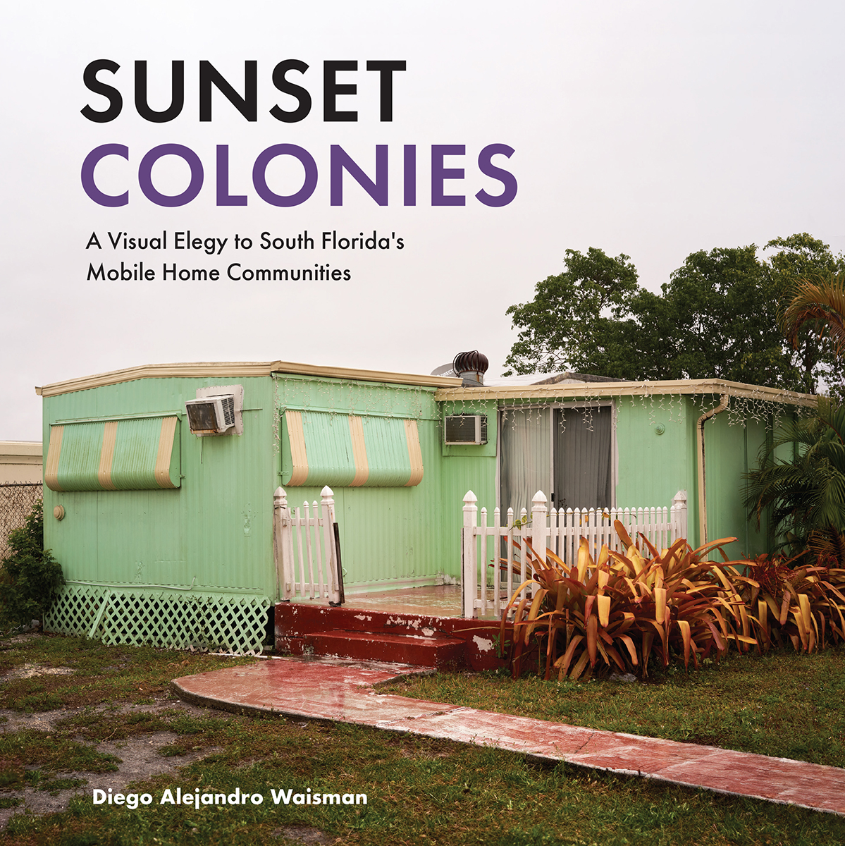
The erasure of the Simonton Street Trailer Park contains a pointed message about place and identity that forms the intellectual core of Sunset Colonies: A Visual Elegy to South Florida’s Mobile Home Communities. The book centers on the photography of Diego Alejandro Waisman, an Argentine by birth but a resident of Miami for over two decades, where he has established himself as a visual artist dedicated to the discontinuities and disfigurements caused by the sybaritic excess of South Florida. Waisman writes of using the “vernacular” of place to inform his work, and in the vanishing trailer parks of Miami, he has found a trove of distinctive tones.
The data is clear: the mobile home as a mode of domicile has decreased in Florida over the past decade, falling from 9.2 to 8.2% of all housing in the state. Yet unlike Tampa or St. Petersburg, the trailer park was never a defining feature of Miami, with just 1.3% of housing units being mobile homes–a figure that has remained stable over the years.3“Mobile Homes (Census ACS), FLHealthCHARTS, https://www.flhealthcharts.gov/ChartsDashboards/rdPage.aspx?rdReport=NonVitalIndRateOnly.Dataviewer&cid=0408, accessed August 24, 2025.
Waisman’s work directly takes on a persistent stigma that has plagued mobile homes from the beginning: the concept of “trailer trash,” a term that dates back to the 1950s as a way to condign residents of trailers to the ashbin of humanity. It’s certainly easy to bulldoze down a trailer park if conventional wisdom has it that the place was filled with lowlife scum.4 Harold H. Martin, “Don't Call Them Trailer Trash,” The Saturday Evening Post, August 2, 1952, Vol. 225, No. 5.
But Waisman is looking for “evidence” that even within these marginalized places, meaning and purpose can take on a multitude of forms and shapes. The photographs themselves come from his collection, For I Shall Have Already Forgotten You, a line taken from “If You Forget Me” by Pablo Neruda, a poem that appears in reprint like a miracle after the last photograph and thus lands like a thunderclap of grim profundity. Seldom has a title, poem, and art flowed together with such urbane felicity.
While Neruda in the poem might’ve been referring to a lover or to his native Chile, it’s clear that Waisman is fueled by the poem’s pervasive feeling of loss and longing. It begins: “I want you to know one thing.” Waisman takes up that same charge and then uses his camera to capture “everything that exists” within the vanishing world of Miami’s trailer parks.

The unique geometry of Waisman’s work flows from his use of juxtaposition, the constant tension between old and new that in Miami sees skyscrapers arising next to thousand-year-old Tequesta sites. Waisman’s eye for such incongruity takes many forms in his collection. One arresting image features in the foreground a well-tended double-wide of white planks and blue trim while in the background a monstrous banality of rebar rises as if to devour the trailer in one rapacious gulp. Given the demise of the Simonton Street Trailer Park, it’s reasonable to conclude that in time too this landscape will get subsumed by the "predatory capitalism” described as the casus belli of gentrification by anthropologist Louis Herns Marcelin in his fine Afterword.
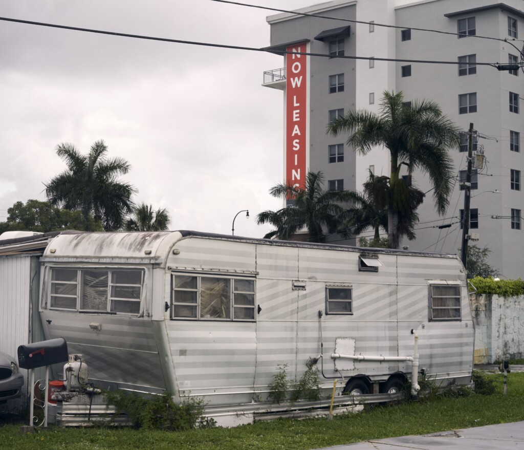
Other works also play with the tension between old and new. Sometimes the reference juts into the composition like an interloper (below), such as how he centers a “Now Leasing” sign jabbing like a dagger into the belly of a home—this work reads like an act of violence, a needless and wanton gesture of dominance.
In another, the new building remains to the far right edge, rising up into the sky with a defiance that borders on mockery. The helpless trailers can do nothing but accept this fate, a finality rooted in a dream of Florida that is in open conflict with the grinding truth.
Then, in works that are somber and soulful, Waisman follows the fervid logic of Growth to its deflating conclusion: a scattering of pieces just depict the new environment with the trailer parks completely gone. Another condo project is taking shape, and on the fence surrounding it hangs a festoon of fiction, happy older couples frolicking care-free. The condo being built has no personality, no sense of self, and stands in stark contradiction to the very idiosyncratic decorations of trailers, no two of which are the same.
Waisman explores lines with great precision, finding unique ways to capture how segments can align to produce meaning. For example, in one photograph, the horizontal lines of jalousie windows stand perpendicular to the vertical lines of a metal post and door frame. Both then seem to merge with criss-cross lattice, as a clearly delineated triangle of shade falls across the trailer. The “evidence” here is of the evanescent sort: as South Florida booms, the most vulnerable places must stand in quiet opposition, affirming their own nuance in subtle ways that Waisman’s camera can singularly capture. He has spoken of his photographs as a way of slowing down the gathering decimation of these communities. His work forces us to stop, look, and ponder where exactly the American experiment is headed.

Beyond the geometry is a pulsing humanity that suggests the work of Andres Serrano, whose Residents of New York series from the 1990s conveyed the enduring spirit of Gotham’s unhoused. Waisman’s trailer park dwellers are certainly housed, but in effect his portraits are a kind of memento mori, a moment in time that will not last.
The man holding the cigarette, how long can he make it before the wrecking ball comes for the entire park? And when it’s gone, where will he go? The lattice here serves more like a net that the subject is caught in–that has ensnared all of us. His expression, though, speaks to a consanguinity, a softness that belies the other ravages the man has endured. Here Waisman is playing with juxtaposition again, but this time the viewer must enter this conversation, must hear the man out. There’s no turning away.

And the trailers . . . Waisman has assembled a wide array of examples, using an expansive color palette to capture the distinctive hues of the region. Lime greens, cerulean blues, and cherry reds all speak to the allure of South Beach, yet without the glitterati and glam. Some of the trailers have been lovingly landscaped, while others sit on bare concrete. Some are in pristine condition, and others display repairs that have accreted over time, in clunky layers of rust. Many have their hurricane shutters drawn shut, as if the corrugated metal can’t bear to witness the impending doom.
In addition to the trailers and the people in them, Waisman has added a wrinkle: photographs of ads that ran in newspapers during the 1960s and 70s, all of which extol the virtues of these communities. This is yet another kind of juxtaposition, this one ironically cultural. Waisman rightly views the backstory of trailer parks with a raised eyebrow. Why did so many people work so hard to attract retirees to Florida only to castigate and then obliterate these very communities when they are needed the most? Waisman’s splashes of history are bracing, cold water applied to smug faces. He is suggesting that there used to be a world where lower-income people could live in affordable housing–and a world where Florida led the way in pioneering an alternative to gaudy McMansions. It wasn’t even that long ago, and yet Waisman demands us to answer: what happened?
Waisman isn’t on the prowl for good guys and bad guys. He’s not offering an answer, because artists don’t answer questions, but ask them. And the question is often some variation of Thales: why is there something rather than nothing? What huge forces are shaping the landscape? The key to this collection resides in the title: it’s an “elegy,” visual lament to the dead, the dearly departed cut down by a market-driven mania to maximize profits at the expense of the unfortunate. But Waisman lifts these dead upwards so that we can celebrate the dignity these hardscrabble people display.
Three other essays complete Sunset Colonies. Amy Galpin’s helpful Introduction establishes an academic perspective for assessing Waisman’s collection. Her essay serves as a kind of map that adds context to the photographs that follow. Without Galpin, Waisman’s pieces might come off as a random assortment that could be befuddling.

But what Waisman is doing, very cleverly, is exploring the dynamics of “trailer trash” that has tarnished this community from the beginning. He is exploding this framework by offering a deeply human look at the “trash” whose lives are imperiled by the rampant development that caters to the well-off. The portraits of the residents and their homes speak to the enduring struggle to maintain even as the world seems to be crumbling around them. One image haunts, that of broken sidewalk tile, an apt metaphor for what Waisman has catalogued: the bombardment of a community that will end in permanent exile. 
About the Author
Lee Irby's peer-reviewed publications include works of history, fiction, and poetry. His study of "trailer-trash" culture has received numerous awards, and his novel 7,000 Clams (Doubleday, 2005) was named by the Tampa Bay Times as one of the "10 Books Every Floridian Should Read."
]]>Introduction
What role does cruising play in marking specific areas of the urban landscape as "queer territory"?1For the purposes of this essay, I use the word "queer" primarily in its capacity as a contemporary umbrella term intended to include the panoply of non-normative sexual and gender identities concatenated in familiar and unpronounceable acronyms like LGBT, LGBTQ+, and LGBTQQIAA. To be sure, other speakers and thinkers deploy "queer" with additional senses—an historical term of derision, a specific identity, a verb. The word can summon all these thoughts and more, regardless of authorial intention; indeed, it can carry whatever freight we readers bring to it. When I intend these specific meanings in this text, I will do my best to flag them. In general, I argue our politics and communities benefit most when we embrace the untidy polysemy of "queer" and explore the openings it provides. Since the 1970s, social scientists have proposed and critiqued various models of queer territorialization. Martin Levine used spot maps of bars and cruising grounds to substantiate a "gay ghetto"; Jen Jack Gieseking analyzed individuals' "mental maps" of queer space; Amin Ghaziani critiqued the enclave theory of "gayborhoods" in favor of what he terms "cultural archipelagos."2Martin Levine, "Gay Ghetto," in Gay Men: The Sociology of Male Homosexuality, ed. Martin Levine (New York: Harper and Row, 1979), 196–218; Jen Jack Gieseking, "Queering the Meaning of 'Neighbourhood': Reinterpreting the Lesbian-Queer Experience of Park Slope, Brooklyn, 1983–2008," in Queer Presences and Absences, eds. Yvette Taylor and Michelle Addison (London: Palgrave Macmillan, 2013), 178–200; Amin Ghaziani, There Goes the Gayborhood? Princeton, NJ: Princeton University Press, 2015; Amin Ghaziani, "Cultural Archipelagos: New Directions in the Study of Sexuality and Space," City & Community 18, no. 1 (2019): 4–22. All these models of queer territory posit collective understandings of place that transcend the social boundaries of queer identity groups.
All three authors also reference cruising, but offer little detail about how cruising works in their models. Using the city of Houston as an example, this essay attends to cruising as an underdeveloped aspect of those models. As Houston's Montrose neighborhood came to be identified as a "gayborhood" between 1960 and 1980, archival evidence shows that cruising narratives played a powerful role in that identification. At the same time, these narratives also show that queer territorialization in Houston was not a smooth process of collective place claiming and recognition. Rather, dissent and conflict over the practice of cruising in Houston shows queer place claiming to be fractured, contested, and structured in part through a politics of respectability inflected explicitly by class but curiously silent on race. Importantly, that fractured and contested structure is due in part to the converging efforts of a wide array of disparate agents: queer sex-seekers, Houston residents, local politicians, civic groups, queer organizations, national anti-pornography groups, and conservative political movements. These narratives also point to complicated relationships between cruising and other markers frequently used to define queer territory, specifically businesses serving a queer clientele.
Cruising: Practice and Concept
Cruising takes the art of the flâneur—passing time watching people, usually in public—and imbues it with the additional potential or explicit purpose of finding a sex partner. As Alex Espinoza has evocatively described, cruising can lead to sex in situ, whether in public locations like parks or semi-public locations like restrooms, but often leads to sex elsewhere in more private spaces.3Alex Espinoza, Cruising: An Intimate History of a Radical Pastime. Los Angeles, CA: Unnamed Press, 2019. It can also happen inside commercial establishments that charge a fee to access other clientele in a semi-private space, like bathhouses, video arcades, and adult book stores. Out of doors, cruising can happen both on foot and, after the popularization of the automobile, by car as well. Cruising is also associated strongly but not exclusively with gay men. In our information age, dating websites and hookup apps on mobile phones—Grindr, Scruff, Growlr, Boyahoy, Jack'd, and others—seem to remove much of the guesswork (but definitely not all the danger) from divining who might be nearby and looking for the same thing. Many men seeking men for sex today came of sexual age through these digital tools, leading writers like John Fielding to ask whether the prominence and distribution of cruising as a queer social practice has waned as a result.4"In the Age of Grindr, Cruising and Anonymous Sex Are Alive and Well," Vice, January 7, 2016, https://www.vice.com/en/article/qbv5n3/cruising-in-the-age-of-grindr-828.
While this essay centers upon the importance of cruising in a particular place and a past era—Houston between 1960 and 1980—the rich scenes it describes should not be misconstrued to suggest that cruising is a thing of the past. Rather, contemporary popular culture, high art, literature, pornography, and vernacular speech continue to reproduce face-to-face cruising in public as part of a globally available gay sexual vocabulary and social practice. Espinoza's Cruising movingly shows the practice is not of a bygone era or one in which only certain (morally questionable) people engage. His book has received critical acclaim in part for its temporal and global scope—ancient Greece, England, Russia and Uganda receive specific attention—but also for his sensitivity both to disability and Latinx experience, as well as his assertion that cruising can offer contact across class and racial lines. That assertion echoes Samuel R. Delany's analysis of cruising in New York as a form of "contact" in Times Square Red, Times Square Blue (1999).5John Birdsall, "Review: 'Cruising' maps the cultural history of L.A.'s hookup spots," Los Angeles Times, July 3, 2019, https://www.latimes.com/books/la-ca-jc-review-cruising-alex-espinoza-gay-history-20190703-story.htm. In short, cruising persists as a culturally relevant practice in the United States and elsewhere, one that often moves across social boundaries and identity categories.
Men seeking men for sex has never been the sole determinant of queer territory. For those who know how to read it however, both then and now, cruising marks public and semi-public spaces as at least temporarily queer(ed) territory. This marking is how cruising functions not only as a social practice but also as a concept. Through documenting the disparate networks of people who came to meet on Houston's cruising grounds—intentional sex-seekers, criminals exploiting stigmas attached to gay sex, ambivalent law enforcement officials, area denizens, and perhaps initially naïve passersby—I argue that the social distribution of knowledge about cruising illustrates that queer territories functioned in part because some who do not identify as "queer" also imagined those territories as connected to queer lives.
This distributed social knowledge is the kind of information that Levine described under "culture area," that Gieseking captured through "mental mapping," and that Ghaziani articulated through his concept of the "cultural archipelago." Although similar in emphasis, these theorists differ significantly in how they imagine the process of place claiming. Levine borrows four criteria from the sociologists Robert Park and Louis Wirth to assess the status of a "gay ghetto": institutional concentration, culture area, social isolation, and residential concentration. Levine mapped bars and cruising areas listed in Bob Damron's 1976 Address Book to illustrate institutional concentration, and conducted a literature review and "exploratory fieldwork" in those concentrated areas to assess the remaining three criteria.6Levine, "Gay Ghetto," 185. His "exploratory fieldwork" consisted of walking around neighborhoods observing gay life and talking with gay people, activities quite parallel to cruising itself. Particularly in his assessment of culture area, Levine describes a remarkably smooth process of place claiming. Within the culture area, "open displays of affection [between men] rarely evoke sanctions; for the most part, people either accept or ignore them. Even police patrols through these spaces pay little attention to such behavior. . . . In other places, such behavior quickly elicits harsh sanctions."7Levine, "Gay Ghetto," 204.
By contrast, Gieseking and Ghaziani attend more closely to a multiplicity of perspectives, change over time, and conflict in social descriptions of place. Gieseking defines mental mapping as "the representation of an individual or group's cognitive map" of a specific place.8Jack Jen Gieseking, "Where We Go From Here: The Mental Sketch Mapping Method and Its Analytic Components," Qualitative Inquiry 19, no. 9 (2013): 712. While most of Gieseking's work is credited as "Jen Jack," this article flips those names. In visualizing both multiple individuals' and group perceptions' of a place, Gieseking finds that mental sketch mapping can "afford participants and researchers alike a way to share and see more multidimensional stories of themselves and their experiences through the lens of space and place."9Gieseking, "Where We Go From Here," 723. For his part, Ghaziani observes that "new residential and leisure queer spaces are forming across the city, and beyond its borders as well." That multiplicity of spaces grounds his proposal "that we redirect the study of sexuality and space away from our preexisting assumptions of spatial singularity—evinced by a steady stream of publications about individual gay districts—toward a cultural archipelagos model of spatial plurality."
Although Levine's work gives an important foundation, the history of cruising in Houston more closely exemplifies the social dynamics Gieseking and Ghaziani describe. During the twenty-year span centered on the 1969 Stonewall riots in New York, cruising narratives in Houston exhibit a multiplicity of opinions about a multiplicity of spaces, even as public awareness of the Montrose neighborhood as "gay" solidified both locally and nationally. This essay analyzes mainstream and queer sources of the time to construct and juxtapose two datasets: a GIS-enabled mapping of historical queer business data and an archive of narratives of cruising. While the business data offer one visualization of queer territory in Houston, narratives of cruising exceed the capacities of that mapping. Cruising areas have complex relationships to commercialized spaces—sometimes directly connected, at other times peripheral and symbiotic, and at others seemingly divorced. At the same time, these seven cruising narratives I feature here illustrate that efforts to regulate cruising converge from multiple, conflicting sources, including queer newspapers and community10Like "queer," "community" is also a freighted word. While I use it in this essay as a shorthand, I encourage readers to be cautious about the degree of coherence, agreement, organization, and unity they take it to convey. organizations with a range of stances toward queer life.
Mapping Queer Houston
I first came to live in Houston in 1997. When I arrived, the Montrose neighborhood was the epicenter of a thriving queer community. It was home to the largest concentration of Houston LGBT bars as well as many non-profit organizations, from the Montrose Counseling Center to Pride Houston. There were two queer bookstores, a free monthly magazine, and several free weekly papers. Soon, I was working for one of those papers, distributing copies all over the city. That labor helped me question and reimagine my first assumptions about the distribution of queer life in Houston. In this car-addicted place, queer bars and businesses were not just in the trendy Montrose neighborhood, but in far-flung suburban strip malls as well. Even so, Montrose remained the symbolic core.
That was not always the case. In 1911, J. W. Link and his business associates platted and marketed the Montrose Addition as an upscale suburb for middle- and upper-class Houstonians to escape the dirt and heat of the urban core. The Link Mansion built at the corner of Montrose and Alabama streets to advertise the new neighborhood was for some time the most expensive private home in Houston. To understand better how Montrose shifted from that elite suburb to a "gayborhood," I began a project in 2014 inspired by Levine's spot maps. I built a database of over 400 historical queer businesses11The definition of "queer business" here deserves some nuance. The database captures businesses explicitly marketed to a queer clientele. Historical queer advertising usually depicts that clientele as gay men and lesbians, often but not always as separate populations rather than a single market. Businesses were included in the database if they advertised in a Houston-based publication aimed at a queer readership or appeared in a national directory such as Damron's Address Book. This is not to say that queer community owned each business or that queer community was the only clientele. This nuance also matters when thinking about the relationship of cruising to commercial space, whether or not that commercial space can be thought of as queer. identified in Houston's historic queer publications like The Albatross, The Nuntius, and This Week in Texas, and supplemented those publications with other historical sources. I cross-referenced these locations through Houston's city directories to confirm the length of time each business was in operation at every street address given for it. Some bars relocated, for example, often after a fire. Using ArcGIS, I visualized that database from 1941 to 2015 on a contemporary base map of Houston to help orient present day viewers. Finally, I sequenced the 74 maps into a short animation.[2] 12Brian Riedel, "CSWGS Where is LGBTQ Houston?" YouTube video, 3:15, March 15, 2018, accessed December 31, 2019. https://www.youtube.com/watch?v=baSgYQtkTSI&feature=youtu.be&ab_channel=RiceUniversity. This animation was also displayed at Houston's Heritage Society in 2015 as part of the six month installation "Throughout: Houston's GLBT History."
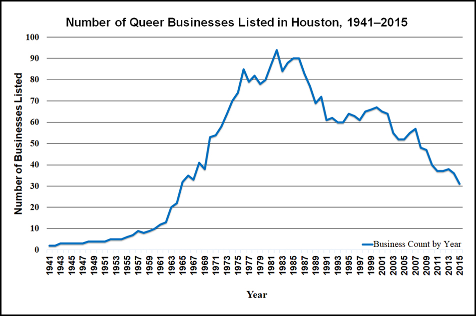
That animation suggests several phases to describe Houston's queer geography and history, phases that can also be visualized through a graph of businesses over time (see graph below). From 1941 to 1955, most businesses catering to queer community (though often not exclusively) operated in downtown, present-day Midtown, or the Rice Village area. The first location in Montrose was Art Wren's, a diner that ran from 1956 to 1971. Art Wren's also gained a national profile; it is one of nine "interesting" Houston locations listed in a 1962 souvenir program of the League for Civil Education's drag fundraiser in San Francisco, "Michelle International."13"Michelle International," League for Civil Education, accessed December 31, 2019, https://www.queermusicheritage.com/fem-michelle.html. Of the nine locations listed for Houston, I have been able to confirm locations for six. Beyond those six, I can confirm an additional seven locations not included in the souvenir program. That Art Wren's is among those six speaks further to the strength of its reputation. Here, "interesting" served as code for "gay"; the words "gay" and "homosexual" never appear in the League's program, even though the drag event raised money to help those arrested in raids on gay bars. By 1969, Houston's queer center of gravity was clearly shifting toward Montrose, but Midtown and downtown were still quite active. By the 1980s, the intersection of Westheimer Street and Montrose Boulevard was the center of queer life in Houston, and new bars and businesses began opening further west and into suburban areas. Even as the geographic distribution of queer spaces widened, the total number of locations peaked at 94 in 1982. During the 1980s, Houston endured the double impact of HIV/AIDS and the long economic fallout of the 1981 oil bust. The number of queer businesses began to stabilize at around 60 in 1991, but would begin dropping again at the turn of the twenty-first century. Montrose remained the dominant center as that number continued to taper. In 2015, just 31 businesses were operating, fewer than Houston had at the time of the Stonewall Riots.
Helpful as it is for visualizing change in queer Houston over time, this mapping project has significant limitations for the kinds of queer community it can be assumed to depict. Just at the level of "queer businesses," a mafia-owned bar with a partially queer clientele in the 1950s is not exactly the same kind of queer business as a lesbian-owned bar in the 1980s that hires a security firm to watch the parking lot.14See "Kindred Spirits," Houston LGBT History, accessed October 1, 2020, http://www.houstonlgbthistory.org/misc-kindred.html. While such a 1950s bar could be any of those Carl Wittman laments in his "Gay Manifesto," the 1980's bar I mention here is quite specific. Marion E. Coleman started Kindred Spirits in Houston as an answer to many lesbians' problems with the bar options then available. She also hired a security firm to guard the parking lot and screen customers. Also, attending only to bars and businesses can skew our perception of queer space along class-inflected lines; professional middle-class and upper-class lesbians and gays eschewed the bar scene as dangerous for some time, even as recently as the 1990s.15See the letter writer to ONE below. In Houston, that pattern structured the Dianas, an almost exclusively white, upper-middle-class social organization of mostly gay men that originated in 1953 as an Academy Awards watch party in a private home.16"History of the Diana Foundation," Diana Foundation, accessed December 31, 2019, https://thedianafoundation.org/page/history-of-the-diana-foundation. That same pattern of discretion also influenced the creation of the Executive and Professional Association of Houston, founded in 1978.17"The Executive and Professional Association of Houston," EPAH, accessed December 31, 2019, https://www.epah.org/. In the more than 300 oral histories gathered through the Old Lesbian Oral Herstory Project, many lesbians—particularly those in middle-class professions like nursing and teaching—preferred softball and house parties to bars as ways to meet other women.18"The Old Lesbian Oral Herstory Project," OLOHP, accessed December 31, 2019, https://olohp.org/index.html. OLOHP owes a great deal to Arden Eversmeyer who trained women to collect oral histories across the United States. I am also indebted to an anonymous reviewer for bringing my attention to The New Orleans Dyke Bar History Project, accessed October 1, 2020, http://www.lastcallnola.org/. Those oral histories document a different perspective: some lesbians in 1970s and 1980s New Orleans preferred to meet each other in bars. See also John Howard's edited volume Carryin' On in the Lesbian and Gay South (New York: NYU Press, 1997). Mapping bar locations sourced in a mostly white-oriented gay press also elides Black, Indigenous, and other People of Color, along with their specific networks and practices.19For example, see see E. Patrick Johnson, Sweet Tea: Black Gay Men of the South, (Durham: University of North Carolina Press, 2011) and Black. Queer. Southern. Women. (Durham: University of North Carolina Press, 2018).
Beyond these limitations, the academic literature on queer territory also suggests the animation should account for the role of cruising as a place-claiming practice. Levine specifies cruising as a form of "institutional concentration" in his model of the gay ghetto, and even symbolizes cruising areas on his maps.20Levine, "Gay Ghetto," 1979. Levine also discusses cruising in chapter 4 of Gay Macho (New York: NYU Press, 1998). However, they appear as static present entities; he does not inquire into their pasts or their futures. Gieseking also positions cruising as one element in the creation of queer territory21Jen Jack Gieseking, "A Queer Geographer's Life as an Introduction to Queer Theory, Space, and Time," in Queer Geographies: Beirut, Tijuana, Copenhagen, ed. Lasse Lau et al. (Roskilde: Museum of Contemporary Art, 2013), 4–21. but takes care elsewhere to mark the limitations of both cruising and any emphasis on territory for the analysis of women's communities.22Gieseking, "Queering the Meaning of 'Neighbourhood,'" 2013. Ghaziani's There Goes the Gayborhood? briefly mentions cruising, framing it as an activity that could occur in any number of venues in the urban landscape.23Ghaziani, Gayborhood, 13. Ghaziani redeploys that same formulation of cruising in a more recent essay while arguing for "a cultural archipelagos model of spatial plurality" as an antidote to "enclave thinking." He argues that "the spatial expressions of sexuality are becoming more diverse and plural."24Ghaziani, "Cultural Archipelagos," 7. Though my mapping project did not visualize cruising areas, the research behind it did surface many narratives of cruising. Analyzing these cruising narratives in parallel with the mapping project, I argue that together they offer strong evidence to support Ghaziani's archipelagic model of queer territorialization in Houston at various moments across the twentieth century. Rather than any single enclave as figured in the footprint of Montrose, for example, these seven cruising narratives point to multiple, contested queer territories spread across Houston in memory and practice.
1930s: "Window Shopping"
The Houston queer press archive offers glimpses of cruising practices and mental maps that pre-date the temporal frame of my mapping project (1941–2015). In a 1988 article from the Montrose Voice,25"Montrose Voice," University of Houston Digital Libraries, Houston Texas, accessed October 1, 2020, https://digital.lib.uh.edu/collection/montrose. The Montrose Voice was published in Houston from 1980 to 1991. For readers unfamiliar with Houston's queer press history, I strongly recommend browsing the JD Doyle Archives, accessed October 1, 2020, http://www.jddoylearchives.org/. Richard Van Allen relates stories from men who lived in Houston before World War II, and recounts a queer urban geography through their eyes:
"The 'gay circuit'—they didn't know the word 'gay'—was downtown Houston, between Franklin and McKinney and Main Street east to San Jacinto. You could not tell a queer or a fag (the words they used then) from the straight, which was the way the gays wanted it, being fearful for their lives and jobs."26Richard Van Allen, "Houston's Gay Thirties," Montrose Voice, no. 410, September 2, 1988: 9. https://digital.lib.uh.edu/collection/montrose/item/8166/show/8130. This article has echoed in Houston media since then. See also William Michael Smith, "Looking Back at Some of the Hurdles Houston's Gay Community Had to Overcome (Part 1)," June 20, 2014, http://www.houstonpress.com/news/looking-back-at-some-of-the-hurdles-houstons-gay-community-had-to-overcome-part-i-6736836; "Houston's Earliest Gay scenes (Part 2)," Houston Press, June 23, 2014, http://www.houstonpress.com/news/houstons-earliest-gay-scenes-part-2-6748546; "'The Homosexual Playground of the South' (Part 3)," June 24, 2014, http://www.houstonpress.com/news/the-homosexual-playground-of-the-south-part-3-6737870.
Aside from a few bars that, while not intentionally or exclusively gay, served as gathering spaces to those in the know—the Rathskeller, the Old Vienna, the Capitol Bar, Rex's27Sadly, Houston city directories from the 1930s and 1940s did not confirm the addresses and locations for the bars documented in this article, so they are not included on the map. It is tempting to assume they fall within the sixteen-block area described by Van Allen.—what then functioned as queer "territory" was out on the street in that sixteen-block rectangle. According to a man Van Allen calls Dan:
"Of course, we didn't know the word 'cruising' then. We called it 'window shopping' and just like now, you know who was gay and who wasn't without asking. You could feel it, whether they had a limp wrist or not. There was this post down in front of Levy's department store. It had mirrors on four sides, and queers would stop and comb their hair there. Oh, you could spot them. If we did want to trick, we could get a room at the Milby or the Texas State Hotel. More often we went home to our apartments."
Much as Ghaziani describes "the closet era" of "scattered gay places"28Ghaziani, Gayborhood, 12–13. Ghaziani credits the second phrase as Ann Forsyth. prior to World War II, Dan's recollection of imagined gay space is opportunistic rather than exclusive. The social ecosystem of commercial downtown spaces—semi-public bars, shop windows, mirrored posts, and semi-private hotel rooms—created opportunities for strangers to meet for sex while providing a degree of plausible, respectable deniability. Gay networks circulated in parallel with other networks, but at least in Van Allen's account, cruisers would often move across the city landscape to more private spaces after meeting in more public ones.
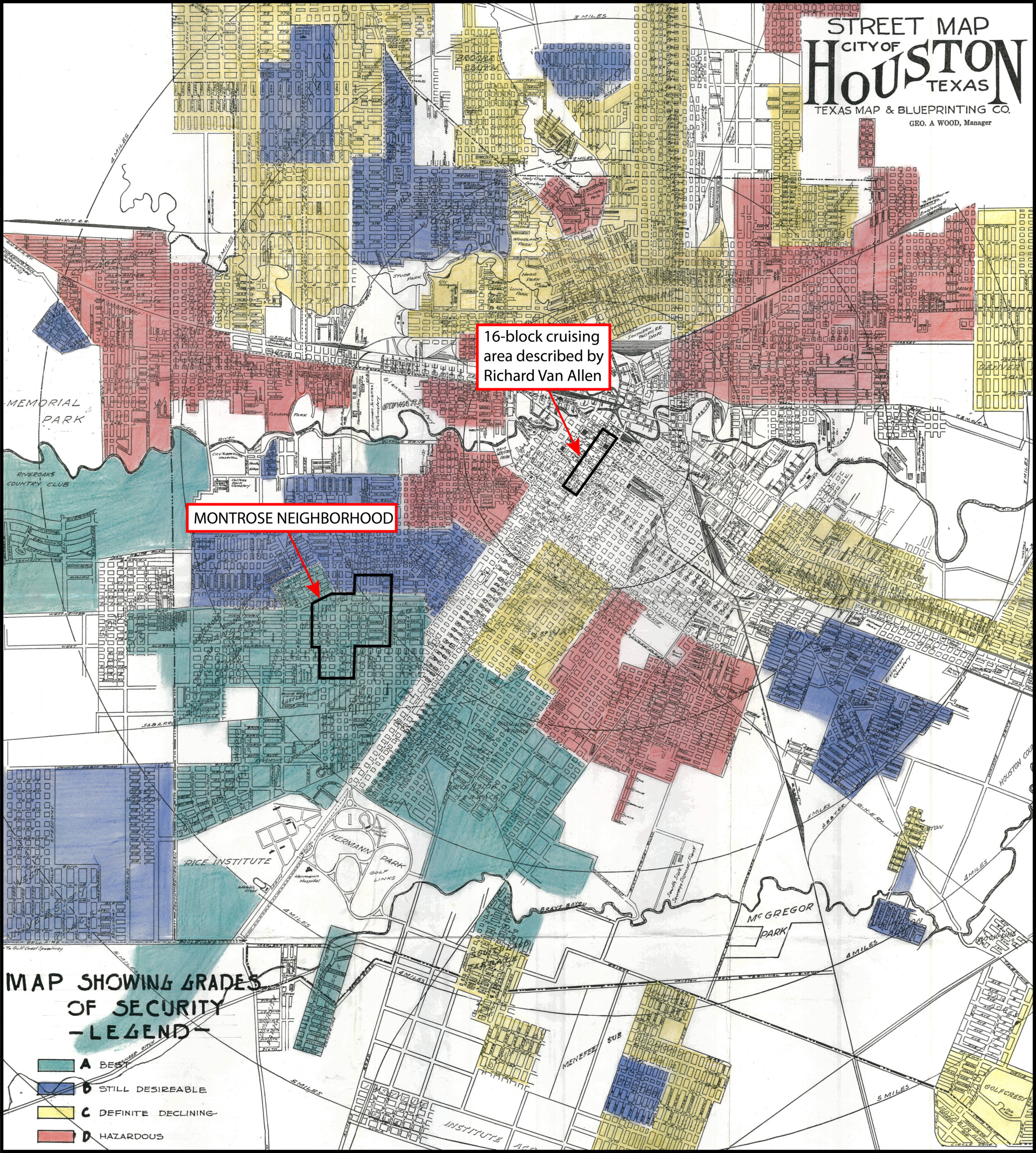
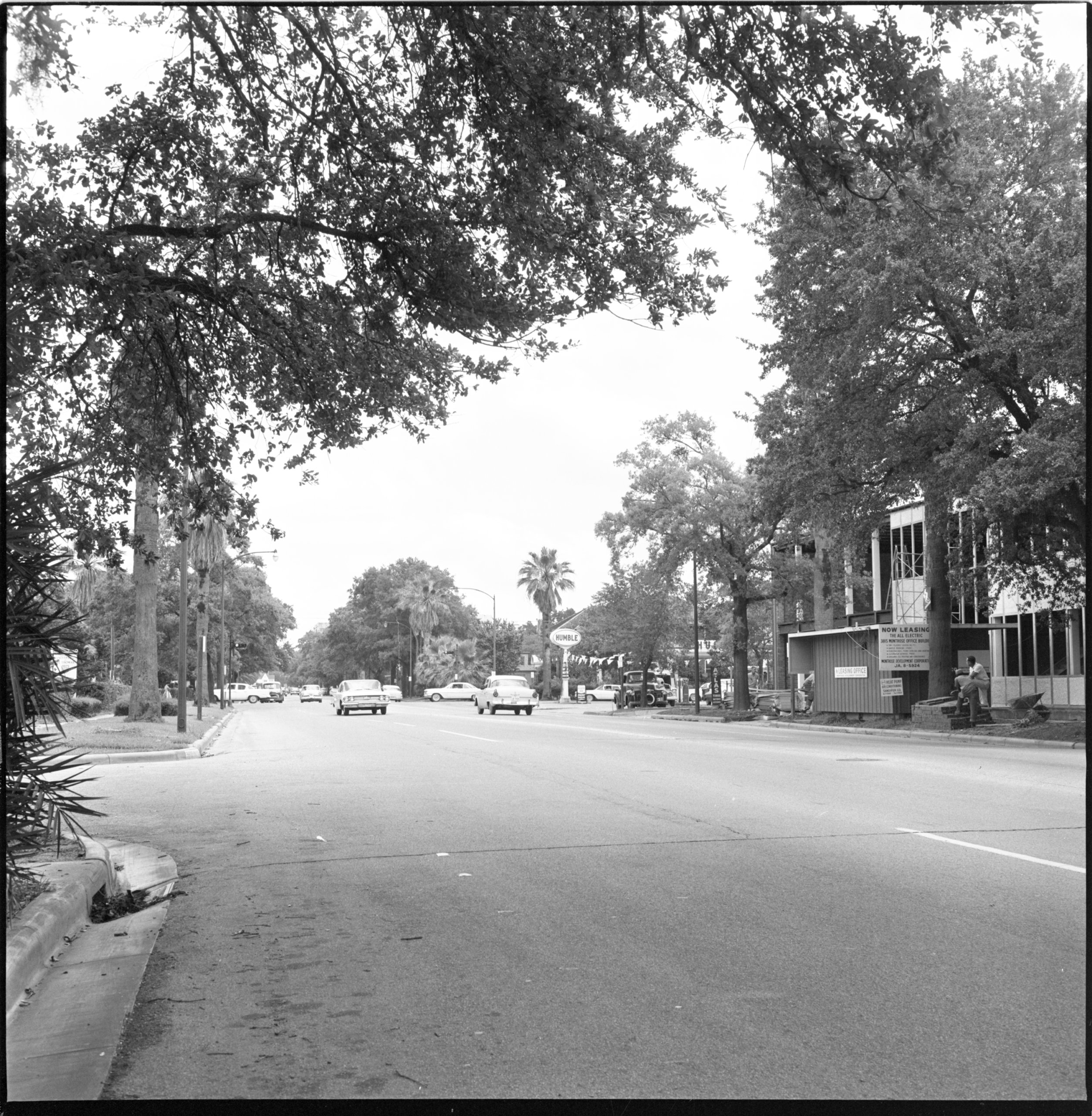
A striking way to situate this "window-shopping" area and the Montrose neighborhood in relation to the rest of 1930s Houston is to superimpose them on a now infamous Home Owners Loan Corporation map from the same era (see map above). The areas shaded red indicate the "hazardous" parts of town, where Black residents tended to live, and where the Home Owners Loan Corporation would not insure mortgage loans. The Montrose neighborhood, some two decades old at the time of this map and mostly shaded green, was the "best" type of neighborhood in which to live. Situated at the city's commercial core, the sixteen-block cruising area Van Allen's article described may well have provided opportunities for same-sex contact across both class and racial lines. And yet, Van Allen's narrators never mark race in their stories. The redlining map suggests at least one explanation for that absence, one that complicates any quick analogy to the kind of racial mixing found in Espinoza's memoir: the opportunistic use of public and semi-public spaces for cruising relied on an appearance of respectability that accounted for the persistence of racial as well as sexual lines in Jim Crow Houston.
1963: A Letter to ONE
From the 1940s through the early 1960s, however, the commercial spaces for queer community in Houston became less opportunistic and more intentional. Take for example a May 23, 1963 letter a Houstonian sent to the nationally distributed gay homophile magazine ONE,29ONE Magazine, ONE Archives at the USC Libraries, Los Angeles, 2018, https://one.usc.edu/archive-location/one-magazine. The magazine ONE was published in California from 1953 to 1967 and distributed nationally. It was the subject of the landmark 1958 US Supreme Court decision ruling that pro-homosexual writing was not of itself obscene. in which the writer offered his perspective on gay territory in the city:
Gay life in Houston seems relatively trouble-free as nearly as I can tell from my somewhat aloof perch (I don't patronize bars or attend parties or socialize much). A newly opened bar a few blocks distant is attracting great crowds on the week ends, with cars parked for blocks around, and always police watching especially toward closing time. The gay folks I meet seem delighted, and gloomily prophes[ize] that it is too good to last—I haven't heard of any trouble so far, though. Percentage-wise it seems to me this area has fully as many gay folk as any area in any of the larger cities in the North and West. Don't know of any other part of Houston where gay life is concentrated, though, except for a cheap theater downtown where the rough trade operates in amazing quantity and frankness—but could hardly call that gay life!30Craig M. Loftin ed., Letters to ONE: Gay and Lesbian Voices from the 1950s and 1960s (New York: SUNY Press, 2012), 114–5. To his credit, Loftin preserves the privacy of these letter writers by masking their precise addresses and substituting pseudonyms for their names.
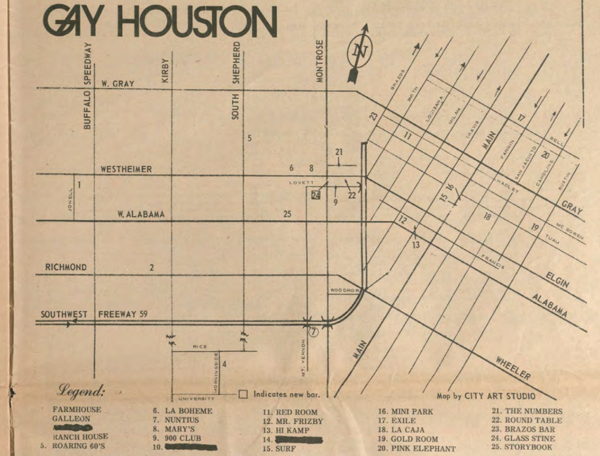
While the writer's self-described "aloof" lifestyle may constrain our estimation of his version of events, the details he provided remain evocative. He spoke to a consciousness that "gay life" could be concentrated, perhaps even that it should be so organized. He also seemed to see himself as living in that concentrated part of town; he did not "know of any other part of Houston where gay life is concentrated" (emphasis mine). Still, he recognized a larger bar scene, though he did not attend it. (The map below provides a visualization of the bars and other businesses of which the writer might have been aware in 1963.)
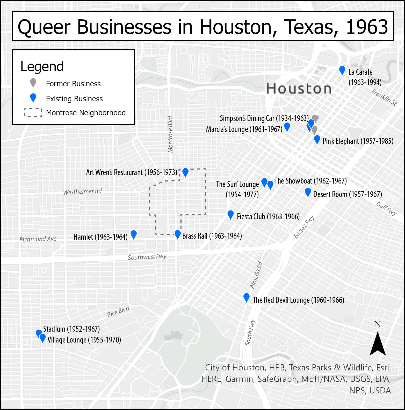
The letter also captured the writer's sense that, for its size, queer Houston was not so out of step with the larger cities of the "North and West." New York, Chicago, San Francisco, and perhaps Los Angeles were his likely referents. Given the date of his letter and his description of a recently opened and wildly popular bar, it is also likely that his referent was Bob Eddy's Showboat, opened in 1962 on Tuam Street in present-day Midtown (labeled on the map above). For the writer, cruising was a primary if ambivalent index for whether "gay life" was "concentrated" in a particular location. The "cheap" theater he referenced is challenging to specify today given the lack of detail. I have yet to find an advertisement or mention of such a downtown theater in the queer press archive of the time; perhaps its rough trade reputation circulated only through hearsay. Whatever theater it was, the letter clearly shows that as late as 1963, this author's imagination of queer space in Houston was explicitly linked to present day downtown and Midtown. Montrose did not figure in his letter at all, even though Art Wren's had operated there for about seven years and had in 1962 already appeared in a local publication in California.
Another key index for the writer's imagination of gay life comes in the phrase "rough trade," a term still in use today. Then and now, the "rough" of "rough trade" signals men whose affect and physical appearance are both more working-class and more masculine—men who are not just "straight" acting and appearing, but who also might actually be more dangerous to approach, though that risk might itself be part of the thrill of approaching them. "Trade" signals that these men may, in fact, see themselves as straight, and that they could be only "dabbling" in same-sex activity. It also signals that these men might be seeking male clients in exchange for money, regardless of their or their client's sexual preferences. The writer to ONE gestured to this sexual ambiguity of "rough trade" when he divorced the downtown scene from what he called "gay life." At the same time, we might wonder how the writer himself was aware of the theater scene. He may have participated in it, at least enough to know just how abundant and frank the rough trade was. In any event, he does not disclose how he came to have that knowledge, even in the pages of a homophile magazine.
Importantly, the writer is also silent on the subject of race, a silence that suggests Jim Crow culture continued to texture both "gay life" and "rough trade" in the 1960s just as it had "window shopping" in the 1930s. At the same time, respectability politics are both explicit and implicit in his "aloof" observations. He marks the scene around the newly opened bar with cars "parked for blocks" and patrons who presumably have disposable income to spend at a bar, all signs pointing toward respectable middle-class status. By contrast, the "rough trade" scene at the "cheap" theater points to lowbrow entertainment and potentially sex work; their "amazing quantity and frankness" also signals their divergence from middle-class respectability.
1965: The "Phantoms" of Avondale
By 1965, however, Houston's locally produced queer press offers suggestive evidence that cruising areas had begun to shift into the Montrose neighborhood. One such piece ran in the first issue (1965) of the short-lived gay periodical, The Albatross.31"Who Are the 'Phantoms' of Avondale?" The Albatross, August 18, 1965, 1. All seven issues of The Albatross were published between 1965 and 1968 in Houston by Bob Eddy, the first owner of the Showboat bar.
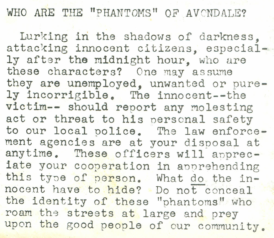
The text is an intriguing window to the mise en scène of Montrose at the time. It appeared on the first page of The Albatross, marking the editors' sense of its importance with that placement. The text calls its readers to act, to report to the police crimes that the text assumes go unreported because the victims feared approaching the police. This attitude was reflected earlier in the ONE letter writer's description of police watching carefully as the bars closed. The Albatross' text specifies the location of attacks to Avondale, a subdivision adjacent to the Montrose Addition, centered on Avondale Street along the north side of Lower Westheimer. This neighborhood identity endures today in the Avondale Civic Association.32"Avondale," Avondale Association, accessed December 31, 2019, http://www.avondaleassociation.org/. The text also specifies a time: past midnight. It thus suggests a picture of who a typical victim might be: a male ("his personal safety" was at stake) walking or perhaps driving in a neighborhood after midnight, who might in fact be able to identify his assailant ("do not conceal the identity of these 'phantoms'") but feared to do so. Race remains stubbornly absent in this narrative, even as the text specifically marks class and criminality in the figure of "good people" who should not fear reporting to the police if they are attacked by the "unemployed, unwanted or purely incorrigible." While the article did not name the practice explicitly, cruising offers explanations for both that fear and why men might be walking or driving in the neighborhood late at night. Even if cruising was not the text's primary concern, the location it describes remains telling. Avondale offered a corridor between the 24-hour restaurant Art Wren's on Westheimer and the bars of Midtown to the east.
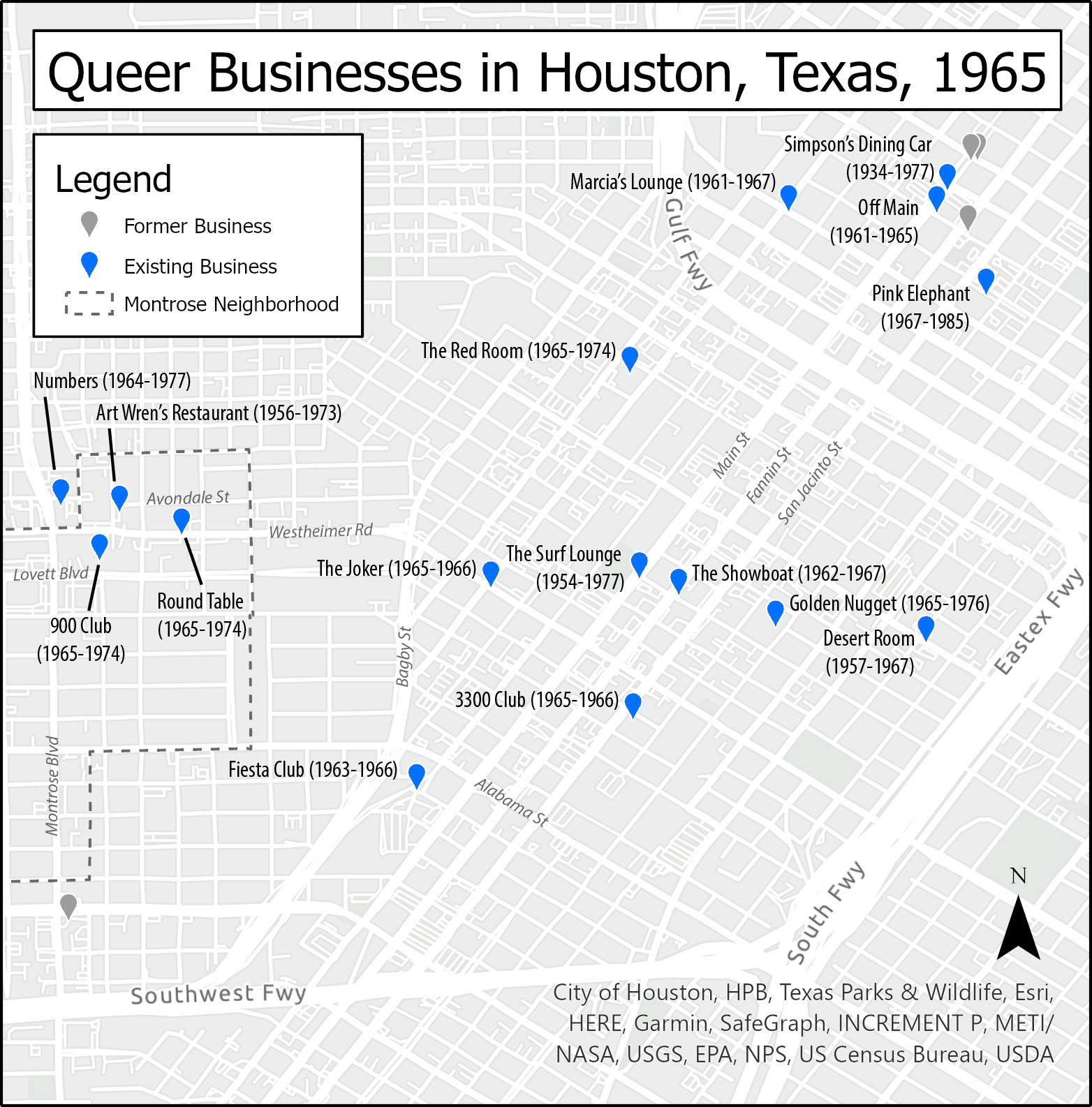
By 1965, three bars had also opened near the Avondale area: Numbers on California, the 900 Club on Lovett Boulevard, and the Round Table on Westheimer. Business owners and newspaper editors whose livelihoods depended on steady commerce likely also understood that the safety of their customers ("the good people of our community") was a prerequisite for their reliable patronage: all the more incentive for Bob Eddy—owner of Houston's Showboat and editor of The Albatross— to launch his paper with the "phantoms" as front-page news.
1970–1972: "Risky Crusing" and "The Heat"
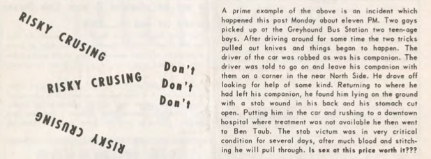
While The Albatross' article was circumspect or perhaps even purposefully vague, five years later The Nuntius33"The Nuntius & Our Community," Houston LGBT History, accessed October 1, 2020, http://www.houstonlgbthistory.org/nuntius.html. The Nuntius was published in Houston from 1970 to 1976. would explicitly center dangerous activities in the title of an article: "Risky Crusing, Don't" [sic].34"Risky Crusing, Don't," The Nuntius 1, no. 20 (August 1970): 12. http://www.houstonlgbthistory.org/Houston80s/Assorted%20Pubs/Nuntius/nuntius-1-2-8-70.pdf. Interestingly, the nonstandard spelling of cruising as "crusing" is consistent in this article; this essay honors that spelling as an historical artifact. The article references areas from Memorial Park to Midtown and the dangers such places offered would-be pleasure seekers. It cheekily opens with a reminder that cruising could "furnish you with a free ride downtown, cost you money, embarrassment and perhaps a great deal of time away from home." The "free ride" at stake here was likely to a police station, but perhaps also to a hospital. The article closes more seriously with the tale of one man who ended up at the Texas Medical Center's Ben Taub General Hospital35Ben Taub General Hospital opened in 1963 in the Texas Medical Center and is named after the Jewish businessman and philanthropist, Ben Taub (1889–1982) who never married. after being stabbed multiple times. It ends with the question: "Is sex at this price worth it?" Despite the core message to avoid danger, the article's geographical details simultaneously functioned as a guidebook. The description of Montrose even plotted a list of specific streets (see map below for an illustration of the "round-robin"):
The round-robin at Lovett Boulevard, Roseland, Hawthorne, Stratford, California, Avondale—well, you know the area better than I. This is not risky but just dangerous as h—. There have been many, many crusy [sic] queens beaten, stabbed, robbed and almost killed from picking up tricks in this area. This bad news area is a definite "No-No."
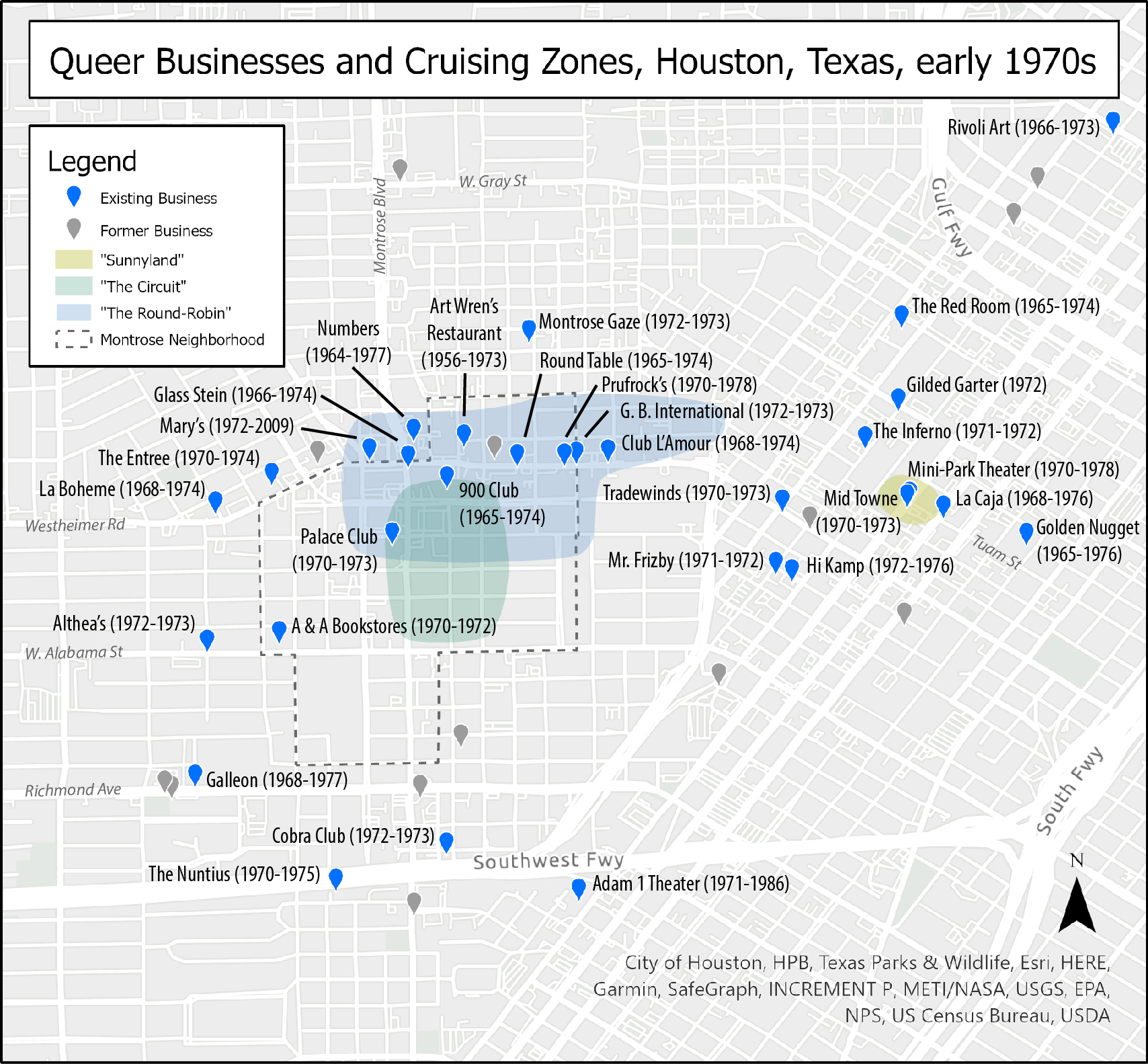
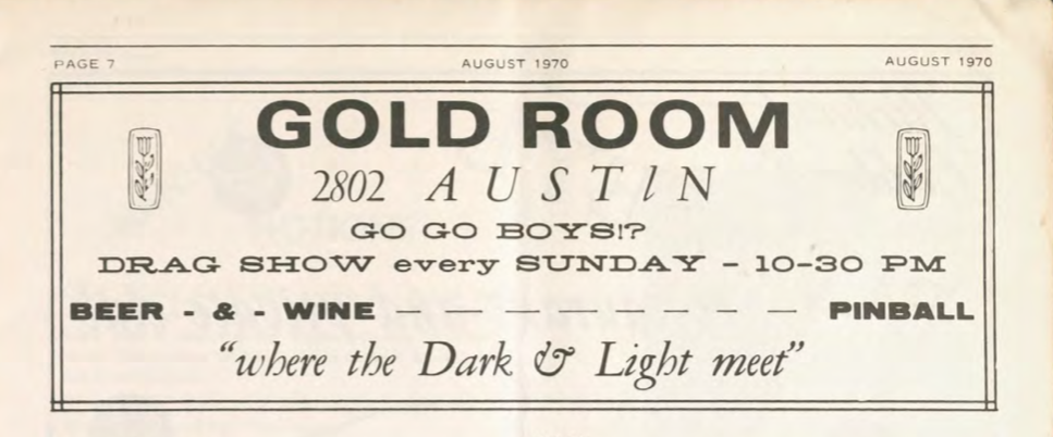
Midtown received an equal measure of detail, including specific landmarks like "Sunnyland Furniture" at Main and Tuam (also illustrated in the map above).36Suniland Furniture was located at 2817 Main Street. See a discussion thread on the Houston Architecture Information Forum, accessed December 31, 2019, http://www.houstonarchitecture.com/haif/topic/26168-suniland-furniture-building-2817-main-st/. But it is not as if these locations were entirely accidental. By 1970, the Montrose "round-robin" encircled a collection of eight queer establishments, with Art Wren's at the center. In Midtown, the intersection of Main and Tuam was also quite close to a number of other venues catering to queer community. The mapping project documented three queer businesses that operated in the 2900 block of Main—The Surf Lounge and two Nuntius advertisers, The Midtown Lounge and the Mini-Park Theater. A block away on Tuam was the successor to the Showboat, La Caja (also a Nuntius advertiser). A few blocks further was the Gold Room, a bar whose majority Black clientele likely inspired the tag line for its advertisement in the same issue of The Nuntius: "Where the Dark & Light Meet."37Gold Room advertisement, The Nuntius 1, no. 2 (August 1970): 7. Cruising was certainly one reason why some queer people went to these parts of town, but it was not the only reason. Moreover, the concentration of queer businesses and the visibility of queer people on the street did not guarantee safety for queer people in these areas, whether that danger came from police, thieves, or tricks gone wrong.38I am grateful to a peer reviewer who suggested comparing crime rates in known cruising areas against crime rates elsewhere in Houston; that work remains a compelling future area for research.
Not all welcomed cruising in public. In early 1972, The Nuntius ran a short article, "Heat on the Circuit," several pages in that describes how "the Houston Police have been making every effort to curb the crusing [sic] in the areas of Lovett, Roseland, and Marshall Streets" (labeled as "The Circuit" in the map above).39"Heat on the Circuit," The Nuntius 3, no. 1 (January 1972): 15, http://www.houstonlgbthistory.org/Houston80s/Assorted%20Pubs/Nuntius/nuntius-3-1-72-ocr.pdf. While the title and opening lines suggest the police (the "heat") should be the readers' main subject of concern, the article gestures toward the residents, "disturbed because of the heavy auto and pedestrian traffic during the late hours at night." The language to describe police efforts to "curb" cruising also suggests its readers might still have had an ambivalent relationship to the police. The article is also a form of soft control; it notified readers that officers were active in the cruising area and those cruising may wish to avoid encountering them. At the same time, the text describes the officers as "very cordial in the stopping and questioning of unauthorized persons frequenting this section." The police forces depicted here show at least a surface of courteous concern. Those with a legitimate (respectable) reason to frequent the area need not fear, but passers-through might still doubt who the final arbiters of that legitimacy would be. Presumably, the "unauthorized" could include both the cruising "hungry hannas" and criminals who prey on them, but we cannot assume that Montrose residents, their visitors, business owners, and bar customers themselves never cruised the streets where they lived, worked, and played. The Nuntius' depiction of the neighborhood shows several subtle but important shifts from the arrangement of queer community and police that marked the Albatross' item on the "'Phantoms' of Avondale." By 1972, queer pedestrians and drivers had become more visible, perhaps even emboldened in a post-Stonewall era, but were still at risk from both criminals and the police. Officers for their part had also become more vigilant. While queer people clearly remained subjects of potential police control, it appears that some were slightly more likely to see themselves as subjects of potential police protection, at least those queers who might be "authorized" to be walking or driving around Montrose as respectable residents, guests, or consumers.
These two articles from 1970 and 1972 also continue the trend of prior cruising narratives; neither mentions race in any explicit way. That absence of racial awareness reflects the dominance of white narratives in Houston's queer press at the time, but is also a curious elision given the rising visibility of Houston's Black queer life both locally and nationally. Beyond the Gold Room's advertisements in The Nuntius, the 1971 Damron Guide also coded the Gold Room as a very popular Black bar.40"Texas Bars, Baths, Etc.: From Bob Damron's Address Book 1971," Houston LGBT History, accessed October 1, 2020: 112, http://www.houstonlgbthistory.org/houston68-71.html. More curious still is that The Nuntius ran multiple stories in 1971 about the Houston Gay Liberation Front picketing the Red Room (see map above for location) because it did not admit Black patrons. Even as activists were calling attention to the segregation of queer spaces in Houston, these two narratives of cruising could omit explicit discussion of race in a multiracial city.
1971: "Come and Browse, or Vice Versa"
Evidence of cruising also appears beyond documents generated specifically by and for queer communities. For example, Mayor Louie Welch's records41Louie Welch Collection, MSS 51, Houston Metropolitan Research Center, Houston, Texas. To be clear about my archival process and research methodology, I did not know at first that Welch's papers held citizens' complaints and police records that would matter to documenting histories of cruising or of Montrose. I came across these records quite by accident while looking to substantiate historian James Sears' assertion that Welch and gay bar-owner George Hauger knew each other. I have yet to find any evidence to prove or disprove the assertion. See James Thomas Sears, Rebels, Rubyfruit, and Rhinestones: Queering Space in the Stonewall South, (New Brunswick, NJ: Rutgers University Press, 2001): 55. preserve a host of documents reflecting political and social currents that converged to regulate cruising. Of particular interest for this essay are citizens' complaints urging local authorities to shut down sexually-oriented businesses like video arcades that would "degenerate" their neighborhoods. That records of these complaints survive today, specifically in Mayor Welch's archive, attests to the power of the social and political forces converging on cruising at the time. Some citizens believed the authorities could and should address the issue, while for their part, the Mayor and other local authorities evidently deemed cruising important enough to track and combat.
Though locally produced, these citizen complaints also stand in complex relationships with national anti-pornography campaigns, religious organizations, and conservative political movements, as analysts like Whitney Strub have argued.42Whitney Strub, Perversion for Profit: The Politics of Pornography and the Rise of the New Right (New York: Columbia University Press, 2011). In the case of Houston, some complaints to the Mayor were clearly driven by national mailing campaigns from organizations like Charles Keating's long-running Citizens for Decent Literature (CDL). Sometimes, these campaigns arrived in the mailboxes of people already deeply engaged, for whom CDL mailings were both affirmations of and ammunition for their existing efforts. When these local complaints target businesses serving a queer clientele, national anti-pornography campaigns enter into a network of converging effects in which battles to define urban space result in the arrests of both consumers of queer pornography and patrons using those video arcades to cruise in semi-private and presumably safer, commercial spaces.
The Police Complaints and Criminal Intelligence Report folders in Welch's papers reveal a chain of communications among the public, the Mayor's Office, and Chief of Police Herman Short. Those communications in turn generated specific police activities directly affecting queer lives. These records show not only that Chief Short's police department was to varying degrees responsive to Houstonians' complaints of perverse activity in their city, but also that it proactively engaged in intelligence gathering to infiltrate and map the social networks they saw as driving both perversion and social instability. The Criminal Intelligence reports track investigations into presumed weapons dealing by Black militants and meetings of leftist groups like the Socialist Workers Party43The Socialist Workers Party is a communist organization in the United States that traces its roots to 1928. In Houston, Texas, the SWP acted in coalition with other organizations on the left, including the Gay Liberation Front. and the Mexican American Youth Organization.44The Mexican American Youth Organization formed in San Antonio, Texas in 1967, and was regarded as a militant form of Chicano activism, especially relative to mainstream organizations like League of United Latin American Citizens. In Houston, MAYO had strong ties to the University of Houston campus, much like the Gay Liberation Front Houston. They also track claims of reciprocal arson among rival gay bar owners, intimidation tactics among national pornography distributors vying for control of the Houston market, and individual members of Houston's nascent Gay Liberation Front.45The Gay Liberation Front formed in New York shortly after the Stonewall riots of 1969, and quickly spread to Canada and the United Kingdom. Though it would frequently collaborate with other left organizations, it was short lived; other lesbian and gay organizations had largely supplanted it by the mid-1970s. In Houston, a branch of GLF formed in the Montrose neighborhood in September 1970 and organized a student group at the University of Houston.
To offer one example in which citizens' complaints of cruising converged with local police priorities and national anti-pornography campaigns, consider the correspondence between the office of the Mayor and a Montrose resident named R. L. Martinson.46Reproducing Martinson's real name is a considered choice. Primarily, he made himself a subject of public record by sustained communication with public officials. Also, unlike the letter writers in Craig Loftin's compilation, his actions at the time would not be interpreted as criminal, regardless of how we today might ethically evaluate those actions. Martinson took several opportunities to urge the city to prevent what he saw as the decay of Montrose. In a letter dated October 29, 1971,47Correspondence from R. L. Martinson to Mayor Louie Welch, 29 October 1971, MSS 51, Box 30, Folder 2, Louie Welch Collection. Martinson reminded the Mayor of a letter from some months before in which he had asked for help "to rid this and other neighborhoods of the filthy atmosphere of the adult book store and lewd movies." While his complaint might at first be taken as a generic complaint about pornography, he then specifically mentions the return of an adult bookstore ("Story Book") at the former location of the "Adult Library and Mini-Theater" at 1323 West Alabama, an advertiser in The Nuntius (though at the slightly different address of 1312 West Alabama; see map above). The location for both operations was only one block from Martinson's residence, today just north of St. Thomas University and west of the Annunciation Orthodox Church.
In an all too familiar rhetorical move foreshadowing Anita Bryant's 1977 "Save Our Children" campaign, Martinson focused on protecting "youngsters" from the "crowd of homosexuals and perverts who roam the neighborhood night and day." Whether or not Martinson's "roaming" is the same distinctively spelled "crusing" that The Nuntius warned its readers against, the situation apparently had been sustained for some time, as Martinson writes that he and his neighbors "have suffered enough in the past two years." Indeed, queer newspaper advertising indicates that the Adult Library first opened on Alabama in 1970.48The Houston City Directory intriguingly shows that, immediately prior, the location was occupied by "Miss Adorable Wigs." As a 24-hour venue advertising with the tag line "Come and Browse, or 'Vice-Versa,'" the Adult Library would indeed have attracted the kind of cruising traffic Martinson's "roaming" describes. The "Vice-Versa" also underscores how unlikely it was that customers came to the store just to browse. Presumably, most would browse the movies and the clientele on offer in the relative privacy of the store's video arcade. Perhaps they would select one or more sex partners—especially if the viewing booth they chose offered openings into other booths. In all likelihood, given the purpose of such arcades and the business's tagline, many would also come before they left, whether or not this occurred with a partner.
Martinson's letters also demonstrate his willingness to argue that the laws supported his position and would empower city authorities to act accordingly, though his own narrative is vague about precisely which laws might actually have done so. His October 1971 letter refers simply to "a new law which apparently went into effect September 1." Martinson clearly assumed this law somehow led to the closure of the Adult Library. More specifically, in another letter to the Mayor dated February 12, 1972,49Correspondence from R. L. Martinson to Mayor Louie Welch, 12 February 1972, MSS 51, Box 30, Folder 4, Louie Welch Collection. he writes that "sodomy charges" were at stake. At the time, Texas and most other states did indeed have sodomy laws on their books; in 1972, the Texas statute also included heterosexual non-reproductive acts but would be refined in 1973 to apply only to same-sex acts. However, there was no 1971 adjustment to the Texas penal code and the various sex crime laws described in its Chapter 21. As Texas House Speaker Gus Mutscher lamented of the 62nd session: "The much-discussed penal code reform was the second failure in 'must' legislation for the session. The state bar-recommended revision as presented in HB 419, proved to be controversial enough that sponsors said they would delay action another two years."50Gus Mutscher, "Accomplishments of the 62nd Legislature," 1972, 9. Accessed June 24, 2020. https://lrl.texas.gov/scanned/SessionOverviews/62_Accomplishments_1.pdf.
Beyond Martinson's legal theories and emotions about the reopening of the adult business, his October 1971 letter is remarkable for the social imagination driving his proposed solution: "Let's put these dens of pervertion [sic] in an isolated part of town, if we must have them, and not allow them in residential areas or shopping centers to tempt our youth."51Martinson to Mayor Welch, 29 October 1971. Despite witnessing two years of night and day homosexual presence, Martinson apparently could not imagine even in late 1971 that his neighborhood might already be that part of town. Perhaps his concern was that it would soon become so in the absence of his complaints.
The official acknowledgement of his October letter was swift, even if action was not. The Mayor's office marked it to forward to Chief Short, and sent a brief note to Martinson dated November 3, 1971.52Correspondence from the Office of Mayor Louie Welch to R. L. Martinson, 3 November 1971, MSS 51, Box 30, Folder 2, Louie Welch Collection. Despite that note's assurance that Chief Short would investigate and be in touch in the near future, it appears Martinson did not receive any of the promised updates. In his letter of February 12, 1972, his tone shifts toward impatience as he writes "once more" to "inquire what, if anything is being done about places such as the 'so called' Story Book at 1323 West Alabama."53Martinson to Mayor Welch, 12 February 1972. The invective of this letter targets "perverts" as it marks the frequent traffic of "characters" that circulate without "merchandise" at Story Book and the nearby Grass Hut, a venue other complaints mark as a "pot-parlor."54Correspondence from Coralie Anderson to Mayor Louie Welch, 28 April 1971, MSS 51, Box 29, Folder 12, Louie Welch Collection.
This February letter also surfaces a powerful converging effect: Martinson specifically refers to the January–February 1972 National Decency Reporter, a newsletter from Citizens for Decent Literature. Per Martinson, it reports "crackdowns And Convictions in Ohio, Nebraska, California, among others."55Martinson to Mayor Welch, 12 February 1972. Capitals and underscore in the original. Martinson's February letter received a similarly swift acknowledgement from the Mayor's office, dated February 17, once again noting that the complaint had been forwarded to Chief Short, but this time without any promises of further communication.56Correspondence from the Office of Mayor Louie Welch to R. L. Martinson, 17 February 1972, MSS 51, Box 30, Folder 4, Louie Welch Collection.
Although Martinson may not initially have received the degree of response he sought, action was eventually forthcoming. An internal police memo dated March 21, 197257Internal police memo from Sergeant T. R. Driskell to Lieutenant J. M. Albright, 21 March 1972, MSS 51, Box 30, Folder 4, Louie Welch Collection. went from Sergeant T. R. Driskell of the Vice Division up the chain of command via Lieutenant J. M. Albright to Chief Short, and from him to the Mayor, per a March 22 memo from Chief Short.58Internal memo from Police Chief Herman Short to Mayor Louie Welch, 22 March 1972, MSS 51, Box 30, Folder 4, Louie Welch Collection. The details of Driskell's memo illustrate how Houston police officers enacted the laws available to them as they understood them, while the chain of communication itself shows how closely the Mayor personally monitored police actions regarding the gay community. Driskell reported on the status of the state sales license, which cleared their check. Eight mini-movie machines were noted in the rear of the bookstore. Police surveillance further "revealed" that "homosexuals frequent this place,"59Driskell to Albright, 21 March 1972. although it is unclear precisely what techniques of surveillance and evidence substantiated that claim. It is clear, however, that on March 8, 1972, five patrons were arrested and charged with committing an "Indecent Act" under the then-operative Chapter 21 of the Texas Penal Code. "The manager was not arrested" as "he was not involved."60For those who have ever visited adult bookstores with video arcades, this exclusion might not surprise: a manager is usually up at the front, selling access to the movie and cruising area at the back. That said, I am also grateful for a reminder from an anonymous peer reviewer that "owners of bath houses, bars, or cinemas sometimes faced police crackdowns in other cities, even if they didn't engage in sex themselves." The impact of these converging effects on the Story Book was much broader than this one raid, however. Driskell notes that since July 29, 1971, "there has been a total of 27 arrests for various offenses" at this location. He also reports "we are in the process of trying to get an injunction through Civil Court and have this place closed."
Perhaps unsurprisingly, none of Martinson's letters or the police memos explicitly mention race.
1974: "Rough Trade"
While Houston-based and locally-distributed publications like The Albatross and The Nuntius range from elliptical descriptions of cruising to explicit cautionary tales, Ralph W. Davis's richly photographed December 1974 article about Houston in the nationally-distributed gay travel magazine Ciao! verges on the celebratory.61Ralph W. Davis. "Houston," Ciao!: the World of Gay Travel. December 1974, 10–13; available also via the JD Doyle Archives: http://www.houstonlgbthistory.org/houston74.html. Ciao! was published out of New York City from 1973 through 1980. For more about the impact of Ciao!, see Lucas Hilderbrand, "A Suitcase Full of Vaseline, or Travels in the 1970s Gay World," Journal of the History of Sexuality 22, no. 3, (2013): 373–402. Indeed, "Cruise Areas" constitutes the first major subsection of his four-page article. He rehearses several areas mentioned in prior publications, beginning with the following bolded statement: "The main cruise area is Roseland to Hawthorn to Lovett to Stanford. Lovett and Stanford, and Lovett and Montrose are good corners to linger on at night." After directing readers first to a part of Montrose only five blocks from R. L. Martinson's home, Davis then helpfully notes, "Lovett and Stanford is a little darker than the latter, and some may prefer this for obvious reasons." Those "obvious reasons" would likely include the cover that darkness can provide for either a quick outdoor sex scene or an increased degree of camouflage and anonymity for the long term lingering sometimes required to pick up a trick worth taking elsewhere.
For Davis, not all cruising areas come equally recommended. He specifically evaluates them in terms of their "roughness," with all the gender and class markers animating the 1963 letter to ONE. The cruise area section of Davis' article continues the pattern of past cruising narratives and gives no guidance about the racial mix of men frequenting any specific area. However, the individual bar listings within the article do occasionally reference race and nationality. The clientele of the country/western Golden Spur "includes some tough Latins and blacks"; the Gold Room gets a nod toward the end of the article as "an old established black bar"; the Athens Grill and Bar on the Houston Ship Channel is recommended as "the place to go for Greek sailors who, when a little drunk, swing either way," a variation on the theme of rough trade. None of these three bars are close to any of the cruise areas Davis names, however.
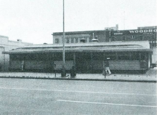
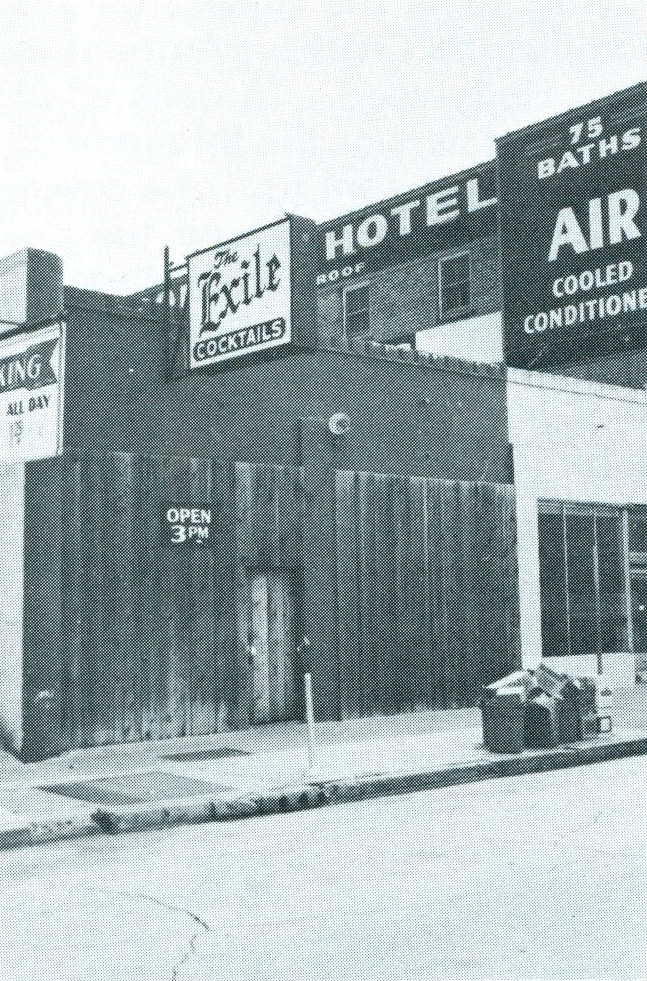
Of those cruise areas, Davis found the roughest one to be the Midtown corner of Bell and Main that hosts Simpson's Dining Car, the Exile Lounge, and, though he does not mention it in writing, the Woodrow Hotel. One hint toward the hotel's role comes when Davis notes "[o]nce Simpson's was a 24-hour restaurant; now it closes at 1 a.m. to avoid serving some of the hustlers and roughs who settle almost all night on the corner of Main and Bell." On the last page of the article, he also describes the Exile as "probably the most recommended of the rough bars."
To complete the implication, an examination of two accompanying photographs of Simpson's Dining Car and the Exile Lounge reveals the Woodrow Hotel looming in the background of both, boldly advertising "75 Rooms," "75 Baths" and "Air Conditioning" on the wall facing Main Street. Industrious Ciao! readers would also have seen that the Damron Guides for 1971 and 1972 also list the Woodrow Hotel.
For hustlers cruising for a living, that single block provided a ready-to-hand circuit of the necessities: food, drink, a steady stream of potential customers, and a private room and bath when it came to business. For out-of-town and local johns looking for the right place to go, Ciao! pointed the way. At Main and Bell, cruising and commerce commingled in a much more intense and intentional way than the Story Book on Alabama.
1976: No Turns
Although the 1972 Nuntius article gives the impression that residents played a minor role—at most complaining to the police who then in turn engage the "unauthorized"—residents do become more organized and vocal agents over time. In September 1975, Virginia Galloway reported in Update Texas that residents had formed the Montrose Citizens Association (MCA).62Virginia Galloway, "Montrose Circuit," Update Texas, Sept 26–Oct 3, 1975, 2. While the organization's name suggests an expansive membership, details on it are scarce; organizational records point only to the name of a lawyer in Montrose: Richard L. Petronella.63Initial research about the MCA surfaced a helpful clue for further work, although the source for that clue is suspicious. See "Montrose Citizens Association Inc." Bizapedia, accessed December 31, 2019, http://www.bizapedia.com/tx/MONTROSE-CITIZENS-ASSOCIATION-INC.html. That website provided the following data: "Montrose Citizens Association Inc. is a Texas Corporation filed on September 2, 1975. The company's filing status is listed as Franchise Tax Involuntarily Ended and its File Number is 0036646201. The Registered Agent on file for this company is Richard L Petronella and is located at 815 Hawthorne, Houston, TX . The company's principal address is 815 Hawthorne St Richard Petronella, Houston, TX 77006-3901." The Association's remarkable strategy eerily echoed R. L. Martinson's proposal to Mayor Welch: relocate the Circuit. Galloway reported that "area gay organizations" collaborated with the MCA to pass out flyers at street corners in the Montrose Circuit on Friday and Saturday nights, informing potential cruisers of the "moving of the historic cruising area" from Montrose to a "non-residential, semi-isolated area nearer downtown" that would supposedly be "more conducive to cruising conditions, since the roads are better and there is good lighting." The flyer included a map of the new location and described the reasons for the move: "an effort to cooperate with neighborhood residents, who are finding the activity on the Circuit increasingly more difficult to live with because of the noise and traffic in the early morning hours." Supposedly, an impending police crackdown could be avoided if the cruisers were to voluntarily relocate. Galloway's reporting gestured quietly to the odd optimism of the scheme: "most were eager to hear of the new area, although actual response by moving is still slight." Houston cruisers in 1975 might have also remembered Ralph Davis' Ciao! article recommending a specific intersection in Montrose as darker than others. "Good lighting" was a curious way to pitch a new cruising ground to that market.
Such tactics aside, MCA's flyer campaign clearly required significant planning and volunteer effort, from designing and printing the flyers to the volunteer time of handing them out at multiple intersections on multiple nights. Although attorney Petronella is the sole name listed on the organization record, clearly he was not acting as a lone agent. Other community organizations were involved, perhaps even the Houston Police Department, especially if the new location for the Circuit would not also be subject to a police crackdown. Presumably, MCA also checked with the residents and business owners in the proposed new location to be sure cruising would not present a problem to them as well.
However, the Montrose Circuit's decade-long reputation as a cruising ground proved harder to break than the MCA campaign at first envisioned. Just a few months later, in March 1976, Mel Plummer (former owner of Update Texas) wrote a column for The Nuntius titled "Houston Cruise Circuit Closed," in which he argues that the flyer campaign failed because the roads at the new location could not handle the volume of car traffic, particularly during the peak weekend hours for the nearby Farmhouse, a three-story gay bar on Albany.64Mel Plummer, "Houston Cruise Circuit Closed," The Nuntius (March 1976): 3. http://www.houstonlgbthistory.org/Houston80s/Assorted%20Pubs/Nuntius2/Nuntius%20SW-031276.pdf. This article repeats and extends a story of the same name run in the previous February issue. See The Nuntius (February 1976): 2. http://www.houstonlgbthistory.org/Houston80s/Assorted%20Pubs/Nuntius2/Nuntius%20SW-020676.pdf. He places responsibility for this failing on MCA for choosing the relocation area on its own, rather than consulting first with "those involved with the Montrose circuit." Plummer's reporting also answered a curious gap in Galloway's account: he specified the gay organizations working with MCA as the Gay Political Caucus, the Metropolitan Community Church, and "other local organizations"—some of whom could also have offered expert guidance on the move. With the failure of the flyer campaign, Plummer reports that MCA escalated its efforts and barricaded the roads one night, purportedly with collaboration from the office of Mayor Fred Hofheinz. Plummer also casts doubt on that last claim, noting that the City had issued no permits and the police did not supervise the barricades. The barricades were not MCA's final option, however. The Association apparently described this new tactic as "their last stand before police harassment would begin to all those who frequented the infamous 'Montrose Circuit.'"65Ibid. The cordiality evoked in the 1972 The Nuntius article had evaporated.
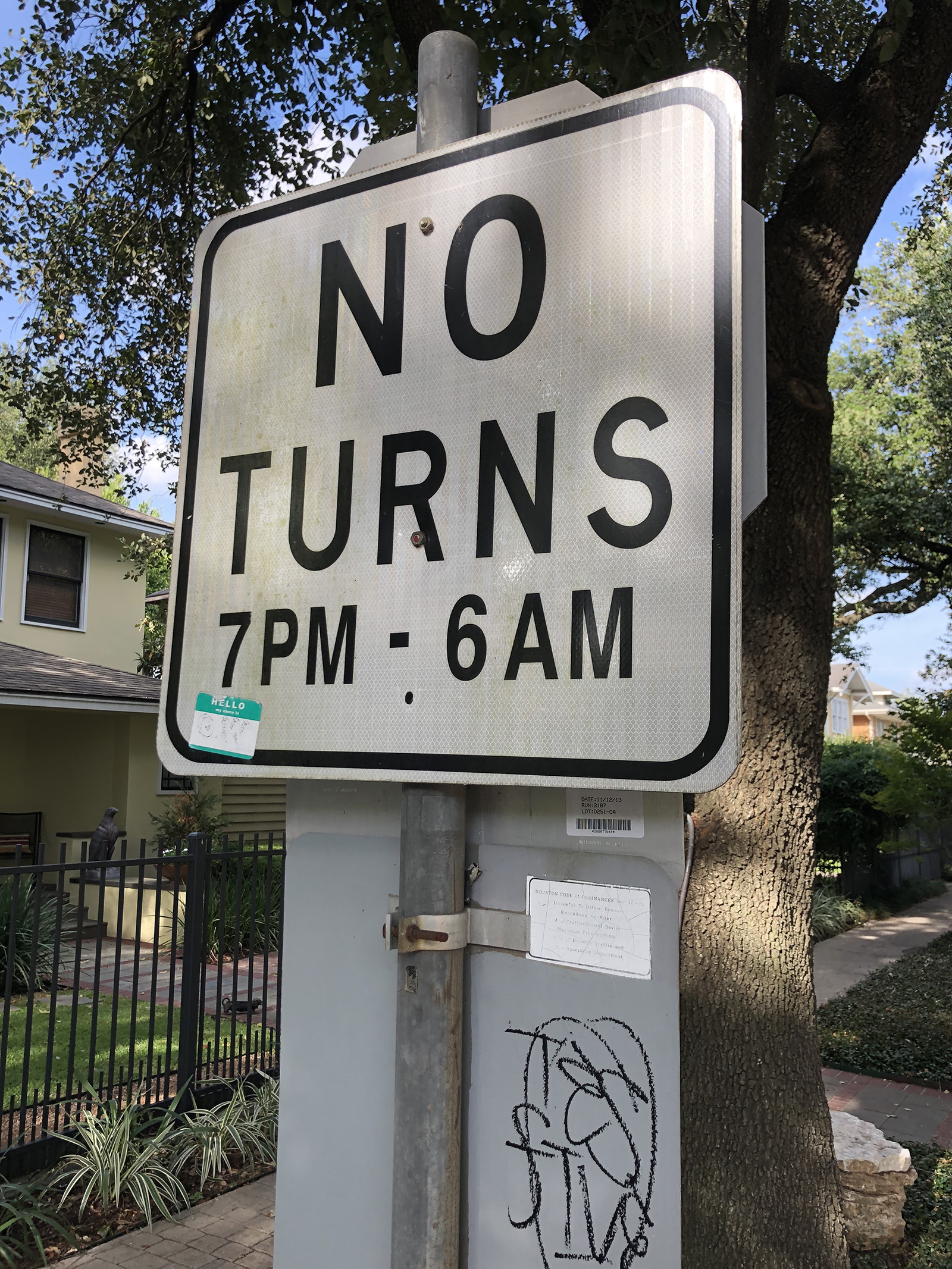
MCA unleashed that final option on Wednesday, January 28, 1976.66Plummer's article reads "January 26," an apparent editing error. With the evident cooperation of the City of Houston, MCA installed signs prohibiting vehicles from making turns between 7 p.m. and 6 a.m. in the Montrose area. These no-turn signs restricted those cruising by car from circling legally through the side streets of the neighborhood, breaking the social pattern connecting cruisers on foot with cruisers in cars. Indeed, Plummer reports that the next night "Houston Police issued 43 traffic citations for illegal turns and five people were taken to jail. This has all but assured that the Montrose Circuit exists no more."67Ibid. Importantly, this "death" of the circuit also became mainstream news; Houston television stations picked up the story with what Plummer describes as "fair and unbiased reporting." To be sure, the crackdown on cruising in Montrose did not spell the death of cruising itself. Even as Plummer asserts that "most Gays have not found a new cruise route," he goes on to observe that "many are returning to the old cruise route before the days of Montrose. This was known to many as Suniland. The area consists of the streets Main, Tuam, Fannin, and Anita."68Ibid. Indeed, these are the very same streets The Nuntius readers might remember as too risky, as places where pleasure mingles with danger. One implication of this strange return is that the shifting of neighborhoods and cruising areas is not uniform, unidirectional, or irreversible.
It is also important for us today to recall that queer folk were not always victims but also sometimes the perpetrators of surveillance and violent crime in 1970s Houston. Such crimes may also have influenced those seeking to shut down or relocate cruising areas. Many of these crimes are all but forgotten. For example, The Nuntius ran a 1971 story about a teenage boy who was picked up by two men in downtown Houston and taken back to their residence in Montrose, "known to the most of us as 'the colony.'"69"Halloween Horror for 16 Year Old Boy," The Nuntius 2, no. 11 (November 1971): 1. http://www.houstonlgbthistory.org/Houston80s/Assorted%20Pubs/Nuntius/nuntius-2-6-11-71.pdf. After what initially seemed to be an evening of drinks and movies, the boy "stated that he was knocked in the head by one of the men and tied up, beaten with a rubber hose and sexually assaulted by the pair."
Other crimes catapulted into the national consciousness. As Montrose residents and cruising men were engaged in their turf wars, Dean Arnold Corll had already begun what would come to be known as the Houston Mass Murders or the Candy Man Murders, in a gruesome nod to Corll's family business. Between 1970 and 1973, he and his accomplices are believed to have abducted, sexually tortured, and killed at least 28 teenage boys. While most of these boys had deep connections to or were taken in the Houston Heights area, the symbolic impact of the murders extended to all of queer Houston when the case was finally exposed in 1973 after one of Corll's accomplices murdered him. At the time, it was the worst serial murder case in United States history. The denouement of the Candy Man Murders played out the same year the American Psychological Association removed its classification of homosexuality as a mental illness in the Diagnostic and Statistical Manual.
More intriguingly still, even as the Montrose Citizens' Association began its 1975 flyer campaign, the Houston Chronicle began reporting on a string of murders in Montrose, mostly of men, many of them graphically violent. Then the Chronicle's January 8, 1976 front page ran the headline "Homosexual Tells Police He Killed 3 Men Here." The first line of that story described the confessor, Joseph Standwick, as "an admitted homosexual."70"Homosexual Tells Police He Killed 3 Men Here" Houston Chronicle, January 8, 1976, Sec. 1, 1. Later coverage would add to that description: "admitted homosexual and male prostitute."71"Homosexual Suspect in 3 Slayings Questioned by Arson Investigators," Houston Chronicle, January 9, 1976, Sec. 1, 12. Such headlines and biased language deepen our understanding of why Plummer might specifically comment on the "fair and unbiased reporting" regarding the no-turn signs and cruising; just weeks before the no-turn signs went up, many Houstonians were imagining a murderous, gay prostitute in Montrose.
In that context, battles over whether gay men could or should claim Montrose as their cruising grounds have an understandable urgency, and not just for cruising men concerned about their own safety. As Ralph Davis wrote in Ciao! in 1974, "[t]he Mayor, in order to reduce growing tension arising between straights and gays, immediately advised bar owners that he would not interfere with business so long as their patrons weren't a public nuisance."72Davis, "Houston," 10. Given prior police raids on the Story Book and any number of other queer establishments, cruising men might mistrust such promises. Cruising in Montrose was steeped in emotions and conflicting interests: straight-gay tensions, business concerns, residents' long-standing noise and traffic complaints, and murderous headlines (none of which ever mentioned race as a motivating factor). To be clear: no extant records indicate that the Montrose Citizens Association explicitly or implicitly connected the Candy Man and Joseph Standwick to men cruising Montrose for sex. Still, the possibility of that connection may help explain how the MCA came to have the support of the Gay Political Caucus and the Metropolitan Community Church, both organizations invested in promoting the respectability of gay people.
Time would prove the MCA's no-turn signs to be a limited success, however. A decade later, a new no-turn sign campaign launched in Montrose, and the occasion spurred many to recall the limitations of the 1976 MCA effort. Connie Woods described the new campaign in the Montrose Voice: "signs went up . . . at four intersections between Alabama and Harold at the request of the Montrose Ltd. Homeowners Association, creating controversy among residents of the neighborhood who were unaware of such requests."73Connie Woods, "New 'No Turns' Street Signs Go Up," Montrose Voice, January 24, 1986, 11. She closed the article with a brief, neutral nod to the past: "Such traffic signs were first established in the Lovett Blvd. and Stanford area on the south side of Westheimer in the 1970s to discourage 'cruising.'" The pages of This Week in Texas (TWT) offered stronger commentary, quoting Montrose resident Charlie Miller: "Responsible people will note that these signs didn't stop cruising when they were erected on the east side of Montrose Blvd. . . . The circuit merely moved, and most likely will relocate again."74"Cruise Area Under Attack," This Week in Texas 11, no. 46. (January 31–Feb 6, 1986): 19–20. http://www.houstonlgbthistory.org/Houston80s/TWT/1986/86-013186.compressed.pdf. TWT also quoted a 1985 letter from the Montrose Ltd. Homeowners Association to the city's Traffic and Engineering Department which made it clear they aimed to limit cruising:
The traffic begins increasing at dusk, is heaviest between 10 p.m. and 3 a.m. and continues until approximately dawn [… ] Most of the vehicles circle 10 or more times, but some have circled 50 or more times in one night. Depending on the day of the week, there are between 10 and 40 cars circling the block […] It's not unusual for four or more cars to be queued at each stop sign, waiting to turn the corner.
TWT readers were eager to share their thoughts in return. Bill Jackson wrote: "My apartment manager is, I believe, president of the homeowners association. I know, based on a conversation with him last fall, that they think anyone walking in the evening is soliciting, if not selling it."75Bill Jackson, "Letter to the Editor," This Week In Texas 11, no. 48 (February 14–20, 1986): 21. http://www.houstonlgbthistory.org/Houston80s/TWT/1986/86-021496.compressed.pdf. For his part, Don Buch argued that no-turn signs "demean and cheapen our Montrose properties and do not address the 'cruising' problem. It is in fact just a political tool for Houston police."76Don Buch, "Letter to the Editor," This Week In Texas 11, no. 48 (February 14–20, 1986): 23. As of this writing, some of the no-turn signs remain: two at the intersection of Marshall and Graustark, and nine along Roseland and Stanford streets. Despite consistent efforts from a variety of forces, the Montrose cruising circuits remained resilient.
Cruising Toward Theory
Taken together, these seven narratives of cruising do not describe an uncontested process of place claiming and recognition as Levine's model implies. Instead, they show territorialization through cruising to be temporally bound, conflicted, and structured in part through a politics of respectability explicitly linked to class concerns but uniformly silent on race. Considered alongside the brick-and-mortar locations of commerce and consumption that informed my earlier ArcGIS animation, these cruising narratives show that queer territories often operate on very different scales within and across multiple spaces. In these stories, the most typical scales of urban territory described are specific street corners, a few adjacent blocks, or occasional larger areas. Sometimes, but not always, these cruising grounds are connected to the commercial spaces privileged in the animation.
As the narratives attest, the practice of cruising has proponents and detractors. Tension over this practice in Houston largely stemmed from the range of agents involved and the variety of positions these agents took up on cruising. Over the years of analysis, the queer press promoted a number of stances on the behavior: discretely framed warnings, explicit admonitions that conveniently double as instruction manuals, and almost celebratory accounts of where specific kinds of action are to be found, ranked by dangers not limited to the threat of an encounter with the police. Queer and non-queer agents also intervened in a coalition to curb cruising. The Montrose Citizens Association had some degree of cooperation from the Gay Political Caucus and the Metropolitan Community Church. That alliance of respectable, community-oriented organizations built on years of residential complaints of noise and traffic even as Houstonians learned about a murderous gay prostitute in Montrose. The City of Houston directly engaged through policing, constituent messaging, and posting signage. Resilient sex-seekers responding to all of these agents seem to have found other places to pursue the chase, in part through cruising grounds remembered from other times. They had many alternatives available in collective, living memory, from cruising spots in downtown, Midtown, Montrose, Memorial Park, the Galleria, and beyond, to the adult bookstores and video arcades across the Houston landscape. At the same time, sex-seekers persisted in cruising areas like the Montrose Circuit, despite continuous efforts to displace them.
Beyond literal embodiments and emplacements, these narratives also illustrate that queer territories become so because both those who do identify as queer and those who do not identify as queer imagine them to be so. The full cast of characters holding these mental maps ranges widely in power, from unnamed neighborhood residents to the Mayor of Houston. These actors can be close to the field, like Richard L. Petronella and R. L. Martinson, and quite distant, like those reading Ralph Davis' article in the nationally circulated Ciao! magazine.77Benedict Anderson's arguments are particularly relevant here. See his Imagined Communities: Reflections on the Origin and Spread of Nationalism (New York: Verso Books, 2006). Patterns of rough trade visible since the 1960s also suggest that some men—at least those who cruise other men for sex and do not identify as queer—also carry mental maps of queer territory, if only to avoid those places lest the label stick to them.
As such, these seven cruising narratives present queer territory in Houston as a fractured and shifting network of sites imagined and contested by multiple populations, some of whom also participate in those scenes. Such an arrangement of queer territory strongly supports Ghaziani's concept of "cultural archipelagos" more than any model of a single, "gayborhood" enclave. Moreover, Gieseking's mental maps offer a well-attuned method to document the multiple social networks imagining those multiple cruising areas, at least for those living today. For the departed, the method of archival research present in works like this one will have to suffice.
These historical cruising narratives also pose several questions for future work, particularly as we explore the practice of cruising as it intersects race. Contemporary narratives like Espinoza's describe cruising as a ground on which men may meet other men of many different bodies, races, and classes. His is not a uniformly utopic stance, to be sure. He writes of people rejected for the color of their skin or the shape of their body while cruising. He acknowledges that many progressive projects, queer theory in particular, are rightly critiqued for "shutting out the lived realities of Black, Asian, Brown, and disabled queers altogether."78Espinoza, Cruising, 204. On the whole, this book leans more toward the utopia of cruising than its critique. And yet, immediately after that acknowledgement, his text embraces utopic potential: "The cruising ground erases these divisions, allowing for a more egalitarian experience not predicated on racial constructions" (Ibid., 204).
So what should we make of a body of Houston cruising narratives in which the division of race is indeed erased, so much so as to render race essentially invisible rather than seen? Perhaps it should not surprise that race goes so consistently unmarked in cruising narratives taken from Houston's white-dominated queer press. The pattern also extends nationally: as the Damron Guides began to mark race and to list cruising areas in the early 1970s, Houston's bars (the brick and mortar) were often coded for race; the archipelagic cruising areas were not. Perhaps the presumption was that, because cruising areas ranged from public outdoor space to semi-private commercial settings and were therefore "open to all," there was no reason to mention, much less mark, race. Here, oral histories with cruisers themselves would offer invaluable evidence about actual practices on the ground.79Literary accounts are also helpful, like Samuel Delaney's in Times Square Red, Times Square Blue (New York: NYU Press, 1999) or The Motion of Light in Water: Sex and Science Fiction Writing in the East Village (Minneapolis: Minnesota University Press, 2004). He was not writing of Houston however. Edmund White's States of Desire: Travels in Gay America (Madison: University of Wisconsin Press, 2014) moves through much of the South, including Houston. At the same time, that silence marked not just queer narratives. Race was similarly absent in the cruising narratives from concerned citizens and police reports. In these narratives, race's systematic absence certainly suggests the primary "problem" was the transgression of respectability in residential neighborhoods, for which the race of the transgressors could be framed as irrelevant. That race is unmarked in all the cruising narratives suggests that a broader logic may have operated, what Peggy Pascoe termed a "modernist racial ideology" that took "color blindness"—not seeing color—as a virtue.80Peggy Pascoe, "Miscegenation Law, Court Cases, and Ideologies of 'Race' in Twentieth-Century America," The Journal of American History 83, no. 1 (June 1996): 48. That ideology links drawing attention to race with racism itself. Even as it disavows racism, then, that ideology rationalizes silence about race, and also allows white privilege and white supremacy to continue, unnamed and unexamined, even in landscapes of contested respectability like cruising grounds.
At the same time, race was very much "on the map" of the queer press in Houston. As early as 1968, The Albatross marked the Gold Room as catering to Black queer Houstonians. The Nuntius covered the Gay Liberation Front picket of the Red Room for not admitting Black patrons (and disparaged the GLF in the process). Ciao! reported that "Latins and blacks" could be found at the Golden Spur. Upfront ran a substantial story on The Houston Committee, a Black social and political club that operated from 1975 into the 1980s.81For more on The Houston Committee, see "Houston Committee," Upfront 1, no. 2 (April 28, 1978): 2. http://www.houstonlgbthistory.org/Houston80s/Upfront/Upfront-V1-1-2.compressed.pdf. These descriptions fuel "mental maps" of a queer, multiracial Houston. However, these narratives of race functioned much as narratives of cruising did: they simultaneously allowed queer Houstonians to seek out racial diversity in some spaces while avoiding it in others.
In a final note toward future work, it is not as though queer territories emerge through cruising in just any location where enough people gather. These seven narratives show that other factors matter, such as relatively immediate access to semi-private spaces like wooded areas in a park (Memorial Park), bathrooms in a shopping mall (The Galleria), or a nearby and affordable hotel (The Woodrow Hotel). That benefit of access to semi-private space also undergirds the complex and varied relationships cruising areas have with specifically commercial space, and with cruisers' socioeconomic status and access to capital more generally. As the downtown window-shopping scene of the 1930s demonstrates, those commercial spaces need not be specifically queer, but must at least enable moments for discrete (respectable) communication, perhaps at a post while combing one's hair. As historian John D'Emilio might put it, such urban commercial centers help create the "conditions of possibility" for individuals to organize their lives, even if only in the ephemeral practice of cruising, through their sexuality.82See John D'Emilio, "Capitalism and Gay Identity," in The Lesbian and Gay Studies Reader, eds. Henry Abelove, et al. (New York: Routledge, 1993): 467–476. Proximity to specifically queer-centered businesses also enabled many cruising areas, albeit in flexible ways. The policed street scene outside a new bar described by the 1963 writer to ONE is quite different from the scene R. L. Martinson complained of almost a decade later—"characters" circulating in commercial space "without merchandise"—but perhaps Martinson was looking for a different kind of goods. While both narrators remark on the increased pedestrian and street traffic, Story Book created a commercialized space for cruising (and its consummation) to occur out of direct public view at the same time as both police forces and local queer press sought to control public street cruising. Said differently, the "good" that Story Book commodified was the affordance of relative privacy. While one could pick up a trick while walking outside a bar and never directly pay for that privilege, Story Book extracts payment for access to fellow sex-seekers in a semi-public and therefore marginally safer place, perhaps even with better odds of finding an available or desirable partner. The cruising scene on the corner of Main and Bell as described in Ciao! offers a different arrangement still, where some but not all of the cruising is predicated on sexual partners exchanging money directly. Also profiting from that scene are the three businesses—a restaurant, a bar, and a hotel—though at least the restaurant operators were ambivalent enough about that source of income to change their hours of operation to avoid the roughest of the rough. As a final thought, these varied relations to commercial space and capital suggest that histories of cruising not only deepen our understanding of how queer territorialization comes to be through archipelagic processes, but they also offer fertile ground for exploring the liberating potentials and structuring limitations of sexuality under capitalism.
Acknowledgments
This essay was specifically inspired by Amy Stone's call to study the South.83Amy L. Stone, "The Geography of Research on LGBTQ Life: Why sociologists should study the South, rural queers, and ordinary cities," Sociology Compass 12, no. 11 (2018). https://doi.org/10.1111/soc4.12638. Also, while this essay concentrates on men's cruising in Houston, anyone might look for sex partners in public. As Samuel Delaney argues in Times Square Red, Times Square Blue, public spaces that encourage social mixing (sexually primed or not) across class and race lines yield a civic texture worth preserving. Yet in both popular and academic analyses of public sexual behavior, the practice of cruising remains predominantly linked to gay men.84For example, see William Leap, ed. Public Sex/Gay Space (New York: Columbia University Press, 1999). An analysis of queer urban space argued from cruising alone would reproduce that limiting linkage, and yield a proportionately myopic mapping. Also, an analysis of queer rural spaces would require a different set of analytics still, one more attuned to mapping social networks of queer rural denizens (see John Howard's work for example) than mapping brick and mortar locations.85See Gray, Mary L., Colin R. Johnson, and Brian J. Gilley, eds. Queering the Countryside: New frontiers in Rural Queer Studies (New York: NYU Press, 2016).
In a note of gratitude, more people than I can name here contributed in meaningful ways to this essay. I am thankful for my writing group; Melissa Bailar, Anne Chao, and Robert Werth saw this work in its very first stages. I am indebted to the Rice University Feminist Research Group and Christina Hanhardt for formative feedback on what turned out to be the bones of this essay. I am also grateful to JD Doyle, Martin Sunday, and the editors and anonymous peer reviewers of Southern Spaces for their insights and commentary. All errors and omissions remain my own responsibility.
Many thanks as well to Southern Spaces staff member Stephanie Bryan, who helped create the digital maps published here.
About the Author
Brian Riedel is the associate director of the Center for the Study of Women, Gender, and Sexuality at Rice University, where he received his Ph.D. in Anthropology. His work has been published in the Journal of Mediterranean Studies, PoLAR: Political and Legal Anthropology Review, Somatechnics, CITE: the Architecture and Design Review of Houston, and in the anthologies AIDS, Culture, and Gay Men (University of Florida Press, 2010) and Homophobias: Lust and Loathing Across Time and Space (Duke University Press, 2009).
]]>Essay
In a 2017 essay, National Museum of African American History and Culture director Lonnie Bunch noted that, like much of black history, environmental activism by people of color is often "forgotten" or "hidden in plain sight." Bunch, now director of the Smithsonian Institution, labeled this movement work unacknowledged environmentalism. Environmental reform campaigns led by people of color and other marginalized groups include not only land struggles by formerly enslaved people and by Native Americans, but also agricultural movements and the class-based mobilizations of populist agrarians. Chicano farmworker fights against poisonous pesticides are environmental battles, as are African American civil rights campaigns for equal access to recreational areas and to safe spaces in cities.1Lonnie G. Bunch III, "Black and Green: The Forgotten Commitment to Sustainability," in Living in the Anthropocene: The Earth in the Age of Humans, eds. W. John Kress and Jeffrey K. Stine (Washington, DC: Smithsonian Books, in association with Smithsonian Institution Scholarly Press, 2017), 83–86, 86.
Recovering this history acknowledges that people of color and the poor have shared the passion for wilderness and the natural world that motivates preservationists. In the early twentieth century, for example, African American women and men hiked Niagara Falls and cycled in Yellowstone. George Washington Carver, as we know from historian Mark Hersey's 2011 study, explicitly cast his research and practice of agroecology in terms of conservation.2Mark D. Hersey, My Work Is That of Conservation: An Environmental Biography of George Washington Carver (Athens: University of Georgia Press, 2011).
However, the benefits of environmental citizenship are not and have not been distributed equally. People of color have fought to participate in the enjoyment of nature and the benefits to health those activities offered. "[T]he color line in any guise was inherently environmental," explains historian Mark Fiege. The spatial configuration of cities and towns, reservation boundaries, Jim Crow segregation on either side of the Mason-Dixon line, the contemporary policing of racialized spaces—all can be understood not only as battle lines in freedom struggles but also as unacknowledged elements of urban ecology, a denial of mobility, a constraint on access to space. "The criminalization of urban space," as scholar Yohuru Williams explains, increasingly has been recognized as a question of environmental justice.3Mark Fiege, The Republic of Nature: An Environmental History of the United States (Seattle: University of Washington Press, 2012), 320; Robert S. Emmett, Cultivating Environmental Justice: A Literary History of U.S. Garden Writing (Amherst: University of Massachusetts Press, 2016), 5; Yohuru R. Williams, Rethinking the Black Freedom Movement (New York: Routledge, Taylor & Francis Group, 2016), 115.
The environmental justice paradigm that emerged in the 1980s expands our understanding of what issues and concerns count as environmentalism. Native American groups lobby to redress exploitation of uranium miners. Organizations such as the Black Panthers and the Student Nonviolent Coordinating Committee (SNCC) identified environmental concerns not on the agenda of mainstream groups such as the need for rat eradication and demand for "community control" in urban areas. In their call for self-determination, black nationalists took up the slogan, "Free the Land."4Alondra Nelson, "The Longue Durée of Black Lives Matter," American Journal of Public Health 106, no. 10 (2016): 1734–1737, https://ajph.aphapublications.org/doi/10.2105/AJPH.2016.303422; Russell Rickford, "'We Can't Grow Food on All This Concrete': The Land Question, Agrarianism, and Black Nationalist Thought in the Late 1960s and 1970s," Journal of American History 103, no. 4 (March 2017): 956–980, 957.
Social justice environmentalists have sought not just the inclusion of people of color in the history and practice of conservationism, but a fundamental reorientation of the American environmental movement's concerns and aims. Calling for equal treatment of communities of color and for full participation by marginalized social groups in environmental decision-making, environmental justice proponents emphasize questions of power and rights. Scholars have often described campaigns so rooted in broader social justice movements that they were not recognized as environmentalism. Excluded groups link their appreciation of nature and desire for healthy surroundings to a broader vision of social justice inseparable from full social and political rights.
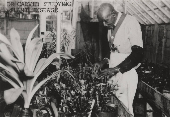
Stimulated in part by this reorientation, new histories of environmentalism and, to a certain extent, the movement itself have begun confronting the more complex and difficult elements of the conservation movement's past. From its beginnings, conservationism echoed the nation's conflicts over race and inequality. Several prominent early conservationists were also eugenicists. White supremacy and nativism—hostility toward immigrants—were integral to the way many early conservationists understood their work. These ideas infused (and continue to infuse) debates about overpopulation, immigration, and resource policy.5Robert Gottlieb, Forcing the Spring: The Transformation of the American Environmental Movement, rev. ed. (Washington, DC: Island Press, 2005), 24; Jennifer Clapp and Peter Dauvergne, Paths to a Green World: The Political Economy of the Global Environment, 2nd ed. (Cambridge, MA: MIT Press, 2011), 246; Ben Zuckerman, "Nothing Racist About It," Globe and Mail, January 28, 2004, theglobeandmail.com/opinion/nothing-racist-about-it/article741382/.
The early campaigns for wilderness preservation are now understood not only as preserving public lands and limiting habitat destruction but also as a race-making project, defining who could enjoy the full rights of citizenship. As historian Carolyn Finney and others have argued, the designation of national parks and wilderness areas often created "white spaces" by displacing native populations and excluding racial minorities.6Carolyn Finney, Black Faces, White Spaces: Reimagining the Relationship of African Americans to the Great Outdoors (Chapel Hill: The University of North Carolina Press, 2014); Miles A. Powell, Vanishing America: Species Extinction, Racial Peril, and the Origins of Conservation (Cambridge, MA: Harvard University Press, 2016); Alexandra Minna Stern, Eugenic Nation: Faults and Frontiers of Better Breeding in Modern America, 2nd ed. (Oakland: University of California Press, 2016). Nevertheless, a strong, identifiable thread of social justice thought and action runs through US movements for environmental reform. Individuals involved in environmental causes have often participated in actions to oppose racial injustice, eliminate poverty, and achieve gender equality. Such alliances have been essential to the success of the environmental movement.
Struggles over segregated space that highlighted injustices offer some of the clearest examples of unacknowledged environmentalism. When the Montgomery Improvement Association (MIA) campaigned to desegregate the bus system and open jobs to black citizens in Alabama's capital city, five of the organization's eight primary demands presaged environmental justice themes. Laid out in a flyer entitled "Negroes' Most Urgent Needs," the MIA's concerns included "Negro Representation on the Parks and Recreation Board," "Sub-division for housing," "Congested areas, with inadequate or no fireplugs," "Lack of sewage disposals makes it necessary to resort to out-door privies, which is a health hazard," and, "Narrow streets, lack of curbing, unpaved streets in some sections."7"Negroes' Most Urgent Needs," Inez Jessie Baskin Papers, Alabama Department of Archives and History, Montgomery, Alabama, as displayed at the Birmingham Civil Rights Institute, http://digital.archives.alabama.gov/cdm/ref/collection/voices/id/2019. All are urban matters that would today be regarded as environmental concerns.
African American activists were often first to join forces with other people of color facing environmental threats. For example, in 1966, comedian and civil rights activist Dick Gregory was jailed in Washington state for participating in a "fish-in" held by the Nisqually Indians and other tribes to protest restrictions on native fishing rights. Inspired by civil rights sit-ins and organized by the Survival of the American Indian Society, these protests at Frank's Landing in Puget Sound sought to prevent overfishing by commercial fisheries and to restore native treaty rights to fish in the region's bays and streams. At issue were the tribes' ecological heritage and livelihoods, as well as treaty rights and tribal sovereignty. Dr. King telegraphed his support. The Southern Christian Leadership Conference (SCLC) endorsed the effort; the NAACP Legal Defense Fund and the ACLU provided legal assistance.8Telegram from Martin Luther King, Jr. to Dick Gregory, Martin Luther King, Jr. Papers, Civil and Human Rights Museum, Atlanta, Georgia, on view March 14, 2015; "Gregory and Wife Guilty in Indian Fishing Protests," New York Times, December 2, 1966, 69; Charles F. Wilkinson, Messages from Frank's Landing: A Story of Salmon, Treaties, and the Indian Way (Seattle: University of Washington Press, 2000), 55–56; U.S. v. Washington, 384 F. Supp. 312 (W.D. Wash. 1974), aff'd 520 F. 2d 676 (9th Cir. 1975). One of the most important cases in American Indian law, the decision upheld the tribes' rights to an equitable portion of the catch and co-management of the fish stocks in the Puget Sound watershed and nearby offshore waters. The Court's holding was reaffirmed in 2018. See Zultán Grossman, Unlikely Alliances: Native Nations and White Communities Join to Defend Rural Lands (Seattle: University of Washington Press, 2017), 37–63; and John Eligon, "'This Ruling Gives Us Hope': Supreme Court Sides with Tribe in Salmon Case," New York Times, June 11, 2018, https://www.nytimes.com/2018/06/11/us/washington-salmon-culverts-supreme-court.html.
An upsurge in environmental concern in the 1960s drew inspiration and tactics from civil rights organizing. Organizations such as the Environmental Defense Fund and the Natural Resources Defense Council (NRDC) modeled their work on the NAACP Legal Defense and Education Fund. And, a newly elected cadre of African American elected officials built alliances that helped bring attention to the ecological crisis and advance environmental reform.
Following a path pursued successfully by civil rights advocates, environmentalists turned increasingly to the federal government as guarantor of rights. Working with allies in Congress, environmentalists erected a new framework of environmental law in less than a generation, much of it during the Nixon administration. A series of telegenic disasters proved instrumental in eliciting change.
In January 1969, just days after President Richard M. Nixon took office, a blowout at a Union Oil rig spewed oil into California's Santa Barbara estuary. Six months later, in Cleveland, Ohio, the Cuyahoga River, which flowed past the city before dumping its contents into Lake Erie, caught fire. Oil slicks and industrial wastes from innumerable factories and refineries upstream had left the water so polluted that fires had become a frequent occurrence. This particular fire brought the city's mayor to the scene and with him the national press. Cleveland's mayor in 1969 was Carl Stokes, the first African American elected to head a large US city. Not just Cleveland, but the nation faced "a crisis in the urban environment," said Stokes, "a crisis of immense proportions." With the burning river as his backdrop, Stokes linked racial progress and anti-pollution measures.9David Stradling and Richard Stradling, Where the River Burned: Carl Stokes and the Struggle to Save Cleveland (Ithaca, NY: Cornell University Press, 2015), 146, 79, 194.
Public outcry over the Santa Barbara oil spill and the Cuyahoga fire pressured Congress to act, passing the National Environmental Policy Act, which President Nixon signed on January 1, 1970. NEPA did not create the EPA, as some assume; that was accomplished by an executive order approved by Congress later that year. The law did establish the Council on Environmental Quality (CEQ) to advise the President. NEPA also gave citizens valuable tools for addressing environmental problems, mandating public participation in the permitting process. Any proposal for a large development would require an environmental impact statement (EIS) on the likely ecological impact as well as alternative proposals—say, fewer units, fewer trees destroyed, or substitute drainage plans. Developers and the permitting agencies were not required to choose the alternative with the least impact, but the new procedures gave environmental advocates a forum for raising objections and additional time for mobilizing opposition to particularly devastating projects. Considered one of the nation's most effective environmental laws, NEPA has been "emulated in various degrees by almost half the states and by an estimated 80 or more countries abroad."10John McCormick, Reclaiming Paradise: The Global Environmental Movement (Bloomington: Indiana University Press, 1989), 58; Gottlieb, Forcing the Spring, 180; Lynton Caldwell, "Implementing NEPA: A Non-Technical Political Task," in Environmental Policy and NEPA: Past, Present, and Future, eds. Ray Clark and Larry W. Canter (Boca Raton, FL: St. Lucie Press, 1997), 25–50, 37.
Postscript
NEPA's longstanding requirements for public participation in environmental policymaking are being directly targeted by the Trump administration. In January 2020, the Trump EPA proposed new rules that would set tight time limits on environmental assessments, limit the types of projects required to complete a full EIS, and effectively exclude consideration of a proposed project's indirect and cumulative effects on climate. Vulnerable communities could be disproportionately harmed by these regulatory changes. Reversing such policies will require even more robust coalitions than those that resulted in the passage of environmental laws in the first place.

About the Author
Ellen Griffith Spears is an associate professor in the interdisciplinary New College and the Department of American Studies at the University of Alabama. She is author of the award-winning Baptized in PCBs: Race, Pollution, and Justice in an All-American Town (Chapel Hill: The University of North Carolina Press, 2014).
]]>Introduction
. Courtesy of Wikimedia Commons. Image is in public domain.")
In August of 1920, Dr. Oscar Dowling, president of the Louisiana State Board of Health, alerted Governor John M. Parker about the increasing availability of a "powerful narcotic, causing exhilaration, intoxication, [and] delirious hallucinations." Dowling, later chairman of the American Medical Association's board of trustees, also wrote the US Public Health Service urging action to prohibit the spread of this drug throughout the country. Surgeon General Hugh S. Cummings replied to express his "complete agreement" with Dowling's concerns. Governor Parker, surprised to learn there was no federal law curbing the drug, wrote John F. Kremer, prohibition commissioner, and alleged, "two people were killed a few days ago by the smoking of this drug, which seems to make them go crazy wild."1David F. Musto, "The Marihuana Tax Act of 1937," Archives of General Psychiatry 26, no. 2 (February 1972): 102. For more on Dowling, see Richard J. Bonnie and Charles H. Whitebread, The Marijuana Conviction: A History of Marijuana Prohibition in the United States, Drug Policy Classic Reprint from the Lindesmith Center (New York: Lindesmith Center, 1999), 43–44. The drug was marijuana.2Though usually spelled "marijuana" today, "marihuana" was the most common spelling in the United States during the early twentieth century. Different spellings from that period also included: marajuana, mariguana, mariahuana, marahuana, marihuano, mariguana, in addition to other common names like "reefer" and "muggles." For consistency, I use "marijuana" throughout, unless directly quoting from sources with varied spellings.
Dowling and Parker's letters marked the early stages of the "marijuana menace"—a panic that coalesced around the alleged spread of marijuana use among criminals and school-age children in New Orleans between 1920 and 1930. In response, both the city and the state of Louisiana passed laws criminalizing the drug's use, sale, and possession. In the weeks that followed the passage of the city ordinance in 1923, police raided houses, restaurants, and soft drink stands to arrest suspected peddlers and users. Police and the press quickly dubbed users as "muggleheads," drawing on the street term for marijuana. A year later, following unanimous passage by the legislature, Governor Henry L. Fuqua signed a statewide law prohibiting marijuana. In the months and years that followed, civic groups and law enforcement officials in New Orleans launched more than one "muggles drive" and declared "war on dealers in marijuana."3For examples of these enforcement measures, see "Cops Make First Marihuana Raids," Times-Picayune (New Orleans), June 17, 1923; "Marijuana War Is Planned by Mrs. Gregson," Times-Picayune (New Orleans), November 30, 1924, sec. Three; "Ax Killer's Trial Set as 'Muggles' Drive Is Ordered," Times-Picayune (New Orleans), April 18, 1929; "Police Open New War on Dealers in Marihuana," Times-Picayune (New Orleans), October 26, 1930.
Previous studies of marijuana prohibition in the United States have given relatively little attention to city- and state-level events such as these, emphasizing instead developments that led to federal marijuana legislation in 1937.4For prominent examples, see Howard Becker, Outsiders: Studies in the Sociology of Deviance (New York: Free Press, 1963); Alfred Ray Lindesmith, The Addict and the Law (Bloomington: Indiana University Press, 1965); David Solomon, ed., The Marihuana Papers (Indianapolis: Bobbs-Merrill Co., 1966); Donald T. Dickson, "Bureaucracy and Morality: An Organizational Perspective on a Moral Crusade," Social Problems 16, no. 2 (Fall 1968): 143–56; Richard J. Bonnie and Charles H. Whitebread, "The Forbidden Fruit and the Tree of Knowledge: An Inquiry into the Legal History of American Marijuana Prohibition," Virginia Law Review 56, no. 6 (October, 1970): 971–1203; Michael Schaller, "The Federal Prohibition of Marihuana," Journal of Social History 4, no. 1 (October 1970): 61–74; Lester Grinspoon, Marihuana Reconsidered (Cambridge, MA: Harvard University Press, 1971); Musto, "The Marihuana Tax Act of 1937"; David F Musto, The American Disease: Origins of Narcotic Control (New Haven, CT: Yale University Press, 1973). The most influential and widely cited, Richard J. Bonnie and Charles H. Whitebread's The Marihuana Conviction (1974), acknowledges the importance of earlier state laws but offers a limited exploration of their origins or municipal counterparts.5Richard J. Bonnie and Charles H. Whitebread, The Marihuana Conviction: A History of Marihuana Prohibition in the United States (Charlottesville: University Press of Virginia, 1974). For instance, although Bonnie and Whitebread note New Orleans's influential role in fostering marijuana menace ideology, they provide only brief analysis on developments in the city and generally ignore passage of the city ordinance in 1923 and state law in 1924. Rather, they argue that until 1926, "very little . . . was done about the marihuana issue until the press seized upon it."6Bonnie and Whitebread, 44. Likewise, in assessing the city's marijuana users, Bonnie and Whitebread write that "use among black and lower-class white elements of New Orleans emerged along with the propensity toward use by youth."7Bonnie and Whitebread, 92. Moreover, younger users were "drawn from the same socioeconomic classes as the adult users."8Bonnie and Whitebread, 44. They offered little evidence for these claims, and believed New Orleans's officials responded to a general spike in crime during the 1920s by using marijuana as a "convenient scapegoat"—dismissing newspaper and law enforcement claims about the dangers of marijuana and its growing user population in the city as "propaganda."9Bonnie and Whitebread, 67, 71, 92. Bonnie and Whitebread's belief that the city's marijuana users came from fringe and minority groups served to bolster their broader argument that racism and xenophobia played a central role in driving marijuana prohibition nationwide. Despite its limited engagement with evidence drawn from the state and local level, this general interpretation has remained largely unchallenged.10For recent examples that draw heavily from Bonnie and Whitebread's interpretation, see Richard Davenport-Hines, The Pursuit of Oblivion: A Global History of Narcotics, 1st American ed. (New York: Norton, 2002); Martin Booth, Cannabis: A History, First U.S. Edition (New York: St. Martin's Press, 2004); Martin A. Lee, Smoke Signals: A Social History of Marijuana—Medical, Recreational and Scientific (New York: Simon and Schuster, 2013); Johann Hari, Chasing the Scream: The First and Last Days of the War on Drugs (New York: Bloomsbury Publishing USA, 2015). For three notable exceptions that have challenged aspects of Bonnie and Whitebread's conclusions and proved highly influential to my own research, see Jerome L. Himmelstein, The Strange Career of Marihuana: Politics and Ideology of Drug Control in America (Westport, CT.: Greenwood Press, 1983); Dale H. Gieringer, "The Forgotten Origins of Cannabis Prohibition in California," Contemporary Drug Problems 26, no. 2 (Summer 1999): 237–88; Isaac Campos, Home Grown: Marijuana and the Origins of Mexico's War on Drugs (Chapel Hill: University of North Carolina Press, 2012).
In contrast, this essay utilizes contemporary coverage from the Times-Picayune newspaper to analyze the impetus for marijuana prohibition and enforcement in New Orleans as well as the spatial and demographic characteristics of the marijuana users arrested. As one of the earliest urban markets for illicit marijuana use, New Orleans offers an excellent case study for testing prominent aspects of the existing historiography. Given what we now know about marijuana's effects, there is certainly much to critique about the often-hyperbolic commentary on its dangers during the 1920s. Nevertheless, contemporary newspaper coverage sheds light on the origins of those claims as well as the hundreds of marijuana arrests that took place in the city. Many of these reports provided information about the suspects, including their names and arrest locations, the quantity of marijuana seized, home addresses, race, and age. What follows is an examination of the sharp rise in commentary on the dangers of marijuana use alongside an analysis of 225 documented arrests during the first seven years of citywide prohibition. These arrests represent only incidents covered in some detail by the Times-Picayune and provide a valuable database for suggesting patterns and trends among the city's users.11Between May 1923 and December 1929, the Times-Picayune published at least three hundred stories with references to marijuana, roughly one per week. The number of articles mentioning marijuana more than doubled during the subsequent seven-year period. From 1930 through federal marijuana prohibition in 1937, the newspaper published more than six hundred and fifty pieces referencing marijuana, demonstrating the continued growth of public concern with the drug. When combined with an analysis of the simultaneous rise in commentary on marijuana's dangers, this essay and accompanying interactive digital map challenge previous interpretations, revealing both a rapid association between marijuana and crime as well as evidence for a predominately young, white user population that helped drive local concern and provided the impetus for legal prohibitions in New Orleans and beyond.
Youth, Crime, and "Marijuana War"
On February 18, 1922, the New Orleans Times-Picayune announced that a new drug habit was growing rapidly in the city. Citing Dr. Oscar Dowling, who first raised the alarm on marijuana some two years earlier, the newspaper reported the "passage of a drastic law to curb the constantly growing practice of selling and smoking marijuana, also known as muggles, will be sought at the next session of the Legislature." Federal assistance also appeared to be on the way. G. W. Cunningham, chief federal narcotic officer for Louisiana, asserted that, "a measure is to be introduced into Congress which would put marijuana in the same class with morphine, cocaine and opium." Cunningham also "rapped the popular impression that marijuana is not harmful"—suggesting its use may have already reached a critical mass in New Orleans. He believed marijuana "was as habit forming as morphine or cocaine" and that "constant smoking will ruin the health."12"New Drug Habit Rapidly Growing, Health Heads Say," Times-Picayune (New Orleans), February 18, 1922. Though a federal law targeting marijuana use would not pass for another fifteen years, the House Judiciary Committee held hearings on the "Prohibition of Peyote and Marijuana in Interstate Commerce" in 1922.
How much the public knew about marijuana is difficult to assess. In October 1921, a Times-Picayune reader wrote about the paper's recent "allusion to the narcotic preparation of a plant called 'marijuana.'" The reader hoped to learn "where it is grown; its effect on the human system and if it is injurious or otherwise." Such questions suggest a general lack of awareness surrounding marijuana in the early 1920s, but that appeared to be rapidly changing. The newspaper's editorial reply included a range of speculation and confusion alongside information on the effects of cannabis drawn from medical journals. It noted correctly that marijuana "consists chiefly of the flowering tops and tender leaves and stalks of the Indian hemp (Cannabis indica)." Yet, it speculated, "the name 'marijuana' is probably a corruption of the 'majoon' of Calcutta, the name given to the hashish made in that city."13"Questions and Answers," Times-Picayune (New Orleans), October 23, 1921, sec. Two. Furthermore, the editorial connected the word hashish with the etymology of the term "assassin"—an oft-cited legend stretching back to Marco Polo and the Crusades.14For extensive analysis of the link between hashish and Islamic assassins, see Jerry Mandel, "Hashish, Assassins, and the Love of God," Issues in Criminology 2, no. 2 (1966): 149–56; Farhad Daftary, The Assassin Legends: Myths of the Ismaʻilis (London: Tauris, 1994); Campos, "Cannabis and the Psychoactive Riddle," in Home Grown: Marijuana and the Origins of Mexico's War on Drugs, 7–38. Just prior to the passage of the federal Marihuana Tax Act, Harry J. Anslinger, first and long-time commissioner of the Federal Bureau of Narcotics, subsequently made this link famous in "Marijuana: Assassin of Youth," The American Magazine 124, no. 1 (July 1937). The Times-Picayune also included an assessment of the drug summarized from existing medical literature:
The effects differ according to the dose and the idiosyncrasy of the individual. One of the first appreciable effects of the drug is the gradual weakening of the powers of controlling and directing the thoughts. This is followed by dreams accompanied by errors of sense, false convertions [sic], and the predominance of one or more extravagant ideas. A minute may seem a year and an hour only an instant; sounds may be exaggerated, and the sense of duration of time and extent of space and the appreciation of personality are lost. Some individuals become pugnacious, while others fall into a state of reverie. After small doses there is a great tendency to causeless merriment. Although less certain in its action than opium, it is said to possess certain advantages over that drug—that it does not induce torpidity of the liver, create nausea or check the secretions, and it is less likely to occasion headache.15"Questions and Answers."
In short, the Times-Picayune editorial tied marijuana to more familiar forms of cannabis, namely eastern hashish, while ably summarizing some of the existing medical information of the drug.16On the heels of pioneering experiments with cannabis conducted in India by Dr. William Brooke O'Shaughnessy, American physicians began debating the potential merits and dangers of cannabis in the 1840s and regularly published their assessments in prominent medical journals. By the late nineteenth century, most agreed that cannabis could be both helpful and harmful and was therefore in need of legal regulation and medical oversight. Nonetheless, after the turn of the century, ongoing difficulty in standardizing medicinal preparations and occasionally frightening side effects in patients led to steady declines in medicinal cannabis use. For an example promptly assessing O'Shaughnessy's work with cannabis, see W.B. O'Shaughnessy, "New Remedy for Tetanus and Other Convulsive Disorders," The Boston Medical and Surgical Journal XXIII, no. 10 (October 1840): 153–55. On the evolution of American physicians' assessment of cannabis medicines, see Adam Rathge, "Cannabis Cures: American Medicine, Mexican Marijuana, and the Origins of the War on Weed, 1840–1937," (PhD diss., Boston College, 2017), http://hdl.handle.net/2345/bc-ir:107531. It was not a difficult leap to more frightful effects characterized by exhilaration, intoxication, and aggressiveness.
As marijuana moved into the public consciousness of New Orleans in the early 1920s, characterizations of its potentially dangerous effects took hold.17For examples, including comparisons between marijuana addiction and stamp collecting as well as a casual mention of marijuana smoking, see "Just What Is Dishonesty," Times-Picayune (New Orleans), July 1, 1923, sec. One-B; "Literature—and Less—Comments on the Books of the Day," Times-Picayune (New Orleans), July 15, 1923. In May 1922, the Times-Picayune proclaimed "'Muggles' Incites Orleans Youths to Crime" and cited Police Detective Paul R. Maureau who blamed the "Mexican drug" for rash of "outbreaks by boy addicts." Maureau claimed one fourteen-year-old automobile thief was a "member of a gang that was accustomed to smoke 'mirauana' or 'muggles' cigarettes, which are supposed to produce recklessness unrivaled by other 'dope.'" Likewise, a juvenile court judge declared that "several boys have admitted using 'mirauana' to 'get up their nerve' for theft and other offenses." One of the boys testified the drug was available as dried leaves or ready-made cigarettes, purchased for twenty-five cents each. Just one cigarette, claimed Detective Maureau, could "contain criminal inspiration for four or five youths." To solidify the link between marijuana use and crime, Maureau affirmed that a man "arrested recently for the murder of a woman was found to be under the influence of 'mirauana.'"18"Says 'Muggles' Incites Orleans Youths to Crime," Times-Picayune (New Orleans), May 29, 1922.

Stories of marijuana use bolstered fear of its spread, prompting a swift response by the city's commission council. On May 18, 1923, the Times-Picayune highlighted the hospitalization of Randall Sharp—"another victim of the Mexican dope, 'Marijuana.'" Physicians at Charity Hospital "declared there is an epidemic of smoking the contraband in New Orleans and that scarcely a day passes without two or three persons being sent there for treatment." The news story further noted an increase of marijuana "in the city within the last few months."19"Mary Warner Epidemic," Times-Picayune (New Orleans), May 8, 1923. Two days later, at the request of District Attorney Marr and a number of medical professionals, City Commissioner Maloney introduced an ordinance "to make illegal the sale of 'cannabis indica,' better known as 'Mari Juana' or the 'Mexican happy smoke.'"20"Council to Act on Sale in City of Mary Warner," Times-Picayune (New Orleans), May 20, 1923; "Use of Mexican Dope Forbidden by City Council," Times-Picayune (New Orleans), May 30, 1923. On May 29, the council officially prohibited possession and sale of marijuana in New Orleans, with violations punishable by a fine of up to $25 and thirty days of imprisonment.21"Use of Mexican Dope Forbidden by City Council"; "A Yarn of Many Threads," Times-Picayune (New Orleans), July 1, 1923, sec. One-B.
A number of factors contributed to the city's efforts to curb marijuana. The drug was frequently among those sold by street peddlers. Its presence alongside other drugs and alcohol seized during police raids bolstered its prominence.22For two examples, see "Police Capture Weed, Wine and Owners in Raid," Times-Picayune (New Orleans), August 26, 1922; "Drug Ring Hunt Seems to Score," Times-Picayune (New Orleans), December 24, 1922. Early reports on marijuana occasionally noted that it arrived in New Orleans via the city's many shipping docks, often tying the drug to Mexican seamen and foreign vessels.23For example, see "Narcotic Leaves Seized on Vessel," Times-Picayune (New Orleans), September 21, 1922. There was also a quick and clear characterization of marijuana's apparent dangers together with dire warnings about its growing use. Prominent physicians and government officials fostered and reinforced these characterizations, and the purported connections between marijuana use and criminal activity.
Nevertheless, the alleged use of marijuana by schoolchildren appears to have been the primary factor in driving city's prohibitory action. A Times-Picayune exposé entitled "The Victim" chronicled what many believed was happening to an alarming number of youthful users. In the parlor of a former mansion turned tenement, reporter Lyle Saxon sat with the mother of a young boy who wept as she said, "To think that this has happened to my little boy, only twelve years old, and a victim of drugs." Her son Seth and his fourteen-year-old brother had sold newspapers after school. All was well until she "began to notice that something was wrong" with Seth: he "would come home with his eyes wide open, staring, but he seemed half asleep. He would say strange things."24Lyle Saxon, "The Victim," Times-Picayune (New Orleans), June 3, 1923, 20. It is worth noting that while marijuana's effects are often widely varied, its use may have the exact opposite effect on a user's eyes—constricting rather than widening. Known as photophobia, this squint is now a common trope in pop culture references to marijuana use. Many of the tropes in this story appear drawn from the temperance movement. For an exploration of how "eyes wide open" was often used as a symbol of madness linked with marijuana use, see Campos, Home Grown, 155–80. Seth would "sleep like a log" and in the morning, his mother would be unable to wake him up for school. He began missing school entirely and bringing home less and less money from the newspaper sales that helped support the family. When asked, "he couldn't account for where it had gone."25Saxon, "The Victim," 20. Seth also began to "stay out all night," until one day he simply did not come home. Missing for three days, his father went in search of him, eventually "coming home with the boy in his arms, his little head hanging down like he was dead." When Seth's parents called the police, they said he "had been smoking marihuana," or "Muggles."26Saxon, 27.

Social workers, physicians, and local police often confirmed the spread of marijuana smoking among school-age children. The findings of Mrs. Emma B. Stanton, who conducted "an investigation among the small boys and youths of the city," escalated the belief that marijuana was widely available. Stanton claimed that she provided a seven-year-old boy with some money and sent him into a saloon. The boy emerged "a few moments later with a little packet of marihuana, rolled in a bit of newspaper—and with the information that a man inside had offered to roll the cigarettes for him because he was too little to roll them himself."27Saxon, 27. An investigation by Lazu Block, chief attendance officer of parish schools, also found evidence of marijuana use among school-age children. At this news, a collective of more than sixty-three affiliated parent-led education clubs (the President's Cooperative Club) met with the district superintendent and adopted "resolutions approving the efforts of the commission council and the chief of police to stop the sale of marihuana or 'muggles' cigarettes."28"Children Using 'Mary Warner,' Officials Fear," Times-Picayune (New Orleans), June 16, 1923.
In July 1923, the Times-Picayune described "Muggles" as the "boon of newsboys and school children who haven't the means to purchase a more expensive drug."29"A Yarn of Many Threads," Times-Picayune (New Orleans). Reporter Lyle Saxon characterized the situation as especially dire: "to curb the smoking of marihuana is an arduous task—as so many boys and men have acquired the habit, and they will brave almost anything in order to get their daily 'shot.'" Saxon believed "the tragedy of the situation is that this drug is striking at the very roots of society in attacking the children." Marijuana use was quickly "making them slaves, not only to the drug, but to those unscrupulous boys and men who find it to their advantages to 'dope' the children, taking from them their hard-earned pennies, gained by selling papers, shining shoes and so on, leaving the children sleeping in alleys, in gutters and in the streets."30Saxon, "The Victim," 27.
Professional medical opinions urged immediate social intervention and police enforcement, stressing the potential dangers of marijuana. "There is little difference in the effects of marihuana and hashish," said Dr. E. J. DeBergue, assistant city coroner. "When first used it produces a form of mild exhilaration. With constant use this exhilaration passes and one uses the drug simply to feel normal." When compared to "more powerful drugs," DeBergue added, "marihuana gives its addicts an appearance of listlessness, numbness, and a general lack of energy. . . . It produces protracted insomnia and may lead to temporary insanity." In short, marijuana was "intensely harmful."31"A Yarn of Many Threads." Dr. John M. Fletcher, professor of psychology at Tulane University, president of the Southern Society for Philosophy and Psychology, and later chairman of the Louisiana Educational Survey Commission, painted a similar picture of marijuana's dangers. Though not a medical doctor, Fletcher analyzed samples of the drug seized during police raids and summarized the existing, if conflicting, characterizations surrounding it. "In use for centuries as a narcotic stimulant," Fletcher noted the effects were "both mental and physical." Users showed "a gradual weakening of the thought processes, together with extreme errors of sense of time and space." Long-term use led to "indigestion, wasting of the body, cough, melancholy, impotence and dropsy." Eventually, Fletcher claimed, "its votary becomes an outcast from society, and his career terminates in crime, insanity and idiocy."32Saxon, "The Victim," 27.

These grave assessments and the growing fear of marijuana's spread among children fueled calls for additional legislative action. In May 1924, newly elected representative Fred W. Oser, a former police reporter for the Times-Picayune and secretary to the commissioner of public safety in New Orleans, brought the city's desire for marijuana enforcement to the state legislature in Baton Rouge. Oser said he often "observed the evils of marijuana," and one of his first actions was to introduce statewide anti-marijuana legislation.33For Oser's quotes see "Red Sticks—Against Marijuana," Times-Picayune (New Orleans), May 14, 1925, 3; "Bills Introduced," Times-Picayune (New Orleans), May 15, 1924, 2. His proposal, which sought to forbid the sale and transportation of marijuana, carried mandatory provisions for a fine and imprisonment and prohibited the trial judge from suspending the sentence. In early June, the judiciary committee of the House favorably reported on the bill.34"Bill Outlaws Marijuana," Times-Picayune (New Orleans), June 4, 1924, 2. Little more than a week later, Oser presented the bill for a vote and insisted there should be no objection from his colleagues. His fellow representatives declared the bill was "splendid and badly needed," insisting, "such a law is absolutely necessary." Oser's bill swept through the chamber, "84 yeas to no nays."35"House Warms Up to Legislative Work," Times-Picayune (New Orleans), June 13, 1924, 4. On July 1, 1924, Governor Henry L. Fuqua signed the legislation into law. The measure allowed for limited sale of specific medically prescribed cannabis preparations, but otherwise prohibited possession, sale, and transportation.36The law restricted prescriptions to medicinal preparations containing a limited percentage of cannabis extract. "Marajuana Outlawed," Times-Picayune (New Orleans), July 2, 1924, 15; "Bills Signed by Governor Fuqua," Times-Picayune (New Orleans), July 13, 1924, sec. One-B, 5; "Orleans Parish Lawmakers to Tell About It at Dinner," Times-Picayune (New Orleans), July 28, 1924, 3.
Backed by the city ordinance and state law, New Orleans law enforcement agents and civic clubs continued their efforts to curb marijuana use, especially among youth. In May 1925, New Orleans coroner, George F. Roeling urged "police cooperation with his department in endeavoring to trace the source from which persons under his care for observation obtain alcohol, habit-forming drugs and 'muggles.'"37"Mentality Tests for Speeders Urged by Coroner Roeling," Times-Picayune (New Orleans), May 31, 1925, 1. A meeting of the New Orleans Federation of Clubs in November included continued allegations of marijuana use by young children. "Marijuana is being sold in drug stores and candy stores throughout the city," declared Mrs. Emma Bell Stanton. "School boys are smoking this pernicious drug in cigarettes, and school girls, automobile riding at night, are becoming intoxicated by it."38"Women to Fight Marijuana Sale," Times-Picayune (New Orleans), November 25, 1924, sec. Part Two, 17. Mrs. Charles Gregson, chair of the Federation of Clubs committee on anti-narcotics, declared "Marijuana War." The first battle aimed to stop use of the marijuana cigarette—what Gregson called "a stepping stone" toward the "use of even more vicious and degrading narcotics."39"Marijuana War Is Planned by Mrs. Gregson." Gregson's use of the term "stepping stone" here may signal the origins of the "gateway drug" theory that ultimately proved highly influential in bolstering a prohibitory stance on marijuana throughout the second half of the twentieth century. Police Detective Henry Asset stressed that the effects of marijuana were "not so deadly in themselves, but in many instances they lead to the use of more powerful drugs."40"A Yarn of Many Threads," Times-Picayune (New Orleans). Mrs. Gregson planned to host a series of lectures for civic clubs and older children on the evils of the drug traffic, and called upon concerned citizens to notify her of places where marijuana cigarettes were sold.41For coverage of Gregson's announcement, see "Marijuana War Is Planned by Mrs. Gregson," 9; "No Man's Land," Times-Picayune (New Orleans), December 14, 1924, sec. Three, 15.
The Louisiana Board of Health called upon Dr. Carleton Simon, a narcotic expert, deputy police commissioner, and lecturer on criminology in New York, to conduct a survey of drug use in the state. Simon's investigation concluded that, "thousands of young men and women in Louisiana are addicted to the use of marijuana, known in underworld haunts as 'muggles' and 'moota.'"42"Thousands of State's Youth Marijuana Addicts, Survey by Criminologist Show," Times-Picayune (New Orleans), August 12, 1926, 6. School officials and parent groups reaffirmed Simon's assessment.43For examples, see "Women to Probe Drivers' License Issuance System," Times-Picayune (New Orleans), October 26, 1926, 3; "National Officer of School Clubs Will Visit," Times-Picayune (New Orleans), October 28, 1926, 5; "Public School Vice Quiz Opens Feb. 23," Times-Picayune (New Orleans), February 20, 1927; "School Alliance Holds Meeting—Stricter Legislation Towards Marijuana Sellers Is Urged," Times-Picayune (New Orleans), May 10, 1927; "School Children Smoke Muggles, Alliance Is Told—Startling Reports Made at Meeting by Mrs. J.G. Skinner," Times-Picayune (New Orleans), May 13, 1928. In January 1927, A. H. Seward, president of the Public School Alliance (PSA), charged that marijuana was "being sold to children in the grammar and high schools."44"Gambling in City Leaves Its Mark on School Boys," Times-Picayune (New Orleans), January 11, 1927, 2. By November, the PSA reported, "a slight increase in the number of marijuana, or 'muggles,' cigarettes sold to and smoked by grammar school children." Some of those children were "as young as those of the fourth and fifth grades" with "traces of this habit . . . seen as early as the third grade."45"More Children Smoke Muggles Alliance Hears," Times-Picayune (New Orleans), November 15, 1927, 2.
![Black newspaper-style text on a white background that reads, "(Sample--Warning card to be placed in R. R. Trains, Buses, Street Cars, etc.) Beware! Young and Old — People in All Walks of Life! This [image of marijuana joint] may be handed to you [image of smiling man and woman] by the friendly stranger. It contains the Killer Drug 'Marihuana' — a powerful narcotic in which lurks Murder! Insanity! Death! [Image of marijuana plant] WARNING! Dope peddlers are shrewd! They may put some of this drug in the [image of teapot] or in the cocktail or in the tobacco cigarette. Write for detailed information, enclosing 12 cents in postage—mailing cost. Address: The Inter-State Narcotic Association (incorporated not for profit) 53 W. Jackson Blvd. Chicago, Illinois, U. S. A."](https://southernspaces.ecdsdev.org/wp-content/uploads/2019/07/rathge_005_psa.jpg "Marijuana Warning Poster, ca. 1971. Poster by Inter-State Narcotics Association. Courtesy of the Wisconsin Historical Society.")
The PSA findings resulted in renewed calls for federal intervention.46Their efforts mirrored earlier attempts out of New Orleans urging federal action on marijuana, dating to Dr. Dowling's letters in 1920. For additional examples, see "We Want Walmsley for Congress," Times-Picayune (New Orleans), March 23, 1924, sec. One-B; "Women Endorse City Bond Issue—Federation of Clubs Will Ask Us Action Against Marijuana," Times-Picayune (New Orleans), November 23, 1926, 19. On the Public School Alliance, see "Alliance Seeks Government Ban on Marihuana," Times-Picayune (New Orleans), December 12, 1928, 37. In December 1928, W.O. Hart, PSA legislative committee chairman, began working with Louisiana Representatives James Z. Spearing and James O'Connor to amend the existing federal Harrison Narcotic Act to include marijuana.47The Harrison Narcotics Act of 1914 regulated and taxed the production, importation, and distribution of opiates and coca products as well as closely monitored the proscribing habits of registered physicians. Congressman Spearing was a longtime member, and two-time president, of the Orleans Parish School Board as well as a member of the Louisiana State Board of Education. "Despite the efforts of the alliance and of its private investigators," declared PSA president A. H. Seward, the traffic in this social leprosy still goes on" and would until Congress passed "suitable legislation, laws with teeth in them."48"Children Smoke Marihuana, Says Head of Alliance—Fight for More Severe Legislation to Be Carried On," Times-Picayune (New Orleans), January 15, 1929, 12; "Alliance Seeks Government Ban on Marihuana," 37. That New Orleans played a central role in raising the issue made news as far away as New York—where headlines seized on the city's "fight to save school children."49"War on Hashish Smoking Is Carried to Congress in Effort to Save School Children," The Brooklyn Eagle, December 20, 1928, 3; "Federal Agents Powerless to End Hashish Traffic," The Brooklyn Eagle, December 21, 1928.
The existence of Mrs. Gregson's "marijuana war," the efforts of civic clubs and the PSA, as well as consistent police enforcement demonstrate that prohibitory marijuana laws in New Orleans remained anything but "dormant."50See Bonnie and Whitebread, The Marijuana Conviction, 44. According to Bonnie and Whitebread, in the fall of 1926, New Orleans police suddenly "arrested more than 150 persons for violation of a law which had lain dormant for two years." It is unclear if they mean the city ordinance or the state law. Nevertheless, given the evidence shown here, there was obviously significant attention focused on marijuana for at least four to six years prior to that particular enforcement sweep in 1926. Contemporary reports clearly show continued enforcement and arrests for marijuana under both the city ordinance and state law throughout this period. There was significant and consistent activity aimed at curbing marijuana use in the city beginning in the early 1920s. For the period between June 1923 and December 1929—roughly the first seven years of enforcement for the city's ordinance—reporting from the Times-Picayune highlighted 225 documented marijuana arrests. The paper's reports shed light on the activities of law enforcement as well as the spatial and demographic characteristics of those arrested. Measuring the prevalence of marijuana use in New Orleans during this period remains difficult given the many source biases and limitations surrounding illicit substances. Examining these reports, however, reveals a user population with characteristics different from those often described by contemporary commentary and subsequent historical studies.
Marijuana Users in Time and Place
One of the most striking differences between the newspaper evidence and the existing historiography on marijuana prohibition is the size of the marijuana market. Most historical studies have suggested marijuana use in the 1920s was a highly regionalized, marginal practice confined to Mexican immigrants and fringe groups and likely exaggerated by contemporary sources.51For examples, see Musto, The American Disease; Bonnie and Whitebread, The Marihuana Conviction; John Helmer and Thomas Vietorisz, Drug Use, the Labor Market and Class Conflict (Washington: Drug Abuse Council, 1974); John F. Galliher and Allynn Walker, "The Puzzle of the Social Origins of the Marihuana Tax Act of 1937," Social Problems 24, no. 3 (1977): 367–76; Himmelstein, The Strange Career of Marihuana. The available evidence from New Orleans suggests otherwise.52The widespread digitization of newspapers and related online databases has undoubtedly made this evidence more accessible to researchers and reinforces the need to reevaluate earlier interpretations. Police activity in the city yielded arrests for possession of a single marijuana cigarette to seizures as large as forty pounds. In 1922, the Times-Picayune recorded three raids netting large quantities. In August, police raided the apartment of Genara Prugillo and Lorenzo Espinoza capturing twenty-one gallons of wine and one hundred and ninety packets of marijuana.53"Police Capture Weed, Wine and Owners in Raid," Times-Picayune (New Orleans). A month later customs officials searched a Mexican steamship moored in New Orleans and seized "two large packages of Mexican Marijuana leaves" valued at New Orleans retail prices exceeding $800.54"Narcotic Leaves Seized on Vessel," Times-Picayune (New Orleans). In December, New Orleans police and federal agents completed an undercover investigation they believed would "smash" a local "narcotic ring." The alleged ringleader was captured with "more than $9,000 of cocaine, morphine and mariahuana."55"Drug Ring Hunt Seems to Score," Times-Picayune (New Orleans). Little more than a year later, New Orleans police made a series of arrests that netted similarly large amounts of marijuana, including seizures of fifteen pounds, five pounds, forty pounds, and ten pounds.56"Marihuana Haul Made By Police," Times-Picayune (New Orleans), January 17, 1924; "American Craze for Marihuana Builds Industry," Times-Picayune (New Orleans), March 10, 1924; "Arrest Marihuana Seller," Times-Picayune (New Orleans), March 10, 1924, 14; "Marijuana Seized Valued at $3,000," Times-Picayune (New Orleans), April 20, 1924, sec. Five, 8; "Decision Upholds Recorder's Stand," Times-Picayune (New Orleans), May 1, 1924; "Alleged Ex-Convict Held, Drug Seized," Times-Picayune (New Orleans), May 31, 1924, 3.
Given such volume, it is hard to dismiss the situation in New Orleans as journalistic sensationalism or law enforcement propaganda although it is easy to criticize the contemporary assessment of the dangers posed by marijuana use given our present understanding. The size and frequency of seizures in New Orleans during the early 1920s attest to the scope of the city's marijuana market. Arrests for simple possession as well as large quantities occurred regularly. Street-level arrests and sting operations often yielded only a few marijuana cigarettes, while quantities seized at larger busts ranged from hundreds of pre-rolled cigarettes to many pounds of bulk marijuana.57For examples of large marijuana seizures, see "Woman Charged Under Drug Act," Times-Picayune (New Orleans), September 27, 1924, 2; "Marijuana Seized," Times-Picayune (New Orleans), July 17, 1925, 23; "Liquors and Drugs Seized by Agents," Times-Picayune (New Orleans), March 23, 1926; "Healy Launches Attack on Vice and Marihuana," Times-Picayune (New Orleans), October 17, 1926; "Marijuana Leads to Arrest of Four," Times-Picayune (New Orleans), January 16, 1927; "Marijuana Drugs Are Seized on Ship," Times-Picayune (New Orleans), February 10, 1927, sec. Part Two; "Woman Is Accused of Marijuana Sale," Times-Picayune (New Orleans), June 28, 1927, sec. Part Two; "Two Marijuana Loads Confiscated," Times-Picayune (New Orleans), October 8, 1927; "Agents on Trail of Large Liquor Smuggling Ring," Times-Picayune (New Orleans), November 11, 1927; "Marihuana, Rum Seized by Federal Officers on Ships," Times-Picayune (New Orleans), February 10, 1928; "$5000 in Marihuana Taken from Ship," Times-Picayune (New Orleans), February 29, 1928; "Marihuana Seized by Captain at Sea," Times-Picayune (New Orleans), March 22, 1929; "Customs Agents Seize Marihuana Valued at $7500," Times-Picayune (New Orleans), October 4, 1929, sec. Part Two. These stories signal a market environment with both large-scale peddlers and small quantity buyers.
The evidence also hints at the existence of a subset of repeat offenders. During the city's "first marihuana raids," for example, police arrested Antonio Bernade and his wife—owners of the Black Cat Restaurant—with "twelve packs of the weed."58"Cops Make First Marihuana Raids," Times-Picayune (New Orleans). Just a week later in a second restaurant raid, police arrested Bernade again, finding marijuana "concealed in a false window."59"Alleged Marihuana Seized," Times-Picayune (New Orleans), June 24, 1923. Less than a month later, police alleged that Mrs. Bernade absconded with the marijuana as officers arrived. Mr. Bernade was arrested a third time on charges of selling marijuana cigarettes to Dominick Potania—"a member of one of New Orleans' best families"—as Potania was leaving the restaurant, giving them reason enough to enter.60"Restaurant Man Sold Marihuana, Police Charge," Times-Picayune (New Orleans), July 8, 1923, 9. A report for this arrest gave a different restaurant address and a slightly differently spelling of his name—Antonio Bernabe. Potania seems to have continued his involvement in the illicit drug market. Six years later, a newspaper report chronicled his arrest alongside Carlo Giacona. According to police, Potania "attempted to conceal a packet of cocaine" while Giacona was "alleged to have had a marihuana cigarette."61"Cocaine, Marihuana Found, Two Jailed," Times-Picayune (New Orleans), May 24, 1929. Giacona was ultimately not tried for this offense, see "Records of the Day—Criminal Court," Times-Picayune (New Orleans), June 15, 1929. Two months later police arrested Giacona again following a raid on his boarding room, where detectives reportedly found "a pound of marihuana seeds."62"Police Nab Youth, Seize Marihuana," Times-Picayune (New Orleans), August 1, 1929. Another repeat offender, Sam Farace, faced criminal charges following his arrest with "a pillow slip containing ten pounds of raw marihuana weed." Just out of state prison, Farace was the proprietor of a "soft drink establishment" that city officials alleged was "a rendezvous for thieves and police characters."63"Alleged Ex-Convict Held, Drug Seized," Times-Picayune (New Orleans), 3. Three years later, during a raid on his family's restaurant, police arrested Farace's younger brother Joseph with two dozen marijuana cigarettes. During that incident, Sam Farace reportedly interfered with the police operation and was "arrested, and charged with disturbing the peace."64"Youth Is Taken in Marijuana Raid," Times-Picayune (New Orleans), April 3, 1927, 15.
The presence of repeat offenders suggests a substantial market for the drug with significant financial incentives. Both offenders and those pushing for stiffer penalties raised the idea that penalties for violation of the city's marijuana ordinance were too weak.65For examples, see "A Yarn of Many Threads," Times-Picayune (New Orleans); "Marihuana Peddler Fined," Times-Picayune (New Orleans), July 3, 1923; "American Craze for Marihuana Builds Industry," Times-Picayune (New Orleans); "Arrest Marihuana Seller," Times-Picayune (New Orleans), 14. Valdo Santos spoke with Times-Picayune reporters following his first arrest on marijuana charges and claimed, "It's not hard to get through. Most of it comes overland, through Texas. We pack it in a suitcase and when we sell out we go back for more. It's easy and a good business. Beats bootlegging and the fines are smaller."66"American Craze for Marihuana Builds Industry." For Santos, this apparently meant big rewards and small consequences. He was arrested again a year later with five pounds of marijuana and forty-eight pre-rolled cigarettes.67"Arrest Marihuana Seller," 14. Police Detective Henry Asset agreed that the punishments for marijuana were not a major deterrent and believed violators easily managed to pay the $25 fine. "Any good peddler," he argued, "can raise that amount."68"A Yarn of Many Threads."


Evidence from the Times-Picayune offers some sense of the diversity of people, places, and situations involved in marijuana arrests. Police regularly targeted soft drink stands, groceries, and restaurants and often implicated them as sites of illicit activity, including the smoking and selling of marijuana.69"Liquor and Mary Warner Seized," Times-Picayune (New Orleans), June 5, 1924, 26. In April 1924, for instance, following an undercover purchase at the restaurant of Manuel Arredondo, New Orleans police confiscated some forty pounds of marijuana. Valued at nearly $3,000, the stash was "concealed in the rear of the place under a trapdoor."70"Marijuana Seized Valued at $3,000," Times-Picayune (New Orleans), 8. Police frequently made marijuana arrests on the streets and sidewalks, including eight young men found smoking in Coliseum Square.71For this instance and others, see "Alleged 'Muggles' Habitues Are Fined," Times-Picayune (New Orleans), July 29, 1923, 3; "More Patrolmen Are Transferred," Times-Picayune (New Orleans), September 10, 1923, 13; "Finds Marihuana in Martina's Store," Times-Picayune (New Orleans), October 17, 1923, 7. Though reports suggest police arrested men far more often, there were also female marijuana peddlers arrested.72The roles women have played in the business of drug trafficking is highly understudied. See Elaine Carey, Women Drug Traffickers: Mules, Bosses, and Organized Crime (Albuquerque: University of New Mexico Press, 2014). Mrs. Carrie O'Donnell was in her grocery store and place of residence when police "found thirty-seven marijuana cigarettes, which complainants said she kept for sale."73"Unable to Find Verboten Law," Times-Picayune (New Orleans), October 2, 1924, 7. Police arrested Mrs. Sadie Garden at home where detectives seized "several thousand marijuana cigarettes, bulk marijuana, a box of morphine and a quantity of grain alcohol."74"Woman Charged Under Drug Act," Times-Picayune (New Orleans), 2. In an era of alcohol prohibition, police frequently seized marijuana alongside liquor.75For just one example, see "Possession Is Charged," Times-Picayune (New Orleans), July 30, 1925, 16.
Reporting also linked marijuana seizures to the city's many ships and sailors. Often, federal customs agents were involved in these incidents. Though the Harrison Narcotic Act did not cover marijuana, a 1915 Treasury Decision banned the importation of cannabis if intended for other than medical purposes.76W. G. McAdoo, Treasury Decisions Under Customs and Other Laws, vol. 29 (Washington, D.C.: U.S. Government Printing Office, 1916), 257. In early 1925, two Mexican seamen faced marijuana charges. Police arrested Antonio Corres on the city docks with "a bag containing marijuana."77"Smuggler Sentenced," Times-Picayune (New Orleans), March 5, 1925, 12. In a separate incident, a customs official trailed Manual Gonzalez as he left the steamship Yuma, leading to his arrest for "possessing six pounds of marijuana."78"Marijuana Seized," Times-Picayune (New Orleans), 23. In a third incident, Juan Horgoros, a "Spanish Seaman," faced marijuana possession charges following his arrest by a customs official.79"Spanish Seaman Held," Times-Picayune (New Orleans), October 21, 1925, sec. Part Two, 17. Four years later, customs agents apprehended William Shanakan and Edward Busamente near the Desire street docks as "the pair attempted to land a small skiff underneath the wharf apron and smuggle ashore seven bags of marihuana." The two men obtained the drug from "unnamed members of the crew of the Honduran steamship Baja California." Shanakan and Busamente floated "with the current alongside the ship on the river side and the bags of the hasheesh weed had been let down from a port-hole to the skiff." Since customs agents could not implicate individual crewmembers, they levied a fine on the entire steamship for "unmanifested contraband."80"Pair Arrested Trying to Land with Marihuana," Times-Picayune (New Orleans), October 10, 1929, 1. Given the regularity with which police and customs agents seized large quantities of marijuana from ships and sailors, it appears the city's market for the drug was substantial and frequently supplied by boat.
Some of these arrests and large-scale smuggling cases lend credence to the belief that Mexican immigrants were responsible for bringing marijuana to the United States and that they made up a significant portion of users. The notion that marijuana use was "a casual adjunct to life" for many Mexican immigrants in the early twentieth century has gone virtually undisputed in the historiography on marijuana prohibition.81For the use of this phrase, see Bonnie and Whitebread, The Marijuana Conviction, 33–34. This broad narrative argues that immigrant Mexican laborers brought marijuana smoking into the United States where it spread to local populations in Texas, California, Colorado, and other states west of the Mississippi River.82Generally known as the "Mexican Hypothesis" or the "Mexican Vector model," this is the most prominent interpretation for marijuana prohibition in the United States. For more on these terms, see Himmelstein, The Strange Career of Marihuana; Campos, Home Grown. In this interpretation, anti-Mexican sentiment and blatant racism provided the impetus for many state and municipal level laws prohibiting marijuana. Recently this interpretation has faced a significant challenge. Historian Isaac Campos has shown that marijuana use in Mexico was anything but a regular habit of everyday life and was largely confined to soldiers, prisoners, and other marginalized groups. Most of the general population avoided the drug, believing it caused "madness, violence, and mayhem." Campos argues that rather than bringing marijuana smoking to the United States, Mexican immigrants relayed the idea that marijuana was an incredibly dangerous drug—"one that triggered sudden paroxysms of delirious violence."83Campos, Home Grown, 2, 5.
Contemporary newspaper coverage in New Orleans reveals evidence for many of these interpretations, but yields limited support for widespread use by Mexican immigrants. Rather, a small number appear disproportionately tied to the early distribution network. Many of the largest seizures of marijuana in the city had connections to steamships from Mexico. There were also reports of a few large seizures involving Mexican suspects and false-bottomed suitcases, neatly built for concealing drugs.84For examples, see "Seven Arrested and 36,000 Grains of Dope Seized," Times-Picayune (New Orleans), June 8, 1923; "Dope Swindle Exposed by Raid on Mexican Club," Times-Picayune (New Orleans), June 9, 1923; "Marihuana Haul Made By Police"; "American Craze for Marihuana Builds Industry," Times-Picayune (New Orleans); "Arrest Marihuana Seller," Times-Picayune (New Orleans), 14. Yet, of the 225 documented marijuana arrests in the Times-Picayune between 1923 and 1929, the newspaper identified only thirty-three total suspects by their ethnicity or race. Mexicans accounted for eleven of that thirty-three, and seven of those eleven came from a single seizure. The paper also identified two additional suspects of "Spanish" origin. Another nineteen suspects not explicitly identified by race or ethnicity did have a traditional Mexican or Spanish surname.85These names include: Martinez (five suspects) with one possible repeat offender, Gonzales (two suspects), Mendoza (two suspects), Busamente (one suspect), Rodrigues (one suspect), Ruiz (one suspect), Garcia (one suspect), Lopez (one suspect), Campos (one suspect), Belasques (one suspect), Torres (one suspect), Spinoza (one suspect), and Santos (one suspect). Those specifically identified as Mexican or Spanish by the Times-Picayune accounted for just five percent of the arrests reported between 1923 and 1929. Adding those with traditional surnames, but unidentified by race or ethnicity, yields twelve percent of documented arrests. The 1930 census data shows 717 citizens in New Orleans listed as "Mexican"—accounting for 0.1 percent of the city's 458,762 residents.
The arrival of Mexican immigrants smoking marijuana did not capture the attention of civic groups and law enforcement, nor did the Times-Picayune give much attention to marijuana use by Mexicans. Neither was anti-Mexican or racist sentiment central to the discussion of the New Orleans city ordinance or state law prohibiting marijuana. Given the city's prominence in launching the "marijuana menace" as a nationwide phenomenon, the absence of blatant anti-Mexican sentiment and the limited number of arrests undermines the intense emphasis on Mexican immigrants found in many histories of marijuana prohibition.86For the most prominent examples of the "Mexican Hypothesis," see Musto, "The Marihuana Tax Act of 1937"; Musto, The American Disease; Bonnie and Whitebread, The Marihuana Conviction.

The same was true of African Americans—another group often associated with marijuana use during this period. Bonnie and Whitebread, for example, suggested that the main users of marijuana in New Orleans were "black and lower-class white elements."87 Bonnie and Whitebread, The Marijuana Conviction, 92. Likewise, in the mid-1930s, FBN Commissioner Harry J. Anslinger often proclaimed a connection between marijuana and black jazz musicians. There is indeed little doubt that marijuana played an influential role in the lives and artistry of many jazz musicians by the 1930s, as many popular songs eluded to marijuana in both implicit and explicit ways.88Bob Beach, "'That Funny, Funny Reefer Man': Reading Reefer Madness Through Jazz Music During the 1930s," Points: The Blog of the Alcohol & Drugs History Society, April 30, 2015, https://pointsadhsblog.wordpress.com/2015/04/30/that-funny-funny-reefer-man-reading-reefer-madness-through-jazz-music-during-the-1930s/. Yet, the arrest records featured in the Times-Picayune include almost no references to jazz musicians or African American marijuana users. Between 1923 and 1929, the paper explicitly identified just sixteen suspects as "negro."89This number accounts for about seven percent of the total arrests covered in this article. According to the U.S. Census Bureau, African Americans made up between 26 and 28 percent of the total population of New Orleans. For census data, see Campbell Gibson and Kay Jung, "Historical Census Statistics on Population Totals by Race, 1790 to 1990, and by Hispanic Origin, 1970 to 1990, for Large Cities and Other Urban Places in the United States" (Washington, D. C.: U.S. Census Bureau, 2005), https://www.census.gov/population/www/documentation/twps0076/twps0076.pdf. In the cradle of jazz, during a period defined by the use of racialized terms to distinguish and denigrate African Americans, the local newspaper evidence reveals little connection between these groups and marijuana use.
The lack of African Americans identified among those arrested for marijuana during this period appears especially stark given that the majority of those arrests occurred in and around today's French Quarter.90It is possible that newspaper reports from these areas simply implied the suspects were African American. That seems unlikely, however, given the frequent use of terms like "colored" and "negro" in other reporting by the paper, crime-related or otherwise. The nearby Storyville, Tango Belt, and Back o' Town neighborhoods were home to many African Americans and were prominently associated with vice, entertainment, and jazz. Storyville was the legendary tenderloin district, a sanctioned site of prostitution until 1917. At its peak, the Tango Belt housed one of the highest concentrations of commercial jazz venues in the city. The Back o' Town was the boyhood home of Louis Armstrong and known as the "colored red-light district."91The adjacent South Rampart Street corridor also had many African American businesses. See "Jazz Neighborhoods—New Orleans Jazz National Historical Park (U.S. National Park Service)," accessed September 4, 2016, https://www.nps.gov/jazz/learn/historyculture/jazz-map.htm. Armstrong left New Orleans in 1922, but apparently did not begin using marijuana until white musicians introduced him to the drug in Chicago later that decade. Armstrong was highly fond of marijuana; he recorded the song "Muggles" in 1928, faced jail time in 1930 for marijuana possession in Los Angeles, and reportedly smoked daily for most of his life. For more on Armstrong and marijuana, see Thomas David Brothers, Louis Armstrong, Master of Modernism (W. W. Norton & Company, 2014). Nevertheless, very few of the documented marijuana arrests in these areas identified jazz musicians or African Americans as the suspects. In May of 1925, for example, a Times-Picayune headline proclaimed, "Vice Squad Again Hits Tango Belt; Score Arrested." Of the fourteen men and six women arrested, only two faced marijuana charges, and neither was identified by the paper as African American.92"Vice Squad Again Hits Tango Belt," Times-Picayune (New Orleans), May 16, 1925.

Though most marijuana arrests occurred near North Rampart Street between Elysian Fields Avenue and Canal Street, there were also smaller pockets of arrests throughout the city, especially south of St. Charles Avenue along the Mississippi River. Interestingly, however, the available home addresses for marijuana suspects show a more even distribution throughout the city when compared with their arrest location. This was true of suspects from working-class areas nearer to the river, especially between Magazine Street and Tchoupitoulas Street, as well as suspects from more affluent areas of the city, including the Garden District and the Uptown/Carrollton area near Tulane University. Based on newspaper reports, the average distance between place of arrest and place of residence was 1.7 miles, with a median distance of 1.1 miles.93Distance data was drawn from 115 records that provided an address for both place of arrest and place of residence. Excluding records where the arrest and residence locations were the same, difficult to locate on a current map, or far outside New Orleans (Biloxi, MS, for example), left seventy-seven records for further analysis. Of those records, the average distance from arrest location to their residence was 1.7 miles, with a median distance of 1.1 miles. The maximum distance was 6.8 miles, the minimum less than 0.1 miles, with a mode of 0.3 miles. These patterns of arrest and home address suggest an illicit market, not unlike those of the present, where the sale of illicit drugs is often concentrated in specific areas of the city, but users regularly come from other neighborhoods to buy.
The dearth of documented arrests for African Americans and Mexicans in New Orleans during the 1920s calls into question long-held historiographic beliefs about the demographics of typical marijuana users.94Though it is difficult to draw firm conclusions, based on the available newspaper evidence it is likely that the vast majority of marijuana suspects were white. Contemporary newspapers generally identified non-whites as "Negro," "Colored," "Mexican," or other similar terms. Thus, when the paper did not provide a race or ethnicity, it seems likely the suspect was white. For another example of identifying and classifying race among arrest records in New Orleans, see Tanya Marie Sanchez, "The Feminine Side of Bootlegging," Louisiana History: The Journal of the Louisiana Historical Association 41, no. 4 (2000): 403–33. Indeed, the available arrest evidence from the Times-Picayune suggests the most common marijuana user in the city was a white male in his early twenties.95About 100 of the 225 documented arrests covered in this essay provided the age of the suspect. Of those with a reported age, the average age was 23.5 years old and the median age was 22.5 years old. Evidence from the Times-Picayune also sheds light on the contemporary concern with the use of marijuana by school age children. The belief that New Orleans youth were falling victim to the marijuana habit was a significant factor in the city's sustained efforts at prohibiting the drug and curbing its use. School officials and civic groups repeatedly claimed that children as young as third and fourth grade used marijuana.96For examples, see "Children Using 'Mary Warner,' Officials Fear"; "Gambling in City Leaves Its Mark on School Boys"; "More Children Smoke Muggles Alliance Hears"; "School Alliance Holds Meeting—Stricter Legislation Towards Marijuana Sellers Is Urged"; "School Children Smoke Muggles, Alliance Is Told—Startling Reports Made at Meeting by Mrs. J.G. Skinner"; "War on Hashish Smoking Is Carried to Congress in Effort to Save School Children"; "Children Smoke Marihuana, Says Head of Alliance—Fight for More Severe Legislation to Be Carried On." Despite the fact that little more than anecdotes supported these assertions, newspaper arrest reports do offer some clues. Of the approximately one hundred arrest reports that provided an age, some twenty-five percent were teenagers. Sixty percent were in their twenties, most under the age of twenty-four. The youngest documented arrest in the Times-Picayune was sixteen-year-old William Casey, seized alongside three other men in their twenties "smoking marijuana cigarettes in the rear room of a soft-drink shop."97"Marijuana Leads to Arrest of Four," Times-Picayune (New Orleans). Two police officers arrested seventeen-year-old Eddie Barker with marijuana cigarettes after he nervously ran away when they approached him on the sidewalk.98"Youth Is Arrested," Times-Picayune (New Orleans), January 15, 1929. Though it is difficult to draw sweeping conclusions from such limited data, there is nonetheless enough evidence here to support insight into the city's concern with youthful marijuana use.
Conclusion: Patterns and Precedents from the Big Easy
As one of the first significant metropolitan markets for marijuana, New Orleans offers fascinating insights into the user population and an excellent test case for existing historiography. Based on newspaper evidence there is little doubt that a thriving illicit market for marijuana existed throughout the 1920s and continued long into the 1930s, as arrests for violation of city and state ordinances continued apace. So, too, did a stern resolve among numerous civic groups, local officials, and law enforcement to curb marijuana use.99For an excellent contemporary summary of various high points in the New Orleans anti-marijuana campaign during the 1920s, see "Crime Trail Widens as Marihuana Fume Descends Upon City," Times-Picayune (New Orleans), April 21, 1929, 22, 24. New Orleans played an outsized role as the "hypodermic needle feeding the entire Middle West with drugs" and as a clear nexus of the "marijuana menace" paradigm.100"Port Termed Hypodemic Needle Feeding Entire Middle West with Drugs," Times-Picayune (New Orleans), March 6, 1926, 1. Locally, two common themes informed the characterization of marijuana as dangerous—a link between the plant and crime alongside a perceived threat to its growing use by young people. The existing historiography offers minimal city- or state-level research on marijuana markets during these years, often dismissing claims of rising use as sensational journalism, police propaganda, and xenophobia. Previous studies have often perpetuated the belief that marijuana use was most prominent among African American musicians and Mexican immigrants, which prompted a racist backlash against the drug that led to its criminalization.101See Himmelstein, "The Rise of the Killer Weed," in The Strange Career of Marihuana, 49–75. Though subsequent scholars have largely ignored his conclusions, Jerome Himmelstein remains a notable exception to this dominant interpretation. In 1983, Himmelstein emphasized the importance of youthful marijuana use in prompting federal action on marijuana in the mid-1930s. Though this essay lends credence to that finding, it also shows the specter of marijuana use among children originated in New Orleans more than a decade earlier. Without discounting the role of overt racism in early marijuana legislation across the United States, the evidence from New Orleans shows a more complicated picture as the demographic and spatial nature of the city's marijuana market contrasts with those common depictions in the existing literature.
New Orleans is perhaps the best place in the United States to witness the emergence and consolidation of anti-marijuana sentiment, serving as the epicenter for what became broadly known as the "marijuana menace." Events that transpired in the Big Easy during the 1920s and 1930s influenced and previewed what emerged at the federal level. The ways in which media coverage, law enforcement, and civic concerns in New Orleans coalesced and reinforced a negative characterization of marijuana repeated themselves elsewhere across the country. The city's concern with youthful marijuana use and the drug's alleged criminogenic effects proved highly influential in the push for federal marijuana legislation. New Orleans produced a tight coterie of local law enforcement, public health, and social welfare officials who carried their anti-marijuana campaign to the federal level. So much so that when Commissioner Anslinger and the FBN launched the now infamous "reefer madness" campaign in the mid-1930s, they drew on existing depictions of marijuana gathered from sources across the country—especially the "muggleheads" of New Orleans.
Acknowledgments
Many thanks to Southern Spaces staff members Stephanie Bryan, who helped create the digital maps published here, and Hannah C. Griggs, who copyedited the map database spreadsheets.
About the Author
Adam R. Rathge holds a PhD in American history from Boston College. His dissertation and book manuscript, "Cannabis Cures: American Medicine, Mexican Marijuana, and the Origins of the War on Weed, 1840–1937," charts nearly a century of medical discourse, social concern, and legislative restrictions surrounding the drug, demonstrating that the origins of our nation's prohibitions on marijuana are much older and more complicated than previous studies have suggested. He is currently Director of Enrollment Strategies at the University of Dayton, where he also teaches undergraduate courses as part-time faculty in the department of history.
]]>Review

In the aftermath of the Great Recession, cities and metropolitan regions were often portrayed as (and often were) spaces of economic turmoil and social upheaval. From December 2007 to June 2009, “more than eight million Americans lost their jobs, nearly four million were foreclosed each year, and 2.5 million businesses were shuttered.”1Diane Whitmore Schanzenbach, “The Great Recession: Over but not Gone?” Northwestern Institute for Policy Research, accessed October 23, 2017. http://www.ipr.northwestern.edu/about/news/2014/IPR-research-Great-Recession-unemployment-foreclosures-safety-net-fertility-public-opinion.html. Foreclosures and underwater mortgages decimated real estate markets from Los Angeles to Orlando. Housing starts evaporated. Underfunded and overburdened state governments cracked under the pressure generated by millions of newly unemployed workers, many in cities and suburbs. Businesses contracted or closed and municipal governments faced layoffs and cut programs because of declining tax revenues.
In Austin, Texas, though, growth had rarely been stronger or more dynamic. Its population grew by 30 percent from 2000 to 2013—when it became the fastest growing city in the United States. Popular publications lauded its economic resiliency; Forbes and Time named it the top city for small business and economic growth in 2011. In 2012, Austin experienced a 6.3 percent growth in its economy, easily the best among the 102 largest US markets. The city’s success became a model others sought to emulate. Eliot Tretter, quoting Andrew Park, observes in the opening pages of Shadows of a Sunbelt City that “everywhere you look, cities big and small are trying to get in touch with their inner Austin" (2).
Yet as Tretter forcefully argues, the sunny portrayals of Austin’s economy, cultural vibrancy, creativity, environmental progressivism, and overall quality of life obscure the race and class discrimination below the surface that is closely tied to the city’s history and contemporary landscape. Understanding structural dimensions of this discrimination is paramount to creating cities where resources are shared more equitably. Austin, imagined as a liberal anomaly in a state long defined by conservativism, is quite similar to other more conservative cities throughout the US South in terms of its urban planning, elites’ desire for economic growth and political power, and race relations.2See for example, Joe Feagin, Free Enterprise City: Houston in Political Economic Perspective (Camden, NJ: Rutgers University Press, 1988); Christopher Silver, Twentieth Century Richmond: Planning, Politics, and Race (Knoxville: University of Tennessee Press, 1984); Christopher MacGregor Scribner, Renewing Birmingham: Federal Funding and the Promise of Change, 1929–1979 (Athens: University of Georgia Press, 2002); Kevin M. Kruse, White Flight: Atlanta and the Making of Modern Conservatism (Princeton, NJ: Princeton University Press, 2005); David R. Goldfield, Race, Region, and Cities: Interpreting the Urban South (Baton Rouge: Louisiana State University, 1997).

But Austin stands out in its approach to growth. The uniqueness of Tretter’s argument lies in the local circumstances that elites used to transform Austin from a midsized university and state government town to an emergent global hotspot of technology, sustainability, and cultural production. While the city benefited from a migration of people and capital, its leading sectors of development differentiated it from cities of neighboring states. The University of Texas was key because it generated and fostered a knowledge economy that, combined with the state government, allowed elites to pursue a path for growth that eschewed heavy industry. As national and global priorities began to trumpet high technology in the 1970s and 1980s, Austin was in a prime position to prosper. Tretter explains this process using David Harvey’s “tertiary circuit of capital,” in which “the growing significance of technological and knowledge-rent seeking” increasingly drives economic growth in the developed world (18).3The primary circuit consists of the primary production process (transforming natural resources into finished products, for example) and the secondary circuit consists of investments in infrastructure that facilitates the production process. The tertiary circuit consists of “social infrastructure,” the increased application of science to production to maximize the productive power of labor. Also see David Harvey, The Limits to Capital (London, UK: Verso, 1999). To Tretter, “cities of knowledge such as Austin, and their growth coalitions, strongly supported by federal policy, succeed because they are able to switch capital into the tertiary circuit and expand infrastructure that supports knowledge-rent taking” (19). Research universities, with their wealth of knowledge labor, scientific infrastructure, and public-supported capital, are central to this process, generating private wealth through patenting, technology transfer, and spinoff companies.4For academic capitalism and the role of the university in generating economic growth, see Margaret Pugh O’Mara, Cities of Knowledge: Cold War Science and the Search for the Next Silicon Valley (Princeton, NJ: Princeton University Press, 2005); Roger L. Geiger, Research and Relevant Knowledge: American Research Universities since World War II (New York: Oxford University Press, 1993); Sheila Slaughter and Larry L. Leslie, Academic Capitalism: Politics, Policy, and the Entrepreneurial University (Baltimore, MD: Johns Hopkins University Press, 1997). In his first chapter, “The Making of a Globalized Austin,” Tretter unpacks this technical argument and relates it to broad changes in global capitalism since the 1970s.

Central to Austin’s growth, the University of Texas has acted as the primary force in transforming the city’s urban space, with consequences that reveal a consistent pattern of historical racial discrimination. Tretter examines the role of the university in developing land and shaping geography to facilitate the type of growth desired by political, economic, and university elites—who were often the same people. He gives a broad account of the university’s expansion efforts during the early and mid-twentieth century, emphasizing the conscious effort to improve its research capacity and capture federal research and development dollars in the 1950s. The university used federal urban renewal funds as well as eminent domain laws to enlarge the campus by roughly a hundred acres. The choice to expand into predominantly African American neighborhoods to the east, rather than the white neighborhoods to the north and west, reveals discrimination most clearly. Tretter argues university administrators employed a “racist theory of value,” which assumes “that African American neighborhoods, households, and bodies were simply less valuable and desirable than those of whites” when deciding which neighborhoods to eviscerate (49). Predictably, the outcome was terrible for the already marginalized African American community. Around a thousand people were displaced, dozens of businesses shuttered, and overall racial segregation was intensified as most African Americans resettled in areas further east heavily populated by African Americans. Tretter’s use of University of Texas archival documents is effective here; he demonstrates the racist and often contradictory logic used by University of Texas administrators to justify dispossession of vulnerable residents.
Tretter pursues a similar theme in the 1970s and 1980s, but expands the scope to include the state of Texas as part of the growth machine. Following Harvey and other critics of neoliberalism, Tretter argues that a new era of competitiveness emerged in the 1980s in which universities, as well as cities and states, became more entrepreneurial in attracting investment and generating revenues.5David Harvey, “From Managerialism to Entrepreneurialism: The Transformation in Urban Governance in Late Capitalism,” Geografiska Annaler B 71.1 (1989): 3–17. Texas, looking to diversify its economy, viewed the university as an entity capable of supporting high levels of industrialization because of its research and development capacity. Federal and state liberalization of patent and technology laws incentivized this “academic capitalism” by making it possible for both researchers and universities to profit from high tech patents and licensing. Universities became more profit-oriented. In an original and important argument, Tretter emphasizes how universities, with their quasi-public status, were also lucrative assets because of their ability to develop land that could provide incentives for outside investment. This strategy paid off when the state, city, and university partnered to attract two major research consortia, Microelectronic and Computer Corporation in 1983 and SEMATECH in 1987, largely by offering university assets: space, labor, capital, and land. Along with other branch facilities and a growing sector related to the defense industry, high tech formed the core of Austin’s growth in the 1980s and established the city as an important technological hub and emergent global city.
“Urban Transformations,” the second half of Shadows of a Sunbelt City, emphasizes the role of urban planning (particularly Smart Growth and urban sustainability) and its relationship to municipal governance in contemporary Austin. Why did sustainable planning emerge so forcefully here? How did it affect vulnerable residents, homeless people and minorities? Tretter chronicles how sustainability and environmental quality became central to Austin’s growth in the 1990s. After decades of bitter confrontation, the city’s pro-development and anti-development coalitions struck a deal where the city’s pristine western hinterland, long the concern of environmentalists, would be protected from intensive development. In return, environmentalists supported bonds and zoning changes that incentivized development in Austin’s urban core, effectively transferring the city’s geography of development from suburban to urban. The city council adopted Smart Growth policies, which encouraged higher density, environmental protections, and other New Urbanist ideals. These changes, Tretter argues, increased Austin’s competitiveness but necessitated increased policing of the homeless who were seen as impediments to the livability of downtown. Austin’s growth advocates came to understand environmental amenities and quality of life as marketable features that could further their interests.6John R. Logan and Harvey L. Molotch, Urban Fortunes: The Political Economy of Place (Berkeley: University of California Press, 1987).
Tretter assesses the outcomes of sustainability on Austin’s populations of color, concentrating on the chasm between mainstream environmentalists and the Latino environmental justice group People Organized in Defense of Earth and her Resources (PODER). He concludes that minorities bore the burden of sustainability because the growth coalition saw their neighborhoods as potentially lucrative to redevelop but also because PODER couldn’t convince mainstream environmentalists that minority displacement was an environmental concern. Improvement in the lives of vulnerable minorities, writes Tretter, will only be possible through an inclusive redefinition of the “environment.”
Examining the historical relationship between urban governance and urban planning in Austin, Tretter charts the major changes in the structure of the city’s government (from a ward system to a commission to a city manager system from 1900 to 1924, and the adoption of at-large voting) and correlates them with large-scale urban planning initiatives (e.g., the 1928 Austin City Plan). He follows this line of inquiry through to the present, with business elites still the leading actors in urban planning.
Supported by much research—interviews, archival materials, and interdisciplinary secondary source material—Shadows of a Sunbelt City is effective in its theoretical intervention (though as a geographer, Tretter’s major conversations also engage that field). Emphasizing the university as land developer is the book’s most important contribution to urban studies; this aspect has long been overlooked in favor of research universities’ knowledge production and patenting, production of skilled labor, and ability to generate private firms. Tretter complicates our understanding of the relationship among sustainability, growth, and uneven social and spatial relations. Numerous maps and graphs enhance his arguments. Tretter’s engagement with David Harvey and the tradition of materialist geography demonstrates a commitment to principles of justice, as does his concern with uneven power relations and the myriad ways that growth paradigms undermine the rights and autonomy of vulnerable populations. Shadows of a Sunbelt City is a theoretically sophisticated and critically thoughtful book that improves our understanding of the knowledge economy, sustainable urban practice, racial discrimination, and urban governance and power.
A more developed introduction could have identified a stronger central theme tying the book together. But to his credit, Tretter points out that Shadows of a Sunbelt City is “not written to reflect a straightforward historical narrative,” and offers multiple reasons why Austin is important to study (5). Each chapter intervenes in different discussions and contains several claims. Tretter’s chapter that follows changes in urban governance throughout the entire twentieth century, while richly detailed and convincing, could have been more strongly connected to the rest of the book.
Although the “Sunbelt” of the book’s title is offered as a unifying concept, it is neither defined nor explained, nor does Tretter does contextualize Austin in relation to other “Sunbelt” writing. Tellingly, the term does not appear in the index. This is a glaring omission given the long-standing arguments over what constitutes the Sunbelt. Neither is “Environment,” also in the title, analyzed in the manner readers might expect. Tretter offers an insightful analysis of how the environmental movement and environmental politics unfolded in Austin, but very little about how the natural world was augmented as Austin grew. As urban environmental studies are documenting, environmental improvements, policies, and ideology are often active components in the oppression of minorities during urbanization.
Shadows of a Sunbelt City offers a compelling analysis of the power that universities wield in regional development and their complicity in reshaping the urban form to benefit powerful actors, often at the expense of vulnerable residents. As he examines how policy and social relations transform cities, Tretter challenges the narrative that sustainable urban policy, and the knowledge economy that undergirds it, is universally beneficial.
About the Author
Andrew M. Busch is an assistant professor in the Honors Program at Coastal Carolina University where he teaches interdisciplinary courses on urbanism, environmental studies, globalization, and US History. His first book, City in a Garden: Environmental Transformations and Racial Justice in Twentieth-Century Austin, Texas was published by the University of North Carolina Press in 2017.
]]>Presentation
Question and Answer Session
About the Speaker
S. Wright Kennedy is a doctoral candidate in the History Department at Rice University. His primary area of interest is the integration of spatial perspectives into the study of nineteenth-century US health and economics history. Kennedy is the lead investigator of the New Orleans Mortality Project, and from 2012 to 2015 he served as the project manager for the imagineRio project at Rice University.
]]>Greetings from Austin
.")
In July of 2011 Bon Appétit named Franklin Barbecue of Austin, Texas, the best barbecue restaurant in America. As one of the flagship businesses in an area of the city undergoing significant redevelopment Franklin (which began as a food truck three years earlier) had recently moved into a building on East Eleventh Street, adjacent to downtown across Interstate 35. Franklin Barbecue helped enhance the city's wider reputation while locally it helped the reputation of the central Eastside. The white-owned Franklin took the former space of Ben's Long Branch Barbecue, an African American–owned business operating since the 1980s; African Americans had served barbecue at this site since at least the early 1960s. The corridor, formerly the hub of black commerce and social life during the era of segregation, fell into blight and disrepair in the 1970s and sunk into deeper trouble by the 1980s as residents of means and local businesses fled. In the 1990s the Austin Revitalization Authority (ARA) was formed as a non-profit to assist in the commercial development of the neglected neighborhood as well as to renew historic buildings and homes to maintain architecture consistent with the area's heritage. In 1997 the ARA declared the area a slum, making it eligible for Section 108 Community Development Block Grants (CDBG) from the US Department of Housing and Urban Development (HUD).1Much of the early history of the ARA was marred by questionable real estate practices and stacking of the ARA board by councilman Eric Mitchell and his group of connected developers and politicians. Mitchell did not include any neighborhood representatives on the first ARA board. See A. D., "ARA Board Member Helps Himself," Austin Chronicle, January 12, 1996, http://www.austinchronicle.com/news/1996-01-12/530368/; Mike Clark-Madison, "The ARA Myth: Empty Promises on the Eastside," Austin Chronicle, June 20, 1997, http://www.austinchronicle.com/news/1997-06-20/529133/. After completing the Central East Austin Master Plan, which called for 140,000 square feet of mixed-use development, the ARA and the city acquired over $9 million in CDBGs to initiate revitalization. Almost all development took place along the Eleventh Street corridor.2Crone Urban Design Team, "New Visions of East Austin: Central East Austin Master Plan," Report, 1999, courtesy AHC.
Although development in the East Eleventh Street corridor began slowly, by the mid-2000s the area's importance to the city's Eastside efforts and to the downtown was apparent. Eleventh Street is one of only two downtown streets that bridge I-35, the physical barrier between minority and Anglo neighborhoods since its completion in 1962. People coming from downtown to East Eleventh do not have to pass underneath the highway. Signs displaying the East End slogan "Local Spoken Here" invite consumption along the corridor. A gateway arch laden with the Texas Star welcomes traffic from downtown. The cityscape here appears more modern, newer, and cleaner than much on the Eastside. Multiple use zoning allows for architecture consistent with New Urbanism: higher density, mixed use, better public transport and bike lanes, historic districts, and heritage-based public spaces. The area has undergone significant demographic change as middle class whites and upscale businesses have moved in.3Ryan Robinson, "Top Ten Demographic Trends in Austin, Texas," http://www.austintexas.gov/page/top-ten-demographic-trends-austin-texas, accessed December 18, 2014. Robinson is the city's demographer.
New Urbanism became the architecture of gentrification and redevelopment in Austin.4For theories of New Urbanism, see Peter Katz, The New Urbanism: Towards an Architecture of Community (New York: McGraw-Hill, 1994); Congress for the New Urbanism, Charter of the New Urbanism (New York: McGraw-Hill, 2000); Andres Duany, Jeff Speck, with Mike Lydon, The Smart Growth Manual (New York: McGraw-Hill, 2010); Andres Duany, Suburban Nation: The Rise of Sprawl and the Decline of the American Dream (New York: North Point Press, 2001). Since the late 1990s, two trends are evident. First, there is new interest in urban space, lifestyles, and consumption preferences in a city long defined by suburbanism. Second, municipal leaders and real estate developers recognized the potential for significant increases in exchange values—and property taxes—by refurbishing parts of the neglected urban core. Since the 1980s, many US cities have become more entrepreneurial in attracting investment and stimulating development in areas deemed undervalued.5David Harvey, "From Managerialism to Entrepreneurialism: The Transformation of Urban Governance in Late Capitalism," Geografiska Annaler 71. no. 1, Series B (1989): 3–17; Jason Hackworth, The Neoliberal City (Ithaca: Cornell University Press, 2007); Gerald Dumenvil and Dominique Levy, Capital Resurgent: Roots of Neoliberal Revolution, trans. Derek Jeffers (Cambridge: Harvard University Press, 2004). In Austin, gentrification and rising rents have forced displacement in neighborhoods that for decades housed the city's highest concentrations of African American and Latino residents.
The most deleterious outcome of gentrification is its effect on existing social cohesion, which is much more important for vulnerable and historically segregated neighborhoods of color where residents have fewer relocation options and are more dependent on the neighborhood for social structure than are residents of middle class neighborhoods.6John Betancur, "Gentrification and Community Fabric in Chicago," Urban Studies 48, no. 2 (2011): 383–406; Mark Davidson, "Spoiled Mixture: Where does State-led 'Positive' Gentrification End?," Urban Studies 45, no. 12 (2008): 2385–2405; Neil Smith, The New Urban Frontier: Gentrification and the Revanchist City (London: Routledge, 1996). Poorer minorities are more vulnerable to rent hikes and increased costs and are more dependent on place for community than wealthier groups. They also tend to understand community in terms of place, especially in historically segregated locations.7John R. Logan and Harvey Molotch, "Homes: Exchange and Sentiment in the Neighborhood," in Urban Fortunes: The Political Economy of Place (Berkeley: University of California Press, 1987): 99–146; David Harvey, "Flexible Accumulation through Urbanization: Reflections on 'Post-Modernism' in the American City," in Post-Fordism: A Reader (Oxford: Blackwell, 1995): 361–386; Cynthia Horan, "Community Development, Racial Empowerment, and Politics," Annals of the American Academy of Political and Social Science 594 (2004): 158–170. Although gentrification is in some sense a function of market changes, political and economic disparities in the allocation of municipal capital undergird the relationship between gentrification and spatial justice in Austin. While the city uses public money to attract investment, subsidize more expensive development in East Austin, and generate tax revenue, it does not adequately invest to provide subsidies for affordable housing for long-term and disadvantaged neighborhood residents, many of whom have been forced out of Central East Austin or have lost friends and family to displacement.
.")
.")
The Austin example augments existing research on gentrification which seeks either to explain and critique the process or tell stories of change from residents' perspectives.8Important recent on gentrification process include Jason Hackworth and Neil Smith, "The Changing State of Gentrification," Journal of Economic and Social Geography 92, no. 4 (2001): 464–477; Rowland Atkinson and Gary Bridge, eds., Gentrification in a Global Context: The New Urban Colonialism (New York: Routledge, 2005); Loretta Lees, "Gentrification and Social Mixing: Towards an Inclusive Urban Renaissance?" Urban Studies 45, no. 12 (2008): 2449–2470. Studies emphasizing residents' perceptions include Japonica Brown-Saracino, A Neighborhood that Never Changes: Gentrification, Social Preservation, and the Search for Authenticity (Chicago: University of Chicago Press, 2009); Lance Freeman, There goes the 'Hood: Views of Gentrification from the Ground Up (Philadelphia: Temple University Press, 2006). The literature on gentrification in Austin links the city's emphasis on environmental sustainability as a competitive advantage to externalities that displace vulnerable groups and generate or exacerbate socioeconomic inequality.9Eliot M. Tretter, "Contesting Sustainability: 'SMART Growth' and the Redevelopment of Austin's Eastside," International Journal of Urban and Regional Research 37, no. 1 (January 2013): 297–310; Joshua Long, "Constructing the Narrative of the Sustainability Fix: Sustainability, Social Justice, and Representation in Austin, Texas," Urban Studies (December 2014): 1–24; Eugene J. McCann, "Inequality and Politics in the Creative City-Region: Questions of Livability and State Strategy," International Journal of Urban and Regional Research 31, no. 1 (March 2007): 188–196; Elizabeth J. Mueller and Sarah Dooling, "Sustainability and Vulnerability: Integrating Equity into Plans for Central City Redevelopment," Journal of Urbanism: International Research on Placemaking and Urban Sustainability 4, no. 3 (2011): 201–222; Emily Skop, "Austin: A City Divided," in The African Diaspora in the United States and Canada at the Dawn of the 21st Century, ed. John Frasier, Joe T. Darden, and Norah F. Henry (New York: Academic Publishing, 2009); Eric Tang and Chunhui Ren, Outlier: The Case of Austin's Declining African American Population (Austin: University of Texas Institute for Urban Policy Research and Analysis, 2014). Austin's experience also calls into question several recent studies which argue that gentrification has fewer negative outcomes on poor or minority neighborhoods than previously assumed.10Ingrid G. Ellen and Katherine M. O'Regan, "Gentrification and Low Income Neighborhoods: Entry, Exit, and Enhancement," Regional Science and Urban Economics 41, no. 2 (March 2011): 89–97; Jacob P. Vigdor, "Is Urban Decay Bad? Is Urban Revitalization Bad Too?" Journal of Urban Economics 68, no. 3 (2010): 277–289; J. Peter Byrne, "Two Cheers for Gentrification," Howard Law Journal 46, no. 3 (2003): 405–432. In this article, my approach draws from traditional perspectives: the production side, which understands gentrification as part of the larger forces of capital that transform and restructure urban physical landscapes11Foundational works on production side gentrification include Neil Smith, "Towards a Theory of Gentrification: A Back to the City Movement by Capital, not People," Journal of the American Planning Association 45, no. 4 (October 1979): 538–548; "Gentrification and Uneven Development," Economic Geography 58, no. 2 (April, 1982): 139–155; and The New Urban Frontier: Gentrification and the Revanchist City (New York: Routledge, 1996).; and the consumption side, that views consumer preference as the driving force.12David Ley, "Alternative Explanations for Inner-City Gentrification: A Canadian Assessment," Annals of the Association of American Geographers 76, no. 4 (December, 1986): 521–535; and The New Middle Class and the Remaking of the Central City (Oxford: Oxford University Press, 1996). Middle class consumers, developers, and planners view New Urbanism as environmentally-friendly architecture that reflects sustainable urban lifestyles. Longtime residents, most of whom are minorities and many of whom are economically disadvantaged, regard New Urbanism as producing new urban spaces that undermine the sustainability of their neighborhoods. While the former group focuses on how the built landscape enhances sustainability by lessening pollution and energy use and moving development away from pristine natural areas, the latter group seeks to explain gentrification’s deleterious socioeconomic effects on vulnerable populations.
Studying locally or regionally specific aspects of gentrification uncovers correlations between spatial reorganization, urban political economy, and historical experience. Two circumstances particular to Austin are important. Compared to most US cities, Austin historically had a much less fluid racial geography: de facto segregation was more intense and less driven by exchange values in the era before gentrification began. Furthermore, gentrification in Austin was initiated in the 1990s by the municipal government as a response to increased regulation of development on the city's western periphery, formerly a main area of growth, at the behest of the city's environmental movement. In 2000, Central East Austin had a poverty rate over 45 percent and over 95 percent of residents were black or Latino.13Elizabeth Sobel, "Austin, Texas: The East Austin Neighborhood" (Report of the Federal Reserve Bank of Dallas, 2007).
New Urbanism plays a symbolic role in neighborhood change with some of its proponents viewing gentrification uncritically or positively. Long-term residents of the central Eastside often linked New Urbanism's architecture and zoning changes with potential gentrification, requiring neighborhood groups to act defensively rather than as agents of positive social change. Once gentrification began, the already meager neighborhood resources available increasingly went to defend against demographic change and upscale development. New Urbanism can mean one thing for Austin residents who are likely to be displaced as property values and taxes rise, but something else for Austin's middle class residents and consumers.14Andres Duany, one of the principle architects of New Urbanism and perhaps its most famous proponent, celebrates gentrification. See Duany, "Three Cheers for Gentrification!: It Helps Revive Cities and Doesn't Hurt the Poor," American Enterprise (April 2001): 38–39; Martin Boddy, "Designer Neighborhoods: New Built Residential Development in Non-Metropolitan UK Cities—the Case of Bristol," Environment and Planning A 39, no. 1 (January 2007): 86–105.
Beginning with a discussion of the East Eleventh Street corridor as it exists today, this essay moves into a brief history of racial geography in Austin before addressing the political and economic factors that drove investment. Engaging with architectural theory, a subsequent section examines how New Urbanism and historical preservation altered the cityscape. Following Tom Slater's call to study working class displacement and resistance to gentrification, the essay concludes by asking how Austin residents and neighborhood groups approached gentrification, its symbols and causes, and its relationship to political and economic drivers of urban transformation.15Tom Slater, "A Literal Necessity to be Replaced: A Rejoinder to the Gentrification Debates," International Journal of Urban and Regional Research 32, no. 1 (March 2008): 212–223; and "The Eviction of Critical Perspectives from Gentrification Research," International Journal of Urban and Regional Research 30, no. 4 (December 2006): 737–757.
New Urbanism and the Symbolic Economy on East Eleventh Street
.")

Pragmatically, producing urban space depends on the deployment of capital and labor. But city building also requires symbols and signs indicating who is accepted in a place and who is not, what should be visible and what should not. Developers used New Urbanism on Eleventh Street and along the Eastside to signal middle class consumption space. Producing a sense of local history and diversity was also important to the Austin Revitalization Authority's effort. The city lowered taxes for the redevelopment of historical structures. The earliest projects redeveloped buildings such as two structures dating from the late nineteenth century, the Haenhel Building and the Arnold Bakery, which were refurbished and rented to businesses. The next projects were larger live-and-work facilities featuring retail on the ground floor with living spaces above and taking advantage of zoning variances intended to increase density and public activity along the corridor. The tallest buildings were only four stories.16Brant Bingamon, "Old Homes=New Yuppies," Austin Chronicle, July 19, 2002. For symbolic economy, see Sharon Zukin, The Culture of Cities (New York: Blackwell, 1995).
While the ARA used New Urbanism to reinvigorate an urban corridor, the outcome was a new space for private investment catering to middle class, mostly white, tastes. Designating buildings for preservation zoning within New Urban developments hastened neighborhood change. A number of scholars have criticized New Urbanism's complicity with capital in creating exclusionary spaces and "geographies of otherness," which reinforce or replicate spatial divisions.17K. Till, "Neotraditional Towns and Urban Villages: The Cultural Production of a Geography of 'Otherness.'" Environment and Planning D: Society and Space 11, no. 6 (1993): 709–732; Peter Marcuse, "The New Urbanism: The Dangers so Far," disP: The Planning Review 36, no. 140 (2000): 4–6; Eugene McCann, "Neotraditional Developments: The Anatomy of a New Urban Form," Urban Geography 16, no. 3 (1995): 210–233; Robyn Dowling, "Neotraditionalism in the Suburban Landscape: Cultural Geographies of Exclusion in Vancouver, Canada," Urban Geography 19. no. 2 (1998): 105–122. In general, these studies examine New Urban developments on open space or in suburban locations rather than in urban cores undergoing transformation. Although they generally point to the exclusionary architecture and high prices associated with New Urbanism, they do not link it to gentrification. Austin's urban corridor development demonstrates this connection.
According to the ARA, Eleventh Street's understated design "reflects the way the street was originally developed," incorporating local history into the corridor.18Crane Urban Design Team and Austin Revitalization Authority, "New Visions of East Austin: Central East Austin Master Plan," (Austin: Austin Revitalization Authority, 1999). Public space is incorporated over a three-block span. Wider sidewalks encourage pedestrians. Federal funds went to build bus stops and bike lanes and widen streets to promote public transportation. The most symbolic public spot in the corridor is Urdy Plaza, an open, art-decorated space that honors the African American heritage of the district and longtime Austin African American leader, Charles Urdy. Local African American artist John Yancy and his team created a tile mural called "Rhapsody" depicting African American jazz musicians (a nod to the cultural history of the street as part of the chitterling circuit), as well as a scene that appears to be taken from the neighborhood's interracial origins in the late nineteenth century. The historical Ebenezer Baptist Church, organized in 1875 and built in 1885 on the Eastside, takes its place in the background. While the mural is emblematic of a proud African American history in central East Austin, it also evokes a present in which African Americans have a much smaller presence here. In census district one, which includes Central East Austin as well as a large portion of historically African American East Austin, the number of African American residents declined by 3,711 (14.5 percent) from 2000 to 2010.19City of Austin, "District 1 Demographic Profile," http://www.austintexas.gov/sites/ default/files/files/Planning/Demographics/District_1_demographic_profile_2000_2010.pdf, accessed March 18, 2015. Core areas closer to downtown experienced more intense African American population loss.20City of Austin, "Changing African American Landscape—Eastern Core," http://www.austintexas.gov/sites/default/files/files/Planning/Demographics/ afam_change00_10_eastern_core.pdf, accessed March 18, 2015. The area is marketed as historically relevant in accord with Austin's new urban tastes, yet the new neighborhood reflects starkly different demographics and consumer preferences. The past is not problematized by the public art; heritage representations aim to fix identity and promote a sense of pride rather than acknowledge the problems of memorializing social domination. As older residents and businesses leave, the segregationist past seems less relevant while the happy representations of jazz and interracial community remain.
As with other urban spaces made safe for revitalization, condominiums and upscale shops in the Eleventh Street corridor use the language of new urbanity. Because Austin lacks the industrial infrastructure common to many gentrified neighborhoods in older cities, there is little nostalgia about urbanity here and few structures representing a vibrant past. Rather, the emphasis falls upon the consumption preferences of new dwellers. The recently-built East Village Lofts suggests a neighborhood in New York City. Equally important is the imagined "village in a city," where the idealized community of a small village is incorporated with the amenities and excitement of urbanity. The ARA centered this concept in its master plan for Central East Austin in 1999, imagining the corridor as an "urban village," "a place for higher intensity mixed-use development that can build on the present and historical strengths of the corridor" to revitalize the area.21Crane Urban Design Team and Austin Revitalization Authority, "New Visions of East Austin: Central East Austin Master Plan." This village-in-a-city identity is also found in the slogan used on a now-defunct aggregate living development called Paloma Austin: "The Pinnacle of 'boutique urban living.'"
.")

Urban boutique suggests a neighborhood of exclusive shops and trendy condos, the antithesis of suburban tract housing and big box stores, but requiring a clearing of undesirables. Making urbanity trendy has meant the removal of what was once considered urban: working class minority populations and the shops and stores which served them, homeless people, and ugly structures, all lumped together as blight. Urban boutique replaces existing stores and services that cater to poorer consumers—which encourages them to move.22For a recent analysis of "boutiquing" in New York see Sharon Zukin et al., "New Retail Capital and Neighborhood Change: Boutiques and Gentrification in New York City," City and Community 8, no. 1 (March 2008): 47–64. In a city where historical urbanity connoted segregation and poverty, there was little about the neighborhood deemed worthy of retaining.
The ARA has also adopted a language reflecting the commercial character of the corridor as well as new urban consumption preferences featuring local chains of production, images of community, and environmental sustainability. In conjunction with the Austin Independent Business Alliance, the ARA adopted the slogan "Local Spoken Here" as its theme for its East Eleventh Street small businesses. The slogan attempts to attract urban consumers interested in the sustainability associated with locality and local economic vitality. But it also changes what is "local," bringing in businesses catering to newer residents. Wine shops, trendy restaurants, designer stores, and the like mark the neighborhood for upscale consumption. The ARA also began promoting a new moniker for the area. Instead of "Eastside," the product of eighty years of segregation, the ARA calls the corridor the "East End," signifying a continuum between downtown and a more general coming together of the central city. The East End also has historical significance as the name of the multiethnic neighborhood in the early twentieth century before institutional segregation took hold.
The symbolic reclamation of the East End as a viable part of the city's fabric signaled demographic changes that affected a much larger portion of the central Eastside. The goal of the ARA's public-private development was to increase investment. The Eleventh Street corridor opened up the area to grassroots gentrification, new single-family homes, condominiums, apartment complexes, and other commercial developments on the central Eastside. Between 2000 and 2010 formerly African American neighborhoods experienced intense demographic and economic changes. All four census tracts north of Seventh Street and south of Manor Road adjacent to I-35 experienced between 18 and 31 percent increases in white population between 2000 and 2010.23"Change in the White Percentage of Total Population, 2000 to 2010," (map), http://www.austintexas.gov/sites/default/files/files/Planning/Demographics/ travis_t2000_change_whit_core.pdf, accessed August 11, 2015. The same area experienced heavy African American outmigration, averaging 15.6 percent loss across the four tracts.24City of Austin, "Tract Level Change, 2000 to 2010, Total Population, Race and Ethnicity," spread sheet, http://www.austintexas.gov/sites/default/files/files/Planning/Demographics/ Tract_level_2000_to_2010_change.xlsx, accessed August 11, 2015. Along with increased development, the Anglo inmigration has had dramatic effects on property taxes. In the five years between 2000 and 2005, property taxes in the 78702 zip code, which covers the entire central Eastside from I-35 to Airport Boulevard and the Colorado River to Martin Luther King Jr. Boulevard, increased by over one hundred percent.25"Single Family Taxable Value: Percent Change, 2000 to 2005," (map), http://www.ci.austin.tx.us/demographics/downloads/sf_tax_perc.pdf, accessed September 27, 2011. The overall population on the central Eastside has also grown significantly younger, and the size of households has decreased dramatically as younger people without children have replaced families.26Ryan Robinson, "The Top Ten Big Demographic Trends in Austin, Texas," City of Austin, Planning and Zoning Department, http://www.austintexas.gov/demographics/, accessed August 11, 2015.
Race, History, and Geography in Austin

Austin's 1928 city plan imagined an urban space integrated with pastoral landscapes, the pristine University of Texas campus, and the state capitol grounds. Planners strongly discouraged industry, preferring to highlight features characteristic of a city whose primary activities were government and education: pleasant climate, natural beauty, cultural opportunities, and a relatively educated population. The primary function of the 1928 plan was to spatially segregate as much of the urban-industrial city as possible.27Koch and Fowler Consulting Engineers, "A City Plan for Austin, Texas," report, 1928. Courtesy of Austin History Center (AHC).
More significantly, and like other southern urban planning initiatives of the Jim Crow era, the plan also segregated racial minorities.28The chamber of commerce recommended engineers Koch and Fowler because of their success in instituting de facto segregation in the Dallas plan. See "John E. Surratt to Mr. W. E. Long," November 5, 1926/Long (Walter E.) Papers/Box 19/Folder, "City Plan Sept. 1926-Oct. 1927"/AHC; Kessler Plan Associates, "Needed City Planning Legislation," n.d./Long (Walter E.) Papers/ Folder, "City Plan Sept. 1926–Oct. 1927"/AHC; E. A. Wood, Dallas Morning News, August 8, 1926. As de jure segregation was illegal in Texas, planners used zoning and "separate but equal" legislation. They also simply removed African American services—schools, parks, and libraries—from neighborhoods designated as "white." The master plan bluntly stated that "there has been considerable talk in Austin, as well as other cities, in regard to the race segregation problem. This problem cannot be solved under any zoning law known to us at present. Practically all attempts at such have proved unconstitutional."29Koch and Fowler, "A City Plan," 58. At the time, according to plan, African Americans lived in small pockets throughout all the city's neighborhoods, with concentrations in Wheatville and Clarksville,30Clarksville, the first colony of free African Americans in Texas, remained unincorporated by the City of Austin and almost entirely African American well into the 1970s as the city literally grew around it. Much of the neighborhood remained without municipal services well into the 1970s as well, and streets were not paved. Since then, Clarksville has gentrified and is now one of Austin's most expensive neighborhoods. just northwest of downtown, and in the area east of East Avenue adjacent to downtown. To sidestep the constitutional issues posed by de jure segregation, consulting engineers Koch and Fowler recommended that the city relocate segregated facilities to one district and cut off facilities to minorities in all other parts of the city. By locating African American schools, parks, and municipal necessities in just one area, the "segregation problem" would take care of itself. They referred to this method of forced relocation as "an incentive to draw the negro population to this area."31Quoted in Koch and Fowler, "A City Plan," 57. While de facto segregation was already well underway and racially restrictive covenants were common in Austin's middle class subdivisions, the plan institutionalized racial segregation. The area became known as the Eastside.
The policy implementations were swift and effective. City records demonstrate that almost all African Americans were relocated to the Eastside by 1940. The African American school in Wheatsville, operating for sixty years, closed in 1932, and black population dropped from 16 percent of the census tract in 1930 to less than 1 percent by 1950. Residents who remained in Clarksville, the oldest free African American community in Texas, had no access to municipal facilities and the city made no improvements there until well into the 1970s. Although the plan did not mandate Latino segregation, similar forces coalesced to push the majority of Austin's Mexican American population into the neighborhood just south of the African American one. In 1939, the city of Austin built some of the first public housing units in the United States: the Santa Rita Courts designated for Latinos. Chalmers Court for whites and Rosewood Courts for blacks were similarly built in largely segregated neighborhoods.32Austin completed the first federally-funded public housing projects in the United States in 1938—one each for whites, Mexican Americans, and African Americans. Latinos did, however, remain more dispersed throughout areas in South Austin and on the outskirts of the city, but very few lived in white West Austin. Racially restrictive covenants and federally-sponsored mortgage discrimination kept both African Americans and Mexican Americans out of West Austin neighborhoods.33For restrictive covenants, see Eliot M. Tretter, Austin Restricted: Progressivism, Zoning, Private Racial Covenants, and the Making of a Segregated City (Report to the Institute for Urban Policy and Research Analysis, 2011); "Digital HOLC Maps," Urban Oasis, http://www.urbanoasis.org/projects/holc-fha/digital-holc-maps/, accessed November 15, 2013.
Despite segregation and unequal services, most accounts of African American and Latino life in Austin from the 1930s through the 1950s portray a generally positive period marked by high levels of community cohesion and a relatively vigorous economic life defined by small businesses and networks of familial and neighborhood support. Despite municipal negligence in nearly every aspect of life, segregation brought minority populations together and kept relatively high levels of economic diversity in Eastside neighborhoods.34See, for example, an interview with former Austin City Council member Charles Urdy in "East Austin Gentrification," Austin Now, KLRU, http://www.klru.org/austinnow/archives/gentrification/index.php, accessed August 31, 2011; Ben Wash, interview with the author, March 30, 2007; "Ben's Long Branch Bar-B-Q," Southern Foodways Alliance Southern BBQ Trail, http://www.southernfoodways.org/interview/bens-long-branch-bar-b-q/, accessed August 12, 2015; Anthony Orum, Power, Money and the People: The Making of Modern Austin (Austin: Texas Monthly Press, 1987), 184–186; "East Austin: Gentrification in Motion,"/Street (Oliver) Papers/Box 1/Folder 5/AHC. In 1951, there were over fifty black-owned businesses in the African American commercial corridors along Eleventh and Twelfth Streets.35J. Mason Brewer, A Pictorial and Historical Souvenir of Negro Life, Austin, Texas, 1950–1951: Who's Who and What's What (Austin, TX, 1950), courtesy BCAH, University of Texas at Austin.
.")

Adding incentives to force minorities to the Eastside, the city improved segregated facilities during the 1930s, including funding a large public park, building a library, and improving all-black Anderson High School.36Orum, Power, Money, and the People, 192–194. Although public housing in Austin was strictly segregated and not intended to house the city's poorest residents, it was welcomed by minorities.37Ibid., 132–135. Yet major disparities in quality of life existed between East and West Austin. Minority residents were consistently subject to poorer, more dangerous living conditions, had less access to jobs and education, less mobility, were far more vulnerable to health problems, and were not considered part of mainstream economic, political, or social life in Austin.38Andrew M. Busch, "Building 'A City of Upper-Middle Class Citizens': Labor Markets, Segregation, and Growth in Austin, Texas, 1950–1970," Journal of Urban History 39, no. 5 (September 2013): 975–996.
Urban renewal projects dramatically altered the Eastside landscape during the 1960s. Until that point, the city held almost all power to determine the quality of structures, neighborhoods, or public facilities, providing Eastside residents with little input into the fate of their neighborhood. Language and images distributed by the Austin Urban Renewal Agency (AURA) assuaged what little opposition to urban renewal remained among Anglo Austinites.39Austin Urban Renewal Authority, "Slum Districts," (n.d., pamphlet)/Vertical File, "Austin, Texas—Industry (Cities)/BCAH; Elsworth Mayer, "5 Areas up for Urban Renewal," Austin in Action 7, no. 8 (March 1966); "Rx for Cities: Urban Renewal," (n.d., pamphlet)/Vertical File, "Austin, Texas—Industry (Cities)/BCAH. AURA simply needed to declare fifty percent of the structures in any given area "dilapidated beyond reasonable rehabilitation" or otherwise blighted in order to condemn the entire area. As the municipal government did not historically consider zoning important in East Austin, and since it was extremely difficult for minorities to acquire loans to buy or improve property, a large number of structures on the Eastside were deemed substandard.40Joe R. Feagin and Robena Jackson, "Delivery of Services to Black East Austin" (report to the University of Texas, n.d.); City of Austin Human Rights Commission, "Housing Patterns Study of Austin, Texas" (report, 1979), 123–171. All five major urban renewal projects in Austin affected the Eastside, and two focused exclusively on the Central Eastside neighborhoods of Kealing and Glen Oaks. The University of Texas used eminent domain laws to secure land in East Austin for a physical plant and new athletic facilities while dispossessing dozens of African American families. Large tracts of the central Eastside were razed; it is unclear exactly how many acres were redeveloped or residents dislocated, but as of June 1966, nearly one thousand acres were scheduled for clearance or rehab in East Austin; at least 250 of those acres were in central East Austin, a majority African American neighborhood.41"W. W. Collins to J. J. Pickle," June 7, 1966/Folder, "Urban Renewal Administration—Department of Housing and Urban Development"/Box 95-112-66/Papers of J. J. Pickle/BCAH. Well over one thousand residents were dislocated during this 1960s expansions, and many more were later relocated during the UT expansion in the 1980s.42Rudolph Williams, "Now is the Time for Justice!" Austin Chronicle, letter to the editor, June 12, 2007.
Most Eastside properties were not zoned residential; industry and commercial spaces were often interspersed with residential homes. Properties often had multiple uses, which also lowered their values. Absentee landlords often took advantage of weak municipal zoning and building code enforcement to let rental houses fall into disrepair. Infrastructure on the Eastside was practically non-existent; most residential streets remained unpaved into the 1960s and 1970s, and flooding remained a major concern well after that. Municipal investment was also scant. East Austin had far less park space than any other area of the city, as well as problems with street lights, garbage collection and informal dumps, and poor sidewalks.43Elizabeth J. Mueller & Sarah Dooling, "Sustainability and Vulnerability: Integrating Equity into Plans for Central City Redevelopment," Journal of Urbanism: International Research on Placemaking and Urban Sustainability 4, no. 3 (2011): 201–222. Page 208 discusses the difficulty of receiving loans for East Austin residents. See also City of Austin Human Rights Commission, "Housing Pattern Survey of Austin, Texas" (report, 1979); "The Life and Legacy of Mr. Oliver B. Street"/Street (Oliver) Papers/Box 1/Folder 1/AHC; Dale Carrington, "Mrs. Zamarripa say East Austin 'Victim of Poor Zoning,'" La Fuerza, April 11, 1974. For infrastructure see Carolyn Babo, "Land Owners Get 30-day Deadline to Clear Debris," Austin American, September 19, 1973; Brenda Bell, "Progress Moves Slowly," Austin Citizen, July 30, 1974; Patricia Yznaga, "East Austin: Let Me Show You the Streets," Daily Texan, November 21, 1979; Carrington, "Mrs. Zamarripa."
In the decades after urban renewal, the central Eastside endured a sharp and concentrated rise in poverty and crime, as residents of means moved further east and northeast. Although the neighborhood's central location gave residents access to many other areas, the central Eastside actually became more economically and socially segregated from the rest of the city after de jure segregation ended. A decade after urban renewal, poverty was still endemic to historically minority neighborhoods in central East Austin. In 1970, the central Eastside had a poverty rate of 37.5 percent. In 1977, 87 percent of central East Austin was deemed "low income" by the Community Development Block Grant application for that year.44City of Austin, "1977 Third Year Housing and Community Block Grant Application" (report, 1977), 32. By 1990, the rate of poverty had grown to 52 percent—in a city with one of the highest rates of economic growth in the United States during the 1980s and 1990s.45City of Austin Department of Planning, "Strategies for the Economic Revitalization of Central Austin," 25; 2007 Federal Reserve Bank of San Francisco Study of East Austin, "Austin, Texas: the East Austin Neighborhood," accessed on October 4, 2010, http://frbsf.org/cpreport/docs/austin_tx.pdf. Stats appear to be taken from census data. In 1988, for example, INC. magazine named Austin the best city for business in the United States; Census Information, "Changing African American Landscape—Eastern Core," http://www.austintexas.gov/sites/default/files/files/Planning/Demographics/ afam_change00_10_eastern_core.pdf, accessed August 12, 2015, demonstrates almost no concentrations of African American population in central Austin (between the Colorado River and US 183) of Interstate Highway 35 in 1990 or 2000. See for example, the neighborhood group East Austin Survival Task Force, "E.A.S.T Force: Urban Removal," which estimates drops in Latino residents in the neighborhood south of First Street beginning in the 1950s and continuing throughout the 1970s/Folder 27/Subject File, "Neighborhood Groups N1900"/AHC.
A steady increase in crime and poverty in central East Austin, especially in African American neighborhoods, was accompanied by an outmigration of minority citizens to other areas around the city. Between 1970 and 1976, Census Tract 8 in central East Austin, which was 97 percent minority, lost 1,976 residents and 446 families, a 14.8 percent decline in both categories.46City of Austin Department of Planning, "Strategies for the Economic Revitalization of Central Austin," (Preliminary Report, 1978), 19–20. Outmigration continued steadily throughout the 1990s as African Americans moved north and east from central East Austin. African American inmigration was almost non-existent in West Austin through 2000.47Census Information, "Changing African American Landscape—Eastern Core," demonstrates almost no concentrations of African American population in central Austin (between the Colorado River and US 183) of I-35 in 1990 or 2000. http://www.austintexas.gov/sites/default/files/files/Planning/Demographics/ afam_change00_10_eastern_core.pdf, accessed August 12, 2015. Real estate values in central Eastside neighborhoods also declined relative to the city as a whole. Even though overall values appreciated, in 1970 the median value of an owner-occupied unit in Census Tract 8 was 67 percent of the city average; by 1976 the median value was just 51 percent of the city average.48City of Austin Department of Planning, "Strategies for the Economic Revitalization of Central Austin," (Preliminary Report, 1978), 32. Finally, family income in central East Austin declined both in real dollars and relative to the city average between 1970 and 2000. In 1970 central East side median household income was 54 percent of the city's median household income. By 2000, the figure was down to 32 percent.49City of Austin Department of Planning, "Strategies for the Economic Revitalization of Central Austin," (Preliminary Report, 1978), 25; 2007 Federal Reserve Bank of San Francisco study of East Austin, "Austin, Texas: the East Austin Neighborhood," http://frbsf.org/cpreport/docs/austin_tx.pdf, accessed October 4, 2010.

Demographic and economic data, as well as qualitative surveys, suggest that living conditions in central East Austin declined between 1970 and the 1990s.50K. Anoa Monsho, "From East Austin to East End: Gentrification in Motion," The Good Life (November, 2004)/Folder, "Text Materials"/Box 3/Austin Revitalization Authority Papers/AHC. Already a marginalized area, central East Austin underwent a process where residents of means, many local businesses, and jobs moved out; other residents were displaced; and little investment occurred. Austin's racial geography cut central Eastside residents off from jobs and equal education opportunities even as task forces and community development groups were funded by the city. By the mid-1990s, however, patterns of investment began to shift based on Austin's new focus on environmental sustainability and infill development. The city's business and political elites had encouraged suburban development to attract high tech white collar workers for decades and began efforts to claim central urban space under the same high tech banner in the 1990s.
Political Economic Transformation and the Reintegration of the East End
From the 1920s to the 1990s, the Eleventh Street Corridor and most of the central Eastside was essentially a city within a city, largely separate from greater Austin. As one journalist wrote in 1998, "it's the typical Eastside story, the reflex of a town that's been trained for years to see East Austin as a vast, one-dimensional alien ghetto from highway to horizon."51Mike Clark-Madison, "New Urban Sagas," Austin Chronicle, October 16, 1998. By the mid-1990s, however, political economic forces encouraging central city redevelopment in Austin proved too difficult for city leaders and development interests to ignore, and they sought to shift the geography of investment and development to central Austin in an effort to expand profit. Environmental and overdevelopment pressures, new international planning discourse, large perceived rent gaps, and the emergence of a policy dedicated to the cognitive-cultural economy52Allen J. Scott, "Capitalism and Urbanization in a New Key? The Cognitive-Cultural Dimension," Social Forces 85, no. 4 (June 2007): 1465–1482. Scott describes the cognitive cultural economy as one found in cities and defined by leading diverse sectors in high tech, neo-artisanal manufacturing industries, service functions, and cultural-products industries. This is one way Austin leaders and some scholars describe the city, and policies to nurture these sectors are prevalent in Austin. led Austin leaders to transform the urban landscape.
Austin developed rapidly during the postwar era of suburbanization's apogee. Lacking large industrial production facilities, the city's leading economic activities related to state government, the University of Texas, and increasing research and development, all of which employed a mostly white collar, middle class labor force. Because of zoning, ample space on the periphery, a paucity of public transportation, and perceived social benefits, development was almost exclusively suburban. Low density, single-use tract developments in the western and northern portions of the metro region dominated the housing market. Larger businesses that emerged during this period tended to locate in agglomerations on this urban periphery, including a science and research cluster anchored by the university's Balcones Research Center nine miles northwest of downtown. A series of regional shopping malls as well as smaller strip malls emerged. With the arrival and emergence of high tech firms, Austin's pace of growth increased markedly in the 1970s and 1980s.
Grassroots environmental groups emerged in the 1970s to promote responsible development as the built environment spread rapidly across outer Austin and over the Barton Creek Watershed and Edwards Aquifer, two important sources of drinking water, as well as leisure sites. In the following decade the citywide Save Our Springs Alliance (SOS) coalesced from numerous smaller neighborhood groups and the Austin Tomorrow public planning initiative. Outer suburbs were taking municipal resources away from more centrally-located middle class Anglo neighborhoods, and a new expressway threatened central western neighborhoods. The SOS Alliance sought to slow what they perceived to be rampant and environmentally damaging residential and commercial development in much of western Austin.53William S. Swearingen, Environmental City: People, Place, Politics, and the Meaning of Modern Austin (Austin: University of Texas Press, 2010).
.")
.")
Throughout the 1980s and 1990s, SOS fought bitterly with developers, and often the city, especially about proposed developments over the Edwards Aquifer Recharge Zone (EARZ), which fed Barton Springs and supplied much municipal drinking water. Contention grew to the extent that one journalist wrote, "since the beginning of the fight over water quality this town has been a battleground between real estate developers and those who would rather swim than shop."54Kayte VanScoy, "Bonding over the Bonds: Council's Dreams come True," Austin Chronicle, May 8, 1998, http://www.austinchronicle.com/news/1998-05-08/523430/. Suburban tract developers saw the land over the aquifer as prime because of its natural beauty, location on the edge of the Hill Country region, and proximity to Austin's information technology agglomeration to the northwest. Following referendums forced by SOS in 1991, the city passed a series of zoning ordinances making development over the aquifer more difficult. Battles between environmentalists and developers, led by the Real Estate Council of Austin, ensued over the next five years. By 1997, the city had elected the "Green Council," made up of longtime Austin environmentalists, with Kirk Watson as mayor. Austin environmentalist and author William Swearingen sees this election as the moment when quality of life advocates finally and convincingly dispatched the development-oriented growth coalition, saving the city's sense of place from destruction while ensuring responsible growth.55Swearingen, Environmental City, 164–174.
Mayor Watson and his city council began a campaign for "smart growth," an urban planning movement endorsed by President Clinton that encouraged blending quality of life with environmental protections and economic development initiatives. The smart growth movement in city and regional planning was an attempt to create policies that promoted and rewarded the implementation of New Urban designs: pedestrian-friendly, mixed use, transit-oriented, filled with open spaces, and humanly scaled.56Andres Duany, Jeff Speck, and Mike Lydon, The Smart Growth Manual (New York: McGraw-Hill, 2010). The American Planning Association adopted its principles following the UN Conference on Environment and Development in 1992. In Austin, smart growth was understood as a means to protect the environment as a place of beauty and recreation while mitigating, but not destroying, economic and demographic growth by directing it into already-existing areas.57In the 1970s the public planning initiative Austin Tomorrow designed a development plan that attempted to funnel growth to the north and south of the existing city rather than expand east and west. The plan was never adopted into law.
The most immediate concern for Watson was protecting undeveloped land in the hills west of Austin, which would preserve Barton Springs, control development over the aquifer, and assuage concerns from environmentalists. With development curtailed along much of city's western periphery, the council outlined a Smart Growth Initiative (SGI) to transform the central Eastside using New Urbanist principles. As part of the new Desired Development Zone (DDZ), a centrally located section of the city that was already largely built and could manage higher levels of density, the central Eastside would benefit from tax breaks, subsidies, and infrastructural improvements designed to make development more attractive and promote investment. The incentives were a boon for developers who now had less access to the upscale western suburbs.
The central Eastside also had economic advantages associated with the geography of gentrification, large discrepancies (called rent gaps) between the existing and potential value of property. The idea of a rent gap was proposed by geographer Neil Smith in 1979 to explain why gentrification occurs. Smith proposed that once ground rents (or real estate prices) get low enough in an area relative to potential ground rents, developers, profit-seeking individuals, and real estate interests will purchase land in that area and perhaps refurbish the property to close the rent gap. Since areas close to city centers have relatively high potential ground rents and very low existing ground rents, the potential for profit is high in centralized, dilapidated neighborhoods where property is cheap. Municipalities often incentivize redevelopment in such areas because they can collect more taxes from property that is worth more; this is significant in Austin where valuable, centrally-located property is occupied by the state government and university—entities that pay no property tax.58Neil Smith, "Towards a Theory of Gentrification: A Back to the City Movement by Capital, not People," Journal of the American Planning Association 45, no. 4 (October 1979): 538–548
In the late 1990s and into the new millenium, Austin political leaders devised a growth strategy to attract the "creative class," knowledge workers that would be attracted to the amenities, cultural opportunities, and lifestyles associated with the urban core.59Carl Grodach, "Before and After the Creative City: The Politics of Urban Cultural Politics in Austin, Texas," Journal of Urban Affairs 34, no. 1 (2012): 81–97. For more on the creative class, see Richard Florida, The Rise of the Creative Class: And how it's Transforming Work, Leisure, Community, and Everyday Life (New York: Basic Books, 2002). The city passed a $712 million bond package in 1998, most of which was directed at improving infrastructure, flood control, and creating economic incentives for businesses relocating to the DDZ.60Mike Clark-Madison, "Bonds Election Cliffs Notes," Austin Chronicle, October 23, 1998; "Naked City," Austin Chronicle, November 13, 1998; Jenny Staff, "Speed Up with Downtown," Austin Chronicle, December 11, 1998. By early 1999 the city approved two large scale high tech relocations to the downtown area; the city also approved plans for a live-work-play condominium complex adjacent to one of the office and research facilities and initiated a cultural facelift by fast tracking new bars, restaurants, shops, and clubs. The new downtown would cater to the urban tastes of the creative class.61Dulan Rivera and Bill Bishop, "High Tech Companies Leading the Charge Downtown," Austin American Statesman, March 3, 2000/Vertical File, "Austin, TX—Neighborhoods and Neighborhood Groups (2—misc.)"/BCAH; Kevin Fullerton, "If You Build it . . . What Dreams May Come," Austin Chronicle, February 5, 1999. Smaller high tech firms used incentives to relocate to the central Eastside near the Eleventh Street corridor as well, and a number of small multi-use condo complexes arose on the Eastside south of Eleventh Street from 2000 to 2006. Real estate values, ground rents, and property taxes spiked adjacent to these new developments, and property values were affected dramatically in the entire neighborhood.62Barbara Wray, "Developers, Builders now Look to East Austin," Austin Business Journal, December 3, 2000; Welles Dunbar, "How Not to Gentrify: HRC Asks for Eastside Moratorium," Austin Chronicle, November 4, 2005; Diana Welsh, "Naked City," Austin Chronicle, April 8, 2005; Ryan Robinson, "Income and Neighborhood Planning Areas," 2006, http://www.ci.austin.tx.us/demographics/downloads/income_npas_collection.pdf, accessed December 18, 2014.
New Urbanism and New Urbanity in Austin
New Urbanist architecture and its legal accouterments—mixed use zoning and historical preservation—projected Austin's new urbanity, catering mostly to white, upper middle class preferences and erasing aspects of the older urbanity. Sharon Zukin has argued that the urban "symbolic economy" operates by making certain groups feel unwelcome in some spaces while appealing to the taste of others.63Zukin, The Culture of Cities, 3–15. Symbols of change can force community groups to focus more on defending their neighborhoods than on improving them. Why was New Urbanism such a potent symbol of gentrification for residents in East Austin, and why did it mark space for upscaling and demographic transformation?
.")
.")
.")
New Urbanism has drawn criticism for reproducing elite landscapes even as it articulates the importance of mixed income developments. Prototypical new urban "towns," such as Seaside and Celebration (both in Florida), evoke traditional architectural styles that reflect social and economic exclusion by reproducing a romanticized version of the traditional human-scale town of the late nineteenth century: walkable, denser than single-use suburbs, and with lots of public space. But they tend to be socioeconomically exclusive and racially homogenous.64Celebration, Florida, for example had a median family income of $92,334 and was 1.5 percent African American in 2010. "Celebration CDP, Florida," accessed March 18, 2015, http://quickfacts.census.gov/qfd/states/12/1211285.html. According to Neil Smith, New Urbanist architectural style located in certain public spaces can both create and mimic sanitized suburban aesthetics.65Neil Smith, "Which New Urbanism? The Revanchist 90s," Perspecta 30, Settlement Patterns (1999): 98–105. Residents do not have to drive to upscale malls to shop; the same boutiques are accessible by foot.
At its core mixed use zoning is an aesthetic change. Unlike older neighborhoods, where properties were developed and redeveloped independently over time, New Urban developments are usually comprehensively planned and developed in the same style. They give the appearance of being dropped into an existing landscape because they are built all at once. In a sense they are removed from their surroundings, not a part of the urban fabric as much as an island within it. "Within the design concepts and site plans of new urbanism," argues Smith, "the world can be made safe for a self-conscious liberalism."66Ibid., 104. New Urbanism allows predominately white residents to feel progressive, urbane, and environmentally friendly while providing the security and exclusivity associated with suburban living.
New Urbanism in Austin focused on redevelopment and increased economic activity, functioning in the city's larger gentrification narrative to influence decisions about what needs to be removed and what can stay or be redeveloped. "Urban decline, street crime, and 'signs of disorder,'" continues Smith, "are here galvanized into a single malady." The entire landscape must be "sanitized."67Ibid., 100. Unattractive buildings, criminals, homeless people, and poor residents are all subject to erasure. In Austin, new urbanity has included a strong increase in the policing of homeless populations, particularly downtown and on the central Eastside. While crime has dropped dramatically in the East Eleventh Corridor since redevelopment began, the range of people who have access to public space there has also been severely curtailed. Who can consume in upscale boutiques and restaurants given the average income level of long-term neighborhood residents? Redevelopment often expresses revanchist notions of race and class associated with urban renewal in cities like New York and Los Angeles.68Ibid; Neil Smith, The New Urban Frontier: Gentrification and the Revanchist City (New York: Routledge, 1996); Mike Davis, City of Quartz: Excavating the Future in Los Angeles (New York: Vintage Books, 1992). One Eastsider summed up the tone by writing that supporters of New Urbanism had "put droves of Austin 'people' on the 'endanger/extinct' list" by forcing them from targeted areas.69Rick Hall, letter to the editor, "Economic Cleansing," Austin Chronicle, April 2, 1999.
The increasing price of real estate and land in the developed areas and adjacent properties constitutes perhaps the most obvious way New Urbanism sets gentrification in motion. A recent study by the Urban Land Institute found that New Urban design alone can raise real estate prices dramatically.70Mark J. Eppli and Charles, C. Tu, Valuing the New Urbanism: The impact of the New Urbanism on Prices of Single Family Homes (Washington, DC: Urban Land Institute, 1999). Property taxes also rise too quickly and dramatically for marginalized residents to endure. In 2004 a Human Rights Commission study found that approximately 70 percent of foreclosures in Austin occurred on the Eastside and recommended a ninety-day moratorium on new projects.71In 2000 approximately 15 percent of Austin residents lived on the Eastside; less than half of those lived on the central Eastside. Dunbar, "How Not to Gentrify." A University of Texas study found that land values in one Eastside neighborhood, which housed a high concentration of the city's New Urban projects, rose 400 percent between 1998 and 2004. Property taxes increased by 123 percent.72Dunbar, "How Not to Gentrify." The average housing cost in the central Eastside rose 250 percent between 2000 and 2007, from $77,000 to $195,000.73 Katherine Gregor, "Developing Stories," Austin Chronicle, November 9, 2007. Even housing deemed affordable in transitional neighborhoods often excluded working class Eastside families. In 2005, the affordable housing baseline was set at $56,000, 80 percent of Austin's median household income; the average household income among minorities in Austin was roughly half that in 2000.74Amy Smith, "Eddie on the East Side: HB 525," Austin Chronicle, March 4, 2005. Racial change was obvious as real estate values and property taxes increased; between 2000 and 2010 the proportion of minority residents declined by at least 15 percent in every neighborhood on the central Eastside. "Austin's Smart Growth planning is a land grab," protested a letter writer to the Austin Chronicle, "a purge of lower income Austinites" from their traditional neighborhoods.75Rick Hall, "Austin's War on the Poor," Austin Chronicle, December 29, 2000.
Long term residents of the central Eastside were keenly aware that New Urbanism would likely fracture their neighborhoods, and they often pointed to existing examples of displacement. As precedent, Rudolph Williams, president of the Organization of Central East Austin Neighborhoods (OCEAN) discussed the appropriation of East Austin space by the University of Texas in the 1980s. He pointed to the "development of high-rent condos and townhomes encircling our neighborhoods" as evidence of the forces that were pushing the "minority community" further east.76Rudolph Williams, letter to the editor, "Now is the Time For Justice!" Austin Chronicle June 12, 2007. Latina activists also associated new urban architecture with gentrification. People in Defense of Earth and her Resources (PODER) leader Susana Almanza had a similar understanding of the new condominium/retail complexes characteristic of New Urbanism: "PODER and generations of Mexican-American residents did not ask for the development of new condos or lofts" on the Eastside. Residents in Eastside neighborhoods signed petitions against new zoning measures that allowed for commercial mixed use zoning characteristic of New Urbanist development.77Susana Almanza, letter to the editor, "Speaking Up," Austin Chronicle, December 2, 2005. Other Eastsiders felt the new businesses represented transformation and displacement. One wrote that, "Most of these projects cater to affluent, white, young professionals. The housing units (aka condos and lofts) are overpriced, and the small coffee shops and businesses (art galleries) don't appeal to us because they were not made to serve us."78Ana Vilalobos, letter to the editor, "In Favor of PODER," Austin Chronicle, December 2, 2005. "Smart Growth equals gentrification," wrote another. "If it didn't it wouldn't work!"79David Smith, letter to the editor, "Grow Up Austin," Austin Chronicle, October 22, 1999. Activists identified consumption opportunities as a key aspect of gentrification and recognized that new businesses were not intended to serve long-term residents.

Local commentators recognized that zoning rules allowing for New Urban development and historic preservation were essential aspects of urban transformation and the greatest threat to neighborhood cohesion.80Welles Dunbar, "Zoned Out," Austin Chronicle, February 8, 2008. They were also the city's best tools for creating a lucrative redevelopment landscape. By 2004, Austin had the most generous subsidies for historically zoned (H-Zoning) properties of any US city, offering large tax abatements for residential and commercial properties.81Mike Clark-Madison, "New Rules for Old Buildings: The Historic Tax Force," Austin Chronicle, April 2, 2004. PODER leaders and neighborhood residents understood historic preservation zoning as a strategy that favored buildings over people and linked tax abatements to intensified gentrification. Anita Quintanilla pointed to the irony of her former neighborhood becoming nicer and the building of a Mexican American Culture Center occurring "at the same time that the Mexican community is being torn apart and pushed out due to gentrification."82Anita Quintanilla, "Cultural Center of their Own," Austin Chronicle, December 2, 2005. Almanza's work persuaded the city to create a task force which found that H-Zoning engendered gentrification by increasing values and costs, but it forestalled gentrification by preventing demolition of buildings and preserving neighborhood character. By imagining gentrification as primarily affecting buildings, the task force made Almanza's point more obvious.83Brant Bingamon, "PODER vs. H-Zoning: Ready for Round Two?" Austin Chronicle, November 1, 2002; Brant Bingamon, "Old Homes = New Yuppies?"Austin Chronicle, July 19, 2002.
Residents also felt that Vertical Mixed Use (VMU) zoning changes became instruments of gentrification. The key zoning type the city developed as part of the Smart Growth Initiative was VMU, which legalized mixed use condo/retail/office space in areas of the desired development zone. As Austin planning commissioner Ben Heismath announced in 1999, "'density' isn't the bad word it was five years ago." But in most of Austin, Heismath claimed, "urbanity in building is against the law."84Mike Clark-Madison, "Mapping the Future," Austin Chronicle, December 3, 1999. Suburban style subdivisions with neighborhood associations in West Austin made mixed-use illegal. Here neighborhood plans kept density levels low to ensure a preponderance of single family homes in single use residential neighborhoods. But in central East Austin rezoning property was key to increasing density and property taxes. PODER leaders were acutely aware of the relationship between increased density, mixed use zoning, and gentrification, and they fought against zoning changes that allowed for densification at every opportunity.
Spatial Justice, Sustainability, and the Possibilities for Inclusive Neighborhood Development
Municipally-sponsored gentrification in Austin must be understood as the latest manifestation of spatial injustice rather than as a new phenomenon. Since the early twentieth century racial segregation and the control of minority populations through land use has characterized much policy and practice. Municipal authorities moved minorities around the city in ways that benefitted white citizens, the University of Texas, and the interests of capital accumulation. The social segregation of the early twentieth century gave way to institutionally-motivated segregation and removal in the post-WWII decades. Over the last two decades gentrification has created a third type of segregation, characterized by displacement rather than containment and by accumulation through dispossession rather than though social and institutional discrimination. Neighborhoods suffering from socioeconomic as well as spatial discrimination are fracturing as they become too expensive for longtime residents. Austin has heavily invested in remaking the Eastside for private investment but has done little to mitigate the negative externalities that undermine neighborhood cohesion and support structures for vulnerable residents.
.")
The return of capital to the Eastside reflects an Austin image propagated by developers, environmentalists, and city officials, each with distinct but related reasoning. The concept of sustainability has become a driving force in Austin's development and is related to its increasing prominence as a livable, prosperous, and desirable metro region in an era of increasing competition for investment. Recent city planning literature has pointed to sustainability as a hallmark of Austin's attractiveness and as an important part of quality of life for residents—so much so that "'sustainability' [is] the central policy direction of the ImagineAustin Comprehensive Plan."85See for example, page seven of the Imagine Austin Comprehensive Plan, adopted by the Austin City Council on June 15, 2012. The plan acknowledges Austin's racial history (not racial geography), but views sustainability primarily as an environmental/resource issue. The inner city is marketed as prime recreational and commercial space for younger adults and creative workers, and spaces of consumption are more upscale and varied. The region's robust business and demographic growth, even during recent global downturns, speaks to its sustainability as an emerging metropolis. For environmentalists, sustainability indicates an increasing quality of life via protected natural spaces and water, as well as the related effort to increase density and green building in the urban core. They are also invested in Austin's image and in the benefits of having a larger number of natural spaces integrated into the urban fabric or a short distance away. The Austin Recreation Commission slogan signals this ideal: "Cultural Places, Natural Spaces."
The new spatial arrangements in Austin do not account for the needs of all neighborhoods and populations, however. Gentrification is about much more than housing. It is the leading edge of a municipally-sponsored new urbanity, where the central city is remade to attract people who consume more, pay more taxes, and desire urban lifestyles. New Urbanism provides a complementary architecture imagined as environmentally sustainable and properly dense, walkable, reliant on mass transit, and close to downtown. Issues of sustainability, however, are rarely imagined as applying to poor and working class populations of Austin.
Since the 1970s the federal government has moved towards privatized, market-based models to meet the demand for low income housing. Little federally-subsidized public housing has been built.86Edward G. Goetz, New Deal Ruins: Race, Economic Justice, and Public Housing Policy (Ithaca, NY: Cornell University Press, 2013). Historically, private developers have failed to meet market demands for low income housing in Austin.87Busch, "Building 'A City of Upper-Middle Class Citizens.'" Cities are increasingly forced to create solutions to shortages but are also dedicating more resources to attracting investment than ever before. Gentrification is often an outcome of this entrepreneurial urban policy. So, how can the city protect and empower those threatened by rising costs associated with gentrification? How can it create more equitable housing policies and subsidize low income participation? What can be learned from other cities? In New York City, rent stabilization and vouchers have helped to mitigate the negative effects of gentrification.88Elvin Wyly, Kathe Newman, Alex Schafran, and Elizabeth Lee, "Displacing New York," Environment and Planning A 42, no. 11 (2010): 2602–2623. In Portland, community forums give voice to vulnerable residents coping with gentrification and provide a space for dialogue between long-term residents and newcomers.89Emily M. Drew, "Listening through White Ears: Cross Racial Dialogues as a Strategy to Address the Racial Effects of Gentrification," Journal of Urban Affairs 34, no. 1 (2012): 99–115.
In Austin, the city offered to subsidize developers who included lower cost units in their buildings, but the subsidies failed to match the profit developers could make by charging full price for each unit.90Mike Clark-Madison, "Naked City," Austin Chronicle, July 30, 2000, http://www.austinchronicle.com/news/2000-06-30/77787/; Dunbar, "How Not to Gentrify." In some new Eastside developments the city has subsidized low income residents with taxes on big box stores, but those rarely help the poorest residents. Perhaps the city should take a more direct approach to managing dislocation. What if it froze property taxes for qualified residents in areas undergoing rapid appreciation? Gentrification has greatly increased tax revenues on the Eastside, but the city as a whole has seen nearly 40 percent average increases in property taxes since 2008.91James Quintero, "Austin Homeowners See Continued Property Tax Increases" (report for the Texas Public Policy Foundation, August 12, 2014), http://www.texaspolicy.com/center/local-governance/blog/austin-homeowners-see-continued-property-tax-increases. Austin is also one of the fastest growing US cities, with 3 percent population growth and a staggering 6.3 percent growth in its economy in 2012, the best among the 102 largest US markets.92See, for example, Morgan Brennan, "America's Fastest Growing Cities," Forbes, January 23, 2013. Forbes named Austin its fastest growing city in 2012. See also Greg Barr, "Austin's Economy Named No. 1 in the Country," Austin Business Journal, October 24, 2013. This rate of growth puts the city in a position to assist vulnerable residents with tax freezes, rent control measures, or subsidies for rental assistance.

African Americans have lost population share in Austin every decade since 1920 and experienced decline from 2000 to 2010, even as the city as a whole grew by 20 percent. Austin is one of the few metro regions in the US with a higher percentage of African Americans in suburbs than in the central city—and poverty in Austin's suburbs rose by 143 percent between 2000 and 2011, the second fastest increase in the US. Urban African American household incomes continue to lag, averaging only half the household income of whites. The city as a whole has a poverty rate of around 23 percent; a majority of those in poverty are people of color. In some Eastside neighborhoods, poverty is 2000 percent greater among African Americans than among whites.93"Austin, Texas (TX) Poverty Rate Data: Information about Poor and Low Income Residents," http://www.city-data.com/poverty/poverty-Austin-Texas.html, accessed July 15, 2013. For suburban poverty, see "Study: Poverty in Austin Suburbs Rises Sharply," accessed July 15, 2013, http://www.keyetv.com/template/cgi-bin/archived.pl?type=basic&file=/news/features/top-stories/stories/archive/2013/05/45blYPXT.xml#.UeQgg5Z32ZQ. These statistics indicate that, despite economic growth and an overall strong quality of life, Austin is not a particularly sustainable place for its historically disadvantaged residents. Socioeconomic bifurcation results from historical discrimination and a political geography that aligned minorities with undesirable urban functions and spaces. As urbanity becomes popular in Austin, the people long associated with negative urbanism are forced out. Austin's politicians, planners, and business elites must recognize that preserving and sustaining disadvantaged communities, and not just their buildings and spaces, needs to be central to any meaningful sustainability agenda. Unless policy changes it is likely that significant displacement will continue.
About the Author
Andrew M. Busch is visiting assistant professor of American studies at Miami University (Ohio). In 2011, he received his PhD from the University of Texas at Austin. His current project, "City in a Garden: Race, Progressivism, and the Environment in Making Modern Austin, Texas," investigates the development of Austin, Texas, and the ways that ideologies of the natural and the urban shaped the race and class geography of the city. The manuscript is under contract with the University of North Carolina Press. His future projects include a study of the relationship between urban renewal and gentrification and a book on environmental inequities in the American South.
]]>
Atlanta metro region is known by many titles: as the "capital of the New South" thanks to a robust economy and rising population;1Obie Clayton, Cynthia Hewitt, and Gregory Hall, "Atlanta and 'The Dream': Race, Ethnicity, and Recent Demographic and Socioeconomic Trends," Past Trends and Future Prospects of the American City: The Dynamics of Atlanta, ed. David L. Sjoquist (Lanham: Lexington Books, 2009), 219–248. as "the capital city of black America" thanks to its substantial black middle class and its role as a key hub for black commercial activity, political leadership, and cultural production;2Richard Lloyd, "Urbanization and the Southern United States," Annual Review of Sociology 38 (2012): 483–506. and as a place of opportunity, good jobs, and a quality of life attractive to many people whose parents or grandparents left the region and the South decades ago.
The recent history of the Atlanta Metropolitan Statistical Area (MSA)3Officially the Atlanta-Sandy Springs-Roswell, GA Metropolitan Statistical Area, the "metro Atlanta" region includes the following twenty-eight counties: Barrow, Bartow, Butts, Carroll, Cherokee, Clayton, Cobb, Coweta, Dawson, DeKalb, Douglas, Fayette, Forsyth, Fulton, Gwinnett, Haralson, Heard, Henry, Jasper, Lamar, Meriwether, Newton, Paulding, Pickens, Pike, Rockdale, Spalding, and Walton. illustrates the shift of the US population to the South and West,4See Census Regions and Divisons of the United States for the states included in each Census region, http://www2.census.gov/geo/pdfs/maps-data/maps/reference/us_regdiv.pdf. As used throughout this essay, "region" refers to the Atlanta metropolitan region or Atlanta MSA. a trend that has accelerated since 1970.5Between 1970 and 2010, for example, as the Northeast's population grew by 13 percent and the Midwest's by 18 percent, the South's nearly doubled (increasing 82 percent) and the West's more than doubled (increasing 107 percent) (Table 16. Population: 1790 to 1990, retrieved from https://www.census.gov/population/www/censusdata/files/table-16.pdf; Table P1 Total Population from both the Census 2000 Summary File 1 (SF 1) 100-Percent Data and the 2010 Census Summary File 1, retrieved from American FactFinder, http://factfinder.census.gov). It especially shows the effects of what demographers are calling the New Great Migration, the movement of African Americans to the South from northern and midwestern cities.6The "New Great Migration" title stems from the fact that the pattern represents a reversal of what is known as the Great Migration, or the mass movement of African Americans out of the South primarily to northern, midwestern, and California cities, from roughly 1910 to 1970. Participants tend to have higher education and income levels than long-time southern residents, and the influx of these individuals and households into metro Atlanta has swelled the region's black middle class, which is now bigger than metro Chicago's and exceeded only by that of New York City and Washington, DC.
Localized trends complement national data. Nationally, there is the seventy-year shift from cities to suburbs. For whites, suburbanization occurred rapidly from the 1940s through the 1970s. Since the 1970s, the share of whites in suburbia has remained fairly constant (at roughly three-quarters of all whites). Whites are now exurbanizing—moving from higher density, inner-ring suburbs to emerging suburbs further from the urban core. For African Americans, the shift from city to suburb began in earnest in the 1970s (the Fair Housing Act, which outlawed discrimination in housing, became law in 1968). In the Atlanta metro region, by 2010, fully 87 percent of the African American population lived in the suburbs. The metro region now has more suburban African American homeowners than any other MSA in the country.


Despite Atlanta's reputation as a booming city, and although it has attracted hundreds of thousands of new residents—including many highly educated and high-income migrants—the metro region ranks behind nearly all other large MSAs in terms of providing its poorer residents with access to opportunities for upward mobility. And, despite the Atlanta African American population's achieving high levels of suburban residency and homeownership, residential segregation remains stubborn.7 John R. Logan and Brian Stults, The Persistence of Segregation in the Metropolis: New Findings from the 2010 Census (Washington DC: American Communities Project, Russell Sage Foundation, 2011), http://www.s4.brown.edu/us2010/Data/Report/report2.pdf. Census brief prepared for Project US2010.
This essay explores these quandaries using data from the US Census, the American Community Survey, and the Georgia Department of Education. Among the key findings is that, first, even as the metropolitan region's African American population becomes increasingly suburban, residents remain equally (if not more) likely to live in racially segregated neighborhoods. This analysis documents how stubborn residential segregation (partially the result of ongoing white flight from those areas attracting minority residents) has serious implications for black households' ability to build wealth through homeownership. The private real estate market tends to undervalue housing in more diverse neighborhoods, and the Great Recession and housing bust, which were particularly severe in metro Atlanta, have disproportionately harmed the region's minority communities.
Second, even as Atlanta's African American population becomes increasingly suburban, its African American public school students remain isolated in majority-minority schools. By 2013, African American students attending public schools within the Atlanta MSA were more likely to attend majority-minority schools (64 percent did so) than they had been in 2000 (58 percent). This is accompanied by disparities between majority-white and majority-minority schools in terms of both school quality and student achievement, which hampers black children's (particularly low-income black children's) access to upward mobility.8Raj Chetty, Nathaniel Hendren, Patrick Kline, and Emmanuel Saez, "The Equality of Opportunity Project," http://www.equality-of-opportunity.org/; John D. Barge, PK-12 Student Enrollment by Race/Ethnicity and Gender (Georgia Department of Education, Full Time Equivalent Data Collection System, 2000 and 2013). This is evidenced by the region's "especially low" upward mobility among children in low-income families, something "especially noteworthy" given the MSA's strong growth.9 Chetty, Hendren, Kline, and Saez, "The Equality of Opportunity Project."
Atlanta, "Superlative City"?
Population and demographic shifts in metro Atlanta represent broader national trends and offer extreme cases. Atlanta sits within a Census-defined, multi-state grouping ("region")10The Census-defined "South" includes Alabama, Arkansas, Delaware, District of Columbia, Florida, Georgia, Kentucky, Louisiana, Maryland, Mississippi, North Carolina, Oklahoma, South Carolina, Tennessee, Texas, Virginia and West Virginia. that has experienced rapid population growth over the last forty years; the Census South reached 114,555,744 residents in 2010—roughly double its 1970 population.11Table 16. Population: 1790 to 1990, retrieved from www.census.gov/population/www/censusdata/files/table-16.pdf; Table P1 Total Population from both the Census 2000 Summary File 1 (SF 1), 100-Percent Data and the 2010 Census Summary File 1, retrieved from factfinder.census.gov. Georgia, the fifteenth most populous state in 1970, now ranks as the ninth most populous.12"State of Metropolitan America," Brookings Institution, http://www.brookings.edu/about/programs/metro/stateofmetroamerica; US Department of Congress, Economics and Statistics Administration, Bureau of the Census, "1990 Census of Population and Housing Unit Counts" (1993), https://www.census.gov/prod/cen1990/cph2/cph-2-1-1.pdf. The Atlanta MSA has surpassed in size other population centers in the Northeast and Midwest: by 2010, metro Atlanta's population was the nation's ninth largest, exceeding that of metro Boston, metro Detroit, and metro San Francisco—all metro areas that had been larger than Atlanta as recently as 2000.13Frank Hobbs and Nicole Stoops, Census 2000 Special Reports: Demographic Trends of the 20th Century (Washington, DC: US Census Bureau, 2002), https://www.census.gov/prod/2002pubs/censr-4.pdf.
The migration of people to Atlanta from elsewhere within the United States has played a large part in the region's growth during the last decade. Between 2000 and 2010, the metro region's net domestic in-migration figure was 412,832—or roughly equivalent to the total population of the City of Atlanta in 2010 (420,003).14 William H. Frey, Diversity Spreads Out: Metropolitan Shifts in Hispanic, Asian, and Black Populations Since 2000 (Washington, DC: Brookings Institution, 2006), http://www.brookings.edu/research/reports/2006/03/demographics-frey. This wave of domestic migrants is part of what demographers are calling the New Great Migration,15Dan Bilefsky, "For New Life, Blacks in City Head to South," New York Times, June 22, 2011, A1, http://www.nytimes.com/2011/06/22/nyregion/many-black-new-yorkers-are-moving-to-the-south.html; William H. Frey, The New Great Migration: Black Americans' Return to the South, 1965–2000 (Washington, DC: Brookings Institution, 2004), http://www.brookings.edu/research/reports/2004/05/demographics-frey; Elspeth Reeve, "South Now More Integrated, More Racially Diverse," The Wire: News from the Atlantic, March 2011, http://www.thewire.com/national/2011/03/statistical-proof-south-finally-more-integrated/36096/. or the reversal (now several decades underway) of the Great Migration of southern blacks to northern, midwestern, and western cities.16The Great Migration refers to the movement of roughly six million African Americans out of the South between the years of the First World War to the 1970s. See Isabel Wilkerson, The Warmth of Other Suns: The Epic Story of America's Great Migration (New York: Random House, 2010), 8–9. Movers sought to escape the "oppressive racial climate in the South"—the segregation, discriminatory practices, and overt racism that typified the Jim Crow era. In addition to the "promise of freedom" outside the South was the wealth of opportunity in the industrial cities of the Northeast and Midwest. The millions of manufacturing jobs available to unskilled workers in these locations stood in stark contrast to the quickly evaporating pool of agricultural jobs in the rural South, which were disappearing due to the "mechanization of southern agriculture," which entirely recast what had been a very labor-intensive system. See Frey, The New Great Migration, 2; Bilefsky, "For New Life, Blacks in City Head South"; Hope Yen, "In a Reversal, More Blacks Moving Back to South: Culture, Good Jobs, Relatives Spur Return," Washington Times, February 16, 2011, http://www.washingtontimes.com/news/2011/feb/16/in-a-reversal-more-blacks-moving-back-to-south/; Thomas J. Sugrue,The Origins of the Urban Crisis: Race and Inequality in Postwar Detroit, (Princeton, NJ: Princeton University Press, 1996), 7. Since the 1970s, the portion of African Americans living in the Northeast and Midwest has fallen—a trend that has only accelerated since 1990—and the portion of American blacks currently living in the Census-designated South (57 percent) is at its highest level since 1960.17William H. Frey, "The 2010 Census: How Is America Changing?" Urban Land (2011), http://www.frey-demographer.org/briefs/B-2010-3_ULJF11_p34_36.pdf; Hobbs and Stoops, Demographic Trends of the 20th Century; Sabrina Tavernise and Robert Gebeloff, "Many U.S. Blacks Moving to South, Reversing Trend," New York Times, March 25, 2011, A1, http://www.nytimes.com/2011/03/25/us/25south.html; Yen, "In a Reversal, More Blacks Moving Back to South." There are now ten times as many black Southerners who were born in the Northeast than there were in 1970—over one million in all.18Tavernise and Gebeloff, "Many U.S. Blacks Moving to South, Reversing Trend."
The New Great Migration was prompted in part by the conditions that those migrating out of the South encountered in these cities in the 1940s, 1950s, and 1960s. Far from tolerant and open, these cities practiced their own forms of racism and racial segregation, housing newcomers in severely overcrowded and increasingly distressed neighborhoods. As these cities lost manufacturing jobs to deindustrialization, they increasingly fell short of migrants' and residents' expectations.19Sugrue, The Origins of the Urban Crisis; Rebecca Leung, "Going Home To The South," CBS News, June 12, 2003, http://www.cbsnews.com/8301-18560_162-558375.html.
Importantly for Atlanta's story, the New Great Migration represents what African Americans now envision: "Better jobs and quality of life in the South are beckoning, as is the lure of something more intangible—a sense of home."20Yen, "In a Reversal, More Blacks Moving Back to South." Participants in the New Great Migration see "less of a struggle to survive in the South"21Bilefsky, "For New Life, Blacks in City Head to South." and more opportunities for making better lives for themselves and their children.22Ibid; Leung, "Going Home To The South"; Tavernise and Gebeloff, "Many U.S. Blacks Moving to South, Reversing Trend."

Especially for African Americans, the new pull (as opposed to push) of the South and push (as opposed to pull) of the Northeast and Midwest have transformed parts of the South—particularly places in Georgia, Florida, North Carolina, and Texas—into magnets.23Frey, The New Great Migration. In Georgia, for example, the African American population has nearly tripled since 1970 after remaining almost unchanged between 1940 and 1970; the state's black population grew by nearly 601,000 residents between 2000 and 2010.24Chris Kromm, "Black Belt Power: African Americans Come Back South, Change Political Landscape," Race, Poverty & the Environment 18, no. 2 (2011): 17, http://www.southernstudies.org/2011/09/black-power-african-americans-come-back-south-shake-up-southern-politics.html.
Approximately 80 percent of Georgia's African American population growth is highly concentrated in the Atlanta metro region. African Americans from across the United States are drawn by the region's substantial black middle class as well as its diversified and growing economy.25William H. Frey, Diversity Spreads Out: Metropolitan Shifts in Hispanic, Asian, and Black Populations Since 2000 (Washington, DC: Brookings Institution, 2006), http://www.brookings.edu/research/reports/2006/03/demographics-frey. The Atlanta metro actually gained more African American residents since 1990 than any other metropolitan area in the US, and the Atlanta MSA's black population growth accounted for roughly one-fifth of all black population growth occurring in the nation's one-hundred largest metropolitan areas since 2000.26Frey, "The 2010 Census"; Brookings Institution, "State of Metropolitan America." By 2010, African Americans accounted for 32.4 percent of all Atlanta MSA residents, up from 28.7 percent in 2000—the third largest among metropolitan areas nationwide.27Steven G. Wilson, David A. Plane, Paul J. Mackun, Thomas R. Fischetti, and Justyna Goworowska. Patterns of Metropolitan and Micropolitan Population Change: 2000 to 2010 (2010 Census Special Reports), SUS Census Bureau, C2010SR-01 (Washington, DC: US Department of Commerce, Economics and Statistics Administration, and US Census Bureau, 2012), http://www.census.gov/library/publications/2012/dec/c2010sr-01.html.
Long hailed as a "mecca of the black middle class,"28Marshall Ingwerson, "Atlanta Becomes Mecca for Black Middle Class in America," The Christian Science Monitor, May 29, 1987, http://www.csmonitor.com/1987/0529/amecca.html; David L. Sjoquist, "The Atlanta Paradox: Introduction," in The Atlanta Paradox, ed. David L. Sjoquist (New York City: Russell Sage Foundation, 2000), 1–14. Atlanta featured a "wealthy and educated black aristocracy" that grew up around the city's elite black colleges of Morehouse and Spelman. The city's ranking as one of the five best US cities for blacks in business helped support and expand its black business and professional class.29Ingwerson, "Atlanta Becomes Mecca for Black Middle Class in America." Today, the Atlanta MSA has the third-highest total of black households with incomes above $100,000 (behind only New York and DC metro regions and ahead of metro Chicago). By 2011, 83,349 high-income black households lived in metro Atlanta, a 51,085-household increase since just 2000.30American Community Survey, Table B19001B, "Household Income in the Past 12 Months," 2007–2011 American Community Survey 5-Year Estimates, https://www.census.gov/newsroom/releases/archives/news_conferences/20121203_acs5yr.html. The Atlanta region is now second only to the New York City MSA in terms of its number of black homeowners. Between 2000 and 2011, metro Atlanta's black homeowners nearly tripled (from 110,872 to 317,411), surpassing totals for Chicago, Washington, and Philadelphia.31American Community Survey, Table P151B, "Household Income in 1999," Census 2000 Summary File 3 (SF 3).
Metro Atlanta not only houses one of the nation's largest concentrations of the black middle class, but it does so principally in its suburbs. This geographic dispersal from the urban core is not unique to Atlanta: between 1990 and 2010, the percentage of African Americans living in the suburbs of the country's one-hundred largest metropolitan areas jumped from 37 percent to 51 percent. For the first time, more blacks in these metros lived in suburbs than cities.32 William H. Frey, Melting Pot Cities and Suburbs: Racial and Ethnic Change in Metro America in the 2000s (Washington, DC: Brookings Institution, 2011), http://www.brookings.edu/research/papers/2011/05/04-census-ethnicity-frey. The Atlanta MSA, however, was not only ahead of this trend (47 percent of the metro's black residents were living in suburban areas in 1980), but also represents an extreme case (by 2010, Atlanta's suburbs housed fully 87 percent of the metro's African American population).33This analysis relied on the Brookings Institution's labeling of tracts as either urban or suburban, which considers urban census tracts to be those within either the primary city listed in the official MSA name or in other cities listed in the MSA names that have populations of at least 100,000. Suburban census tracts are those whose center point falls within the MSA boundary but outside the MSA's city or cities. In the Atlanta MSA, only tracts within the city of Atlanta are considered urban; all tracts outside of the city in DeKalb and Fulton Counties, as well as all tracts in Barrow, Bartow, Butts, Carroll, Cherokee, Clayton, Cobb, Coweta, Dawson, Douglas, Fayette, Forsyth, Gwinnett, Haralson, Heard, Henry, Jasper, Lamar, Meriwether, Newton, Paulding, Pickens, Pike, Rockdale, Spalding, and Walton Counties, are considered suburban. Between 2000 and 2010, the Atlanta MSA gained more suburban black residents than any other MSA.34John Sullivan, "African Americans Moving South—and to the Suburbs," Race, Poverty & the Environment 18, no. 2 (2011): 16–19, http://reimaginerpe.org/18-2/sullivan. The region's roughly half-a-million new suburban black residents number more than two-and-a-half times that for Washington and more than four times that of Chicago.35Frey, Melting Pot Cities and Suburbs.

Eleven of the Atlanta region's twenty-eight counties36These eleven include the suburban portions of DeKalb and Fulton counties, which also include sections of the city of Atlanta. accounted for nearly all (98 percent) of the metro area's increase in African American residents between 2000 and 2010; by 2010, these counties housed 79 percent of the metro's black population. For analytical purposes, these counties fall into three groups: 1) "historically black" suburban counties, or those that have long been majority-black (Clayton and DeKalb counties, and southern Fulton County); 2) "nearing majority black" suburban counties, or those in which African Americans now comprise approximately one-fourth to one-half of all residents yet which were all only roughly one-fifth African American as recently as 2000 (Cobb, Douglas, Newton, and Rockdale counties)37 At the time of publication, Cobb was included with other counties listed as "nearing majority black" because it was statistically more like those counties than those classified as "diversifying." However, at 24% black, Cobb County was on the border and could have been included as either "nearing majority black" or "diversifying." and 3) "diversifying" suburban counties, or those that were nearly entirely white in 2000 but that now have a substantial minority of African American residents (Fayette, Gwinnett, Henry, and Paulding County, and northern Fulton County). The remaining suburban counties in the Atlanta region collectively added fewer than forty-thousand African American residents (in contrast to over 200,000 white residents).

Although home to over half of the metro's African American population in 2000, Atlanta's "historically black" suburban core accounted for less than one-fourth of the growth in metro black population between 2000 and 2010. Suburban DeKalb County's non-Hispanic black population, for example, grew by just 6 percent (or by less than 20,000). In a "dramatic reversal of the longstanding pattern," not only did black population growth into historically black suburbs slow, the City of Atlanta's non-Hispanic black population actually declined by more than 30,000 between 2000 and 2010.38Eric Freeman, "The Shifting Geography of Urban Education," Education and Urban Society 42, no. 6 (2010): 674–704.
Far more of the growth in the metro's African American population occurred outside of this core—in historically less diverse suburbs. Nationally, blacks are increasingly moving to places like these: between 2000 and 2010, 2 percent of all black population growth "occurred in counties that have traditionally been black population centers," while 20 percent "occurred in counties where only a tiny fraction of the population had been black."39Tavernise and Gebeloff, "Many U.S. Blacks Moving to South, Reversing Trend." In the Atlanta metro, roughly one-third (30 percent) of all black population gains between 2000 and 2010 occurred in four suburban counties that were all approximately 20 percent African American at the beginning of the decade (the "nearing majority black" suburban counties), and nearly half (45 precent) of all black population gains occurred in five counties that were all less than 15 percent African American in 2000 (the "diversifying" suburban counties).
Cobb, Douglas, Newton, and Rockdale counties comprise the former group, the "nearing majority black" suburban counties. Across these four counties, the number of African American residents nearly doubled between 2000 and 2010 (156,262 to 298,807). In Douglas, Newton, and Rockdale Counties, the African American population tripled during this time period, and in each of these counties non-Hispanic blacks now account for roughly two-in-five residents (up from just one-in-five ten years prior).
| Geography | Non-Hispanic Black Population | % Non-Hispanic Black | Change in Non-Hispanic Black Residents (2000-2010) | % of MSA's Black Population Growth | ||
|---|---|---|---|---|---|---|
| 2000 | 2010 | 2000 | 2010 | |||
| Clayton County | 120,816 | 169,020 | 51% | 65% | 48,204 | 10% |
| DeKalb County (Outside Atlanta) | 340,238 | 360,016 | 54% | 54% | 19,778 | 4% |
| Fulton County (South) | 104,575 | 144,933 | 74% | 80% | 40,358 | 9% |
| Historically Black Subtotal | 565,629 | 673,969 | 56% | 61% | 108,340 | 23% |
| Cobb County | 112,924 | 168,053 | 19% | 24% | 55,129 | 12% |
| Douglas County | 16,978 | 51,387 | 18% | 39% | 34,409 | 7% |
| Newton County | 13,690 | 40,371 | 22% | 40% | 26,681 | 6% |
| Rockdale County | 12,670 | 38,996 | 18% | 46% | 26,326 | 6% |
| Nearing Majority Black Subtotal | 156,262 | 298,807 | 19% | 30% | 142,545 | 30% |
| Fayette County | 10,383 | 21,117 | 11% | 20% | 10,734 | 2% |
| Fulton County (North) | 23,817 | 44,039 | 8% | 13% | 20,222 | 4% |
| Gwinnett County | 76,837 | 184,122 | 13% | 23% | 107,285 | 23% |
| Henry County | 17,435 | 74,056 | 15% | 36% | 56,621 | 12% |
| Paulding County | 5,634 | 23,810 | 7% | 17% | 18,176 | 4% |
| Diversifying Subtotal | 134,106 | 347,144 | 11% | 22% | 213,038 | 45% |
| Combined | 855,997 | 1,319,920 | 68% | 75% | 463,923 | 98% |
| Atlanta | 250,769 | 222,432 | 61% | 53% | -28,337 | -6% |
| Remainder of MSA | 99,720 | 137,627 | 4% | 4% | 37,907 | 8% |
| MSA Total | 1,206,486 | 1,679,979 | 28% | 32% | 473,493 | |
"Diversifying" counties—those with nominal black populations in 2000 but where African Americans accounted for a significantly larger share of all residents by 2010—added nearly as many African Americans (213,038) as "historically black" and "nearing majority black" suburban counties combined (250,885). The numbers of African American residents in "diversifying" Fayette, northern Fulton, and Gwinnett counties each approximately doubled over the course of the decade; the numbers in Henry and Paulding counties more than quintupled.
By 2010 nearly half (47 percent) of metro Atlanta's non-Hispanic black population lived outside of the City of Atlanta and also outside those historically black suburban counties adjacent to the city. "Nearing majority black" counties' share of all non-Hispanic black residents increased from 13 percent to 18 percent. "Diversifying" counties' share jumped from 11 percent to 21 percent—ahead of "nearing majority black" suburban counties and far beyond the current share of the City of Atlanta (13 percent by 2010).

Despite blacks' substantial inroads into suburban areas further from the central city, trends among non-Hispanic white households muted the impact of this suburbanization on region-wide segregation levels. Significant "racial differences in the . . . desirability [of] particular neighborhoods" resulted in considerable differences between the migration patterns of metro Atlanta's black and white households.40Casey J. Dawkins, "Recent Evidence on the Continuing Causes of Black-White Residential Segregation,"Journal of Urban Affairs 26, no. 3 (2004): 379–400. In the Atlanta MSA, nearly all of the counties adding non-Hispanic black households between 2000 and 2010 lost non-Hispanic whites. While the number of non-Hispanic whites increased within the City of Atlanta (which lost over 30,000 non-Hispanic blacks), nearly all of the other counties gaining more than 10,000 non-Hispanic white residents were on the edges of the metro region. Besides "diversifying" Henry and Paulding counties (which added 11,533 and 33,551 non-Hispanic whites between 2000 and 2010) all other counties experiencing substantial increases in non-Hispanic whites were among those suburban counties that gained only nominal numbers of non-Hispanic blacks.41Barrow, Bartow, Carroll, Cherokee, Coweta, Forsyth, and Walton counties collectively gained over 175,000 non-Hispanic white residents between 2000 and 2010; over the same time period, the number of non-Hispanic blacks in these counties rose by less than 35,000.
 |  |
As a result, although metro Atlanta's blacks "are less geographically concentrated, less confined to areas near the urban core, and scattered more widely around the metropolitan area," they remain highly segregated.42Douglas S. Massey and Nancy A. Denton, American Apartheid: Segregation and the Making of the Underclass (Cambridge: Harvard University Press, 1993). The persistence of the Atlanta MSA's high Index of Dissimilarity between whites and blacks illustrates ongoing segregation even amid changes in geographic concentration.43The Index of Dissimilarity, a popular summary statistic for quantifying an area's level of segregation, measures how evenly the populations of two racial or ethnic groups are distributed across a particular geographic area and describes the percentage of group members who would have to move in order for their racial or ethnic group to be evenly distributed (so that each Census tract's racial breakdown would match the MSA's overall racial breakdown). In 1990, metro Atlanta's Index of Dissimilarity for white and black residents was 66.3.44A value of 60 or more is considered high. It declined only slightly over the course of the 1990s—reaching 63.9 in 2000—and again over the next decade, remaining at 58.3 in 2010.45 Logan and Stults, The Persistence of Segregation in the Metropolis.


According to an analysis of Census tract-level data from the last three decennial censuses, over the course of the 1990s, the number of "majority black" and "segregated black" tracts in the Atlanta MSA increased slightly, as did the number of metro blacks living in them.46This study considers Census tracts with at least 20 percent non-Hispanic white residents and at least 20 percent non-Hispanic black residents to be "integrated." See Sheryll Cashin, The Failures Of Integration: How Race and Class are Undermining the American Dream (New York City: Public Affairs, 2004), 42. Census tracts in which more than 85 percent were of one race or ethnicity were classified as "segregated." See Ovetta Wiggins, Carol Morello, and Dan Keating, "Prince George's County: Growing, and Growing More Segregated, Census Shows," Washington Post, October 30, 2011, http://www.washingtonpost.com/local/prince-georges-county-growing-and-growing-more-segregated-census-shows/2011/10/14/gIQAbCc1TM_story.html. If tracts did not qualify "integrated" or "segregated," they were labeled "majority white," "majority black," or "majority Hispanic," if percentages of a particular race or ethnicity exceeded 50 percent. In 2010, 10 tracts had less than 15 percent white but no majority of either blacks or Hispanics (these were classified as "majority black/Hispanic"), and 12 tracts had more 15 percent white but no majority of any race or ethnicity (these were classified as "integrated"). By 2000, fully 50 percent of the region's African American population lived in either majority black or segregated black Census tracts (up from 48 percent in 1990). This held fairly steady between 2000 and 2010: the number of blacks living in segregated black Census tracts increased by 4,511 over the decade; by 2010, nearly half (47 percent) of the Atlanta MSA's African American population still lived in majority-minority or segregated-minority tracts.47"Majority-minority" tracts include "majority black," "majority "Hispanic," and "majority black/Hispanic" tracts; "Segregated-minority" tracts include "segregated black" and "segregated Hispanic" tracts.
The persistence of segregated housing patterns despite the ongoing suburbanization of the metropolitan region's black residents is deeply troubling. It brings serious consequences for black neighborhoods and homeowners. Whites have "much stronger" preferences for living in majority-white neighborhoods.48Dawkins, "Recent Evidence on the Continuing Causes of Black-White Residential Segregation"; Genevieve Siegel-Hawley, "City Lines, County Lines, Color Lines: The Relationship between School and Housing Segregation in Four Southern Metro Areas," Teachers College Record 115, no. 6 (2013): 1–45. http://www.tcrecord.org/Content.asp?ContentID=16988. Non-Hispanic whites are less likely to stay in their neighborhoods as the percentage of African Americans in those places rises, particularly as it reaches roughly one-third of all residents.49Massey and Denton, American Apartheid. As a result, the demand for housing among non-Hispanic whites decreases as neighborhood diversity increases, ultimately creating "racial differences in housing prices" and decreasing property values in diverse neighborhoods.50Dawkins, "Recent Evidence on the Continuing Causes of Black-White Residential Segregation."
David Rusk defines this housing value "drag"—or the difference between where property values would be if race were not a factor in housing choices, and where values are since race is a factor—as the "segregation tax" that minority households, particularly blacks, are forced to bear.51David Rusk, The "Segregation Tax": The Cost of Racial Segregation to Black Homeowners (Washington, DC: Brookings Institution, 2001), http://www.brookings.edu/research/reports/2001/10/metropolitanpolicy-rusk. Rusk finds a "segregation tax" for black homeowners and non-black homeowners living in majority-black neighborhoods in the nation's one-hundred largest MSAs. The "segregation tax" rises as metropolitan segregation levels increase.52Ibid.
Throughout the Atlanta region, the median house value is typically lower in more diverse Census tracts. For example, within the City of Atlanta, the typical median value in "majority white" or "segregated white" Census tracts was roughly three to five times the typical median in "majority black" or "segregated black" tracts; in the suburbs, the typical median value in "majority white" or "segregated white" Census tracts was double that in "majority black" or "segregated black" tracts.
| Tract Integration Level | Median Home Value (2011) | |
|---|---|---|
| City of Atlanta | All Suburban | |
| Segregated White | $648,570 | $250,038 |
| Majority White | $360,740 | $246,491 |
| Integrated | $253,113 | $176,370 |
| Majority Black | $128,311 | $126,195 |
| Segregated Black | $130,818 | $138,242 |
Another way to quantify this housing value drag in the Atlanta MSA is to replicate Rusk's "segregation tax" methodology: to calculate the difference between the median value to median owner income ratios for majority-non-Hispanic white and majority-non-Hispanic black neighborhoods. On average, homeowners in "segregated white" Census tracts in the city get $1.34 more in house value for every dollar of income than homeowners in "segregated black" tracts ($4.17 versus $2.83); homeowners in "segregated white" Census tracts in the suburbs get $0.55 more in house value for every dollar of income than homeowners in "segregated black" tracts ($2.91 versus $2.36).
| Tract Integration Level | Median Value-to-Median | |
|---|---|---|
| City of Atlanta | All Suburban | |
| Segregated White | $4.17 | $2.91 |
| Majority White | $3.30 | $2.75 |
| Integrated | $3.00 | $2.55 |
| Majority Black | $3.37 | $2.30 |
| Segregated Black | $2.83 | $2.36 |
Mapping median values and median value to median owner income ratios for all Census tracts in the metropolitan area further illustrates the disparities between the more diverse inner ring suburbs (particularly those south and west of the city) and the less diverse suburban fringe (particularly the area to the far north and east of the city).
 |  |
"Historically black" southern Fulton County and "diversifying" Cobb and Gwinnett counties are good illustrations of the "segregation tax" at work. While Census tracts throughout all three counties tend to have higher median values (and are shaded yellow and green on the map above), values tend to be lower relative to incomes (resulting in the three counties appearing almost universally orange on the map above), particularly in contrast to less diverse Cherokee, Fayette, and Forsyth counties.
Lower values in diverse neighborhoods can enable more modest-income households to become homeowners and can be used as "an economic development selling point."53Ibid. Conversely, however, deflated values make homes in diverse neighborhoods "poor long-term investments" and reduce owners' ability "to build equity through homeownership" or leverage their home to borrow for other household expenses, like retirement or college tuition.54Ibid.
Residential segregation also has a tendency to concentrate the negative effects of discriminatory lending practices and differential access, based on race, to home purchase and home improvement financing. This became abundantly clear as the Great Recession unfolded and the housing bubble burst. Both were "particularly bad … for the country … and especially so for African Americans," severely, and disproportionately, affecting minority households and neighborhoods.55Algernon Austin, Reversal of Fortune: Economic Gains of 1990s Overturned for African Americans from 2000–07 (Washington, DC: Economic Policy Institute, 2008), http://www.epi.org/publication/bp220/.
This discrepancy stemmed from the fact that, during the housing boom, African Americans nationally were far more likely than whites to rely on subprime (as opposed to prime) mortgage loans.56Ibid; Rakesh Kochhar, Ana Gonzalez-Barrera, and Daniel Dockterman, Through Boom and Bust: Minorities, Immigrants and Homeownership (Washington, DC: Pew Hispanic Center, 2009), http://www.pewhispanic.org/files/reports/109.pdf. In 2006 and 2007, during the height of the boom, black borrowers were three times as likely as white borrowers to take out higher priced57Higher-priced loans are defined as those with annual percentage rates that exceed the rate of US Treasury securities of comparable maturity by 3 percentage points. The chart reflects trends among conventional, first-lien loans borrowed for the purchase of 1- to 4-family properties for owner occupancy. subprime loans (33.5 percent for blacks versus 10.5 percent for whites in 2006, 52.8 percent for blacks versus 17.5 percent for whites in 2007).58Austin, Reversal of Fortune; Kochhar, Gonzalez-Barrera, and Dockterman, Through Boom and Bust. This "racial gap in subprime lending" held across income levels, even increasing among higher-income households.59Jacob S. Rugh and Douglas S. Massey, "Racial Segregation and the American Foreclosure Crisis." American Sociological Review 75, no. 5 (2010): 629–651.
Nationally, too, borrowers with subprime loans were far more likely than borrowers with prime loans to face foreclosure; between 2005 and 2009, the foreclosure rate on subprime loans skyrocketed from 3.3 percent to 15.6 percent.60Ibid. The result: black borrowers were nearly twice as likely as white borrowers to experience foreclosure (7.9 percent versus 4.5 percent of non-Hispanic whites).61Debbie Gruenstein Bocian, Wei Li, and Keith S. Ernst, Foreclosures by Race and Ethnicity: The Demographics of a Crisis (Durham, NC: Center for Responsible Lending, 2010), http://www.responsiblelending.org/research-publication/foreclosures-race-and-ethnicity. Foreclosures hit black households so hard that the overall homeownership rate among African Americans fell from 49.4 percent in 2004 to 47.5 percent in 2008, a drop steeper than that among white households and one that wiped out four years of black homeownership gains.62Kochhar, Gonzalez-Barrera, and Dockterman, Through Boom and Bust.
Residential segregation concentrates the risks associated with subprime loans (and other predatory practices more likely encountered in minority households, such as loan flipping and equity stripping schemes) in minority neighborhoods.63Jacob S. Rugh and Douglas S. Massey, "Racial Segregation and the American Foreclosure Crisis," American Sociological Review 75, no. 5 (2010): 629–651. A study by the Department of Housing and Urban Development in the late 1990s found that high-cost subprime lending was far more common in predominantly black neighborhoods than predominantly white ones. In metro Atlanta at that time, nearly all of the Census tracts in which subprime loans accounted for at least 25 percent of refinance mortgages were at least 30 percent black.64US Department of Housing and Urban Development, Unequal Burden: Income & Racial Disparities in Subprime Lending in America, (Washington, DC: US Department of Housing and Urban Development, 2000), http://www.huduser.org/portal/publications/fairhsg/unequal.html. These disparities also existed during the housing boom of the 2000s. According to Neighborhood Stabilization Program Data reflecting high cost loans from 2004 to 2006, Atlanta MSA Census tracts with larger minority populations had larger percentages of high-cost loans than predominantly white ones—and this held for both city tracts and suburban tracts, even after controlling for owner incomes.
As the housing boom became the housing bust, the prevalence of these subprime loans made metro Atlanta one of the "distinct epicenters" of the foreclosure crisis.65Kochhar, Gonzalez-Barrera, and Dockterman, Through Boom and Bust. Of the 3,141 counties nationwide, just 270 (or 9 percent of all counties) had foreclosure rates of 1.8 percent or higher in 2008. Twenty-three of these high-foreclosure counties were in Georgia; the vast majority of these (19 of the 23) were in the Atlanta MSA.66Ibid.

These nineteen Atlanta MSA counties included all of the metro's historically black counties and also all of the "nearing majority black" and "diversifying" suburban counties. Henry County—a "diversifying" suburban county—was among just thirty-three counties in the United States to have a foreclosure rate of more than 5 percent in 2008.67Ibid.
Below the county level, Neighborhood Stabilization Program Data shows that foreclosure rates during the height of the crisis (2007 and 2008) were far higher in diverse Census tracts than predominantly white tracts, even after controlling for owner incomes.
The "economic fallout [of the housing bust] was unevenly spread over the urban landscape," and not just minority households but minority neighborhoods "bore the brunt of the foreclosures."68Rugh and Massey, "Racial Segregation and the American Foreclosure Crisis." Property values declined, hurting local homeowners whether they had been subprime borrowers or not and exacerbating disparities in values between predominantly white and predominantly minority areas.69Austin, Reversal of Fortune. This, in turn, has had serious consequences for neighborhood conditions and quality of life, on the caliber of local amenities and public services, especially public schools.
Segregation and Schools

Beyond adversely affecting the health and stability of neighborhood housing markets, residential segregation has had a profound effect on students' experiences in public schools. Just as the Atlanta region's increasing suburbanization of minority group members has not translated into the greater integration of its neighborhoods, so too has it not translated into the greater integration of its schools.70Richard Fry, The Rapid Growth and Changing Complexion of Suburban Public Schools (Washington, DC: Pew Hispanic Center, 2009), http://www.pewhispanic.org/files/reports/105.pdf. The metro region's in-school trends mirror trends found nationally: suburban areas with increasing shares of minority students have "experienced, on average, increasing segregation levels between white and minority students" (emphasis added).71Sean F. Reardon, John T. Yun, and Tamela McNulty Eitle, "The Changing Structure of School Segregation: Measurement and Evidence of Multiracial Metropolitan-Area School Segregation, 1989–1995," Demography 37, no. 3 (2000): 351–364. As suburban school districts become more diverse, many experience "white flight," prompted by "the 'push' of interracial contact and the 'pull' of nearby whiter school districts."72Charles T. Clotfelter, Are Whites Still "Fleeing"? Racial Patterns and Enrollment Shifts in Urban Public Schools, 1987–1996, Working Paper 7290 (Cambridge: National Bureau of Economic Research, 1999), http://www.nber.org/papers/w7290; Freeman, "The Shifting Geography of Urban Education." This concentrates minority households and students in particular neighborhoods and school districts or schools.73Reardon, Yun, and Eitle, "The Changing Structure of School Segregation."
In metro Atlanta, white enrollment decreased between 2000 and 2013 in school districts in "nearing majority black" and "diversifying" suburban counties—those counties where black enrollment numbers grew substantially.
A particularly dramatic transformation occurred in six suburban districts in the Atlanta MSA, all of which went from roughly one-third minority in 2000 to two-thirds minority by 2013.
Even as the percentage of African American students attending suburban schools increased from 80 percent in 2000 to 89 percent by 2013, the portion attending majority-minority74Majority-minority here refers to any school in which at least half of all students are not non-Hispanic white. For consistency sake, "integrated" schools are identified using the same criteria as those used to identify "integrated" Census tracts earlier in this essay. schools increased more than twice as fast, from 49 percent to 61 percent. In "diversifying" suburban counties, while the portion of black students attending "integrated" schools did increase slightly (from 46 percent to 50 percent), the percentage in majority white schools plummeted (from 51 percent to just 12 percent) and the percentage in majority-minority schools skyrocketed (from 3 percent to 37 percent).
| School District | County Type | % Minority | % Black | ||
|---|---|---|---|---|---|
| 2000 | 2013 | 2000 | 2013 | ||
| Cobb County | Nearing Majority Black | 33% | 57% | 22% | 31% |
| Douglas County | Nearing Majority Black | 26% | 68% | 21% | 50% |
| Gwinnett County | Diversifying | 33% | 71% | 15% | 31% |
| Henry County | Diversifying | 22% | 62% | 17% | 47% |
| Newton County | Nearing Majority Black | 34% | 63% | 30% | 52% |
| Rockdale County | Nearing Majority Black | 29% | 79% | 22% | 61% |
In "nearing majority black" suburban counties, just 12 percent of black students attended a majority-minority school in 2000; by 2013, over half (52 percent) did so. Over the decade, the portion of students in "integrated" schools in these counties also declined substantially: from 69 percent in 2000 to just 48 percent by 2013.


At the same time, districts in historically black areas of the metro region (especially the City of Atlanta, DeKalb County, and Fulton County) remained highly segregated. In the 2006–2007 school year, DeKalb had the third-highest dissimilarity index among the nation's 449 suburban school districts with at least a thousand black students; Fulton County had the fifth-highest. That year, 70 percent of Fulton County's African American students and 74 percent of DeKalb County's African American students would have had to switch schools in order for all schools in those districts to reflect the racial make-up of each district as a whole.75Fry, The Rapid Growth and Changing Complexion of Suburban Public Schools.
Both of these trends—more African American students attending majority-minority schools and increasing segregation within districts—are worrisome. While research on achievement gaps has highlighted a range of factors that may contribute to disparities between white and black students' proficiency (factors including students' socioeconomic status, school quality, and teacher experience), segregated schools have "a negative influence on academic achievement and/or [contribute] to black/white achievement gaps."76Dennis J. Condron, Daniel Tope, Christina R. Steidl, and Kendralin J. Freeman, "Racial Segregation and the Black/White Achievement Gap, 1992 to 2009," Sociological Quarterly 54 (2013): 130–157; David Card and Jesse Rothstein, "Racial Segregation and the Black–White Test Score Gap," Journal of Public Economics 91, no. 11 (2007): 2158–2184; Christy Lleras, "Race, Racial Concentration, and the Dynamics of Educational Inequality Across Urban and Suburban Schools," American Educational Research Journal 45, no. 4 (2008): 886–912; Sean F. Reardon, Joseph P. Robinson-Cimpian, and Ericka S. Weathers, "Patterns and Trends in Racial/Ethnic and Socioeconomic Academic Achievement Gaps," Handbook of Research in Education Finance and Policy (2008): 497–516; Jacob Vigdor and Jens Ludwig, "Segregation and the Black–White Test Score Gap," Working Paper 12988 (Cambridge, MA, National Bureau of Economic Research, 2007), http://www.nber.org/papers/w12988; Siegel-Hawley, "City Lines, County Lines, Color Lines."
Segregation in neighborhoods and schools intensifies "group stratification by creating resource-rich educational environments for white students and resource-poor educational environments for black students."77Condron, Tope, Steidl, and Freeman, "Racial Segregation and the Black/White Achievement Gap." Black students are more likely to have teachers with fewer years of teaching experience and attend schools with higher student turnover rates and higher poverty rates.78Eric A. Hanushek and Steven G. Rivkin, School Quality and the Black–White Achievement Gap, Working Paper 12651 (Cambridge: National Bureau of Economic Research, 2006), http://www.nber.org/papers/w12651.pdf; Richard J. Murnane, John B. Willett, Kristen L. Bub, Kathleen McCartney, "Understanding Trends in the Black-White Achievement Gaps During the First Years of School," Brookings-Wharton Papers on Urban Affairs (2006): 97–135. Resource-poor schools, where minority students and lower income students are concentrated, are less able to help students achieve and succeed.79Raj Chetty, Nathaniel Hendren, Patrick Kline, and Emmanuel Saez, "The Equality of Opportunity Project," http://www.equality-of-opportunity.org/; Hanushek and Rivkin, School Quality and the Black–White Achievement Gap.
Resource disparities between different neighborhoods and public schools are especially apparent in Atlanta, considered "one of America's most affluent metropolitan areas yet also one of the most physically divided by income" and race.80David Leonhardt, "Geography Seen as Barrier To Climbing Class Ladder," New York Times, July 22, 2013, A1, http://www.nytimes.com/images/2013/07/22/nytfrontpage/scan.pdf. Metro Atlanta is proving to be particularly inhospitable to lower-income households' upward mobility. Among the nation's fifty-five largest commuting zones (similar to metropolitan areas), Atlanta ranked fifty-second in terms of the odds that its children born into low-income families between 1980 and 1982 would reach the top income quintile as adults; these children's odds stood at just 4 percent in Atlanta.81Raj Chetty, Nathaniel Hendren, Patrick Kline, and Emmanuel Saez, Online Data Tables, "The Equality of Opportunity Project," http://www.equality-of-opportunity.org/data/. Within the MSA, low-income children's chances of reaching higher incomes as adults were worse in more diverse counties than in predominantly white ones.82Ibid.
Conclusion
The Atlanta region provides an important and instructive study of recent national trends. The migration of black Americans back to regions of the South, the suburbanization of blacks and the exurbanizing of whites, the persistent residential segregation, and the increasing segregation in schools, have all played out with particular force in Atlanta. Metro Atlanta's segregated neighborhoods and schools, which now extend well into suburbia, are not only underserving the current generation of minority homeowners and students, but stand to undercut the life chances of future generations of minority residents as well. As it booms and continues to sprawl, metro Atlanta shows how segregation puts limits on minority homeowners' ability to build wealth, minority students' ability to excel in school, and low-income families' ability to achieve upward mobility.83Condron, Tope, Steidl, and Freeman, "Racial Segregation and the Black/White Achievement Gap."
About the Author
Karen Beck Pooley is a senior associate at czb LLC, a neighborhood planning firm, and teaches in the Department of Political Science and the South Side Initiative at Lehigh University in Bethlehem, Pennsylvania. Pooley received a PhD from the University of Pennsylvania's Department of City and Regional Planning in 2007. Her research focuses on neighborhood revitalization strategies, techniques for measuring housing market conditions, and the evolution of federal, state, and local housing policy.
]]>
In the early hours of June 29, 2014, a Bourbon Street shootout left twenty-one-year-old Brittany Thomas, a visitor to New Orleans, dead and nine other bystanders injured.1Ken Daley, "Bourbon Street Shooting Leaves 10 Wounded, 2 Critically, Tourism Image Scarred," NOLA.com, June 30, 2014, http://www.nola.com/crime/index.ssf/2014/06/bourbon_street_gunfight_leaves.html; Helen Freund, "Bourbon Street Shooting Victim, 21, Dies," NOLA.com, July 2, 2014, http://www.nola.com/crime/index.ssf/2014/07/bourbon_street_shooting_victim.html. For many, the recent rise of gun violence on Bourbon Street, and in the city's tourism districts more generally, threatens a booming industry. Richard Campanella's Bourbon Street: A History, published three months before the tragedy, places recent gun violence within a much longer history of social, political, and environmental threats that have failed to effect Bourbon Street's oft-predicted demise: "It has survived Prohibition, the Depression, wars, recessions, fires, hurricanes, floods, mobsters, raids, crackdowns, segregation, integration, white flight, hippies, rappers, evangelists, the oil bust, the dot-com bust, and relentless cycles of cultural tastes" (257), a testament, Campanella argues, to Bourbon Street's resilience and to its cultural and economic significance.
A prolific, award-winning author and commentator on New Orleans's historical geography, Campanella has made a career of heralding the significance of the city's cultural and historic neighborhoods. In Bourbon Street, he turns his attention to the city's most iconic thoroughfare and its development from "pedestrian, unpretentious, and utterly unexceptional" (21) origins as Rue Bourbon in the eighteenth century to its present-day renown as "a signature street, one that [speaks] on behalf of the whole city to the nation and the world" (222). The book is divided into three parts: "Origins," "Fame and Infamy," and "Bourbon Street as a Social Artifact."
"Origins" reprises Campanella's previous studies on the environmental, topographical, and social conditions that shaped the early cityscape from the French colonial period to the antebellum era. As part of the original urban core, Bourbon Street's relatively high elevation and proximity to the river, the "front of town," made it much more economically and environmentally sound than the flood-prone, low-lying swampy areas of the "back of town" (34). In this period, Bourbon Street also represented the "ironic spatial integration" of New Orleans (36), which, as a major port city and the largest slave market in North America, thrust together a diverse, yet socially stratified population.
"Fame and Infamy" forms the heart of the book, tracing the reciprocal evolution of Bourbon Street's international notoriety and the upsurge of the modern tourism industry. Campanella pinpoints "the birthplace and birthday of modern Bourbon Street" (107) as the opening of Maxime's nightclub in January 1926, and chronicles the social, cultural, and economic changes that created the atmosphere of "beachy tropicality and Caribbean escapism" that characterize Bourbon Street's continuous parade in the twenty-first century (228). In between, he traces fluctuating attitudes about the Street as, at turns, "dirty, depressed, and dodgy" (74) and as a successful "stable social and economic space" that fuels the local economy and leaves an indelible imprint on national and global culture (250).
In the book's final section, "Bourbon Street as Social Artifact," Campanella attempts to uncover how cultural and social practice has constructed the street. He provides an ethnography of work and workers, maps the circulation of Bourbon Street as metonym for "pedestrian-scale drinking, eating, and entertainment districts" throughout the world (308), and charts the emergence of "anti-Bourbons"—entertainment zones that offer a putatively more authentic alternative. In the process, Campanella shows how geographic, demographic, and economic features shape the Street's character and success, parses debates over authenticity between critics and aficionados, and touts the recovery following Hurricane Katrina.
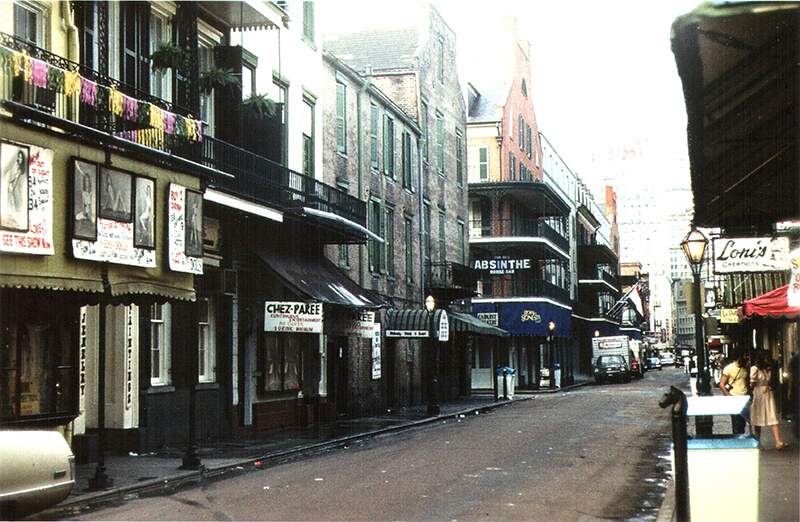
Because much of Bourbon Street's social and cultural history is a synthesis of other New Orleans histories, including Campanella's, the book's most original and compelling contribution is a delineation of the Street's changing cultural geography. Campanella chronicles several social and cultural developments that helped transform the strip: racial segregation and desegregation, the changing soundscape, the ubiquity of souvenir shops, the popularity of female public nudity, the demarcation of queer space, and the innovation of the go-cup that supplanted nightclubs and "completely rewire[d] the social and economic dynamics of Bourbon Street" (211). Campanella's meticulous archival and cartographic research draws on a wealth of primary sources—including census records, city directories, maps, and police reports—to demystify Bourbon Street and reveal its inner workings.
In his descriptions of mid-twentieth-century Bourbon Street, Campanella becomes the ultimate tour guide, immersing readers in the spectacular, cacophonous, and malodorous sensory experience of the booming vice district. He directs readers past racially stereotyped tap dancers and blackface performers on the strictly segregated Street. He offers a sneak peek at the burlesque performances—and far less glamorous dressing rooms of—Evangeline the Oyster Girl, Rita Alexander the Champagne Girl, and Alouette LeBlanc the Tassel Spinner, so named for her skill at "twirling in opposing directions four tassels attached to her breasts and buttocks" (167). Campanella introduces a colorful cast of characters, such as Gaspar Gulotta, the "Little Mayor of Bourbon Street" (146), who mediated between the various factions and personalities that held a stake in the Street's economic and cultural advancement. He takes an unexpected jaunt through Chinatown, where Chinese merchants established themselves during the Great Depression. Campanella also draws on his own primary research—interviews, photographs, observations, and painstaking analyses of pedestrian traffic and balcony occupancy—to give readers a contemporary experience. Campanella shows how by the late twentieth century, Bourbon Street had transformed from a multigenerational, ethnically and racially diverse, working-class, mixed residential and commercial milieu to a tourist strip with "fewer children, fewer blacks, fewer ethnic whites, more transplants, higher housing prices, and higher incomes" (185). Certainly, Bourbon Street's transformation had significant cultural, social, and political implications for the rest of New Orleans, particularly for the African Americans, ethnic whites, and working class families that could no longer afford to live there. But Campanella's study is less concerned with illuminating this mutuality than in promoting Bourbon Street as the quintessential American success story.
Campanella celebrates the "ethnic white working class of downtown New Orleans," whom he credits with Bourbon Street's fame and financial success. The meteoric rise is all the more commendable because it occurred with "no consolidated administration, no president, no coordinator, no lobby, no marketers, and no corporate funding. Bourbon Street as we know it today effectively invented itself, locally, from the bottom up, with each constituent entity experimenting individually and adopting innovations laterally via competitive forces" (146). This American success myth, described by film scholar Julie Levinson as incorporating "the dream of rags-to-riches, the image of the can-do American, the credo of self-reliance, the doctrine of individual enterprise, and the faith in meritocracy" is based on the faulty proposition that "we are unbound by the past, by social identities, or by economic circumstances."2Julie Levinson, The American Success Myth on Film (New York: Palgrave Macmillan, 2012), 11–12. However, Campanella's documentation of a long history of racism and sexual exploitation suggests that the exclusion and subordination of some groups, such as African Americans and women, were as integral to Bourbon Street's success as entrepreneurial experimentation and innovation. Further, Bourbon Street: A History presents myriad examples of special zoning ordinances, exemptions from code-enforcement and litigation, sympathetic task forces and commissions, disproportionate investment in infrastructure and policing, and other accommodations that subsidized economic development. As historian J. Mark Souther and others have shown, these subsidies to the city's tourist core came at the expense of other neighborhoods, "leading to the increasing spatial differentiation into privileged and disadvantaged districts."3J. Mark Souther, New Orleans on Parade: Tourism and the Transformation of the Crescent City (Baton Rouge: Louisiana State University Press, 2006), 226. Political scientist Paul A. Passavant makes a similar argument in "Mega-Events, the Superdome, and the Return of the Repressed in New Orleans," in The Neoliberal Deluge: Hurricane Katrina, Late Capitalism, and the Remaking of New Orleans, ed. Cedric Johnson (Minneapolis: University of Minnesota Press, 2011), 87–129. Campanella's own evidence undermines the free-market fundamentalist premise that on Bourbon Street "those who don't flexibly adapt to demand go bankrupt; those who survive must be effectively and efficiently giving the people exactly what they want" (303).
Campanella even attributes Bourbon's Street's post-Katrina recovery to this type of flexibility and efficiency, explaining that "brave Bourbonites incentivized the first businesses to return, and seeded the re-formation of an economy—not just Bourbon's, but that of the entire city. . . . Unlike so many other entities, Bourbon Street recovered with little if any federal aid and zero charitable assistance. Bourbon Street was not only New Orleans's most successful invention, it was also its most resilient and self-reliant" (310, 311). Yet, as scholarship on post-Katrina New Orleans chronicles, the city's market-driven approach to recovery has been unevenly and inequitably administered, exacerbating an already "uneven landscape of risk and resiliency."4Kevin Fox Gotham and Miriam Greenberg, Crisis Cities: Disaster and Redevelopment in New York and New Orleans (Oxford: Oxford University Press, 2014), viii. For other examples of recent scholarship critical of the market-driven approach to post-Katrina recovery, see Vincanne Adams, Markets of Sorrow, Labors of Faith: New Orleans in the Wake of Katrina (Durham: Duke University Press, 2013); John Arena, Driven from New Orleans: How Nonprofits Betray Public Housing and Promote Privatization (Minneapolis: University of Minnesota Press, 2012); Cedric Johnson, ed., The Neoliberal Deluge: Hurricane Katrina, Late Capitalism, and the Remaking of New Orleans (Minneapolis: University of Minnesota Press, 2011); Lawrence N. Powell, "What Does American History Tell Us about Katrina and Vice Versa?," Journal of American History 94, no. 3 (December 2007): 863–876; Lynnell L. Thomas, Desire and Disaster in New Orleans: Tourism, Race, and Historical Memory (Durham: Duke University Press Books, 2014), 158–173. Black studies scholar Clyde Woods used the apropos phrase "neo-Bourbon/neoliberal agenda" to refer to the political, social, legal, and economic policies that created and maintained this landscape that prioritized tourism interests and private profits over community needs and social justice initiatives.5Clyde Woods, "Katrina's World: Blues, Bourbon, and the Return to the Source," American Quarterly 61, no. 3 (2009): 448. Bourbon Street: A History rejects this type of criticism and sets up a rigid binary between those who appreciate Bourbon Street as "a delectable mélange of historicity and hedonism" and haters who view it as "iniquitous, crass, phony, and offensive" (xiii). This reductive pro-/anti-Bourbon framework elides the complicated, reciprocal processes of touristification and criminalization that prompts investment in tourist spaces and containment of other neighborhoods.6Passavant, "Mega-Events, the Superdome, and the Return of the Repressed in New Orleans."
Although Campanella claims to offer "a nonjudgmental analysis of a complex phenomenon from many angles" (xvi), he levels his most strident criticism against "the cultural elite and their aspirants—image-conscious doyens, urbanophiles and preservationists, literati and academics, music connoisseurs and foodies, insecure transplants proving their bona fides, college students making a statement" (297). Their disdain for Bourbon Street, Campanella maintains, rests on elitist and ahistorical notions of authenticity. In contrast, Campanella proposes a relativist notion of authenticity: "Everything is real. Bourbon Street today is just as authentically part of real New Orleans culture as Storyville was a hundred years ago, and as Social Aid and Pleasure clubs, the housing projects, Creoles, and Tremé are today – no more, no less" (300). Yet, Campanella's authority to determine what is real and who is qualified to judge that reality rests, in part, on his own status as a New Orleans insider whose experiences trump the criticisms leveled by the progressives he disparages.7For an analysis of the implications of Campanella's privileging of experience-knowledge, see Emma Lirette, "Category 3 Gentrification: On New Orleans's Population Trends and the Hostility of Internet Commenters," Southern Spaces, April 17, 2013, https://southernspaces.ecdsdev.org/blog/category-3-gentrification-new-orleanss-population-trends-and-hostility-internet-commenters.
Campanella's characterization of black New Orleanians is as problematic as his sweeping condemnation of progressives. Working-class African Americans escape the pitfalls of the authenticity debate because they supposedly "have all the authenticity they need" (297). In a similarly puzzling assessment, Campanella categorizes local nonwhites on Bourbon Street who are neither working in one of the establishments nor passing through on the way home, as being there to "loiter, beg, bicker, and settle scores among each other" (266). One is left to wonder about the experiences of local African Americans (and other groups) who go to Bourbon Street to witness the spectacle and indulge in the free entertainment, those who visit with out-of-town guests, socialize with attendees at black conventions and festivals, celebrate during Mardi Gras or after Saints games, or—as my own son did recently with a group of local black college-age friends—bring in the New Year. While Campanella offers the perspectives of informants who stereotype all black patrons as poor tippers, enact racially discriminatory policies, and deride an outing with high black turnout as "ghetto night" (273), he rarely presents the voices of black New Orleanians or black tourists or examines their complicated relationship to Bourbon Street.
Campanella does an excellent job of mapping "geographies of pleasure" (99) that have made the tourist promenade such a central part of New Orleans's economic and cultural identity. What the senseless Bourbon Street shooting death of African American tourist Brittany Thomas illuminates is that these geographies of pleasure are inextricably linked to the geographies of pain that have also powerfully shaped the city's economy, geography, and historical memory.8By a cruel irony, the June 2014 Bourbon Street shooting occurred just outside Johnny White's bar, the same bar that famously stayed open during and after Hurricane Katrina. The fact that this Bourbon Street institution has served as both a symbol of the city's rebirth and a reminder of its rampant violence and criminalizaton highlights the relationship between geographies of pleasure and pain. See, Benjamin Alexander-Bloch, "Bourbon Street Shooting Sent Bystanders Rushing into Nearby Businesses," NOLA.com, June 29, 2014, http://www.nola.com/crime/index.ssf/2014/06/as_bourbon_street_shooting_occ.html; Richard Campanella, Bourbon Street: A History (Baton Rouge: Louisiana State University Press, 2014), 310.
About the Author
Lynnell Thomas is associate professor and chair of American Studies at the University of Massachusetts Boston. Her research interests include New Orleans tourism, popular culture, and African American history and literature. A native of New Orleans, Lynnell Thomas is part of the post-Katrina diaspora, which informs her teaching and scholarship. Her research is also concerned with the diverse backgrounds and experiences that constitute and contest American identity and values. Her most recent scholarship has examined post-civil rights era tourism, the HBO series Treme, and post-Katrina New Orleans.
]]>Review
 |
The image on the front cover of New Deal Ruins reverberates prophetically. In March 1972, after only two decades of occupancy, the first of Pruitt-Igoe's thirty-three public housing towers came tumbling down in St. Louis, Missouri. Looming over heaps of wires, steel, and concrete slabs, other hollowed out high-rise buildings awaited similar destruction. Overlooked as a place where low-income black people made a living for themselves and their families, Pruitt-Igoe was instead regarded as dangerous, impoverished, and ultimately beyond saving.
Over forty years later, this perception reigned not only in the case of Pruitt-Igoe, but also inflected the reception and treatment of other public housing complexes in cities across the country.1The Pruitt-Igoe Myth, directed by Chad Freidrichs (Columbia, MO: Unicorn Stencil Documentary Films, 2011). Today, public housing has become a trenchant symbol of failure. By the late 1970s, low-income black people who resided disproportionately in public housing were often perceived as problem tenants. And the vision of public housing (at least by some housing reformers) as an affordable option for the worthy poor was replaced by caustic images of obsolete incubators of anomie that drained cities of their worth. This inexact narrative has been so dominant that the view of public housing as disastrous, and therefore in need of extensive demolition, has prevailed as an almost unassailable and foregone conclusion.
In New Deal Ruins, political scientist Edward G. Goetz treats public housing differently. He tells a more complicated story: one that encompasses competing narratives of place, interests of the public and private sectors, and conceptions of space undergirded by shifting ideological, moral, and political economies. More specifically, Goetz examines public housing reforms since the 1990s and assesses their impact on people and cities. He begins by exposing how a "discourse of disaster" has legitimated the demolition and disposition of public housing as a primary, if not requisite, strategy for private sector urban reinvestment and vitality. Goetz explains how this approach has emerged as the new "urban planning orthodoxy." This orthodoxy ultimately reveals a trend toward market-driven "reforms" and belies "the reality … that in most places [public housing] worked—and still does work" (2).
 |
| Pruitt-Igoe demolition, April 22, 1972. US Department of Housing and Urban Development. Courtesy of Wikimedia Commons. |
To bolster his claim, Goetz refers to a 1992 report commissioned by the US Department of Housing and Urban Development (HUD) that maintained that 94 percent of public housing units were not severely distressed. Unfortunately, the discourse of disaster, fed by "popular press accounts of the worst public housing in our largest cities," such as Chicago, better served neoliberal policy agendas that privileged the market and increased privatization (2). As a result, despite the commission's recommendations that called for investment in existing public housing and the one-to-one replacement of demolished units, HUD policies ultimately helped rid cities of public housing complexes. In the process, HUD began to relinquish oversight, management, and financial controls to the market and private entrepreneurs. It was in this political context that the promise of the HOPE VI program, which emphasized building mixed-income housing, became one of the signal tools in HUD's arsenal to demolish and dispose of over one-quarter million public housing units.2This is ironic given that the public housing program was established, in part, because the private sector could not meet the needs of the lowest income tenants—either in quantity or affordability of rental units. This has not changed. Even as HUD approved the demolition and disposition of public housing apartments, the waiting lists for public housing units were in the hundreds of thousands. Moreover, the HUD report on "Worst Case Housing Needs"—sent to Congress in 2010, the same year HUD approved the demolition and disposition of an additional 285,000 apartments—identified 6 million people in dire need. This was an 18 percent increase in just one decade. In this context, as Goetz writes: "The dismantling of public housing makes little sense as housing policy" (177).
By the end of the twentieth century, public housing as state-owned residences increasingly devolved into urban ruins. Simultaneously, racial and economic landscapes were reconfigured. As local housing authorities demolished public housing, primarily black residents found themselves experiencing a late twentieth- and early twenty-first-century version of "Negro removal."3"Negro removal" was a phrase used to describe the disproportionate displacement of black people from neighborhoods targeted for urban renewal. "Urban renewal," writes Goetz, "displaced an estimated one million people from the time of its enactment in 1949 to 1965… So, too, the development of the interstate highway system, as it carved its way through central cities, tended to disrupt largely black areas, displacing families and disrupting communities" (112). In the wake of massive demolition of public housing, tenants initiated efforts to preserve decades of memories. In Chicago, for example, longtime residents Deverra Beverly and Beatrice Jones, who feared their presence would be forever erased, supported the establishment of the National Public Housing Museum. According to Goetz, both women wanted their children and grandchildren to know public housing "existed as a community" (2).
One of the numerous contributions of Goetz's New Deal Ruins is its examination of the shifting political economy and federal and local government practices that led to the transformation of public housing as a physical place and as a state program. By the 1990s, the narrative of disaster and the rise of neoliberal governance had contributed to not only the dismantling of local public housing programs, but also to exposing an equally parallel hostility to the welfare state. Goetz argues, this "radical remaking of public housing" marked by a turn to market-driven policies heralded "an important watershed moment in American domestic policy" (ix). To be sure, public housing is not the only publicly funded institution to be impacted by the trend toward privatization. The growth of privately managed charter schools, privatized prisons, and low-income housing (and school) voucher programs serve as other examples.4For instance, see Pauline Lipman, New Political Economy of Urban Education: Neoliberalism, Race, and the Right to the City (New York: Routledge, 2011); Diane Ravitch, Reign of Error: The Hoax of the Privatization Movement and the Danger to America's Public Schools (New York: Knopf, 2013). On prisons, see Michele Alexander, The New Jim Crow: Mass Incarceration in the Age of Colorblindness (New York: New Press, 2012); Rhonda Y. Williams, "'We Refuse!': Privatization, Housing, and Human Rights," in Freedom Now! Struggles for the Human Right to Housing in L.A. and Beyond, eds. Christina Heatherton and Jordan T. Camp (Los Angeles: Freedom Now Books, 2012). While reigning ideology holds that the unfettered private market is better positioned to address social inequality, it has not necessarily lessened the government's financier role. Instead, public tax dollars subsidize private sector urban redevelopment efforts. This holds true not only for housing, but also for schools and prisons.
The relationship between post-recession 1990's economic pressures to stimulate private-sector development and efforts to de-concentrate poverty in inner cities is critical to this story of neo-liberalizing the public housing program. Goetz mobilizes the tales of three cities, Chicago, Atlanta, and New Orleans, to illustrate the intersection of these competing pressures. In all three cities, public housing targeted for demolition or disposal occupied or bordered valuable downtown property. "Race and gentrification pressures," observes Goetz, "are important in determining the aggressiveness with which cities pursue the transformation of public housing" (49). Recapturing valuable property for private development not only gained a quick hearing among many local officials, but regularly took precedence over residents' demands for the right to remain in, return to, as well as improve the living conditions in their housing complexes or neighborhoods.5Contemporary "Right to the City" movements seek to counteract such displacement and the demise of affordable, safe, and adequate public housing. See, for instance, David Harvey, Rebel Cities: From the Right to the City to the Urban Revolution (New York: Verso, 2012) and the New York-based, national Right to the City Alliance that emerged in 2007 as a housing and urban justice movement.
 |
| Aerial view of Clark Howell Homes, center, Techwood Homes, left, Georgia Institute of Technology, bottom. Atlanta, Georgia, circa 1940. Photocopy of photograph. Library of Congress Prints and Photographs Division, HABS GA,61-ATLA,63--2. |
 |
| View of playground behind Building X, from west facing east, Techwood Homes. Atlanta, Georgia, circa 1940. Photocopy of Photograph. Library of Congress Prints and Photographs Division, HABS GA,61-ATLA,60--16. |
 |
| West front elevation, Techwood Homes, Building No. 2. Atlanta, Georgia, June 1993. Library of Congress Prints and Photographs Division, HABS GA,61-ATLA,60D--1. |
These locally driven agendas document that public housing was not without its problems. Programs suffered from "mismanagement, underfunding, poor design, and civic neglect" (1). New Deal Ruins reminds—or informs—us that tenants were well aware of and attentive to these problems. They also knew that some public housing complexes did not provide safe environments to raise children, leading many to form tenants' groups and protest against housing and city officials. Despite recent scholarship, their experiences and protestations remain largely unsung and undervalued as critical components of the public housing story.6See, for instance, Roberta M. Feldman and Susan Stall, The Dignity of Resistance: Women Residents' Activism in Chicago Public Housing (Cambridge: Cambridge University Press, 2004); J. S. Fuerst and D. Bradford Hunt, When Public Housing Was Paradise: Building Community in Chicago (Chicago: University of Illinois Press, 2005); Lisa Levenstein, A Movement Without Marches: African American Women and the Politics of Poverty in Postwar Philadelphia (Chapel Hill: University of North Carolina Press, 2010); and Rhonda Y. Williams, The Politics of Public Housing: Black Women's Struggles against Urban Inequality (New York: Oxford University Press, 2004). There is a lesson here: We must understand how the power of public memory and narrative disparately shapes and exposes our understanding of people, spaces, and policies. To be sure, even explicitly revealed narratives (like campaign promises or, more aptly, policy rationales) can still cover up intentions, fail to capture multiple agendas, or conceal dynamics of power. A key argument in New Deal Ruins is that the narrative of improving the lives of residents and de-concentrating poverty often camouflages privatization and development schemes.
By the dawn of the twenty-first century, urban transformation agendas across the country did not provide enhanced resources to tenants while they still lived in public housing. "The irony of the Chicago case," writes Goetz, "is that the considerable achievements in coordinating city services were realized in public housing communities only after their demolition. For most of its history, public housing in Chicago was not a priority for public officials" (88). What had become a priority by the end of the twentieth century was inner-city revitalization in the form of gentrification. In Chicago, this approach led to the overwhelming elimination of public housing and the removal of low-income black people from areas of new investment. Atlanta public housing shared a similar fate once officials decided to build the Olympic village across from Techwood Homes. Completed in 1935 as the nation's first public housing complex and later nominated to the National Register of Historic Places, Techwood Homes followed "a classic pattern of de facto demolition" (102). With the housing authority failing to fill vacancies and using its depleted tenant rolls as justification, the city demolished Techwood Homes in 1993. Similarly, redevelopment pressures in New Orleans hastened the decline of public housing, which had become 100 percent black by 2005 (98). The Iberville Homes sat on appreciating land near the French Quarter and Louisiana State University's planned biomedical and hospital complex. For business leaders, Iberville's "elimination" represented "the centerpiece" of "responsible redevelopment." Its demolition also marked the end of an era: "a complete shift away from traditional public housing in the city" (97). Goetz's attention to the demise of these New Deal-era public housing programs reveals how the politics of location, shaped by historical racial and class-based inequalities, become reinforced in the present.
Local histories, inflected by what Dolores Hayden terms "the power of place," also shaped the political process that led to displacement and redevelopment.7Dolores Hayden, The Power of Place: Urban Landscapes as Public History (Cambridge, MA: MIT Press, 1995). Hayden discusses place as "one of the trickiest words in the English language" that "carries the resonance of homestead, location, and open space in the city as well as a position in a social hierarchy" (16). Hayden further discusses how deep examinations of place reveal contested terrains and the production of space—both of which reveal perceptions and values, historical contexts, and political economy. In Chicago, historic racially-discriminatory siting policies and decades of mismanagement helped to create the conditions in which the late twentieth-century Plan for Transformation emerged. In Atlanta, new political leadership at the municipal level—including a new mayor, Bill Campbell, who appointed Renee Glover, a former corporate finance attorney, CEO of the housing authority in 1993—sidelined the previous mayor's initial commitment to rehabilitate and renovate public housing. Demolition became the strategy, one that expanded exponentially when Atlanta secured the Olympics (103). In New Orleans, local officials took advantage of the man-made disaster that accompanied Hurricane Katrina to advance an agenda guided, in part, by the federal government's new predilection to privatize public housing (93). The hurricane and its temporary displacement of public housing tenants—all of them black—provided an opportunity for local officials to demolish complexes and racially and economically remake urban space.
 |
| St. Thomas Street: the before photo. View shows street view prior to the demolition that cleared the area for the St. Thomas Housing Project. New Orleans, Louisiana, circa 1939. Photograph by US Housing Authority. National Archives and Records Administration, 196086. |
 |
| St. Thomas Street: the after photo. View shows completed St. Thomas Housing Project, circa 1940–1941. Photograph by US Housing Authority. National Archives and Records Administration, 196087. |
Proponents of alleviating spatially concentrated poverty also supported the move toward government backing of private-sector redevelopment initiatives. For instance, civil rights attorney Alexander Polikoff described HOPE VI mixed-income developments as "a hopeful and important step in the direction of de-concentrating poverty."8Goetz, 5. Also see, Rhonda Y. Williams, "Race, Dismantling the "'Ghetto,'" and "Housing Mobility: Considering the Polikoff Proposal," Northwestern Journal of Law and Social Policy 1, no. 1 (Summer 2006), http://www.law.northwestern.edu/journals/njlsp/v1/n1/4/. Yet, as Goetz poignantly maintains, de-concentrating poverty is not the same as altering the economic conditions of low-income residents. Across the country, where the de-concentration of poverty occurred, it was not necessarily because poor people were no longer poor. The new orthodoxy of urban planning helped to relocate poverty and to continue a longstanding racial practice—displacing primarily black people for the sake of broader development agendas that rarely benefited them in substantive, sustained, or collective ways.
Moreover, according to Goetz, race unquestionably played a significant role in determining which complexes met their demise and which were left standing. "In city after city," the complexes torn down "have had significantly higher percentages of African American residents than those left standing in the same cities" (112). This was not simply because a disproportionate percentage of black people lived in public housing, or because public housing existed disproportionately in minority neighborhoods. Instead, New Deal Ruins documents this inequality, arguing forthrightly, "In cities where public housing is most associated with black tenants, it is most likely to be demolished " (178-179, italics added).
Goetz's multi-layered analysis of housing policy and redevelopment explicitly examines black removal from urban spaces and the perpetuation of racialized poverty. In these ways, Goetz does not fail—as discourses of disaster often do—to present public housing residents as real people. Despite the challenges inherent to their spaces and places of living, residents nevertheless experienced personal hardships and joys, made families and memories, engaged in activism, and expressed their viewpoints—including their differing opinions on the fate of their subsidized residences. This was true in Baltimore and cities across the country where implosion became the policy of choice.
For my book, The Politics of Public Housing, I remember interviewing two tenant activists in Lexington Terrace, one of four family high-rise public housing complexes slated for demolition in the inner city of Baltimore in the 1990s. Lorraine Ledbetter expressed hope that the implosion of Lexington Terrace would benefit residents. Barbara "Bobbie" McKinney, however, vociferously disagreed. McKinney believed that residents were merely viewed as obstacles in the path of redevelopment, not potential beneficiaries. Reading New Deal Ruins, I recalled the day that I sat in Bobbie's apartment and she shared her fear and anger that the support networks and sense of community forged by tenants—even amid the dangers they had to navigate—would be destroyed and never replaced.9Goetz, 128. Also see, Rhonda Williams, The Politics of Public Housing; "'I'm a Keeper of Information': History-Telling and Voice," Oral History Review 28, no. 1 (Winter/Spring 2001): 41–63. Such laments about displacement, similarly expressed by public housing residents in post-Hurricane Katrina New Orleans, Atlanta, Chicago, and elsewhere, exemplify what Mindy Fullilove has described as "root shock."10Mindy T. Fullilove, Root Shock: How Tearing Up City Neighborhoods Hurts America, and What We Can Do about It (New York: Ballantine Books, 2005).
In the late 1990s and the first decade of the twenty-first century, public housing residents protested privatization, demolition, and displacement. Their protests also had local parlances—not surprisingly, given the immediate political contexts they confronted. In Chicago, tenants formed the Coalition to Protect Public Housing (CPPH) to organize demonstrations, prevent evictions, challenge de facto demolition policies, and fight for one-for-one replacement of public housing units. In New Orleans, residents unsuccessfully waged a two-year resistance campaign to prevent closure of their complexes. There, the state played a role in the residents' eventual defeat: SWAT forcibly evicted protesting tenants, and HUD threatened to withdraw promised housing vouchers if the city council gave into tenants' demands (95). In Atlanta, tenants in specific complexes sued for improved relocation initiatives, and in response to the Atlanta Housing Authority's wholesale demolition agenda, which included senior buildings, the resident advisory board filed a civil rights complaint evoking the Fair Housing Act of 1968 (107). In all three of these cities (and many others), resident activists felt shunted to the side to advance the interests of business and political elites.
.") |
| Fair Development Campaign protest of Harbor Point development, Baltimore, Maryland, July 17, 2013. Photograph by Flickr user United Workers (CC BY 2.0). |
While reasonably arguing that the experiences of those forcibly removed "defy easy generalizations, either positive or negative" (127), Goetz maintains that the "demolition of public housing has for the most part not produced significant or consistent benefits for the very low income families displaced" (150). Ultimately, he concludes that public housing policy, which claims to improve the conditions of low-income people, has been "hijacked to serve a development agenda that had a different set of objectives, objectives focused on the dispersal of low-income residents, the elimination of public housing communities, and the facilitation of private-sector reinvestment in urban areas that had been in that respect neglected for decades" (181). The cautionary message is clear: place-based, private (or public) redevelopment, even in the name of improving low-income residents' conditions, will not automatically or necessarily benefit them. When it comes to public housing redevelopment, in particular, success must be measured in one signal way: "The record…in delivering benefits to the original residents is a critical context for any summary judgment of transformation policy since 1990" (175). On this score, the record fails.
New Deal Ruins concludes with general recommendations for ending policies that extend racial and economic injustices. Goetz argues that preserving a state-owned, managed, and supported public housing program does not mean maintaining ineptness, mismanagement, or un-defensible low-income apartments. Demolition and disposition can no longer serve as the unthinking solution. Governments should support programs for those who want to stay and those who want to move, replace each unit demolished, and, overall, expand affordable residential options. "False choices," egregiously made on the backs of the nation's poor people, particularly African Americans, must not rule the new day.
About the Author
Rhonda Y. Williams is an associate professor of history and founder and director of the Social Justice Institute at Case Western Reserve University. She is the author of Concrete Demands: The Search for Black Power in the 20th Century (New York: Routledge, 2015). Her book The Politics of Public Housing: Black Women's Struggles Against Urban Inequality (New York: Oxford University Press, 2004) won the Letitia Woods Brown Memorial Book Award from the Association of Black Women Historians. Williams is also co-editor of Teaching the American Civil Rights Movement: Freedom's Bittersweet Song (New York: Routledge University Press, 2002); Women, Transnationalism and Human Rights, a special issue of Radical History Review 101 (Spring 2008); and editor of a new book series Justice, Power, and Politics with University of North Carolina Press.
]]>