Video
Essay
Jeff Drew, born in 1951, is a lifelong resident of Birmingham, Alabama's North Smithfield neighborhood. In 2013, following the fiftieth anniversary commemoration of the Birmingham campaign of the civil rights movement, Drew was inspired to be his neighborhood's oral historian: "The people who can tell the story are dying off."
Long before Birmingham was a center of 1960s movement protest, the hilly residential street where Drew grew up and still resides was a battleground in the fight against segregation. In the 1940s, Center Street was the dividing line between white and Black property: white residents on the west side and Black residents on the east side. Ignoring Jim Crow, Drew's family and other Black families crossed the color line and built homes on the west side of Center Street. Between 1947 and 1965, Black residences in Birmingham were bombed at least fifty times.
A graduate of Morehouse College in Atlanta, Jeff Drew's father, John (1908–1991), co-founded the Alexander Insurance Agency with the mission of providing affordable insurance to Black customers. While a Morehouse student, John Drew met Alfred Daniel King, Dr. Martin Luther King, Jr.'s brother. Participants in the Montgomery bus boycott in 1955–56 faced a dilemma: retaliating against Black protestors' refusal to ride the busses, the city imposed higher car insurance fees. When Dr. King asked his brother if he knew anyone who could help, Alfred connected him with John Drew, beginning a relationship that would last until Dr. King's assassination.
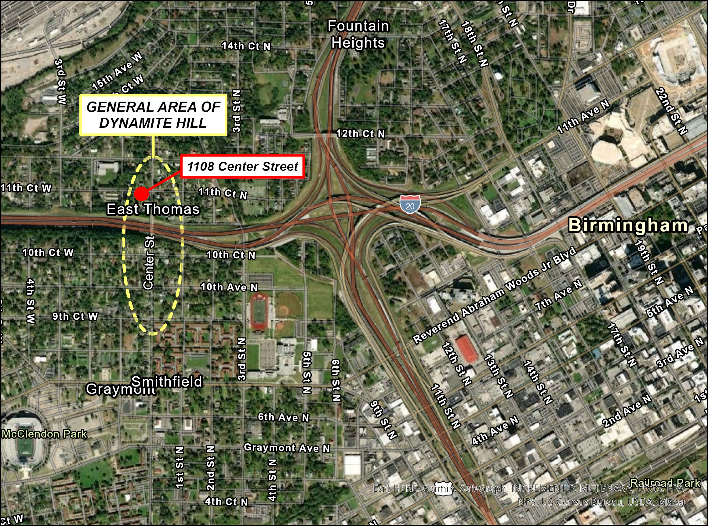
John Drew and Dr. King, along with local Birmingham civil rights leaders such as Fred Shuttlesworth and Arthur Shores, worked closely together to tear down Birmingham's segregated zoning ordinances, paving the way for Black families to live on the west side of Center Street—but not without brutal backlash. The area was bombed so frequently it became known as "Dynamite Hill," in a city already dubbed "Bombingham." Led by the Ku Klux Klan, assailants took to the cover of night to throw bombs, burn doors, and shoot into homes.
Atop Dynamite Hill, the Drew household was a high priority target for domestic terrorism because it was also a safehouse for civil rights organizing. Addine Drew (1916–2003), Jeff's mother, was known as the "Den Mother" of the movement. The trust between the Drews and Dr. King was so strong that he would stay with the family when in Birmingham. Local Black leaders would meet at 1108 Dynamite Hill to plan the next moves for equality. Jeff Drew tells of his childhood in this space, how he spent nights listening in on strategic conversations and woke up to find Dr. King sleeping on the couch. Given the profiles of those in attendance, these meetings were difficult to keep secret, so they were constantly under assault.
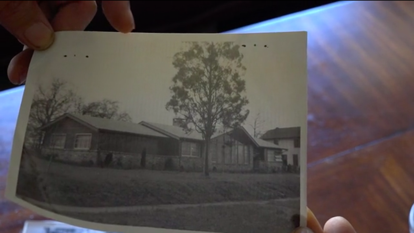
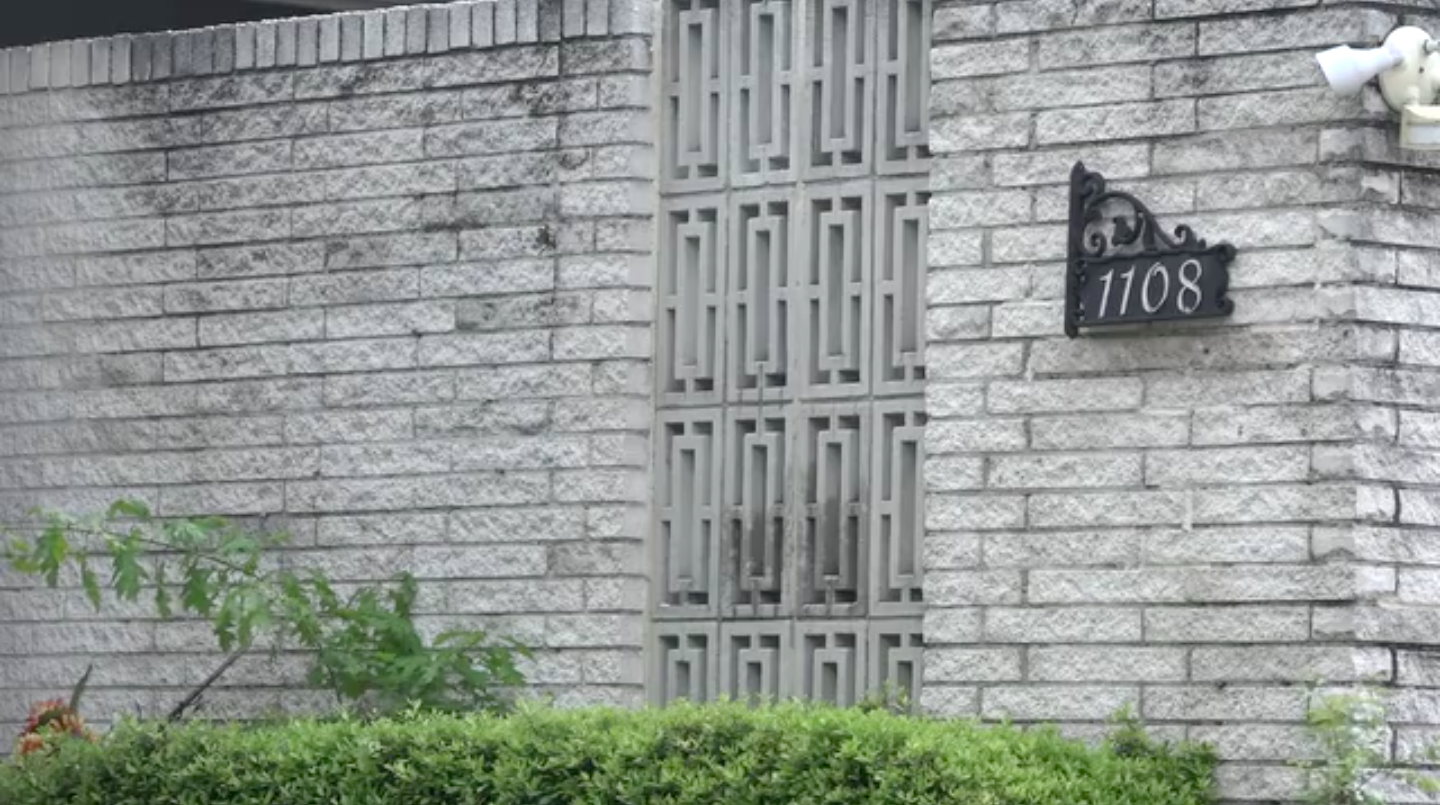
The original street-facing window of 1108 was a grand, cathedral-style frame—a colossal opening into a living room where the organizers met. Shot at and shattered countless times, the scenic window now only exists in photographs. After sustaining several bombings and much gunfire, the Drews had the home rebuilt with a new structure designed to endure bomb blasts. They constructed eight-foot tall brick walls that encased the perimeter of 1108 and reconfigured the interior so that the bedrooms were the furthest away from the street. The walls held and have endured, with the scars of attempted murders visible on the bricks.
The opportunity to hear Jeff Drew's story is a recent development. After Birmingham's 2013 commemoration, Drew told reporters that his parents asked him to never give interviews about "Uncle Mike" for fear that the white press would seek to tarnish his legacy and that of other local Black activists. With time, and the passing of many 1960s movement participants, Drew decided that he would talk more about this history. Seeing Drew outside 1108 talking to whoever will listen is as ordinary as seeing the mail being delivered. The only time he might turn down a conversation would be under similar circumstances to when he had us reschedule: he had a lunch date with childhood neighbor Angela Davis. 
Acknowledgements
Special thanks to Jeff Drew for treating strangers like neighbors and taking the time to share his essential story.
About the Authors
Joseph Quintana earned his MA in Communication Studies from the University of Alabama in 2019. He recently received a screenwriting certificate from NYU Tisch School of the Arts and is currently pitching prospective screenplays and researching documentary subjects.
Mary Campbell Kitchens is a graduate from the University of Alabama and works as a secondary math special education instructor in New Orleans, Louisiana.
]]>Blog Post
I recently bought a crumbling old house in a historically gay neighborhood in Roanoke, Virginia. I met my ex-lover in this house five years ago. At the time they lived with a coterie of other young people. They threw raucous queer parties and housed folks who didn't have anywhere else to go.
A few blocks down the street is another building. There, in 1971, a group of young men and women founded the Gay Alliance of the Roanoke Valley (GARV), the region's first gay liberation organization. This building is now a medical office. I come here once a year to see my endocrinologist. He prescribes spironolactone and estradiol to help my body transform into something approximating that of a woman.
The local neighborhood association puts up signs that read, "A Past with a Future." As I see it, the neighborhood's past is rich with gay history, and the future is my transitioning body and the pink, white, and blue flag I fly in the driveway.
Queer history lives here. It's overlapping in the spaces of my neighborhood. It's in the bones of the buildings. Queer ghosts inhabit the walls. Archaeological troves are remnant in the yards. My dog June digs them up with her ready paws and pearl-white fangs. My gender transformation is hitched to the woodwork and to the water pipes of all the apartment buildings where I have lived. People have lived queerly in these spaces. I have bought a home that not only holds the past but makes space for the future—for my womanhood, my motherhood, and for the chosen family I will assemble underneath this roof.
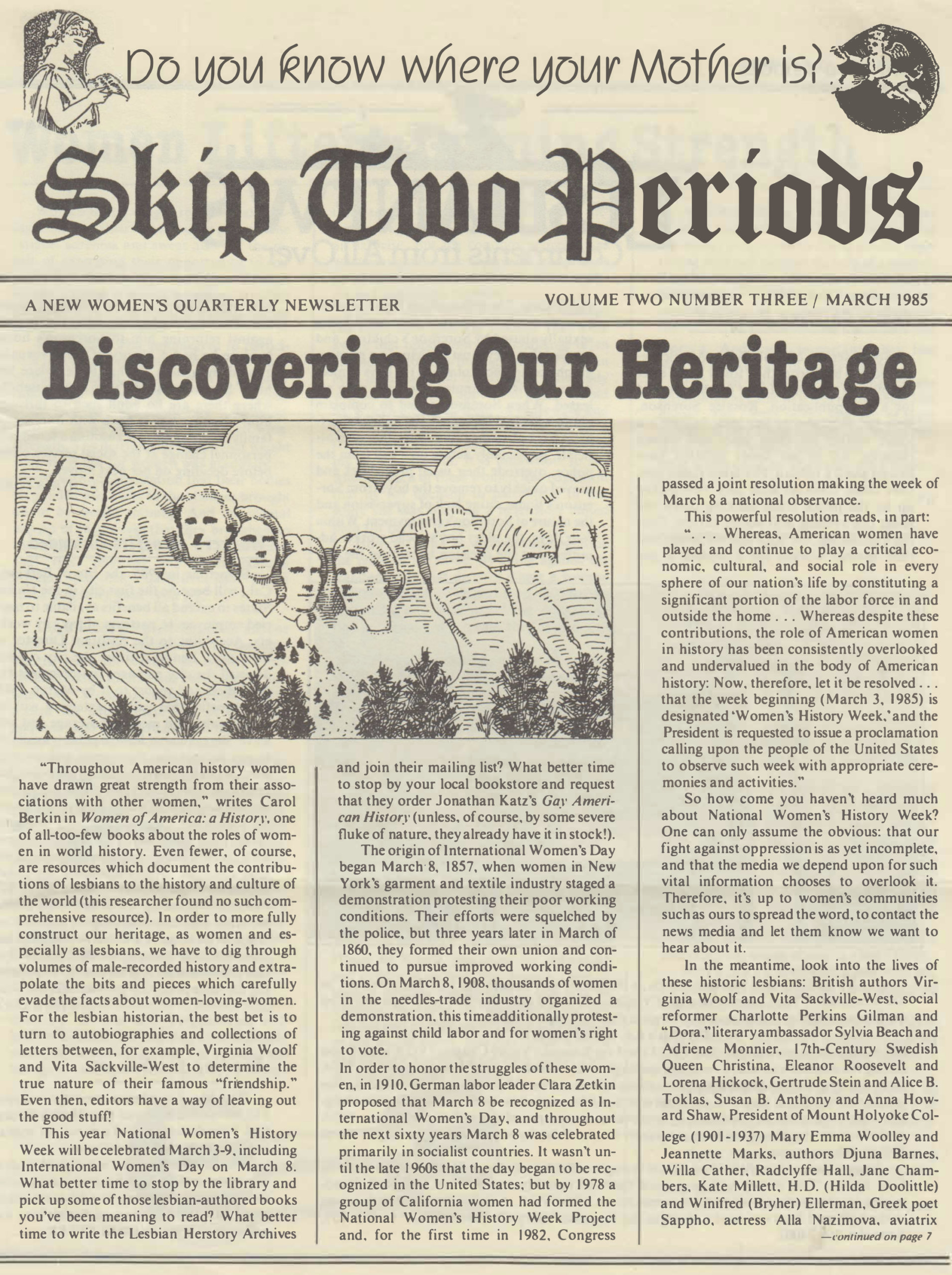
LGBTQ people have long known that our stories are not to be found in the so-called annals of history, and that we have to look in unexpected places to find our past. Lesbians in Roanoke in the 1980s devoted an entire issue of their newsletter, Skip Two Periods, to "Discovering Our Heritage." The writer, "B. F.," wrote about finding her heritage at the Lesbian Herstory Archives in Brooklyn, in Jonathan Ned Katz's book Gay American History, through the National Women's History Project, and in the published letters shared among nineteenth-century women. She also suggested that lesbian history is found in our families. "Write to your grandmother and ask her about her grandmother," she pleaded. Indeed, queer history is present in the way my parents reacted when I first came out, as they referenced a family member who died of AIDS in 1989 and hinted that I might face a similar fate. We carry queer trauma in our bodies. All of us—straight, gay, cis, trans—live in a world shaped by the queer past.
We have the tools to probe this history on the local level. Since the 1970s, queer history projects have flourished across the United States. New archives are forged from the remains stowed away in activists' attics and closets. Oral history collections are assembled from the stories of our elders, talking about what it was like growing up as a trans person in Appalachia in the 1960s, for example. Doing queer history work provides us with the opportunity to bring LGBTQ people together across generations, to talk about what was and what can be, to find new meaning in the spaces of our lives.
Six years ago, I helped found the Southwest Virginia LGBTQ+ History Project, a community history project that has since engaged hundreds of local people in the process of researching and interpreting queer pasts. This has involved creating a permanent archive in partnership with the local public library system, developing an oral history collection through interviews with our elders, leading monthly walking tours, unveiling digital exhibits, releasing podcasts, and working with local youth on interactive theater and zine-making workshops. This project is how I ended up spending time in this house; it's where I fell in love with a project member who lived here. It's how we know the geography of bars and cruising spaces that once littered the neighborhood, and the all-queer and all-trans houses that still stand. It's how I discovered my gender. Interviewing trans women about their lives, I realized this was also my story. So I came out into the spaces of the project, into the spaces of our city, into a new relationship with queer history. A past with a future.
Every October we celebrate LGBTQ History Month. To me, this month is a reminder that we are still fighting, especially here in the South, for students' right to learn basic LGBTQ history in the classroom. But beyond the metanarrative of what should be taught in school, there are thousands of local queer histories still waiting to be uncovered. This work takes all of us—students, elders, volunteers, professionals. Do you know when the first gay organization was founded in your community? Have you met your trans elders? The work of doing queer history has the power to transform lives. It has the power to give new meaning to the places we call home.
About the Author
Gregory Samantha Rosenthal is the author of Living Queer History: Remembrance and Belonging in a Southern City (Chapel Hill: University of North Carolina Press, 2021).
]]>
After the end of the Civil War, recently freed Black people endeavored to create their own communities. During Reconstruction, and with newfound access to political and economic power, Black towns and institutions emerged wherever Black people lived. Before the end of the Civil War, Union soldiers defeating Confederate soldiers attracted emancipated Black people, who settled near Union encampments. In 1865, and immediately after the end of the Civil War, at a former encampment situated across from the town of Tarboro, North Carolina, and within the floodplain of the Tar River, the land was dubbed Freedom Hill. Twenty years later, a Black community elder named Turner Prince purchased the land, and it was renamed Princeville, the first incorporated Black town in America.1Joe A. Mobley, "In the Shadow of White Society: Princeville, a Black Town in North Carolina, 1865–1915," North Carolina Historical Review 63, no. 3 (1986): 340–84.
Though Princeville may look like other rural towns in eastern North Carolina, it carries significant histories. Shiloh Landing marks the point along the Tar River where enslaved peopled disembarked into brutal lives of forced labor and captivity. Another riverfront site was later accessed by congregants of local churches, arriving in white-robed processions to perform baptismal ceremonies. Princeville, from its infrastructure to its buildings and landscapes, was self-built by Black residents. Many residents were engaged in the timber and mill industries and located their businesses and homes close to the Tar River, built on stilts to help them survive frequent flooding. Powell Park now marks this area and its emotionally charged history—five major floods inundated the town in the twentieth century. Hurricane Matthew ravaged the town in 2016. Princeville's endurance to rebuild in the face of these devastations has made it especially remarkable.

Princeville was socially as well as environmentally vulnerable, due to racism and the sustained threat of white supremacist violence from nearby communities. Despite these risks, Princeville's population continued to grow, and does so to this day. As an indicator of the place attachment expressed by residents, the town's population increased after the rebuilding periods that followed numerous floods.
Like Princeville, the town of Mound Bayou, Mississippi, also came about by untraditional circumstances. It originated from the enslaved African community of Davis Bend, Mississippi, which was created, in the 1820s, by slave-plantation owner Joseph Davis as a "model" slave community on a plantation. By the standards of America's Peculiar Institution, Davis provided a relatively high level of social, health, and economic care, as well as independence, to Davis Bend's inhabitants. Although still enslaved, residents benefited from dental and health care, opened and ran merchant businesses, and were spared overt domination from overseers. After the Civil War and the collapse of cotton prices, Davis Bend failed, and its residents relocated to the Mississippi Delta bottomlands to found Mound Bayou in 1887. The town earned regional notoriety for its numerous Black owned businesses and organizations, as well as for its tradition of protecting Black people's voting rights amid racial violence. The relative success of the town earned accolades from Booker T. Washington, who called it a model of "thrift and self-government."2Melissa Block, "Here's What's Become of a Historic All-Black Town in the Mississippi Delta," Our Land, National Public Radio, March 8, 2017, www.npr.org/2017/03/08/515814287/heres-whats -become-of-a-historic-all-black-town-in-the-mississippi-delta.
Mound Bayou suffered from declining cotton prices and an uptick in Jim Crow–era oppression. The town distinguished itself, however, by providing safe harbor for Black people seeking modest political and economic independence. Serving as a key organizing ground for the Regional Council of Negro Leadership, Mound Bayou attracted interest from prominent civil rights leaders like Medgar Evers. Regional boycotts, in 1952, of service stations and restrooms refusing to serve Black people were organized in Mound Bayou.3Peter Brown, "Strike City, Mississippi," Anarchy 7, no. 2 (1967): 33–37. And, in 1955, the town served as a safe harbor when Black reporters came to Mississippi to cover Emmett Till's murder trial.4Olive Arnold Adams, Time Bomb: Mississippi Exposed and the Full Story of Emmett Till (Mound Bayou: Mississippi Regional Council of Negro Leadership, 1956). Mound Bayou continues to exist today, though it grapples with the numerous contemporary challenges facing rural southern towns, including population decline and reduced economic opportunities.
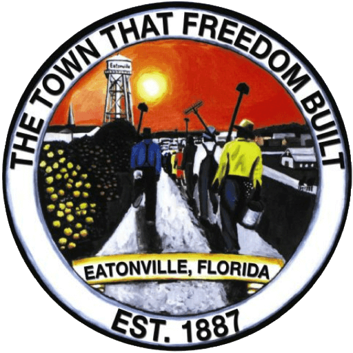
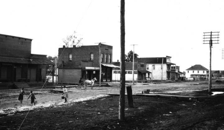
Eatonville, Florida, also founded by Black Americans in 1887, represents not only the historical significance of free Black towns but also the contemporary roles Black landscape architects can play in their protection and growth. Eatonville emerged from the lack of human rights protections afforded to Black Americans in the post-Reconstruction era. Named after a white landowner, Joseph Eaton, who was willing to sell land to Black people, the town was originally located on just over one hundred acres in what is now known as Greater Orlando.5United States Department of the Interior, National Park Service, "National Register of Historic Places Registration Form: Eatonville Historic District," September 9, 1997, https://npgallery.nps.gov/GetAsset/e5fa60c5-551d-41d3-bbef-2a52ff3a7b0b. Eatonville was a fully developed town featuring a bustling business district, churches, and one of the largest schools for Black Americans in the region.
Eatonville rose to national recognition due to the writings of one of its most famous residents, Zora Neale Hurston. Their Eyes Were Watching God, Hurston's groundbreaking Harlem Renaissance novel presenting unvarnished writing about everyday life in the Black South, was set in Eatonville and other nearby Black towns. Later, Club Eaton was a popular performance and layover spot for a wide array of Black entertainers.6United States Department of the Interior, National Park Service, "National Register of Historic Places Registration Form."
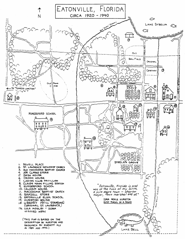
In the late twentieth century, Eatonville was declining, and Orlando's growth was endangering its remaining historic fabric. Everett L. Fly, a Black architect and landscape architect based in San Antonio, Texas, partnered with Eatonville to generate community development guidelines drawing inspiration from Hurston's literary descriptions of the community's character. Furthermore, Fly partnered with Eatonville to launch a Zora Neale Hurston festival. The annual festival extended the visibility of Eatonville's heritage and provided a revenue source to fund future community improvements. In 1988, Eatonville's Historic District was added to the National Register of Historic Places. Eatonville today exists as a town made up of historic pockets intermixed with contemporary development. The town continues to fight for visibility and preservation in the face of Orlando's tourism-driven economic growth.
About the Author
Kofi Boone, FASLA is a professor of landscape architecture at North Carolina State University's College of Design. Boone works at the overlap between landscape architecture and environmental justice with specializations in democratic design, digital media, and interpreting cultural landscapes. He serves on the Board of Directors of the Conservation Network and the Landscape Architecture Foundation.
]]>Video and Essay
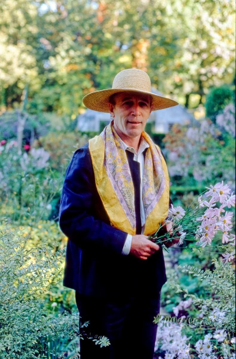
Ryan Gainey (1944–2016) grew up in the Sandhills of South Carolina in the small town of Middendorf, twelve miles north of Hartsville. Born to a working-class family, Gainey picked cotton at an early age with his brothers, sister, and cousins. Through relatives and neighbors, he developed an early love for propagating plants, rooting camellias in Mason jars underneath the eave of a barn (where they could catch the rain), and learning to grow old-fashioned varieties of petunias and roses. In the 1960s, Gainey studied horticulture at Clemson University, served in the Navy, and eventually settled in Atlanta. He opened a series of garden shops in the affluent Buckhead neighborhood that were successful in part because there were few other boutique garden shops in the area at the time. Gainey sourced many of his plants from the Holcombe Nursery in Decatur, five miles east of Atlanta. When he learned that the Holcombe family wanted to sell their property in 1980, he jumped at the chance.
Gainey envisioned a beautiful new garden in the informal cottage style, using the aged brick walls of the old Holcombe greenhouses as the boundaries for a series of "garden rooms." As his creations garnered attention, he received commissions around the city. Although not formally trained in landscape design, Gainey, through self-study and experimentation, developed a distinctive style that combined cottage garden aesthetics and classical English design with a strong reliance on native plants. By the 1990s he'd become internationally renowned, forming friendships with such English gardening notables as Rosemary Verey and Penelope Hobhouse.

Chad Stogner, founder of the garden accessory company Elegant Earth, worked with Gainey in the 1990s and noted that the designer had a way of "making things look spontaneous. . .that were planned." Most gardeners work to eliminate weeds, but Gainey would allow them to pop up in certain areas. To visitors, these would appear as happy accidents, but they were deliberate, as Gainey explained in his 1993 book The Well-Placed Weed from which our documentary takes its title. Gainey's gardens feature a fascinating give-and-take between the structured and the free-flowing.

Gainey chose many of the plants in his garden for their personal and historical connections, such as the chinaberry tree (Melia azedarach), which was a prominent feature in his childhood yard and also was, as he liked to point out, one of Thomas Jefferson's favorite plants. He discouraged gardeners from mimicking the plant choices of classical English gardens and instead championed the use of native southeastern US plants along with plants from similar latitudes in China and Japan.
In March 2016, a 140-year-old white oak tree that had served as the shady anchor of Gainey's Decatur garden fell on his house. At home at the time and miraculously uninjured, Gainey was forced to relocate to Lexington, Georgia, seventeen miles east of Athens where, in July, he died in a fire trying to save his beloved Jack Russell terriers.
We did our first video shoot with Gainey in the spring of 2010. At the outset, we didn't know what we were doing and were content to let him unspool lectures on gardening topics of his choosing: the history of tea olives or figs, blending purple and gold plant colors, and how to maintain fragrance year-round. He thought we were producing a gardening masterclass. None of us thought we were making a documentary.

We became fascinated with the funny moments just before or just after he delivered his monologues—such as when he'd yell at his dogs or tell a dirty joke or make some ridiculous boast. We were drawn to the tangents that floated above and below the persona: his humor, narcissism, and personal connections to plants.
We eventually found structure for the project by developing a series of overlapping threads: Gainey's childhood, his rise as an entrepreneur and social figure in Atlanta, and his wider reputation as garden designer. We were also drawn to his idiosyncratic personality. We witnessed him being prickly and self-absorbed, as well as generous and thoughtful.
There remain gaps in our story. Gainey acknowledged a couple of times on camera that he was gay but never discussed any of his longtime partners in any detail. We tried to steer him to fill in the biographical narrative, but became resigned that there was no directing Ryan Gainey. He served up a vast body of knowledge via his commanding and often contradictory persona. In the end, we did our best to wrangle an honest character study.


We thought we were winding down the project in early 2016 before the tree fell on his house. That event set in motion a string of calamities that culminated in his tragic death. We worked for another year and a half to tidy up the edit and flow before premiering The Well-Placed Weed: The Bountiful Life of Ryan Gainey at a festival in South Carolina in April 2018.
Ryan Gainey made and collected beautiful things. We are grateful that he shared some of these with us and that, through our documentary, we now share this with others.
Visit The Well-Placed Weed's website for more information and to view the documentary in its full length of seventy-eight minutes.
About the Directors
Steve Bransford is the senior video producer at the Emory Center for Digital Scholarship and the founder of Terminus Films. Cooper Sanchez is an artist and garden designer focused on the restoration of historic southern gardens. For ten years, Cooper has been working to rejuvenate the gardens at Historic Oakland Cemetery as well to build his own garden in Clarkston, Georgia.
]]>Review

In the aftermath of the Great Recession, cities and metropolitan regions were often portrayed as (and often were) spaces of economic turmoil and social upheaval. From December 2007 to June 2009, “more than eight million Americans lost their jobs, nearly four million were foreclosed each year, and 2.5 million businesses were shuttered.”1Diane Whitmore Schanzenbach, “The Great Recession: Over but not Gone?” Northwestern Institute for Policy Research, accessed October 23, 2017. http://www.ipr.northwestern.edu/about/news/2014/IPR-research-Great-Recession-unemployment-foreclosures-safety-net-fertility-public-opinion.html. Foreclosures and underwater mortgages decimated real estate markets from Los Angeles to Orlando. Housing starts evaporated. Underfunded and overburdened state governments cracked under the pressure generated by millions of newly unemployed workers, many in cities and suburbs. Businesses contracted or closed and municipal governments faced layoffs and cut programs because of declining tax revenues.
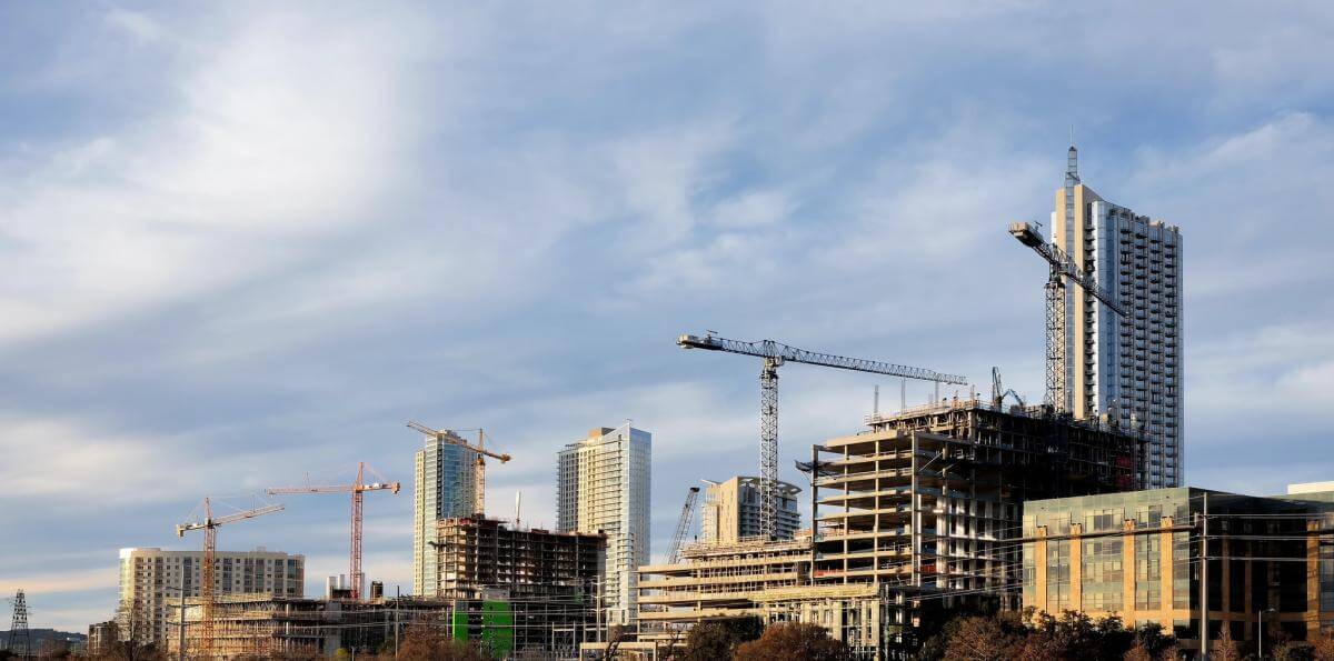
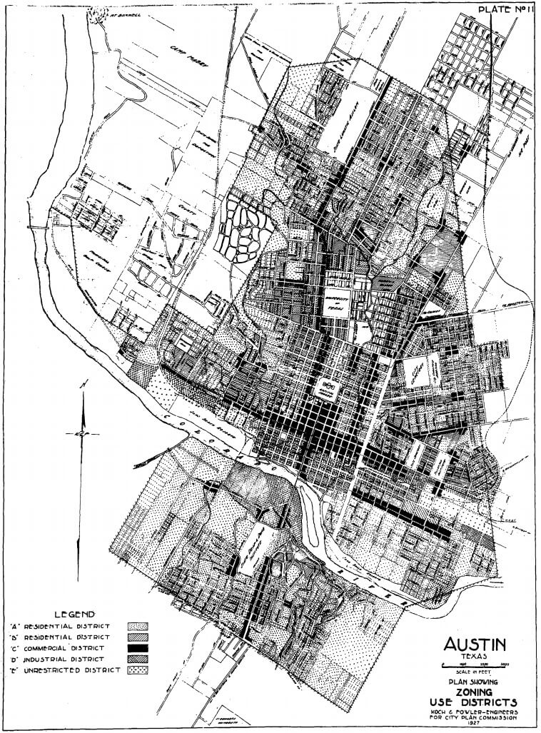
In Austin, Texas, though, growth had rarely been stronger or more dynamic. Its population grew by 30 percent from 2000 to 2013—when it became the fastest growing city in the United States. Popular publications lauded its economic resiliency; Forbes and Time named it the top city for small business and economic growth in 2011. In 2012, Austin experienced a 6.3 percent growth in its economy, easily the best among the 102 largest US markets. The city’s success became a model others sought to emulate. Eliot Tretter, quoting Andrew Park, observes in the opening pages of Shadows of a Sunbelt City that “everywhere you look, cities big and small are trying to get in touch with their inner Austin" (2).
Yet as Tretter forcefully argues, the sunny portrayals of Austin’s economy, cultural vibrancy, creativity, environmental progressivism, and overall quality of life obscure the race and class discrimination below the surface that is closely tied to the city’s history and contemporary landscape. Understanding structural dimensions of this discrimination is paramount to creating cities where resources are shared more equitably. Austin, imagined as a liberal anomaly in a state long defined by conservativism, is quite similar to other more conservative cities throughout the US South in terms of its urban planning, elites’ desire for economic growth and political power, and race relations.2See for example, Joe Feagin, Free Enterprise City: Houston in Political Economic Perspective (Camden, NJ: Rutgers University Press, 1988); Christopher Silver, Twentieth Century Richmond: Planning, Politics, and Race (Knoxville: University of Tennessee Press, 1984); Christopher MacGregor Scribner, Renewing Birmingham: Federal Funding and the Promise of Change, 1929–1979 (Athens: University of Georgia Press, 2002); Kevin M. Kruse, White Flight: Atlanta and the Making of Modern Conservatism (Princeton, NJ: Princeton University Press, 2005); David R. Goldfield, Race, Region, and Cities: Interpreting the Urban South (Baton Rouge: Louisiana State University, 1997).

But Austin stands out in its approach to growth. The uniqueness of Tretter’s argument lies in the local circumstances that elites used to transform Austin from a midsized university and state government town to an emergent global hotspot of technology, sustainability, and cultural production. While the city benefited from a migration of people and capital, its leading sectors of development differentiated it from cities of neighboring states. The University of Texas was key because it generated and fostered a knowledge economy that, combined with the state government, allowed elites to pursue a path for growth that eschewed heavy industry. As national and global priorities began to trumpet high technology in the 1970s and 1980s, Austin was in a prime position to prosper. Tretter explains this process using David Harvey’s “tertiary circuit of capital,” in which “the growing significance of technological and knowledge-rent seeking” increasingly drives economic growth in the developed world (18).3The primary circuit consists of the primary production process (transforming natural resources into finished products, for example) and the secondary circuit consists of investments in infrastructure that facilitates the production process. The tertiary circuit consists of “social infrastructure,” the increased application of science to production to maximize the productive power of labor. Also see David Harvey, The Limits to Capital (London, UK: Verso, 1999). To Tretter, “cities of knowledge such as Austin, and their growth coalitions, strongly supported by federal policy, succeed because they are able to switch capital into the tertiary circuit and expand infrastructure that supports knowledge-rent taking” (19). Research universities, with their wealth of knowledge labor, scientific infrastructure, and public-supported capital, are central to this process, generating private wealth through patenting, technology transfer, and spinoff companies.4For academic capitalism and the role of the university in generating economic growth, see Margaret Pugh O’Mara, Cities of Knowledge: Cold War Science and the Search for the Next Silicon Valley (Princeton, NJ: Princeton University Press, 2005); Roger L. Geiger, Research and Relevant Knowledge: American Research Universities since World War II (New York: Oxford University Press, 1993); Sheila Slaughter and Larry L. Leslie, Academic Capitalism: Politics, Policy, and the Entrepreneurial University (Baltimore, MD: Johns Hopkins University Press, 1997). In his first chapter, “The Making of a Globalized Austin,” Tretter unpacks this technical argument and relates it to broad changes in global capitalism since the 1970s.

Central to Austin’s growth, the University of Texas has acted as the primary force in transforming the city’s urban space, with consequences that reveal a consistent pattern of historical racial discrimination. Tretter examines the role of the university in developing land and shaping geography to facilitate the type of growth desired by political, economic, and university elites—who were often the same people. He gives a broad account of the university’s expansion efforts during the early and mid-twentieth century, emphasizing the conscious effort to improve its research capacity and capture federal research and development dollars in the 1950s. The university used federal urban renewal funds as well as eminent domain laws to enlarge the campus by roughly a hundred acres. The choice to expand into predominantly African American neighborhoods to the east, rather than the white neighborhoods to the north and west, reveals discrimination most clearly. Tretter argues university administrators employed a “racist theory of value,” which assumes “that African American neighborhoods, households, and bodies were simply less valuable and desirable than those of whites” when deciding which neighborhoods to eviscerate (49). Predictably, the outcome was terrible for the already marginalized African American community. Around a thousand people were displaced, dozens of businesses shuttered, and overall racial segregation was intensified as most African Americans resettled in areas further east heavily populated by African Americans. Tretter’s use of University of Texas archival documents is effective here; he demonstrates the racist and often contradictory logic used by University of Texas administrators to justify dispossession of vulnerable residents.
Tretter pursues a similar theme in the 1970s and 1980s, but expands the scope to include the state of Texas as part of the growth machine. Following Harvey and other critics of neoliberalism, Tretter argues that a new era of competitiveness emerged in the 1980s in which universities, as well as cities and states, became more entrepreneurial in attracting investment and generating revenues.5David Harvey, “From Managerialism to Entrepreneurialism: The Transformation in Urban Governance in Late Capitalism,” Geografiska Annaler B 71.1 (1989): 3–17. Texas, looking to diversify its economy, viewed the university as an entity capable of supporting high levels of industrialization because of its research and development capacity. Federal and state liberalization of patent and technology laws incentivized this “academic capitalism” by making it possible for both researchers and universities to profit from high tech patents and licensing. Universities became more profit-oriented. In an original and important argument, Tretter emphasizes how universities, with their quasi-public status, were also lucrative assets because of their ability to develop land that could provide incentives for outside investment. This strategy paid off when the state, city, and university partnered to attract two major research consortia, Microelectronic and Computer Corporation in 1983 and SEMATECH in 1987, largely by offering university assets: space, labor, capital, and land. Along with other branch facilities and a growing sector related to the defense industry, high tech formed the core of Austin’s growth in the 1980s and established the city as an important technological hub and emergent global city.
“Urban Transformations,” the second half of Shadows of a Sunbelt City, emphasizes the role of urban planning (particularly Smart Growth and urban sustainability) and its relationship to municipal governance in contemporary Austin. Why did sustainable planning emerge so forcefully here? How did it affect vulnerable residents, homeless people and minorities? Tretter chronicles how sustainability and environmental quality became central to Austin’s growth in the 1990s. After decades of bitter confrontation, the city’s pro-development and anti-development coalitions struck a deal where the city’s pristine western hinterland, long the concern of environmentalists, would be protected from intensive development. In return, environmentalists supported bonds and zoning changes that incentivized development in Austin’s urban core, effectively transferring the city’s geography of development from suburban to urban. The city council adopted Smart Growth policies, which encouraged higher density, environmental protections, and other New Urbanist ideals. These changes, Tretter argues, increased Austin’s competitiveness but necessitated increased policing of the homeless who were seen as impediments to the livability of downtown. Austin’s growth advocates came to understand environmental amenities and quality of life as marketable features that could further their interests.6John R. Logan and Harvey L. Molotch, Urban Fortunes: The Political Economy of Place (Berkeley: University of California Press, 1987).
Tretter assesses the outcomes of sustainability on Austin’s populations of color, concentrating on the chasm between mainstream environmentalists and the Latino environmental justice group People Organized in Defense of Earth and her Resources (PODER). He concludes that minorities bore the burden of sustainability because the growth coalition saw their neighborhoods as potentially lucrative to redevelop but also because PODER couldn’t convince mainstream environmentalists that minority displacement was an environmental concern. Improvement in the lives of vulnerable minorities, writes Tretter, will only be possible through an inclusive redefinition of the “environment.”
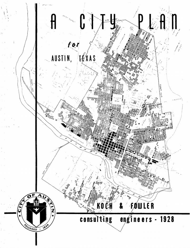
Examining the historical relationship between urban governance and urban planning in Austin, Tretter charts the major changes in the structure of the city’s government (from a ward system to a commission to a city manager system from 1900 to 1924, and the adoption of at-large voting) and correlates them with large-scale urban planning initiatives (e.g., the 1928 Austin City Plan). He follows this line of inquiry through to the present, with business elites still the leading actors in urban planning.
Supported by much research—interviews, archival materials, and interdisciplinary secondary source material—Shadows of a Sunbelt City is effective in its theoretical intervention (though as a geographer, Tretter’s major conversations also engage that field). Emphasizing the university as land developer is the book’s most important contribution to urban studies; this aspect has long been overlooked in favor of research universities’ knowledge production and patenting, production of skilled labor, and ability to generate private firms. Tretter complicates our understanding of the relationship among sustainability, growth, and uneven social and spatial relations. Numerous maps and graphs enhance his arguments. Tretter’s engagement with David Harvey and the tradition of materialist geography demonstrates a commitment to principles of justice, as does his concern with uneven power relations and the myriad ways that growth paradigms undermine the rights and autonomy of vulnerable populations. Shadows of a Sunbelt City is a theoretically sophisticated and critically thoughtful book that improves our understanding of the knowledge economy, sustainable urban practice, racial discrimination, and urban governance and power.
A more developed introduction could have identified a stronger central theme tying the book together. But to his credit, Tretter points out that Shadows of a Sunbelt City is “not written to reflect a straightforward historical narrative,” and offers multiple reasons why Austin is important to study (5). Each chapter intervenes in different discussions and contains several claims. Tretter’s chapter that follows changes in urban governance throughout the entire twentieth century, while richly detailed and convincing, could have been more strongly connected to the rest of the book.
Although the “Sunbelt” of the book’s title is offered as a unifying concept, it is neither defined nor explained, nor does Tretter does contextualize Austin in relation to other “Sunbelt” writing. Tellingly, the term does not appear in the index. This is a glaring omission given the long-standing arguments over what constitutes the Sunbelt. Neither is “Environment,” also in the title, analyzed in the manner readers might expect. Tretter offers an insightful analysis of how the environmental movement and environmental politics unfolded in Austin, but very little about how the natural world was augmented as Austin grew. As urban environmental studies are documenting, environmental improvements, policies, and ideology are often active components in the oppression of minorities during urbanization.
Shadows of a Sunbelt City offers a compelling analysis of the power that universities wield in regional development and their complicity in reshaping the urban form to benefit powerful actors, often at the expense of vulnerable residents. As he examines how policy and social relations transform cities, Tretter challenges the narrative that sustainable urban policy, and the knowledge economy that undergirds it, is universally beneficial.
About the Author
Andrew M. Busch is an assistant professor in the Honors Program at Coastal Carolina University where he teaches interdisciplinary courses on urbanism, environmental studies, globalization, and US History. His first book, City in a Garden: Environmental Transformations and Racial Justice in Twentieth-Century Austin, Texas was published by the University of North Carolina Press in 2017.
]]>Introduction

In August 2015, the Collier Heights home of Herman J. Russell (1930–2014), African American construction and real estate executive, came on the Atlanta market for $675,000. The listing video characterizes Russell's home as a hub for both real estate transactions, political strategy sessions, and community barbecues.1After two price reductions, as of January 2016, the house was listed at $497,000. See Phil W. Hudson, "Herman J. Russell's home hits the market," Atlanta Business Chronicle, January 8, 2016, http://www.bizjournals.com/atlanta/news/2016/01/08/herman-j-russell-s-old-home-hits-the-market.html; Kimberly Turner,"House Envy: Andrew Young reminisces on Herman J. Russell's 1963 Home," Atlanta Magazine, January 20, 2016, http://www.atlantamagazine.com/homeandgarden/house-envy-andrew-young-reminisces-on-herman-j-russell-1963-home/. The founder of H.J. Russell & Co. was a key player in the city's racially-shifting midcentury real estate business and power structure. Collier Heights, originally a predominately white neighborhood in Atlanta’s southwest corner, would not have welcomed Russell when he founded his company at the height of Jim Crow restrictions in 1952. The 8,761-square-foot residence on 714 Shorter Terrace signals the hard work and commitment of businessmen and women, like Russell, who established residential and retail districts for Atlanta’s growing black middle class. In 2009, the National Register of Historic Places recognized Collier Heights as the first neighborhood developed, financed, designed, and constructed by African Americans for African American residents.2See Betsy Riley, "Collier Heights awarded Local Historic district status," Atlanta Magazine, May 16, 2013, http://www.atlantamagazine.com/civilrights/collier-heights-awarded-local-historic-district-status/; U.S. Department of the Interior, National Park Service, National Register of Historic Places Registration Form: Collier Heights Historic District Application, NPS Form 10-900,OMB No. 1024-0018, received by NPS May 15, 2009, http://www.nps.gov/nr/publications/sample_nominations/CollierHeightsHD.pdf.

As of 2016, Collier Heights is a neighborhood of approximately 1,700 single-family homes in 54 separate but interrelated subdivisions on over one thousand acres. Fleeing urban displacement, impoverished schools, and rampant segregation, African American residents moved to Collier Heights en masse between 1952 and the late 1960’s, redefining the area’s color line and populating a neighborhood important in the civil rights movement. Former residents include Martin Luther King Sr., Christine King Farris, and Ralph David and Juanita Abernathy.
Lydia Harris: Photographer's Statement

In 2010, I began taking portraits of homeowners in front of their Collier Heights houses using my 4x5 large format camera. After spending two years meeting with residents and making images of facades, I began conducting oral history interviews and taking photos inside neighborhood homes. These sessions became the 2015 book and photo exhibition, "The View of Collier Heights," staged in the Auburn Avenue Research Library Auxillary Gallery at Atlanta’s Hammonds House Museum.
For this Southern Spaces photo essay, I include "Facades," photos of the homeowners ("Faces"), along with several interiors ("Recreation Rooms" and "A Seat at the Counter") of Collier Heights homes. During Jim Crow, when owning a home was a civil rights victory unto itself, neighborhood residents made full use of their hard-won residences. These photographs suggest how facades and recreation rooms (with furniture, home design, objects, and décor) expressed one style of African American domestic life in midcentury Atlanta.
Facades

The home of Mr. Alfred and Dorothy Knox in the Royal Oaks Manor subdivision of Collier Heights, October 14, 2012. "This was a kind of remote area of the city when we first moved here," Knox, a businessman explains. "We were displaced by urban renewal. And although I kind of objected to being displaced, because I had a business there, and I had great plans for improvement in the community, south of the city here, but we lost all and moved here. And we are very glad that we moved here. Very pleasantly surprised to have such good neighbors." Knox, interview by author, May 13, 2013.

The home of Mr. Roger Mathews located in the Valhacha subdivision of Collier Heights, November 9, 2011.

The home of Mr. Charles and Dr. Lois Moreland in the Royal Oaks Manor subdivision of Collier Heights, October 12, 2013. The Morelands moved into their home in December of 1961.

The home of Dr. William B. Shropshire III and Dr. Marian Shropshire on Waterford Road in the Woodlawn Heights area of Collier Heights, November 14, 2011.

The home of native Atlantan Dr. Harvey B. Smith, who lives next door to the Shropshires, January 9, 2013. Smith was one of the original land buyers in the Woodlawn Heights Development Company, which built and developed significant portions of Collier Heights. He came to this neighborhood because there was a "great need for housing for people within my group, and there were few places you could find to go." Smith, interview by author, January 11, 2013.


The home of Alma and Albert Hayward in the Woodlawn Heights subdivision of Collier Heights. Top, under construction in 1962, and bottom, May 17, 2015. Historic image courtesy of the Haywards.
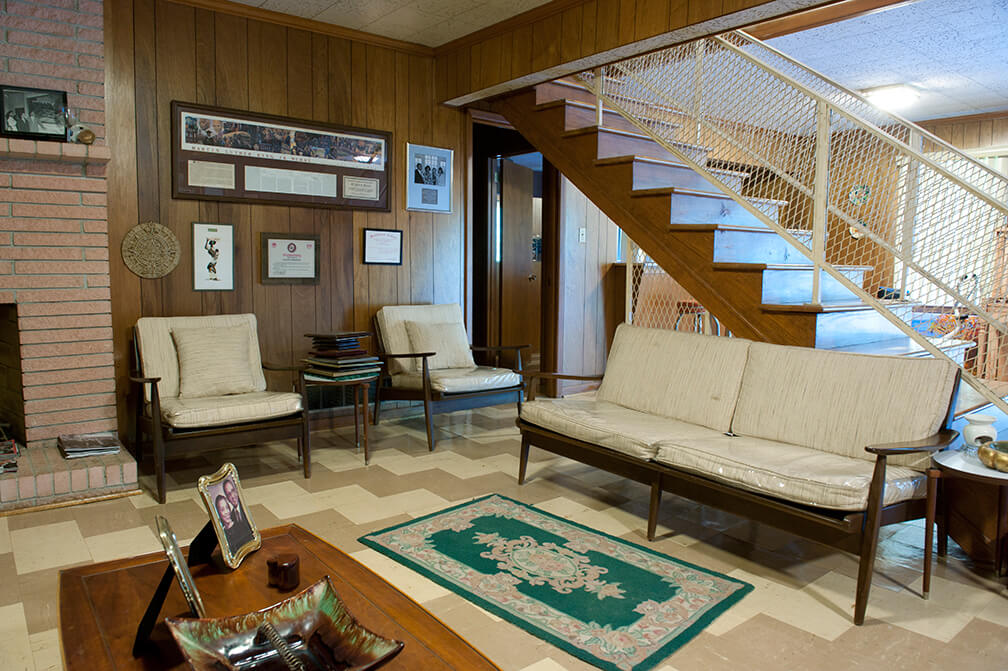
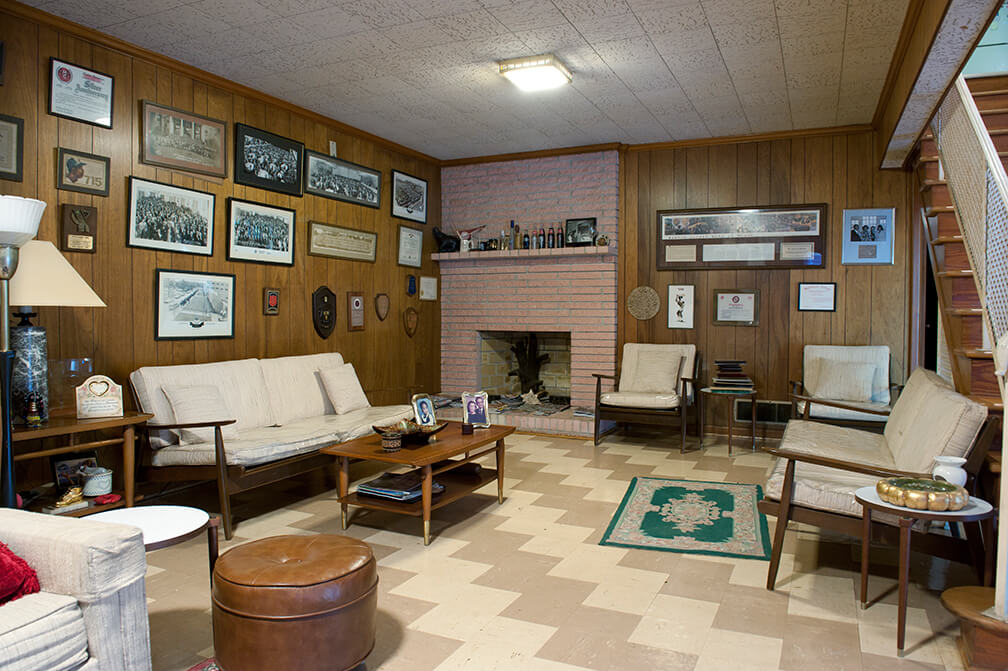
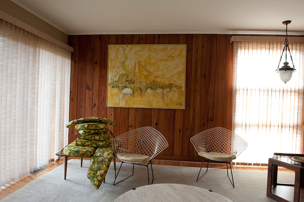
Recreation Rooms
Of the thirty-nine homes that existed in Royal Oaks Manor (a Collier Heights subdivision) in 1969, twenty-two included recreation rooms intended for "seated luncheons, dances, parties, receptions, fashion shows, games, relaxation, and television."3A considerable percentage of space was dedicated to leisure time, unlike the small houses in the original Collier Heights subdivisions that were built for middle class Americans. See Annie S. Barnes, The Black Middle Class Family: A Study of Black Subsociety, Neighborhood, and Home in Interaction (Lima, Ohio: Wyndham Hall Press, 1985), 74. Henry Herbert Bankston, a government worker and resident of Collier Heights, remembers, "I think about our getting together like we once did and it was basically because we did entertain in our basement. Or in our recreation area, that's what we called it. And that's where we had our parties, that’s where we had dances, and all, and meetings, in our basements. See, we can come in here and entertain in this living room, but that recreation room downstairs is where we came and had our little dances, where we had our club meetings, and so forth and so on. Most of these homes around here are equipped that way."4Henry Herbert Bankston, interview by author, April 12, 2012.

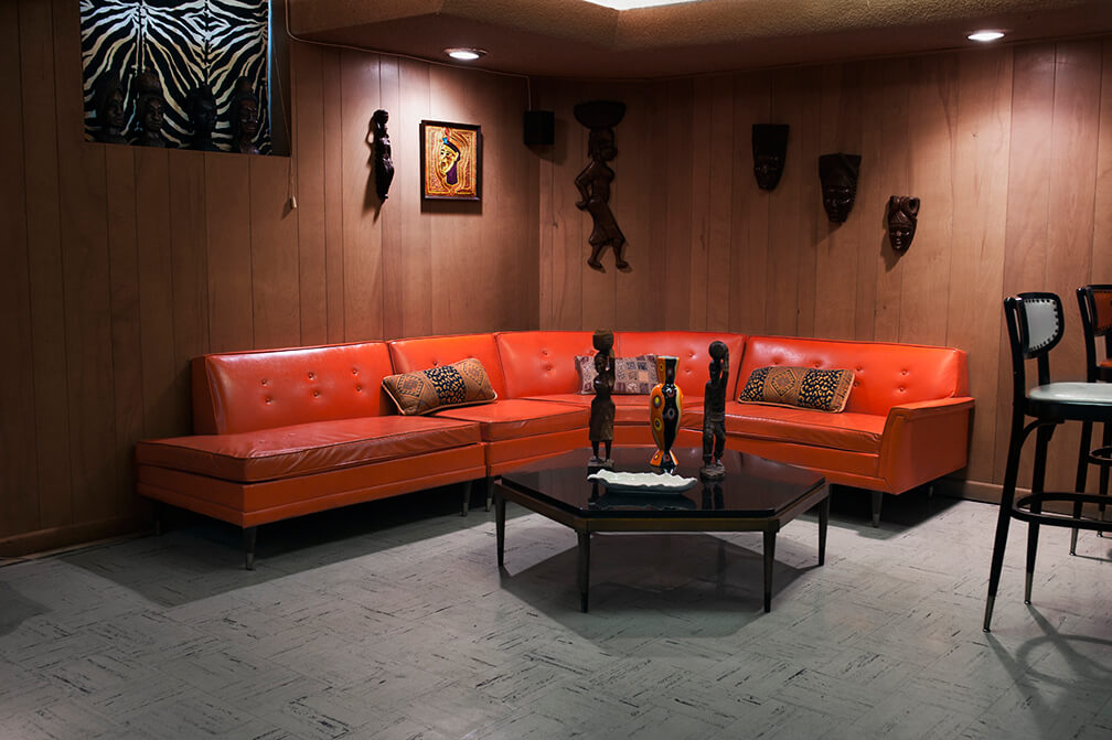


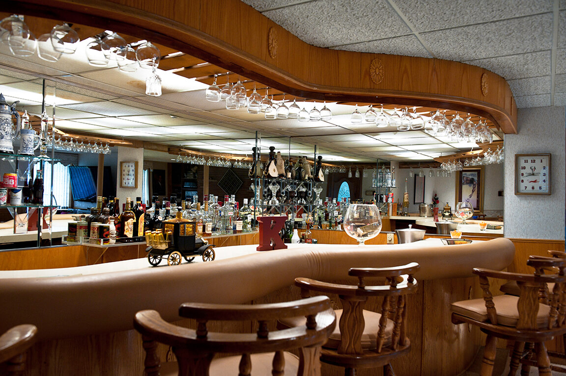
A Seat at the Counter


Faces

Alfred and Dorothy Knox, October 14, 2012.

Charles and Dr. Lois Moreland, October 12, 2013.

Dr. William B. Shropshire III and Dr. Marian Shropshire, November 14, 2011.

Dr. Harvey B. Smith, January 9, 2013.

Alma and Albert Hayward, May 17, 2015.

Constance Pruitt and her son John, April 6, 2012.

E. Gayle Barnett, January 10, 2013.
Brick by Brick
As Lorainne Hansberry writes in 1959’s A Raisin in the Sun, "we have decided to move into our house because my father—my father—he earned it for us brick by brick."5Lorraine Hansberry, A Raisin in the Sun (New York: Vintage Books, 1994), 148. For residents whose homes were built—brick-by-brick—by fellow African Americans, from conception to financing to development and construction, Collier Heights represents more than a hallmark of change. The neighborhood became a sanctuary where black Atlantans claimed a space of their own. As I return to the image of the Herman J. Russell home that begins this essay, my eye follows a stone path to the front door. As neighborhoods like Collier Heights experience new demographic shifts and historic homes go on the market, may we remember those who opened doors and paved the way.
About the Artist
Working in photography, video, and installation, Lydia A. Harris's art tackles situations of inequality and power dynamics. Her solo shows have included exhibitions at the Photographic Resource Center in Boston, the Hammonds House Museum/Auburn Avenue Research Library Auxiliary Gallery in Atlanta, and the Firehouse Center for the Arts in Newburyport, Massachusetts. Group shows have included exhibitions at the Fort Point Art Center, the Essex Art Center, the Griffin Center for Photography, the Museum of Fine Art Boston, The Light Factory’s 4th Juried Annuale in Charlotte, North Carolina, and the University of Maine Museum of Art Photo National 2011 where she received the director’s purchase award for "Hendrie." For more information, please visit the artist's website.
]]>Review
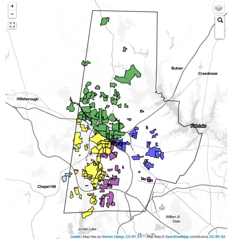
Sarah Mayorga-Gallo's Behind the White Picket Fence explores how race, class, and ethnicity shape daily life and power sharing in "Creekridge Park," a pseudonymous multiethnic neighborhood located in Durham, North Carolina. In the early twentieth century, the neighborhood was predominantly white working- and middle class, but as the housing stock aged in the late 1980s, more African American families gained access. Creekridge Park also experienced an influx of Latino immigrants after 2000, as the overall Latino population of Durham grew rapidly. With a mix of single-family homes and apartment complexes built during different periods, the neighborhood was home to 1,570 people in 2010, among whom 34 percent were non-Hispanic white, 39 percent were black, and 26 percent were Hispanic. At that time, 66 percent of residents were renters.
Given the demographics, one might suppose that Creekridge Park represents a well-integrated racial and ethnic neighborhood. However, drawing on interviews, surveys, and participant observation, Mayorga-Gallo, an assistant professor of sociology at the University of Cincinnati, argues against the "tyranny of proportionality," or the over-reliance on statistical measures of neighborhood diversity and integration (6). Nominal integration does not equate with power and resource sharing, equal status, or reciprocity in relationships; rather, closer examination of the everyday interactions among residents reveals how seemingly benign and race-neutral practices perpetuate inequality.
A central theme of Behind the White Picket Fence is that middle-class whites utilize many resources to maintain power while simultaneously extolling the virtues of their multiethnic environment. Deploying what Mayorga-Gallo terms a "diversity ideology," whites extol the neighborhood's funky charm and eclectic mix of housing and population (race, ethnicity, class, sexual orientation, and family type), and yet maintain mostly homogeneous friendships and make little effort to include or address the needs of minority residents (23, 55–57). Mayorga-Gallo likens diversity ideology to colorblind racism,1Eduardo Bonilla-Silva, Racism without Racists: Color Blind Racism and the Persistence of Racial Inequality in America (Lanham, MD: Rowman & Littlefield Publishers, 2013). a concept predicated on the notion that intentions, not outcomes, are what matter: valuing diversity is considered enough, even if behaviors, structures, and institutions reproduce inequality. This ideology allows white residents to celebrate progressiveness while failing to promote meaningful inclusion.

Creekridge Park Demographics. Map by George Mayorga. From Behind the White Picket Fence: Power and Privilege in a Multiethnic Neighborhood by Sarah Mayorga-Gallo. Copyright © 2014 by the University of North Carolina Press. Used by permission of the publisher. www.uncpress.unc.edu.
According to Mayorga-Gallo, Creekridge Park's local neighborhood association illustrates this dynamic. Its membership, comprised almost exclusively of white homeowners, is far from demographically representative of the neighborhood. Rather than understanding the lack of minority representation as undermining their legitimacy, association members rationalize it as the tendency for minority residents to be renters and less invested in the neighborhood. By emphasizing the universality and neutrality of the organization, and insisting that they work to better the neighborhood for all residents, board members excuse themselves from considering the fundamental importance of inclusion. Mayorga-Gallo illustrates how the association's promotional practices are a key source of minority underrepresentation. The quarterly neighborhood newsletter is distributed door-to-door for single-family homes, but not to apartments; events are announced via an email listserv and are seldom advertised in Spanish. Such practices tend to exclude renters and residents of color. Aware of these limitations, and occasionally voicing the need for correction, board members take no action; instead, they create an all-white space that discourages broader participation.
Mayorga-Gallo also argues that white homeowners, many of whom are recent additions to the neighborhood, not only assume they are entitled to mandate local norms but, because of race and class power, actively do so. The resulting "white codes" dictate appropriate behavior, producing mostly mono-racial social networks and maintaining a high degree of social distance despite physical proximity (59, 92–93). Accordingly, white owners opposed higher density additions and pursued more stringent construction standards as part of a greening initiative; meddled in how their neighbors treated their dogs; entered others' yards to pick up trash; set the terms for participating in the community garden; and were often patronizing to lower-class neighbors. They pursued neighborhood watch programs, cultivated a close relationship with the police, and were quick to resort to formal methods of addressing complaints (particularly by calling the police), rather than privileging face-to-face interactions with neighbors.
These seemingly non-racial practices produce highly racialized outcomes. For African Americans, living in Creekridge Park brings material benefits at the cost of social isolation and everyday insensitivities. Gentrifying upgrades to commercial spaces alienate low-income blacks. Mayorga-Gallo's findings suggest that Latino residents are often more quiescent, attributing their lack of interaction with neighbors to language barriers, rather than to social exclusion. However, their second-class status is reinforced when they participate in neighborhood events.
Behind the White Picket Fence ends with a call to action. Mayorga-Gallo argues that statistical integration should not be an ultimate goal for researchers or policy makers. The relationship between proximity and equity is not fixed. Instead, diversity can reinforce white privilege just as easily as it can promote equity and justice. She urges us to reframe the conversation about racial inequality from one about good and bad individuals to one about power, privilege, and outcomes. It is not enough to say that everyone is welcome at neighborhood meetings; Mayorga-Gallo calls for active minority recruitment and inclusion, balancing the interests of homeowners against those of renters.
Mayorga-Gallo's multifaceted insights contribute importantly to the topics of colorblind racism and urban ethnography—which rarely examines non-poor neighborhoods or those outside of central cities. Understanding white middle-class practices of exclusion is essential to understanding residential segregation and urban poverty. Moreover, Behind the White Picket Fence features a diversity of voices. Mayorga-Gallo interviewed long-time residents and newcomers, moved beyond the black-white binary to include Latinos, and spoke with owners and renters.
. Photograph by Flickr user bullcitydave, May 15, 2008. Courtesy of bullcitydave. CC BY-NC-ND 2.0.")
Future work could build on Mayorga-Gallo's analysis to link her findings with larger institutional contexts. Even if proximity does not foster diverse friendships or inclusion in neighborhood associations, it can promote meaningful social change if it boosts the tax base and contributes to school desegregation. Durham often loses middle-class residents to Chapel Hill or to other parts of the metro region with lower percentages of racial and class-based diversity. Desegregating residential neighborhoods is central to the goal of educational integration, which has suffered setbacks in recent years. There is intense and growing interest in how families weigh the characteristics of homes, neighborhoods, and schools when deciding where to live.2Annette Lareau and Kimberly Goyette, eds., Choosing Homes, Choosing Schools (New York: Russell Sage Foundation, 2014). Mayorga-Gallo observes that few Creekridge whites send their children to the local elementary school, which is predominantly minority, opting instead for charter or private schools. A sustained critique of the ways diversity ideology plays out would be a valuable extension of Behind the White Picket Fence, delving into the processes by which white parents rationalize valuing diversity on the block but not, for example, in the classroom.
About the Author
Chenoa Flippen is associate professor of sociology at the University of Pennsylvania. She completed her Ph.D. in sociology at the University of Chicago. Her research addresses the connection between racial and ethnic inequality and contextual forces at the neighborhood, metropolitan, and national levels.
]]>Greetings from Austin
.")
In July of 2011 Bon Appétit named Franklin Barbecue of Austin, Texas, the best barbecue restaurant in America. As one of the flagship businesses in an area of the city undergoing significant redevelopment Franklin (which began as a food truck three years earlier) had recently moved into a building on East Eleventh Street, adjacent to downtown across Interstate 35. Franklin Barbecue helped enhance the city's wider reputation while locally it helped the reputation of the central Eastside. The white-owned Franklin took the former space of Ben's Long Branch Barbecue, an African American–owned business operating since the 1980s; African Americans had served barbecue at this site since at least the early 1960s. The corridor, formerly the hub of black commerce and social life during the era of segregation, fell into blight and disrepair in the 1970s and sunk into deeper trouble by the 1980s as residents of means and local businesses fled. In the 1990s the Austin Revitalization Authority (ARA) was formed as a non-profit to assist in the commercial development of the neglected neighborhood as well as to renew historic buildings and homes to maintain architecture consistent with the area's heritage. In 1997 the ARA declared the area a slum, making it eligible for Section 108 Community Development Block Grants (CDBG) from the US Department of Housing and Urban Development (HUD).1Much of the early history of the ARA was marred by questionable real estate practices and stacking of the ARA board by councilman Eric Mitchell and his group of connected developers and politicians. Mitchell did not include any neighborhood representatives on the first ARA board. See A. D., "ARA Board Member Helps Himself," Austin Chronicle, January 12, 1996, http://www.austinchronicle.com/news/1996-01-12/530368/; Mike Clark-Madison, "The ARA Myth: Empty Promises on the Eastside," Austin Chronicle, June 20, 1997, http://www.austinchronicle.com/news/1997-06-20/529133/. After completing the Central East Austin Master Plan, which called for 140,000 square feet of mixed-use development, the ARA and the city acquired over $9 million in CDBGs to initiate revitalization. Almost all development took place along the Eleventh Street corridor.2Crone Urban Design Team, "New Visions of East Austin: Central East Austin Master Plan," Report, 1999, courtesy AHC.
Although development in the East Eleventh Street corridor began slowly, by the mid-2000s the area's importance to the city's Eastside efforts and to the downtown was apparent. Eleventh Street is one of only two downtown streets that bridge I-35, the physical barrier between minority and Anglo neighborhoods since its completion in 1962. People coming from downtown to East Eleventh do not have to pass underneath the highway. Signs displaying the East End slogan "Local Spoken Here" invite consumption along the corridor. A gateway arch laden with the Texas Star welcomes traffic from downtown. The cityscape here appears more modern, newer, and cleaner than much on the Eastside. Multiple use zoning allows for architecture consistent with New Urbanism: higher density, mixed use, better public transport and bike lanes, historic districts, and heritage-based public spaces. The area has undergone significant demographic change as middle class whites and upscale businesses have moved in.3Ryan Robinson, "Top Ten Demographic Trends in Austin, Texas," http://www.austintexas.gov/page/top-ten-demographic-trends-austin-texas, accessed December 18, 2014. Robinson is the city's demographer.
New Urbanism became the architecture of gentrification and redevelopment in Austin.4For theories of New Urbanism, see Peter Katz, The New Urbanism: Towards an Architecture of Community (New York: McGraw-Hill, 1994); Congress for the New Urbanism, Charter of the New Urbanism (New York: McGraw-Hill, 2000); Andres Duany, Jeff Speck, with Mike Lydon, The Smart Growth Manual (New York: McGraw-Hill, 2010); Andres Duany, Suburban Nation: The Rise of Sprawl and the Decline of the American Dream (New York: North Point Press, 2001). Since the late 1990s, two trends are evident. First, there is new interest in urban space, lifestyles, and consumption preferences in a city long defined by suburbanism. Second, municipal leaders and real estate developers recognized the potential for significant increases in exchange values—and property taxes—by refurbishing parts of the neglected urban core. Since the 1980s, many US cities have become more entrepreneurial in attracting investment and stimulating development in areas deemed undervalued.5David Harvey, "From Managerialism to Entrepreneurialism: The Transformation of Urban Governance in Late Capitalism," Geografiska Annaler 71. no. 1, Series B (1989): 3–17; Jason Hackworth, The Neoliberal City (Ithaca: Cornell University Press, 2007); Gerald Dumenvil and Dominique Levy, Capital Resurgent: Roots of Neoliberal Revolution, trans. Derek Jeffers (Cambridge: Harvard University Press, 2004). In Austin, gentrification and rising rents have forced displacement in neighborhoods that for decades housed the city's highest concentrations of African American and Latino residents.
The most deleterious outcome of gentrification is its effect on existing social cohesion, which is much more important for vulnerable and historically segregated neighborhoods of color where residents have fewer relocation options and are more dependent on the neighborhood for social structure than are residents of middle class neighborhoods.6John Betancur, "Gentrification and Community Fabric in Chicago," Urban Studies 48, no. 2 (2011): 383–406; Mark Davidson, "Spoiled Mixture: Where does State-led 'Positive' Gentrification End?," Urban Studies 45, no. 12 (2008): 2385–2405; Neil Smith, The New Urban Frontier: Gentrification and the Revanchist City (London: Routledge, 1996). Poorer minorities are more vulnerable to rent hikes and increased costs and are more dependent on place for community than wealthier groups. They also tend to understand community in terms of place, especially in historically segregated locations.7John R. Logan and Harvey Molotch, "Homes: Exchange and Sentiment in the Neighborhood," in Urban Fortunes: The Political Economy of Place (Berkeley: University of California Press, 1987): 99–146; David Harvey, "Flexible Accumulation through Urbanization: Reflections on 'Post-Modernism' in the American City," in Post-Fordism: A Reader (Oxford: Blackwell, 1995): 361–386; Cynthia Horan, "Community Development, Racial Empowerment, and Politics," Annals of the American Academy of Political and Social Science 594 (2004): 158–170. Although gentrification is in some sense a function of market changes, political and economic disparities in the allocation of municipal capital undergird the relationship between gentrification and spatial justice in Austin. While the city uses public money to attract investment, subsidize more expensive development in East Austin, and generate tax revenue, it does not adequately invest to provide subsidies for affordable housing for long-term and disadvantaged neighborhood residents, many of whom have been forced out of Central East Austin or have lost friends and family to displacement.
.")
.")
The Austin example augments existing research on gentrification which seeks either to explain and critique the process or tell stories of change from residents' perspectives.8Important recent on gentrification process include Jason Hackworth and Neil Smith, "The Changing State of Gentrification," Journal of Economic and Social Geography 92, no. 4 (2001): 464–477; Rowland Atkinson and Gary Bridge, eds., Gentrification in a Global Context: The New Urban Colonialism (New York: Routledge, 2005); Loretta Lees, "Gentrification and Social Mixing: Towards an Inclusive Urban Renaissance?" Urban Studies 45, no. 12 (2008): 2449–2470. Studies emphasizing residents' perceptions include Japonica Brown-Saracino, A Neighborhood that Never Changes: Gentrification, Social Preservation, and the Search for Authenticity (Chicago: University of Chicago Press, 2009); Lance Freeman, There goes the 'Hood: Views of Gentrification from the Ground Up (Philadelphia: Temple University Press, 2006). The literature on gentrification in Austin links the city's emphasis on environmental sustainability as a competitive advantage to externalities that displace vulnerable groups and generate or exacerbate socioeconomic inequality.9Eliot M. Tretter, "Contesting Sustainability: 'SMART Growth' and the Redevelopment of Austin's Eastside," International Journal of Urban and Regional Research 37, no. 1 (January 2013): 297–310; Joshua Long, "Constructing the Narrative of the Sustainability Fix: Sustainability, Social Justice, and Representation in Austin, Texas," Urban Studies (December 2014): 1–24; Eugene J. McCann, "Inequality and Politics in the Creative City-Region: Questions of Livability and State Strategy," International Journal of Urban and Regional Research 31, no. 1 (March 2007): 188–196; Elizabeth J. Mueller and Sarah Dooling, "Sustainability and Vulnerability: Integrating Equity into Plans for Central City Redevelopment," Journal of Urbanism: International Research on Placemaking and Urban Sustainability 4, no. 3 (2011): 201–222; Emily Skop, "Austin: A City Divided," in The African Diaspora in the United States and Canada at the Dawn of the 21st Century, ed. John Frasier, Joe T. Darden, and Norah F. Henry (New York: Academic Publishing, 2009); Eric Tang and Chunhui Ren, Outlier: The Case of Austin's Declining African American Population (Austin: University of Texas Institute for Urban Policy Research and Analysis, 2014). Austin's experience also calls into question several recent studies which argue that gentrification has fewer negative outcomes on poor or minority neighborhoods than previously assumed.10Ingrid G. Ellen and Katherine M. O'Regan, "Gentrification and Low Income Neighborhoods: Entry, Exit, and Enhancement," Regional Science and Urban Economics 41, no. 2 (March 2011): 89–97; Jacob P. Vigdor, "Is Urban Decay Bad? Is Urban Revitalization Bad Too?" Journal of Urban Economics 68, no. 3 (2010): 277–289; J. Peter Byrne, "Two Cheers for Gentrification," Howard Law Journal 46, no. 3 (2003): 405–432. In this article, my approach draws from traditional perspectives: the production side, which understands gentrification as part of the larger forces of capital that transform and restructure urban physical landscapes11Foundational works on production side gentrification include Neil Smith, "Towards a Theory of Gentrification: A Back to the City Movement by Capital, not People," Journal of the American Planning Association 45, no. 4 (October 1979): 538–548; "Gentrification and Uneven Development," Economic Geography 58, no. 2 (April, 1982): 139–155; and The New Urban Frontier: Gentrification and the Revanchist City (New York: Routledge, 1996).; and the consumption side, that views consumer preference as the driving force.12David Ley, "Alternative Explanations for Inner-City Gentrification: A Canadian Assessment," Annals of the Association of American Geographers 76, no. 4 (December, 1986): 521–535; and The New Middle Class and the Remaking of the Central City (Oxford: Oxford University Press, 1996). Middle class consumers, developers, and planners view New Urbanism as environmentally-friendly architecture that reflects sustainable urban lifestyles. Longtime residents, most of whom are minorities and many of whom are economically disadvantaged, regard New Urbanism as producing new urban spaces that undermine the sustainability of their neighborhoods. While the former group focuses on how the built landscape enhances sustainability by lessening pollution and energy use and moving development away from pristine natural areas, the latter group seeks to explain gentrification’s deleterious socioeconomic effects on vulnerable populations.
Studying locally or regionally specific aspects of gentrification uncovers correlations between spatial reorganization, urban political economy, and historical experience. Two circumstances particular to Austin are important. Compared to most US cities, Austin historically had a much less fluid racial geography: de facto segregation was more intense and less driven by exchange values in the era before gentrification began. Furthermore, gentrification in Austin was initiated in the 1990s by the municipal government as a response to increased regulation of development on the city's western periphery, formerly a main area of growth, at the behest of the city's environmental movement. In 2000, Central East Austin had a poverty rate over 45 percent and over 95 percent of residents were black or Latino.13Elizabeth Sobel, "Austin, Texas: The East Austin Neighborhood" (Report of the Federal Reserve Bank of Dallas, 2007).
New Urbanism plays a symbolic role in neighborhood change with some of its proponents viewing gentrification uncritically or positively. Long-term residents of the central Eastside often linked New Urbanism's architecture and zoning changes with potential gentrification, requiring neighborhood groups to act defensively rather than as agents of positive social change. Once gentrification began, the already meager neighborhood resources available increasingly went to defend against demographic change and upscale development. New Urbanism can mean one thing for Austin residents who are likely to be displaced as property values and taxes rise, but something else for Austin's middle class residents and consumers.14Andres Duany, one of the principle architects of New Urbanism and perhaps its most famous proponent, celebrates gentrification. See Duany, "Three Cheers for Gentrification!: It Helps Revive Cities and Doesn't Hurt the Poor," American Enterprise (April 2001): 38–39; Martin Boddy, "Designer Neighborhoods: New Built Residential Development in Non-Metropolitan UK Cities—the Case of Bristol," Environment and Planning A 39, no. 1 (January 2007): 86–105.
Beginning with a discussion of the East Eleventh Street corridor as it exists today, this essay moves into a brief history of racial geography in Austin before addressing the political and economic factors that drove investment. Engaging with architectural theory, a subsequent section examines how New Urbanism and historical preservation altered the cityscape. Following Tom Slater's call to study working class displacement and resistance to gentrification, the essay concludes by asking how Austin residents and neighborhood groups approached gentrification, its symbols and causes, and its relationship to political and economic drivers of urban transformation.15Tom Slater, "A Literal Necessity to be Replaced: A Rejoinder to the Gentrification Debates," International Journal of Urban and Regional Research 32, no. 1 (March 2008): 212–223; and "The Eviction of Critical Perspectives from Gentrification Research," International Journal of Urban and Regional Research 30, no. 4 (December 2006): 737–757.
New Urbanism and the Symbolic Economy on East Eleventh Street
.")

Pragmatically, producing urban space depends on the deployment of capital and labor. But city building also requires symbols and signs indicating who is accepted in a place and who is not, what should be visible and what should not. Developers used New Urbanism on Eleventh Street and along the Eastside to signal middle class consumption space. Producing a sense of local history and diversity was also important to the Austin Revitalization Authority's effort. The city lowered taxes for the redevelopment of historical structures. The earliest projects redeveloped buildings such as two structures dating from the late nineteenth century, the Haenhel Building and the Arnold Bakery, which were refurbished and rented to businesses. The next projects were larger live-and-work facilities featuring retail on the ground floor with living spaces above and taking advantage of zoning variances intended to increase density and public activity along the corridor. The tallest buildings were only four stories.16Brant Bingamon, "Old Homes=New Yuppies," Austin Chronicle, July 19, 2002. For symbolic economy, see Sharon Zukin, The Culture of Cities (New York: Blackwell, 1995).
While the ARA used New Urbanism to reinvigorate an urban corridor, the outcome was a new space for private investment catering to middle class, mostly white, tastes. Designating buildings for preservation zoning within New Urban developments hastened neighborhood change. A number of scholars have criticized New Urbanism's complicity with capital in creating exclusionary spaces and "geographies of otherness," which reinforce or replicate spatial divisions.17K. Till, "Neotraditional Towns and Urban Villages: The Cultural Production of a Geography of 'Otherness.'" Environment and Planning D: Society and Space 11, no. 6 (1993): 709–732; Peter Marcuse, "The New Urbanism: The Dangers so Far," disP: The Planning Review 36, no. 140 (2000): 4–6; Eugene McCann, "Neotraditional Developments: The Anatomy of a New Urban Form," Urban Geography 16, no. 3 (1995): 210–233; Robyn Dowling, "Neotraditionalism in the Suburban Landscape: Cultural Geographies of Exclusion in Vancouver, Canada," Urban Geography 19. no. 2 (1998): 105–122. In general, these studies examine New Urban developments on open space or in suburban locations rather than in urban cores undergoing transformation. Although they generally point to the exclusionary architecture and high prices associated with New Urbanism, they do not link it to gentrification. Austin's urban corridor development demonstrates this connection.
According to the ARA, Eleventh Street's understated design "reflects the way the street was originally developed," incorporating local history into the corridor.18Crane Urban Design Team and Austin Revitalization Authority, "New Visions of East Austin: Central East Austin Master Plan," (Austin: Austin Revitalization Authority, 1999). Public space is incorporated over a three-block span. Wider sidewalks encourage pedestrians. Federal funds went to build bus stops and bike lanes and widen streets to promote public transportation. The most symbolic public spot in the corridor is Urdy Plaza, an open, art-decorated space that honors the African American heritage of the district and longtime Austin African American leader, Charles Urdy. Local African American artist John Yancy and his team created a tile mural called "Rhapsody" depicting African American jazz musicians (a nod to the cultural history of the street as part of the chitterling circuit), as well as a scene that appears to be taken from the neighborhood's interracial origins in the late nineteenth century. The historical Ebenezer Baptist Church, organized in 1875 and built in 1885 on the Eastside, takes its place in the background. While the mural is emblematic of a proud African American history in central East Austin, it also evokes a present in which African Americans have a much smaller presence here. In census district one, which includes Central East Austin as well as a large portion of historically African American East Austin, the number of African American residents declined by 3,711 (14.5 percent) from 2000 to 2010.19City of Austin, "District 1 Demographic Profile," http://www.austintexas.gov/sites/ default/files/files/Planning/Demographics/District_1_demographic_profile_2000_2010.pdf, accessed March 18, 2015. Core areas closer to downtown experienced more intense African American population loss.20City of Austin, "Changing African American Landscape—Eastern Core," http://www.austintexas.gov/sites/default/files/files/Planning/Demographics/ afam_change00_10_eastern_core.pdf, accessed March 18, 2015. The area is marketed as historically relevant in accord with Austin's new urban tastes, yet the new neighborhood reflects starkly different demographics and consumer preferences. The past is not problematized by the public art; heritage representations aim to fix identity and promote a sense of pride rather than acknowledge the problems of memorializing social domination. As older residents and businesses leave, the segregationist past seems less relevant while the happy representations of jazz and interracial community remain.
As with other urban spaces made safe for revitalization, condominiums and upscale shops in the Eleventh Street corridor use the language of new urbanity. Because Austin lacks the industrial infrastructure common to many gentrified neighborhoods in older cities, there is little nostalgia about urbanity here and few structures representing a vibrant past. Rather, the emphasis falls upon the consumption preferences of new dwellers. The recently-built East Village Lofts suggests a neighborhood in New York City. Equally important is the imagined "village in a city," where the idealized community of a small village is incorporated with the amenities and excitement of urbanity. The ARA centered this concept in its master plan for Central East Austin in 1999, imagining the corridor as an "urban village," "a place for higher intensity mixed-use development that can build on the present and historical strengths of the corridor" to revitalize the area.21Crane Urban Design Team and Austin Revitalization Authority, "New Visions of East Austin: Central East Austin Master Plan." This village-in-a-city identity is also found in the slogan used on a now-defunct aggregate living development called Paloma Austin: "The Pinnacle of 'boutique urban living.'"
.")

Urban boutique suggests a neighborhood of exclusive shops and trendy condos, the antithesis of suburban tract housing and big box stores, but requiring a clearing of undesirables. Making urbanity trendy has meant the removal of what was once considered urban: working class minority populations and the shops and stores which served them, homeless people, and ugly structures, all lumped together as blight. Urban boutique replaces existing stores and services that cater to poorer consumers—which encourages them to move.22For a recent analysis of "boutiquing" in New York see Sharon Zukin et al., "New Retail Capital and Neighborhood Change: Boutiques and Gentrification in New York City," City and Community 8, no. 1 (March 2008): 47–64. In a city where historical urbanity connoted segregation and poverty, there was little about the neighborhood deemed worthy of retaining.
The ARA has also adopted a language reflecting the commercial character of the corridor as well as new urban consumption preferences featuring local chains of production, images of community, and environmental sustainability. In conjunction with the Austin Independent Business Alliance, the ARA adopted the slogan "Local Spoken Here" as its theme for its East Eleventh Street small businesses. The slogan attempts to attract urban consumers interested in the sustainability associated with locality and local economic vitality. But it also changes what is "local," bringing in businesses catering to newer residents. Wine shops, trendy restaurants, designer stores, and the like mark the neighborhood for upscale consumption. The ARA also began promoting a new moniker for the area. Instead of "Eastside," the product of eighty years of segregation, the ARA calls the corridor the "East End," signifying a continuum between downtown and a more general coming together of the central city. The East End also has historical significance as the name of the multiethnic neighborhood in the early twentieth century before institutional segregation took hold.
The symbolic reclamation of the East End as a viable part of the city's fabric signaled demographic changes that affected a much larger portion of the central Eastside. The goal of the ARA's public-private development was to increase investment. The Eleventh Street corridor opened up the area to grassroots gentrification, new single-family homes, condominiums, apartment complexes, and other commercial developments on the central Eastside. Between 2000 and 2010 formerly African American neighborhoods experienced intense demographic and economic changes. All four census tracts north of Seventh Street and south of Manor Road adjacent to I-35 experienced between 18 and 31 percent increases in white population between 2000 and 2010.23"Change in the White Percentage of Total Population, 2000 to 2010," (map), http://www.austintexas.gov/sites/default/files/files/Planning/Demographics/ travis_t2000_change_whit_core.pdf, accessed August 11, 2015. The same area experienced heavy African American outmigration, averaging 15.6 percent loss across the four tracts.24City of Austin, "Tract Level Change, 2000 to 2010, Total Population, Race and Ethnicity," spread sheet, http://www.austintexas.gov/sites/default/files/files/Planning/Demographics/ Tract_level_2000_to_2010_change.xlsx, accessed August 11, 2015. Along with increased development, the Anglo inmigration has had dramatic effects on property taxes. In the five years between 2000 and 2005, property taxes in the 78702 zip code, which covers the entire central Eastside from I-35 to Airport Boulevard and the Colorado River to Martin Luther King Jr. Boulevard, increased by over one hundred percent.25"Single Family Taxable Value: Percent Change, 2000 to 2005," (map), http://www.ci.austin.tx.us/demographics/downloads/sf_tax_perc.pdf, accessed September 27, 2011. The overall population on the central Eastside has also grown significantly younger, and the size of households has decreased dramatically as younger people without children have replaced families.26Ryan Robinson, "The Top Ten Big Demographic Trends in Austin, Texas," City of Austin, Planning and Zoning Department, http://www.austintexas.gov/demographics/, accessed August 11, 2015.
Race, History, and Geography in Austin

Austin's 1928 city plan imagined an urban space integrated with pastoral landscapes, the pristine University of Texas campus, and the state capitol grounds. Planners strongly discouraged industry, preferring to highlight features characteristic of a city whose primary activities were government and education: pleasant climate, natural beauty, cultural opportunities, and a relatively educated population. The primary function of the 1928 plan was to spatially segregate as much of the urban-industrial city as possible.27Koch and Fowler Consulting Engineers, "A City Plan for Austin, Texas," report, 1928. Courtesy of Austin History Center (AHC).
More significantly, and like other southern urban planning initiatives of the Jim Crow era, the plan also segregated racial minorities.28The chamber of commerce recommended engineers Koch and Fowler because of their success in instituting de facto segregation in the Dallas plan. See "John E. Surratt to Mr. W. E. Long," November 5, 1926/Long (Walter E.) Papers/Box 19/Folder, "City Plan Sept. 1926-Oct. 1927"/AHC; Kessler Plan Associates, "Needed City Planning Legislation," n.d./Long (Walter E.) Papers/ Folder, "City Plan Sept. 1926–Oct. 1927"/AHC; E. A. Wood, Dallas Morning News, August 8, 1926. As de jure segregation was illegal in Texas, planners used zoning and "separate but equal" legislation. They also simply removed African American services—schools, parks, and libraries—from neighborhoods designated as "white." The master plan bluntly stated that "there has been considerable talk in Austin, as well as other cities, in regard to the race segregation problem. This problem cannot be solved under any zoning law known to us at present. Practically all attempts at such have proved unconstitutional."29Koch and Fowler, "A City Plan," 58. At the time, according to plan, African Americans lived in small pockets throughout all the city's neighborhoods, with concentrations in Wheatville and Clarksville,30Clarksville, the first colony of free African Americans in Texas, remained unincorporated by the City of Austin and almost entirely African American well into the 1970s as the city literally grew around it. Much of the neighborhood remained without municipal services well into the 1970s as well, and streets were not paved. Since then, Clarksville has gentrified and is now one of Austin's most expensive neighborhoods. just northwest of downtown, and in the area east of East Avenue adjacent to downtown. To sidestep the constitutional issues posed by de jure segregation, consulting engineers Koch and Fowler recommended that the city relocate segregated facilities to one district and cut off facilities to minorities in all other parts of the city. By locating African American schools, parks, and municipal necessities in just one area, the "segregation problem" would take care of itself. They referred to this method of forced relocation as "an incentive to draw the negro population to this area."31Quoted in Koch and Fowler, "A City Plan," 57. While de facto segregation was already well underway and racially restrictive covenants were common in Austin's middle class subdivisions, the plan institutionalized racial segregation. The area became known as the Eastside.
The policy implementations were swift and effective. City records demonstrate that almost all African Americans were relocated to the Eastside by 1940. The African American school in Wheatsville, operating for sixty years, closed in 1932, and black population dropped from 16 percent of the census tract in 1930 to less than 1 percent by 1950. Residents who remained in Clarksville, the oldest free African American community in Texas, had no access to municipal facilities and the city made no improvements there until well into the 1970s. Although the plan did not mandate Latino segregation, similar forces coalesced to push the majority of Austin's Mexican American population into the neighborhood just south of the African American one. In 1939, the city of Austin built some of the first public housing units in the United States: the Santa Rita Courts designated for Latinos. Chalmers Court for whites and Rosewood Courts for blacks were similarly built in largely segregated neighborhoods.32Austin completed the first federally-funded public housing projects in the United States in 1938—one each for whites, Mexican Americans, and African Americans. Latinos did, however, remain more dispersed throughout areas in South Austin and on the outskirts of the city, but very few lived in white West Austin. Racially restrictive covenants and federally-sponsored mortgage discrimination kept both African Americans and Mexican Americans out of West Austin neighborhoods.33For restrictive covenants, see Eliot M. Tretter, Austin Restricted: Progressivism, Zoning, Private Racial Covenants, and the Making of a Segregated City (Report to the Institute for Urban Policy and Research Analysis, 2011); "Digital HOLC Maps," Urban Oasis, http://www.urbanoasis.org/projects/holc-fha/digital-holc-maps/, accessed November 15, 2013.
Despite segregation and unequal services, most accounts of African American and Latino life in Austin from the 1930s through the 1950s portray a generally positive period marked by high levels of community cohesion and a relatively vigorous economic life defined by small businesses and networks of familial and neighborhood support. Despite municipal negligence in nearly every aspect of life, segregation brought minority populations together and kept relatively high levels of economic diversity in Eastside neighborhoods.34See, for example, an interview with former Austin City Council member Charles Urdy in "East Austin Gentrification," Austin Now, KLRU, http://www.klru.org/austinnow/archives/gentrification/index.php, accessed August 31, 2011; Ben Wash, interview with the author, March 30, 2007; "Ben's Long Branch Bar-B-Q," Southern Foodways Alliance Southern BBQ Trail, http://www.southernfoodways.org/interview/bens-long-branch-bar-b-q/, accessed August 12, 2015; Anthony Orum, Power, Money and the People: The Making of Modern Austin (Austin: Texas Monthly Press, 1987), 184–186; "East Austin: Gentrification in Motion,"/Street (Oliver) Papers/Box 1/Folder 5/AHC. In 1951, there were over fifty black-owned businesses in the African American commercial corridors along Eleventh and Twelfth Streets.35J. Mason Brewer, A Pictorial and Historical Souvenir of Negro Life, Austin, Texas, 1950–1951: Who's Who and What's What (Austin, TX, 1950), courtesy BCAH, University of Texas at Austin.
.")

Adding incentives to force minorities to the Eastside, the city improved segregated facilities during the 1930s, including funding a large public park, building a library, and improving all-black Anderson High School.36Orum, Power, Money, and the People, 192–194. Although public housing in Austin was strictly segregated and not intended to house the city's poorest residents, it was welcomed by minorities.37Ibid., 132–135. Yet major disparities in quality of life existed between East and West Austin. Minority residents were consistently subject to poorer, more dangerous living conditions, had less access to jobs and education, less mobility, were far more vulnerable to health problems, and were not considered part of mainstream economic, political, or social life in Austin.38Andrew M. Busch, "Building 'A City of Upper-Middle Class Citizens': Labor Markets, Segregation, and Growth in Austin, Texas, 1950–1970," Journal of Urban History 39, no. 5 (September 2013): 975–996.
Urban renewal projects dramatically altered the Eastside landscape during the 1960s. Until that point, the city held almost all power to determine the quality of structures, neighborhoods, or public facilities, providing Eastside residents with little input into the fate of their neighborhood. Language and images distributed by the Austin Urban Renewal Agency (AURA) assuaged what little opposition to urban renewal remained among Anglo Austinites.39Austin Urban Renewal Authority, "Slum Districts," (n.d., pamphlet)/Vertical File, "Austin, Texas—Industry (Cities)/BCAH; Elsworth Mayer, "5 Areas up for Urban Renewal," Austin in Action 7, no. 8 (March 1966); "Rx for Cities: Urban Renewal," (n.d., pamphlet)/Vertical File, "Austin, Texas—Industry (Cities)/BCAH. AURA simply needed to declare fifty percent of the structures in any given area "dilapidated beyond reasonable rehabilitation" or otherwise blighted in order to condemn the entire area. As the municipal government did not historically consider zoning important in East Austin, and since it was extremely difficult for minorities to acquire loans to buy or improve property, a large number of structures on the Eastside were deemed substandard.40Joe R. Feagin and Robena Jackson, "Delivery of Services to Black East Austin" (report to the University of Texas, n.d.); City of Austin Human Rights Commission, "Housing Patterns Study of Austin, Texas" (report, 1979), 123–171. All five major urban renewal projects in Austin affected the Eastside, and two focused exclusively on the Central Eastside neighborhoods of Kealing and Glen Oaks. The University of Texas used eminent domain laws to secure land in East Austin for a physical plant and new athletic facilities while dispossessing dozens of African American families. Large tracts of the central Eastside were razed; it is unclear exactly how many acres were redeveloped or residents dislocated, but as of June 1966, nearly one thousand acres were scheduled for clearance or rehab in East Austin; at least 250 of those acres were in central East Austin, a majority African American neighborhood.41"W. W. Collins to J. J. Pickle," June 7, 1966/Folder, "Urban Renewal Administration—Department of Housing and Urban Development"/Box 95-112-66/Papers of J. J. Pickle/BCAH. Well over one thousand residents were dislocated during this 1960s expansions, and many more were later relocated during the UT expansion in the 1980s.42Rudolph Williams, "Now is the Time for Justice!" Austin Chronicle, letter to the editor, June 12, 2007.
Most Eastside properties were not zoned residential; industry and commercial spaces were often interspersed with residential homes. Properties often had multiple uses, which also lowered their values. Absentee landlords often took advantage of weak municipal zoning and building code enforcement to let rental houses fall into disrepair. Infrastructure on the Eastside was practically non-existent; most residential streets remained unpaved into the 1960s and 1970s, and flooding remained a major concern well after that. Municipal investment was also scant. East Austin had far less park space than any other area of the city, as well as problems with street lights, garbage collection and informal dumps, and poor sidewalks.43Elizabeth J. Mueller & Sarah Dooling, "Sustainability and Vulnerability: Integrating Equity into Plans for Central City Redevelopment," Journal of Urbanism: International Research on Placemaking and Urban Sustainability 4, no. 3 (2011): 201–222. Page 208 discusses the difficulty of receiving loans for East Austin residents. See also City of Austin Human Rights Commission, "Housing Pattern Survey of Austin, Texas" (report, 1979); "The Life and Legacy of Mr. Oliver B. Street"/Street (Oliver) Papers/Box 1/Folder 1/AHC; Dale Carrington, "Mrs. Zamarripa say East Austin 'Victim of Poor Zoning,'" La Fuerza, April 11, 1974. For infrastructure see Carolyn Babo, "Land Owners Get 30-day Deadline to Clear Debris," Austin American, September 19, 1973; Brenda Bell, "Progress Moves Slowly," Austin Citizen, July 30, 1974; Patricia Yznaga, "East Austin: Let Me Show You the Streets," Daily Texan, November 21, 1979; Carrington, "Mrs. Zamarripa."
In the decades after urban renewal, the central Eastside endured a sharp and concentrated rise in poverty and crime, as residents of means moved further east and northeast. Although the neighborhood's central location gave residents access to many other areas, the central Eastside actually became more economically and socially segregated from the rest of the city after de jure segregation ended. A decade after urban renewal, poverty was still endemic to historically minority neighborhoods in central East Austin. In 1970, the central Eastside had a poverty rate of 37.5 percent. In 1977, 87 percent of central East Austin was deemed "low income" by the Community Development Block Grant application for that year.44City of Austin, "1977 Third Year Housing and Community Block Grant Application" (report, 1977), 32. By 1990, the rate of poverty had grown to 52 percent—in a city with one of the highest rates of economic growth in the United States during the 1980s and 1990s.45City of Austin Department of Planning, "Strategies for the Economic Revitalization of Central Austin," 25; 2007 Federal Reserve Bank of San Francisco Study of East Austin, "Austin, Texas: the East Austin Neighborhood," accessed on October 4, 2010, http://frbsf.org/cpreport/docs/austin_tx.pdf. Stats appear to be taken from census data. In 1988, for example, INC. magazine named Austin the best city for business in the United States; Census Information, "Changing African American Landscape—Eastern Core," http://www.austintexas.gov/sites/default/files/files/Planning/Demographics/ afam_change00_10_eastern_core.pdf, accessed August 12, 2015, demonstrates almost no concentrations of African American population in central Austin (between the Colorado River and US 183) of Interstate Highway 35 in 1990 or 2000. See for example, the neighborhood group East Austin Survival Task Force, "E.A.S.T Force: Urban Removal," which estimates drops in Latino residents in the neighborhood south of First Street beginning in the 1950s and continuing throughout the 1970s/Folder 27/Subject File, "Neighborhood Groups N1900"/AHC.
A steady increase in crime and poverty in central East Austin, especially in African American neighborhoods, was accompanied by an outmigration of minority citizens to other areas around the city. Between 1970 and 1976, Census Tract 8 in central East Austin, which was 97 percent minority, lost 1,976 residents and 446 families, a 14.8 percent decline in both categories.46City of Austin Department of Planning, "Strategies for the Economic Revitalization of Central Austin," (Preliminary Report, 1978), 19–20. Outmigration continued steadily throughout the 1990s as African Americans moved north and east from central East Austin. African American inmigration was almost non-existent in West Austin through 2000.47Census Information, "Changing African American Landscape—Eastern Core," demonstrates almost no concentrations of African American population in central Austin (between the Colorado River and US 183) of I-35 in 1990 or 2000. http://www.austintexas.gov/sites/default/files/files/Planning/Demographics/ afam_change00_10_eastern_core.pdf, accessed August 12, 2015. Real estate values in central Eastside neighborhoods also declined relative to the city as a whole. Even though overall values appreciated, in 1970 the median value of an owner-occupied unit in Census Tract 8 was 67 percent of the city average; by 1976 the median value was just 51 percent of the city average.48City of Austin Department of Planning, "Strategies for the Economic Revitalization of Central Austin," (Preliminary Report, 1978), 32. Finally, family income in central East Austin declined both in real dollars and relative to the city average between 1970 and 2000. In 1970 central East side median household income was 54 percent of the city's median household income. By 2000, the figure was down to 32 percent.49City of Austin Department of Planning, "Strategies for the Economic Revitalization of Central Austin," (Preliminary Report, 1978), 25; 2007 Federal Reserve Bank of San Francisco study of East Austin, "Austin, Texas: the East Austin Neighborhood," http://frbsf.org/cpreport/docs/austin_tx.pdf, accessed October 4, 2010.

Demographic and economic data, as well as qualitative surveys, suggest that living conditions in central East Austin declined between 1970 and the 1990s.50K. Anoa Monsho, "From East Austin to East End: Gentrification in Motion," The Good Life (November, 2004)/Folder, "Text Materials"/Box 3/Austin Revitalization Authority Papers/AHC. Already a marginalized area, central East Austin underwent a process where residents of means, many local businesses, and jobs moved out; other residents were displaced; and little investment occurred. Austin's racial geography cut central Eastside residents off from jobs and equal education opportunities even as task forces and community development groups were funded by the city. By the mid-1990s, however, patterns of investment began to shift based on Austin's new focus on environmental sustainability and infill development. The city's business and political elites had encouraged suburban development to attract high tech white collar workers for decades and began efforts to claim central urban space under the same high tech banner in the 1990s.
Political Economic Transformation and the Reintegration of the East End
From the 1920s to the 1990s, the Eleventh Street Corridor and most of the central Eastside was essentially a city within a city, largely separate from greater Austin. As one journalist wrote in 1998, "it's the typical Eastside story, the reflex of a town that's been trained for years to see East Austin as a vast, one-dimensional alien ghetto from highway to horizon."51Mike Clark-Madison, "New Urban Sagas," Austin Chronicle, October 16, 1998. By the mid-1990s, however, political economic forces encouraging central city redevelopment in Austin proved too difficult for city leaders and development interests to ignore, and they sought to shift the geography of investment and development to central Austin in an effort to expand profit. Environmental and overdevelopment pressures, new international planning discourse, large perceived rent gaps, and the emergence of a policy dedicated to the cognitive-cultural economy52Allen J. Scott, "Capitalism and Urbanization in a New Key? The Cognitive-Cultural Dimension," Social Forces 85, no. 4 (June 2007): 1465–1482. Scott describes the cognitive cultural economy as one found in cities and defined by leading diverse sectors in high tech, neo-artisanal manufacturing industries, service functions, and cultural-products industries. This is one way Austin leaders and some scholars describe the city, and policies to nurture these sectors are prevalent in Austin. led Austin leaders to transform the urban landscape.
Austin developed rapidly during the postwar era of suburbanization's apogee. Lacking large industrial production facilities, the city's leading economic activities related to state government, the University of Texas, and increasing research and development, all of which employed a mostly white collar, middle class labor force. Because of zoning, ample space on the periphery, a paucity of public transportation, and perceived social benefits, development was almost exclusively suburban. Low density, single-use tract developments in the western and northern portions of the metro region dominated the housing market. Larger businesses that emerged during this period tended to locate in agglomerations on this urban periphery, including a science and research cluster anchored by the university's Balcones Research Center nine miles northwest of downtown. A series of regional shopping malls as well as smaller strip malls emerged. With the arrival and emergence of high tech firms, Austin's pace of growth increased markedly in the 1970s and 1980s.
Grassroots environmental groups emerged in the 1970s to promote responsible development as the built environment spread rapidly across outer Austin and over the Barton Creek Watershed and Edwards Aquifer, two important sources of drinking water, as well as leisure sites. In the following decade the citywide Save Our Springs Alliance (SOS) coalesced from numerous smaller neighborhood groups and the Austin Tomorrow public planning initiative. Outer suburbs were taking municipal resources away from more centrally-located middle class Anglo neighborhoods, and a new expressway threatened central western neighborhoods. The SOS Alliance sought to slow what they perceived to be rampant and environmentally damaging residential and commercial development in much of western Austin.53William S. Swearingen, Environmental City: People, Place, Politics, and the Meaning of Modern Austin (Austin: University of Texas Press, 2010).
.")
.")
Throughout the 1980s and 1990s, SOS fought bitterly with developers, and often the city, especially about proposed developments over the Edwards Aquifer Recharge Zone (EARZ), which fed Barton Springs and supplied much municipal drinking water. Contention grew to the extent that one journalist wrote, "since the beginning of the fight over water quality this town has been a battleground between real estate developers and those who would rather swim than shop."54Kayte VanScoy, "Bonding over the Bonds: Council's Dreams come True," Austin Chronicle, May 8, 1998, http://www.austinchronicle.com/news/1998-05-08/523430/. Suburban tract developers saw the land over the aquifer as prime because of its natural beauty, location on the edge of the Hill Country region, and proximity to Austin's information technology agglomeration to the northwest. Following referendums forced by SOS in 1991, the city passed a series of zoning ordinances making development over the aquifer more difficult. Battles between environmentalists and developers, led by the Real Estate Council of Austin, ensued over the next five years. By 1997, the city had elected the "Green Council," made up of longtime Austin environmentalists, with Kirk Watson as mayor. Austin environmentalist and author William Swearingen sees this election as the moment when quality of life advocates finally and convincingly dispatched the development-oriented growth coalition, saving the city's sense of place from destruction while ensuring responsible growth.55Swearingen, Environmental City, 164–174.
Mayor Watson and his city council began a campaign for "smart growth," an urban planning movement endorsed by President Clinton that encouraged blending quality of life with environmental protections and economic development initiatives. The smart growth movement in city and regional planning was an attempt to create policies that promoted and rewarded the implementation of New Urban designs: pedestrian-friendly, mixed use, transit-oriented, filled with open spaces, and humanly scaled.56Andres Duany, Jeff Speck, and Mike Lydon, The Smart Growth Manual (New York: McGraw-Hill, 2010). The American Planning Association adopted its principles following the UN Conference on Environment and Development in 1992. In Austin, smart growth was understood as a means to protect the environment as a place of beauty and recreation while mitigating, but not destroying, economic and demographic growth by directing it into already-existing areas.57In the 1970s the public planning initiative Austin Tomorrow designed a development plan that attempted to funnel growth to the north and south of the existing city rather than expand east and west. The plan was never adopted into law.
The most immediate concern for Watson was protecting undeveloped land in the hills west of Austin, which would preserve Barton Springs, control development over the aquifer, and assuage concerns from environmentalists. With development curtailed along much of city's western periphery, the council outlined a Smart Growth Initiative (SGI) to transform the central Eastside using New Urbanist principles. As part of the new Desired Development Zone (DDZ), a centrally located section of the city that was already largely built and could manage higher levels of density, the central Eastside would benefit from tax breaks, subsidies, and infrastructural improvements designed to make development more attractive and promote investment. The incentives were a boon for developers who now had less access to the upscale western suburbs.
The central Eastside also had economic advantages associated with the geography of gentrification, large discrepancies (called rent gaps) between the existing and potential value of property. The idea of a rent gap was proposed by geographer Neil Smith in 1979 to explain why gentrification occurs. Smith proposed that once ground rents (or real estate prices) get low enough in an area relative to potential ground rents, developers, profit-seeking individuals, and real estate interests will purchase land in that area and perhaps refurbish the property to close the rent gap. Since areas close to city centers have relatively high potential ground rents and very low existing ground rents, the potential for profit is high in centralized, dilapidated neighborhoods where property is cheap. Municipalities often incentivize redevelopment in such areas because they can collect more taxes from property that is worth more; this is significant in Austin where valuable, centrally-located property is occupied by the state government and university—entities that pay no property tax.58Neil Smith, "Towards a Theory of Gentrification: A Back to the City Movement by Capital, not People," Journal of the American Planning Association 45, no. 4 (October 1979): 538–548
In the late 1990s and into the new millenium, Austin political leaders devised a growth strategy to attract the "creative class," knowledge workers that would be attracted to the amenities, cultural opportunities, and lifestyles associated with the urban core.59Carl Grodach, "Before and After the Creative City: The Politics of Urban Cultural Politics in Austin, Texas," Journal of Urban Affairs 34, no. 1 (2012): 81–97. For more on the creative class, see Richard Florida, The Rise of the Creative Class: And how it's Transforming Work, Leisure, Community, and Everyday Life (New York: Basic Books, 2002). The city passed a $712 million bond package in 1998, most of which was directed at improving infrastructure, flood control, and creating economic incentives for businesses relocating to the DDZ.60Mike Clark-Madison, "Bonds Election Cliffs Notes," Austin Chronicle, October 23, 1998; "Naked City," Austin Chronicle, November 13, 1998; Jenny Staff, "Speed Up with Downtown," Austin Chronicle, December 11, 1998. By early 1999 the city approved two large scale high tech relocations to the downtown area; the city also approved plans for a live-work-play condominium complex adjacent to one of the office and research facilities and initiated a cultural facelift by fast tracking new bars, restaurants, shops, and clubs. The new downtown would cater to the urban tastes of the creative class.61Dulan Rivera and Bill Bishop, "High Tech Companies Leading the Charge Downtown," Austin American Statesman, March 3, 2000/Vertical File, "Austin, TX—Neighborhoods and Neighborhood Groups (2—misc.)"/BCAH; Kevin Fullerton, "If You Build it . . . What Dreams May Come," Austin Chronicle, February 5, 1999. Smaller high tech firms used incentives to relocate to the central Eastside near the Eleventh Street corridor as well, and a number of small multi-use condo complexes arose on the Eastside south of Eleventh Street from 2000 to 2006. Real estate values, ground rents, and property taxes spiked adjacent to these new developments, and property values were affected dramatically in the entire neighborhood.62Barbara Wray, "Developers, Builders now Look to East Austin," Austin Business Journal, December 3, 2000; Welles Dunbar, "How Not to Gentrify: HRC Asks for Eastside Moratorium," Austin Chronicle, November 4, 2005; Diana Welsh, "Naked City," Austin Chronicle, April 8, 2005; Ryan Robinson, "Income and Neighborhood Planning Areas," 2006, http://www.ci.austin.tx.us/demographics/downloads/income_npas_collection.pdf, accessed December 18, 2014.
New Urbanism and New Urbanity in Austin
New Urbanist architecture and its legal accouterments—mixed use zoning and historical preservation—projected Austin's new urbanity, catering mostly to white, upper middle class preferences and erasing aspects of the older urbanity. Sharon Zukin has argued that the urban "symbolic economy" operates by making certain groups feel unwelcome in some spaces while appealing to the taste of others.63Zukin, The Culture of Cities, 3–15. Symbols of change can force community groups to focus more on defending their neighborhoods than on improving them. Why was New Urbanism such a potent symbol of gentrification for residents in East Austin, and why did it mark space for upscaling and demographic transformation?
.")
.")
.")
New Urbanism has drawn criticism for reproducing elite landscapes even as it articulates the importance of mixed income developments. Prototypical new urban "towns," such as Seaside and Celebration (both in Florida), evoke traditional architectural styles that reflect social and economic exclusion by reproducing a romanticized version of the traditional human-scale town of the late nineteenth century: walkable, denser than single-use suburbs, and with lots of public space. But they tend to be socioeconomically exclusive and racially homogenous.64Celebration, Florida, for example had a median family income of $92,334 and was 1.5 percent African American in 2010. "Celebration CDP, Florida," accessed March 18, 2015, http://quickfacts.census.gov/qfd/states/12/1211285.html. According to Neil Smith, New Urbanist architectural style located in certain public spaces can both create and mimic sanitized suburban aesthetics.65Neil Smith, "Which New Urbanism? The Revanchist 90s," Perspecta 30, Settlement Patterns (1999): 98–105. Residents do not have to drive to upscale malls to shop; the same boutiques are accessible by foot.
At its core mixed use zoning is an aesthetic change. Unlike older neighborhoods, where properties were developed and redeveloped independently over time, New Urban developments are usually comprehensively planned and developed in the same style. They give the appearance of being dropped into an existing landscape because they are built all at once. In a sense they are removed from their surroundings, not a part of the urban fabric as much as an island within it. "Within the design concepts and site plans of new urbanism," argues Smith, "the world can be made safe for a self-conscious liberalism."66Ibid., 104. New Urbanism allows predominately white residents to feel progressive, urbane, and environmentally friendly while providing the security and exclusivity associated with suburban living.
New Urbanism in Austin focused on redevelopment and increased economic activity, functioning in the city's larger gentrification narrative to influence decisions about what needs to be removed and what can stay or be redeveloped. "Urban decline, street crime, and 'signs of disorder,'" continues Smith, "are here galvanized into a single malady." The entire landscape must be "sanitized."67Ibid., 100. Unattractive buildings, criminals, homeless people, and poor residents are all subject to erasure. In Austin, new urbanity has included a strong increase in the policing of homeless populations, particularly downtown and on the central Eastside. While crime has dropped dramatically in the East Eleventh Corridor since redevelopment began, the range of people who have access to public space there has also been severely curtailed. Who can consume in upscale boutiques and restaurants given the average income level of long-term neighborhood residents? Redevelopment often expresses revanchist notions of race and class associated with urban renewal in cities like New York and Los Angeles.68Ibid; Neil Smith, The New Urban Frontier: Gentrification and the Revanchist City (New York: Routledge, 1996); Mike Davis, City of Quartz: Excavating the Future in Los Angeles (New York: Vintage Books, 1992). One Eastsider summed up the tone by writing that supporters of New Urbanism had "put droves of Austin 'people' on the 'endanger/extinct' list" by forcing them from targeted areas.69Rick Hall, letter to the editor, "Economic Cleansing," Austin Chronicle, April 2, 1999.
The increasing price of real estate and land in the developed areas and adjacent properties constitutes perhaps the most obvious way New Urbanism sets gentrification in motion. A recent study by the Urban Land Institute found that New Urban design alone can raise real estate prices dramatically.70Mark J. Eppli and Charles, C. Tu, Valuing the New Urbanism: The impact of the New Urbanism on Prices of Single Family Homes (Washington, DC: Urban Land Institute, 1999). Property taxes also rise too quickly and dramatically for marginalized residents to endure. In 2004 a Human Rights Commission study found that approximately 70 percent of foreclosures in Austin occurred on the Eastside and recommended a ninety-day moratorium on new projects.71In 2000 approximately 15 percent of Austin residents lived on the Eastside; less than half of those lived on the central Eastside. Dunbar, "How Not to Gentrify." A University of Texas study found that land values in one Eastside neighborhood, which housed a high concentration of the city's New Urban projects, rose 400 percent between 1998 and 2004. Property taxes increased by 123 percent.72Dunbar, "How Not to Gentrify." The average housing cost in the central Eastside rose 250 percent between 2000 and 2007, from $77,000 to $195,000.73 Katherine Gregor, "Developing Stories," Austin Chronicle, November 9, 2007. Even housing deemed affordable in transitional neighborhoods often excluded working class Eastside families. In 2005, the affordable housing baseline was set at $56,000, 80 percent of Austin's median household income; the average household income among minorities in Austin was roughly half that in 2000.74Amy Smith, "Eddie on the East Side: HB 525," Austin Chronicle, March 4, 2005. Racial change was obvious as real estate values and property taxes increased; between 2000 and 2010 the proportion of minority residents declined by at least 15 percent in every neighborhood on the central Eastside. "Austin's Smart Growth planning is a land grab," protested a letter writer to the Austin Chronicle, "a purge of lower income Austinites" from their traditional neighborhoods.75Rick Hall, "Austin's War on the Poor," Austin Chronicle, December 29, 2000.
Long term residents of the central Eastside were keenly aware that New Urbanism would likely fracture their neighborhoods, and they often pointed to existing examples of displacement. As precedent, Rudolph Williams, president of the Organization of Central East Austin Neighborhoods (OCEAN) discussed the appropriation of East Austin space by the University of Texas in the 1980s. He pointed to the "development of high-rent condos and townhomes encircling our neighborhoods" as evidence of the forces that were pushing the "minority community" further east.76Rudolph Williams, letter to the editor, "Now is the Time For Justice!" Austin Chronicle June 12, 2007. Latina activists also associated new urban architecture with gentrification. People in Defense of Earth and her Resources (PODER) leader Susana Almanza had a similar understanding of the new condominium/retail complexes characteristic of New Urbanism: "PODER and generations of Mexican-American residents did not ask for the development of new condos or lofts" on the Eastside. Residents in Eastside neighborhoods signed petitions against new zoning measures that allowed for commercial mixed use zoning characteristic of New Urbanist development.77Susana Almanza, letter to the editor, "Speaking Up," Austin Chronicle, December 2, 2005. Other Eastsiders felt the new businesses represented transformation and displacement. One wrote that, "Most of these projects cater to affluent, white, young professionals. The housing units (aka condos and lofts) are overpriced, and the small coffee shops and businesses (art galleries) don't appeal to us because they were not made to serve us."78Ana Vilalobos, letter to the editor, "In Favor of PODER," Austin Chronicle, December 2, 2005. "Smart Growth equals gentrification," wrote another. "If it didn't it wouldn't work!"79David Smith, letter to the editor, "Grow Up Austin," Austin Chronicle, October 22, 1999. Activists identified consumption opportunities as a key aspect of gentrification and recognized that new businesses were not intended to serve long-term residents.

Local commentators recognized that zoning rules allowing for New Urban development and historic preservation were essential aspects of urban transformation and the greatest threat to neighborhood cohesion.80Welles Dunbar, "Zoned Out," Austin Chronicle, February 8, 2008. They were also the city's best tools for creating a lucrative redevelopment landscape. By 2004, Austin had the most generous subsidies for historically zoned (H-Zoning) properties of any US city, offering large tax abatements for residential and commercial properties.81Mike Clark-Madison, "New Rules for Old Buildings: The Historic Tax Force," Austin Chronicle, April 2, 2004. PODER leaders and neighborhood residents understood historic preservation zoning as a strategy that favored buildings over people and linked tax abatements to intensified gentrification. Anita Quintanilla pointed to the irony of her former neighborhood becoming nicer and the building of a Mexican American Culture Center occurring "at the same time that the Mexican community is being torn apart and pushed out due to gentrification."82Anita Quintanilla, "Cultural Center of their Own," Austin Chronicle, December 2, 2005. Almanza's work persuaded the city to create a task force which found that H-Zoning engendered gentrification by increasing values and costs, but it forestalled gentrification by preventing demolition of buildings and preserving neighborhood character. By imagining gentrification as primarily affecting buildings, the task force made Almanza's point more obvious.83Brant Bingamon, "PODER vs. H-Zoning: Ready for Round Two?" Austin Chronicle, November 1, 2002; Brant Bingamon, "Old Homes = New Yuppies?"Austin Chronicle, July 19, 2002.
Residents also felt that Vertical Mixed Use (VMU) zoning changes became instruments of gentrification. The key zoning type the city developed as part of the Smart Growth Initiative was VMU, which legalized mixed use condo/retail/office space in areas of the desired development zone. As Austin planning commissioner Ben Heismath announced in 1999, "'density' isn't the bad word it was five years ago." But in most of Austin, Heismath claimed, "urbanity in building is against the law."84Mike Clark-Madison, "Mapping the Future," Austin Chronicle, December 3, 1999. Suburban style subdivisions with neighborhood associations in West Austin made mixed-use illegal. Here neighborhood plans kept density levels low to ensure a preponderance of single family homes in single use residential neighborhoods. But in central East Austin rezoning property was key to increasing density and property taxes. PODER leaders were acutely aware of the relationship between increased density, mixed use zoning, and gentrification, and they fought against zoning changes that allowed for densification at every opportunity.
Spatial Justice, Sustainability, and the Possibilities for Inclusive Neighborhood Development
Municipally-sponsored gentrification in Austin must be understood as the latest manifestation of spatial injustice rather than as a new phenomenon. Since the early twentieth century racial segregation and the control of minority populations through land use has characterized much policy and practice. Municipal authorities moved minorities around the city in ways that benefitted white citizens, the University of Texas, and the interests of capital accumulation. The social segregation of the early twentieth century gave way to institutionally-motivated segregation and removal in the post-WWII decades. Over the last two decades gentrification has created a third type of segregation, characterized by displacement rather than containment and by accumulation through dispossession rather than though social and institutional discrimination. Neighborhoods suffering from socioeconomic as well as spatial discrimination are fracturing as they become too expensive for longtime residents. Austin has heavily invested in remaking the Eastside for private investment but has done little to mitigate the negative externalities that undermine neighborhood cohesion and support structures for vulnerable residents.
.")
The return of capital to the Eastside reflects an Austin image propagated by developers, environmentalists, and city officials, each with distinct but related reasoning. The concept of sustainability has become a driving force in Austin's development and is related to its increasing prominence as a livable, prosperous, and desirable metro region in an era of increasing competition for investment. Recent city planning literature has pointed to sustainability as a hallmark of Austin's attractiveness and as an important part of quality of life for residents—so much so that "'sustainability' [is] the central policy direction of the ImagineAustin Comprehensive Plan."85See for example, page seven of the Imagine Austin Comprehensive Plan, adopted by the Austin City Council on June 15, 2012. The plan acknowledges Austin's racial history (not racial geography), but views sustainability primarily as an environmental/resource issue. The inner city is marketed as prime recreational and commercial space for younger adults and creative workers, and spaces of consumption are more upscale and varied. The region's robust business and demographic growth, even during recent global downturns, speaks to its sustainability as an emerging metropolis. For environmentalists, sustainability indicates an increasing quality of life via protected natural spaces and water, as well as the related effort to increase density and green building in the urban core. They are also invested in Austin's image and in the benefits of having a larger number of natural spaces integrated into the urban fabric or a short distance away. The Austin Recreation Commission slogan signals this ideal: "Cultural Places, Natural Spaces."
The new spatial arrangements in Austin do not account for the needs of all neighborhoods and populations, however. Gentrification is about much more than housing. It is the leading edge of a municipally-sponsored new urbanity, where the central city is remade to attract people who consume more, pay more taxes, and desire urban lifestyles. New Urbanism provides a complementary architecture imagined as environmentally sustainable and properly dense, walkable, reliant on mass transit, and close to downtown. Issues of sustainability, however, are rarely imagined as applying to poor and working class populations of Austin.
Since the 1970s the federal government has moved towards privatized, market-based models to meet the demand for low income housing. Little federally-subsidized public housing has been built.86Edward G. Goetz, New Deal Ruins: Race, Economic Justice, and Public Housing Policy (Ithaca, NY: Cornell University Press, 2013). Historically, private developers have failed to meet market demands for low income housing in Austin.87Busch, "Building 'A City of Upper-Middle Class Citizens.'" Cities are increasingly forced to create solutions to shortages but are also dedicating more resources to attracting investment than ever before. Gentrification is often an outcome of this entrepreneurial urban policy. So, how can the city protect and empower those threatened by rising costs associated with gentrification? How can it create more equitable housing policies and subsidize low income participation? What can be learned from other cities? In New York City, rent stabilization and vouchers have helped to mitigate the negative effects of gentrification.88Elvin Wyly, Kathe Newman, Alex Schafran, and Elizabeth Lee, "Displacing New York," Environment and Planning A 42, no. 11 (2010): 2602–2623. In Portland, community forums give voice to vulnerable residents coping with gentrification and provide a space for dialogue between long-term residents and newcomers.89Emily M. Drew, "Listening through White Ears: Cross Racial Dialogues as a Strategy to Address the Racial Effects of Gentrification," Journal of Urban Affairs 34, no. 1 (2012): 99–115.
In Austin, the city offered to subsidize developers who included lower cost units in their buildings, but the subsidies failed to match the profit developers could make by charging full price for each unit.90Mike Clark-Madison, "Naked City," Austin Chronicle, July 30, 2000, http://www.austinchronicle.com/news/2000-06-30/77787/; Dunbar, "How Not to Gentrify." In some new Eastside developments the city has subsidized low income residents with taxes on big box stores, but those rarely help the poorest residents. Perhaps the city should take a more direct approach to managing dislocation. What if it froze property taxes for qualified residents in areas undergoing rapid appreciation? Gentrification has greatly increased tax revenues on the Eastside, but the city as a whole has seen nearly 40 percent average increases in property taxes since 2008.91James Quintero, "Austin Homeowners See Continued Property Tax Increases" (report for the Texas Public Policy Foundation, August 12, 2014), http://www.texaspolicy.com/center/local-governance/blog/austin-homeowners-see-continued-property-tax-increases. Austin is also one of the fastest growing US cities, with 3 percent population growth and a staggering 6.3 percent growth in its economy in 2012, the best among the 102 largest US markets.92See, for example, Morgan Brennan, "America's Fastest Growing Cities," Forbes, January 23, 2013. Forbes named Austin its fastest growing city in 2012. See also Greg Barr, "Austin's Economy Named No. 1 in the Country," Austin Business Journal, October 24, 2013. This rate of growth puts the city in a position to assist vulnerable residents with tax freezes, rent control measures, or subsidies for rental assistance.

African Americans have lost population share in Austin every decade since 1920 and experienced decline from 2000 to 2010, even as the city as a whole grew by 20 percent. Austin is one of the few metro regions in the US with a higher percentage of African Americans in suburbs than in the central city—and poverty in Austin's suburbs rose by 143 percent between 2000 and 2011, the second fastest increase in the US. Urban African American household incomes continue to lag, averaging only half the household income of whites. The city as a whole has a poverty rate of around 23 percent; a majority of those in poverty are people of color. In some Eastside neighborhoods, poverty is 2000 percent greater among African Americans than among whites.93"Austin, Texas (TX) Poverty Rate Data: Information about Poor and Low Income Residents," http://www.city-data.com/poverty/poverty-Austin-Texas.html, accessed July 15, 2013. For suburban poverty, see "Study: Poverty in Austin Suburbs Rises Sharply," accessed July 15, 2013, http://www.keyetv.com/template/cgi-bin/archived.pl?type=basic&file=/news/features/top-stories/stories/archive/2013/05/45blYPXT.xml#.UeQgg5Z32ZQ. These statistics indicate that, despite economic growth and an overall strong quality of life, Austin is not a particularly sustainable place for its historically disadvantaged residents. Socioeconomic bifurcation results from historical discrimination and a political geography that aligned minorities with undesirable urban functions and spaces. As urbanity becomes popular in Austin, the people long associated with negative urbanism are forced out. Austin's politicians, planners, and business elites must recognize that preserving and sustaining disadvantaged communities, and not just their buildings and spaces, needs to be central to any meaningful sustainability agenda. Unless policy changes it is likely that significant displacement will continue.
About the Author
Andrew M. Busch is visiting assistant professor of American studies at Miami University (Ohio). In 2011, he received his PhD from the University of Texas at Austin. His current project, "City in a Garden: Race, Progressivism, and the Environment in Making Modern Austin, Texas," investigates the development of Austin, Texas, and the ways that ideologies of the natural and the urban shaped the race and class geography of the city. The manuscript is under contract with the University of North Carolina Press. His future projects include a study of the relationship between urban renewal and gentrification and a book on environmental inequities in the American South.
]]>
Atlanta metro region is known by many titles: as the "capital of the New South" thanks to a robust economy and rising population;1Obie Clayton, Cynthia Hewitt, and Gregory Hall, "Atlanta and 'The Dream': Race, Ethnicity, and Recent Demographic and Socioeconomic Trends," Past Trends and Future Prospects of the American City: The Dynamics of Atlanta, ed. David L. Sjoquist (Lanham: Lexington Books, 2009), 219–248. as "the capital city of black America" thanks to its substantial black middle class and its role as a key hub for black commercial activity, political leadership, and cultural production;2Richard Lloyd, "Urbanization and the Southern United States," Annual Review of Sociology 38 (2012): 483–506. and as a place of opportunity, good jobs, and a quality of life attractive to many people whose parents or grandparents left the region and the South decades ago.
The recent history of the Atlanta Metropolitan Statistical Area (MSA)3Officially the Atlanta-Sandy Springs-Roswell, GA Metropolitan Statistical Area, the "metro Atlanta" region includes the following twenty-eight counties: Barrow, Bartow, Butts, Carroll, Cherokee, Clayton, Cobb, Coweta, Dawson, DeKalb, Douglas, Fayette, Forsyth, Fulton, Gwinnett, Haralson, Heard, Henry, Jasper, Lamar, Meriwether, Newton, Paulding, Pickens, Pike, Rockdale, Spalding, and Walton. illustrates the shift of the US population to the South and West,4See Census Regions and Divisons of the United States for the states included in each Census region, http://www2.census.gov/geo/pdfs/maps-data/maps/reference/us_regdiv.pdf. As used throughout this essay, "region" refers to the Atlanta metropolitan region or Atlanta MSA. a trend that has accelerated since 1970.5Between 1970 and 2010, for example, as the Northeast's population grew by 13 percent and the Midwest's by 18 percent, the South's nearly doubled (increasing 82 percent) and the West's more than doubled (increasing 107 percent) (Table 16. Population: 1790 to 1990, retrieved from https://www.census.gov/population/www/censusdata/files/table-16.pdf; Table P1 Total Population from both the Census 2000 Summary File 1 (SF 1) 100-Percent Data and the 2010 Census Summary File 1, retrieved from American FactFinder, http://factfinder.census.gov). It especially shows the effects of what demographers are calling the New Great Migration, the movement of African Americans to the South from northern and midwestern cities.6The "New Great Migration" title stems from the fact that the pattern represents a reversal of what is known as the Great Migration, or the mass movement of African Americans out of the South primarily to northern, midwestern, and California cities, from roughly 1910 to 1970. Participants tend to have higher education and income levels than long-time southern residents, and the influx of these individuals and households into metro Atlanta has swelled the region's black middle class, which is now bigger than metro Chicago's and exceeded only by that of New York City and Washington, DC.
Localized trends complement national data. Nationally, there is the seventy-year shift from cities to suburbs. For whites, suburbanization occurred rapidly from the 1940s through the 1970s. Since the 1970s, the share of whites in suburbia has remained fairly constant (at roughly three-quarters of all whites). Whites are now exurbanizing—moving from higher density, inner-ring suburbs to emerging suburbs further from the urban core. For African Americans, the shift from city to suburb began in earnest in the 1970s (the Fair Housing Act, which outlawed discrimination in housing, became law in 1968). In the Atlanta metro region, by 2010, fully 87 percent of the African American population lived in the suburbs. The metro region now has more suburban African American homeowners than any other MSA in the country.


Despite Atlanta's reputation as a booming city, and although it has attracted hundreds of thousands of new residents—including many highly educated and high-income migrants—the metro region ranks behind nearly all other large MSAs in terms of providing its poorer residents with access to opportunities for upward mobility. And, despite the Atlanta African American population's achieving high levels of suburban residency and homeownership, residential segregation remains stubborn.7 John R. Logan and Brian Stults, The Persistence of Segregation in the Metropolis: New Findings from the 2010 Census (Washington DC: American Communities Project, Russell Sage Foundation, 2011), http://www.s4.brown.edu/us2010/Data/Report/report2.pdf. Census brief prepared for Project US2010.
This essay explores these quandaries using data from the US Census, the American Community Survey, and the Georgia Department of Education. Among the key findings is that, first, even as the metropolitan region's African American population becomes increasingly suburban, residents remain equally (if not more) likely to live in racially segregated neighborhoods. This analysis documents how stubborn residential segregation (partially the result of ongoing white flight from those areas attracting minority residents) has serious implications for black households' ability to build wealth through homeownership. The private real estate market tends to undervalue housing in more diverse neighborhoods, and the Great Recession and housing bust, which were particularly severe in metro Atlanta, have disproportionately harmed the region's minority communities.
Second, even as Atlanta's African American population becomes increasingly suburban, its African American public school students remain isolated in majority-minority schools. By 2013, African American students attending public schools within the Atlanta MSA were more likely to attend majority-minority schools (64 percent did so) than they had been in 2000 (58 percent). This is accompanied by disparities between majority-white and majority-minority schools in terms of both school quality and student achievement, which hampers black children's (particularly low-income black children's) access to upward mobility.8Raj Chetty, Nathaniel Hendren, Patrick Kline, and Emmanuel Saez, "The Equality of Opportunity Project," http://www.equality-of-opportunity.org/; John D. Barge, PK-12 Student Enrollment by Race/Ethnicity and Gender (Georgia Department of Education, Full Time Equivalent Data Collection System, 2000 and 2013). This is evidenced by the region's "especially low" upward mobility among children in low-income families, something "especially noteworthy" given the MSA's strong growth.9 Chetty, Hendren, Kline, and Saez, "The Equality of Opportunity Project."
Atlanta, "Superlative City"?
Population and demographic shifts in metro Atlanta represent broader national trends and offer extreme cases. Atlanta sits within a Census-defined, multi-state grouping ("region")10The Census-defined "South" includes Alabama, Arkansas, Delaware, District of Columbia, Florida, Georgia, Kentucky, Louisiana, Maryland, Mississippi, North Carolina, Oklahoma, South Carolina, Tennessee, Texas, Virginia and West Virginia. that has experienced rapid population growth over the last forty years; the Census South reached 114,555,744 residents in 2010—roughly double its 1970 population.11Table 16. Population: 1790 to 1990, retrieved from www.census.gov/population/www/censusdata/files/table-16.pdf; Table P1 Total Population from both the Census 2000 Summary File 1 (SF 1), 100-Percent Data and the 2010 Census Summary File 1, retrieved from factfinder.census.gov. Georgia, the fifteenth most populous state in 1970, now ranks as the ninth most populous.12"State of Metropolitan America," Brookings Institution, http://www.brookings.edu/about/programs/metro/stateofmetroamerica; US Department of Congress, Economics and Statistics Administration, Bureau of the Census, "1990 Census of Population and Housing Unit Counts" (1993), https://www.census.gov/prod/cen1990/cph2/cph-2-1-1.pdf. The Atlanta MSA has surpassed in size other population centers in the Northeast and Midwest: by 2010, metro Atlanta's population was the nation's ninth largest, exceeding that of metro Boston, metro Detroit, and metro San Francisco—all metro areas that had been larger than Atlanta as recently as 2000.13Frank Hobbs and Nicole Stoops, Census 2000 Special Reports: Demographic Trends of the 20th Century (Washington, DC: US Census Bureau, 2002), https://www.census.gov/prod/2002pubs/censr-4.pdf.
The migration of people to Atlanta from elsewhere within the United States has played a large part in the region's growth during the last decade. Between 2000 and 2010, the metro region's net domestic in-migration figure was 412,832—or roughly equivalent to the total population of the City of Atlanta in 2010 (420,003).14 William H. Frey, Diversity Spreads Out: Metropolitan Shifts in Hispanic, Asian, and Black Populations Since 2000 (Washington, DC: Brookings Institution, 2006), http://www.brookings.edu/research/reports/2006/03/demographics-frey. This wave of domestic migrants is part of what demographers are calling the New Great Migration,15Dan Bilefsky, "For New Life, Blacks in City Head to South," New York Times, June 22, 2011, A1, http://www.nytimes.com/2011/06/22/nyregion/many-black-new-yorkers-are-moving-to-the-south.html; William H. Frey, The New Great Migration: Black Americans' Return to the South, 1965–2000 (Washington, DC: Brookings Institution, 2004), http://www.brookings.edu/research/reports/2004/05/demographics-frey; Elspeth Reeve, "South Now More Integrated, More Racially Diverse," The Wire: News from the Atlantic, March 2011, http://www.thewire.com/national/2011/03/statistical-proof-south-finally-more-integrated/36096/. or the reversal (now several decades underway) of the Great Migration of southern blacks to northern, midwestern, and western cities.16The Great Migration refers to the movement of roughly six million African Americans out of the South between the years of the First World War to the 1970s. See Isabel Wilkerson, The Warmth of Other Suns: The Epic Story of America's Great Migration (New York: Random House, 2010), 8–9. Movers sought to escape the "oppressive racial climate in the South"—the segregation, discriminatory practices, and overt racism that typified the Jim Crow era. In addition to the "promise of freedom" outside the South was the wealth of opportunity in the industrial cities of the Northeast and Midwest. The millions of manufacturing jobs available to unskilled workers in these locations stood in stark contrast to the quickly evaporating pool of agricultural jobs in the rural South, which were disappearing due to the "mechanization of southern agriculture," which entirely recast what had been a very labor-intensive system. See Frey, The New Great Migration, 2; Bilefsky, "For New Life, Blacks in City Head South"; Hope Yen, "In a Reversal, More Blacks Moving Back to South: Culture, Good Jobs, Relatives Spur Return," Washington Times, February 16, 2011, http://www.washingtontimes.com/news/2011/feb/16/in-a-reversal-more-blacks-moving-back-to-south/; Thomas J. Sugrue,The Origins of the Urban Crisis: Race and Inequality in Postwar Detroit, (Princeton, NJ: Princeton University Press, 1996), 7. Since the 1970s, the portion of African Americans living in the Northeast and Midwest has fallen—a trend that has only accelerated since 1990—and the portion of American blacks currently living in the Census-designated South (57 percent) is at its highest level since 1960.17William H. Frey, "The 2010 Census: How Is America Changing?" Urban Land (2011), http://www.frey-demographer.org/briefs/B-2010-3_ULJF11_p34_36.pdf; Hobbs and Stoops, Demographic Trends of the 20th Century; Sabrina Tavernise and Robert Gebeloff, "Many U.S. Blacks Moving to South, Reversing Trend," New York Times, March 25, 2011, A1, http://www.nytimes.com/2011/03/25/us/25south.html; Yen, "In a Reversal, More Blacks Moving Back to South." There are now ten times as many black Southerners who were born in the Northeast than there were in 1970—over one million in all.18Tavernise and Gebeloff, "Many U.S. Blacks Moving to South, Reversing Trend."
The New Great Migration was prompted in part by the conditions that those migrating out of the South encountered in these cities in the 1940s, 1950s, and 1960s. Far from tolerant and open, these cities practiced their own forms of racism and racial segregation, housing newcomers in severely overcrowded and increasingly distressed neighborhoods. As these cities lost manufacturing jobs to deindustrialization, they increasingly fell short of migrants' and residents' expectations.19Sugrue, The Origins of the Urban Crisis; Rebecca Leung, "Going Home To The South," CBS News, June 12, 2003, http://www.cbsnews.com/8301-18560_162-558375.html.
Importantly for Atlanta's story, the New Great Migration represents what African Americans now envision: "Better jobs and quality of life in the South are beckoning, as is the lure of something more intangible—a sense of home."20Yen, "In a Reversal, More Blacks Moving Back to South." Participants in the New Great Migration see "less of a struggle to survive in the South"21Bilefsky, "For New Life, Blacks in City Head to South." and more opportunities for making better lives for themselves and their children.22Ibid; Leung, "Going Home To The South"; Tavernise and Gebeloff, "Many U.S. Blacks Moving to South, Reversing Trend."

Especially for African Americans, the new pull (as opposed to push) of the South and push (as opposed to pull) of the Northeast and Midwest have transformed parts of the South—particularly places in Georgia, Florida, North Carolina, and Texas—into magnets.23Frey, The New Great Migration. In Georgia, for example, the African American population has nearly tripled since 1970 after remaining almost unchanged between 1940 and 1970; the state's black population grew by nearly 601,000 residents between 2000 and 2010.24Chris Kromm, "Black Belt Power: African Americans Come Back South, Change Political Landscape," Race, Poverty & the Environment 18, no. 2 (2011): 17, http://www.southernstudies.org/2011/09/black-power-african-americans-come-back-south-shake-up-southern-politics.html.
Approximately 80 percent of Georgia's African American population growth is highly concentrated in the Atlanta metro region. African Americans from across the United States are drawn by the region's substantial black middle class as well as its diversified and growing economy.25William H. Frey, Diversity Spreads Out: Metropolitan Shifts in Hispanic, Asian, and Black Populations Since 2000 (Washington, DC: Brookings Institution, 2006), http://www.brookings.edu/research/reports/2006/03/demographics-frey. The Atlanta metro actually gained more African American residents since 1990 than any other metropolitan area in the US, and the Atlanta MSA's black population growth accounted for roughly one-fifth of all black population growth occurring in the nation's one-hundred largest metropolitan areas since 2000.26Frey, "The 2010 Census"; Brookings Institution, "State of Metropolitan America." By 2010, African Americans accounted for 32.4 percent of all Atlanta MSA residents, up from 28.7 percent in 2000—the third largest among metropolitan areas nationwide.27Steven G. Wilson, David A. Plane, Paul J. Mackun, Thomas R. Fischetti, and Justyna Goworowska. Patterns of Metropolitan and Micropolitan Population Change: 2000 to 2010 (2010 Census Special Reports), SUS Census Bureau, C2010SR-01 (Washington, DC: US Department of Commerce, Economics and Statistics Administration, and US Census Bureau, 2012), http://www.census.gov/library/publications/2012/dec/c2010sr-01.html.
Long hailed as a "mecca of the black middle class,"28Marshall Ingwerson, "Atlanta Becomes Mecca for Black Middle Class in America," The Christian Science Monitor, May 29, 1987, http://www.csmonitor.com/1987/0529/amecca.html; David L. Sjoquist, "The Atlanta Paradox: Introduction," in The Atlanta Paradox, ed. David L. Sjoquist (New York City: Russell Sage Foundation, 2000), 1–14. Atlanta featured a "wealthy and educated black aristocracy" that grew up around the city's elite black colleges of Morehouse and Spelman. The city's ranking as one of the five best US cities for blacks in business helped support and expand its black business and professional class.29Ingwerson, "Atlanta Becomes Mecca for Black Middle Class in America." Today, the Atlanta MSA has the third-highest total of black households with incomes above $100,000 (behind only New York and DC metro regions and ahead of metro Chicago). By 2011, 83,349 high-income black households lived in metro Atlanta, a 51,085-household increase since just 2000.30American Community Survey, Table B19001B, "Household Income in the Past 12 Months," 2007–2011 American Community Survey 5-Year Estimates, https://www.census.gov/newsroom/releases/archives/news_conferences/20121203_acs5yr.html. The Atlanta region is now second only to the New York City MSA in terms of its number of black homeowners. Between 2000 and 2011, metro Atlanta's black homeowners nearly tripled (from 110,872 to 317,411), surpassing totals for Chicago, Washington, and Philadelphia.31American Community Survey, Table P151B, "Household Income in 1999," Census 2000 Summary File 3 (SF 3).
Metro Atlanta not only houses one of the nation's largest concentrations of the black middle class, but it does so principally in its suburbs. This geographic dispersal from the urban core is not unique to Atlanta: between 1990 and 2010, the percentage of African Americans living in the suburbs of the country's one-hundred largest metropolitan areas jumped from 37 percent to 51 percent. For the first time, more blacks in these metros lived in suburbs than cities.32 William H. Frey, Melting Pot Cities and Suburbs: Racial and Ethnic Change in Metro America in the 2000s (Washington, DC: Brookings Institution, 2011), http://www.brookings.edu/research/papers/2011/05/04-census-ethnicity-frey. The Atlanta MSA, however, was not only ahead of this trend (47 percent of the metro's black residents were living in suburban areas in 1980), but also represents an extreme case (by 2010, Atlanta's suburbs housed fully 87 percent of the metro's African American population).33This analysis relied on the Brookings Institution's labeling of tracts as either urban or suburban, which considers urban census tracts to be those within either the primary city listed in the official MSA name or in other cities listed in the MSA names that have populations of at least 100,000. Suburban census tracts are those whose center point falls within the MSA boundary but outside the MSA's city or cities. In the Atlanta MSA, only tracts within the city of Atlanta are considered urban; all tracts outside of the city in DeKalb and Fulton Counties, as well as all tracts in Barrow, Bartow, Butts, Carroll, Cherokee, Clayton, Cobb, Coweta, Dawson, Douglas, Fayette, Forsyth, Gwinnett, Haralson, Heard, Henry, Jasper, Lamar, Meriwether, Newton, Paulding, Pickens, Pike, Rockdale, Spalding, and Walton Counties, are considered suburban. Between 2000 and 2010, the Atlanta MSA gained more suburban black residents than any other MSA.34John Sullivan, "African Americans Moving South—and to the Suburbs," Race, Poverty & the Environment 18, no. 2 (2011): 16–19, http://reimaginerpe.org/18-2/sullivan. The region's roughly half-a-million new suburban black residents number more than two-and-a-half times that for Washington and more than four times that of Chicago.35Frey, Melting Pot Cities and Suburbs.

Eleven of the Atlanta region's twenty-eight counties36These eleven include the suburban portions of DeKalb and Fulton counties, which also include sections of the city of Atlanta. accounted for nearly all (98 percent) of the metro area's increase in African American residents between 2000 and 2010; by 2010, these counties housed 79 percent of the metro's black population. For analytical purposes, these counties fall into three groups: 1) "historically black" suburban counties, or those that have long been majority-black (Clayton and DeKalb counties, and southern Fulton County); 2) "nearing majority black" suburban counties, or those in which African Americans now comprise approximately one-fourth to one-half of all residents yet which were all only roughly one-fifth African American as recently as 2000 (Cobb, Douglas, Newton, and Rockdale counties)37 At the time of publication, Cobb was included with other counties listed as "nearing majority black" because it was statistically more like those counties than those classified as "diversifying." However, at 24% black, Cobb County was on the border and could have been included as either "nearing majority black" or "diversifying." and 3) "diversifying" suburban counties, or those that were nearly entirely white in 2000 but that now have a substantial minority of African American residents (Fayette, Gwinnett, Henry, and Paulding County, and northern Fulton County). The remaining suburban counties in the Atlanta region collectively added fewer than forty-thousand African American residents (in contrast to over 200,000 white residents).

Although home to over half of the metro's African American population in 2000, Atlanta's "historically black" suburban core accounted for less than one-fourth of the growth in metro black population between 2000 and 2010. Suburban DeKalb County's non-Hispanic black population, for example, grew by just 6 percent (or by less than 20,000). In a "dramatic reversal of the longstanding pattern," not only did black population growth into historically black suburbs slow, the City of Atlanta's non-Hispanic black population actually declined by more than 30,000 between 2000 and 2010.38Eric Freeman, "The Shifting Geography of Urban Education," Education and Urban Society 42, no. 6 (2010): 674–704.
Far more of the growth in the metro's African American population occurred outside of this core—in historically less diverse suburbs. Nationally, blacks are increasingly moving to places like these: between 2000 and 2010, 2 percent of all black population growth "occurred in counties that have traditionally been black population centers," while 20 percent "occurred in counties where only a tiny fraction of the population had been black."39Tavernise and Gebeloff, "Many U.S. Blacks Moving to South, Reversing Trend." In the Atlanta metro, roughly one-third (30 percent) of all black population gains between 2000 and 2010 occurred in four suburban counties that were all approximately 20 percent African American at the beginning of the decade (the "nearing majority black" suburban counties), and nearly half (45 precent) of all black population gains occurred in five counties that were all less than 15 percent African American in 2000 (the "diversifying" suburban counties).
Cobb, Douglas, Newton, and Rockdale counties comprise the former group, the "nearing majority black" suburban counties. Across these four counties, the number of African American residents nearly doubled between 2000 and 2010 (156,262 to 298,807). In Douglas, Newton, and Rockdale Counties, the African American population tripled during this time period, and in each of these counties non-Hispanic blacks now account for roughly two-in-five residents (up from just one-in-five ten years prior).
| Geography | Non-Hispanic Black Population | % Non-Hispanic Black | Change in Non-Hispanic Black Residents (2000-2010) | % of MSA's Black Population Growth | ||
|---|---|---|---|---|---|---|
| 2000 | 2010 | 2000 | 2010 | |||
| Clayton County | 120,816 | 169,020 | 51% | 65% | 48,204 | 10% |
| DeKalb County (Outside Atlanta) | 340,238 | 360,016 | 54% | 54% | 19,778 | 4% |
| Fulton County (South) | 104,575 | 144,933 | 74% | 80% | 40,358 | 9% |
| Historically Black Subtotal | 565,629 | 673,969 | 56% | 61% | 108,340 | 23% |
| Cobb County | 112,924 | 168,053 | 19% | 24% | 55,129 | 12% |
| Douglas County | 16,978 | 51,387 | 18% | 39% | 34,409 | 7% |
| Newton County | 13,690 | 40,371 | 22% | 40% | 26,681 | 6% |
| Rockdale County | 12,670 | 38,996 | 18% | 46% | 26,326 | 6% |
| Nearing Majority Black Subtotal | 156,262 | 298,807 | 19% | 30% | 142,545 | 30% |
| Fayette County | 10,383 | 21,117 | 11% | 20% | 10,734 | 2% |
| Fulton County (North) | 23,817 | 44,039 | 8% | 13% | 20,222 | 4% |
| Gwinnett County | 76,837 | 184,122 | 13% | 23% | 107,285 | 23% |
| Henry County | 17,435 | 74,056 | 15% | 36% | 56,621 | 12% |
| Paulding County | 5,634 | 23,810 | 7% | 17% | 18,176 | 4% |
| Diversifying Subtotal | 134,106 | 347,144 | 11% | 22% | 213,038 | 45% |
| Combined | 855,997 | 1,319,920 | 68% | 75% | 463,923 | 98% |
| Atlanta | 250,769 | 222,432 | 61% | 53% | -28,337 | -6% |
| Remainder of MSA | 99,720 | 137,627 | 4% | 4% | 37,907 | 8% |
| MSA Total | 1,206,486 | 1,679,979 | 28% | 32% | 473,493 | |
"Diversifying" counties—those with nominal black populations in 2000 but where African Americans accounted for a significantly larger share of all residents by 2010—added nearly as many African Americans (213,038) as "historically black" and "nearing majority black" suburban counties combined (250,885). The numbers of African American residents in "diversifying" Fayette, northern Fulton, and Gwinnett counties each approximately doubled over the course of the decade; the numbers in Henry and Paulding counties more than quintupled.
By 2010 nearly half (47 percent) of metro Atlanta's non-Hispanic black population lived outside of the City of Atlanta and also outside those historically black suburban counties adjacent to the city. "Nearing majority black" counties' share of all non-Hispanic black residents increased from 13 percent to 18 percent. "Diversifying" counties' share jumped from 11 percent to 21 percent—ahead of "nearing majority black" suburban counties and far beyond the current share of the City of Atlanta (13 percent by 2010).

Despite blacks' substantial inroads into suburban areas further from the central city, trends among non-Hispanic white households muted the impact of this suburbanization on region-wide segregation levels. Significant "racial differences in the . . . desirability [of] particular neighborhoods" resulted in considerable differences between the migration patterns of metro Atlanta's black and white households.40Casey J. Dawkins, "Recent Evidence on the Continuing Causes of Black-White Residential Segregation,"Journal of Urban Affairs 26, no. 3 (2004): 379–400. In the Atlanta MSA, nearly all of the counties adding non-Hispanic black households between 2000 and 2010 lost non-Hispanic whites. While the number of non-Hispanic whites increased within the City of Atlanta (which lost over 30,000 non-Hispanic blacks), nearly all of the other counties gaining more than 10,000 non-Hispanic white residents were on the edges of the metro region. Besides "diversifying" Henry and Paulding counties (which added 11,533 and 33,551 non-Hispanic whites between 2000 and 2010) all other counties experiencing substantial increases in non-Hispanic whites were among those suburban counties that gained only nominal numbers of non-Hispanic blacks.41Barrow, Bartow, Carroll, Cherokee, Coweta, Forsyth, and Walton counties collectively gained over 175,000 non-Hispanic white residents between 2000 and 2010; over the same time period, the number of non-Hispanic blacks in these counties rose by less than 35,000.
 |  |
As a result, although metro Atlanta's blacks "are less geographically concentrated, less confined to areas near the urban core, and scattered more widely around the metropolitan area," they remain highly segregated.42Douglas S. Massey and Nancy A. Denton, American Apartheid: Segregation and the Making of the Underclass (Cambridge: Harvard University Press, 1993). The persistence of the Atlanta MSA's high Index of Dissimilarity between whites and blacks illustrates ongoing segregation even amid changes in geographic concentration.43The Index of Dissimilarity, a popular summary statistic for quantifying an area's level of segregation, measures how evenly the populations of two racial or ethnic groups are distributed across a particular geographic area and describes the percentage of group members who would have to move in order for their racial or ethnic group to be evenly distributed (so that each Census tract's racial breakdown would match the MSA's overall racial breakdown). In 1990, metro Atlanta's Index of Dissimilarity for white and black residents was 66.3.44A value of 60 or more is considered high. It declined only slightly over the course of the 1990s—reaching 63.9 in 2000—and again over the next decade, remaining at 58.3 in 2010.45 Logan and Stults, The Persistence of Segregation in the Metropolis.


According to an analysis of Census tract-level data from the last three decennial censuses, over the course of the 1990s, the number of "majority black" and "segregated black" tracts in the Atlanta MSA increased slightly, as did the number of metro blacks living in them.46This study considers Census tracts with at least 20 percent non-Hispanic white residents and at least 20 percent non-Hispanic black residents to be "integrated." See Sheryll Cashin, The Failures Of Integration: How Race and Class are Undermining the American Dream (New York City: Public Affairs, 2004), 42. Census tracts in which more than 85 percent were of one race or ethnicity were classified as "segregated." See Ovetta Wiggins, Carol Morello, and Dan Keating, "Prince George's County: Growing, and Growing More Segregated, Census Shows," Washington Post, October 30, 2011, http://www.washingtonpost.com/local/prince-georges-county-growing-and-growing-more-segregated-census-shows/2011/10/14/gIQAbCc1TM_story.html. If tracts did not qualify "integrated" or "segregated," they were labeled "majority white," "majority black," or "majority Hispanic," if percentages of a particular race or ethnicity exceeded 50 percent. In 2010, 10 tracts had less than 15 percent white but no majority of either blacks or Hispanics (these were classified as "majority black/Hispanic"), and 12 tracts had more 15 percent white but no majority of any race or ethnicity (these were classified as "integrated"). By 2000, fully 50 percent of the region's African American population lived in either majority black or segregated black Census tracts (up from 48 percent in 1990). This held fairly steady between 2000 and 2010: the number of blacks living in segregated black Census tracts increased by 4,511 over the decade; by 2010, nearly half (47 percent) of the Atlanta MSA's African American population still lived in majority-minority or segregated-minority tracts.47"Majority-minority" tracts include "majority black," "majority "Hispanic," and "majority black/Hispanic" tracts; "Segregated-minority" tracts include "segregated black" and "segregated Hispanic" tracts.
The persistence of segregated housing patterns despite the ongoing suburbanization of the metropolitan region's black residents is deeply troubling. It brings serious consequences for black neighborhoods and homeowners. Whites have "much stronger" preferences for living in majority-white neighborhoods.48Dawkins, "Recent Evidence on the Continuing Causes of Black-White Residential Segregation"; Genevieve Siegel-Hawley, "City Lines, County Lines, Color Lines: The Relationship between School and Housing Segregation in Four Southern Metro Areas," Teachers College Record 115, no. 6 (2013): 1–45. http://www.tcrecord.org/Content.asp?ContentID=16988. Non-Hispanic whites are less likely to stay in their neighborhoods as the percentage of African Americans in those places rises, particularly as it reaches roughly one-third of all residents.49Massey and Denton, American Apartheid. As a result, the demand for housing among non-Hispanic whites decreases as neighborhood diversity increases, ultimately creating "racial differences in housing prices" and decreasing property values in diverse neighborhoods.50Dawkins, "Recent Evidence on the Continuing Causes of Black-White Residential Segregation."
David Rusk defines this housing value "drag"—or the difference between where property values would be if race were not a factor in housing choices, and where values are since race is a factor—as the "segregation tax" that minority households, particularly blacks, are forced to bear.51David Rusk, The "Segregation Tax": The Cost of Racial Segregation to Black Homeowners (Washington, DC: Brookings Institution, 2001), http://www.brookings.edu/research/reports/2001/10/metropolitanpolicy-rusk. Rusk finds a "segregation tax" for black homeowners and non-black homeowners living in majority-black neighborhoods in the nation's one-hundred largest MSAs. The "segregation tax" rises as metropolitan segregation levels increase.52Ibid.
Throughout the Atlanta region, the median house value is typically lower in more diverse Census tracts. For example, within the City of Atlanta, the typical median value in "majority white" or "segregated white" Census tracts was roughly three to five times the typical median in "majority black" or "segregated black" tracts; in the suburbs, the typical median value in "majority white" or "segregated white" Census tracts was double that in "majority black" or "segregated black" tracts.
| Tract Integration Level | Median Home Value (2011) | |
|---|---|---|
| City of Atlanta | All Suburban | |
| Segregated White | $648,570 | $250,038 |
| Majority White | $360,740 | $246,491 |
| Integrated | $253,113 | $176,370 |
| Majority Black | $128,311 | $126,195 |
| Segregated Black | $130,818 | $138,242 |
Another way to quantify this housing value drag in the Atlanta MSA is to replicate Rusk's "segregation tax" methodology: to calculate the difference between the median value to median owner income ratios for majority-non-Hispanic white and majority-non-Hispanic black neighborhoods. On average, homeowners in "segregated white" Census tracts in the city get $1.34 more in house value for every dollar of income than homeowners in "segregated black" tracts ($4.17 versus $2.83); homeowners in "segregated white" Census tracts in the suburbs get $0.55 more in house value for every dollar of income than homeowners in "segregated black" tracts ($2.91 versus $2.36).
| Tract Integration Level | Median Value-to-Median | |
|---|---|---|
| City of Atlanta | All Suburban | |
| Segregated White | $4.17 | $2.91 |
| Majority White | $3.30 | $2.75 |
| Integrated | $3.00 | $2.55 |
| Majority Black | $3.37 | $2.30 |
| Segregated Black | $2.83 | $2.36 |
Mapping median values and median value to median owner income ratios for all Census tracts in the metropolitan area further illustrates the disparities between the more diverse inner ring suburbs (particularly those south and west of the city) and the less diverse suburban fringe (particularly the area to the far north and east of the city).
 |  |
"Historically black" southern Fulton County and "diversifying" Cobb and Gwinnett counties are good illustrations of the "segregation tax" at work. While Census tracts throughout all three counties tend to have higher median values (and are shaded yellow and green on the map above), values tend to be lower relative to incomes (resulting in the three counties appearing almost universally orange on the map above), particularly in contrast to less diverse Cherokee, Fayette, and Forsyth counties.
Lower values in diverse neighborhoods can enable more modest-income households to become homeowners and can be used as "an economic development selling point."53Ibid. Conversely, however, deflated values make homes in diverse neighborhoods "poor long-term investments" and reduce owners' ability "to build equity through homeownership" or leverage their home to borrow for other household expenses, like retirement or college tuition.54Ibid.
Residential segregation also has a tendency to concentrate the negative effects of discriminatory lending practices and differential access, based on race, to home purchase and home improvement financing. This became abundantly clear as the Great Recession unfolded and the housing bubble burst. Both were "particularly bad … for the country … and especially so for African Americans," severely, and disproportionately, affecting minority households and neighborhoods.55Algernon Austin, Reversal of Fortune: Economic Gains of 1990s Overturned for African Americans from 2000–07 (Washington, DC: Economic Policy Institute, 2008), http://www.epi.org/publication/bp220/.
This discrepancy stemmed from the fact that, during the housing boom, African Americans nationally were far more likely than whites to rely on subprime (as opposed to prime) mortgage loans.56Ibid; Rakesh Kochhar, Ana Gonzalez-Barrera, and Daniel Dockterman, Through Boom and Bust: Minorities, Immigrants and Homeownership (Washington, DC: Pew Hispanic Center, 2009), http://www.pewhispanic.org/files/reports/109.pdf. In 2006 and 2007, during the height of the boom, black borrowers were three times as likely as white borrowers to take out higher priced57Higher-priced loans are defined as those with annual percentage rates that exceed the rate of US Treasury securities of comparable maturity by 3 percentage points. The chart reflects trends among conventional, first-lien loans borrowed for the purchase of 1- to 4-family properties for owner occupancy. subprime loans (33.5 percent for blacks versus 10.5 percent for whites in 2006, 52.8 percent for blacks versus 17.5 percent for whites in 2007).58Austin, Reversal of Fortune; Kochhar, Gonzalez-Barrera, and Dockterman, Through Boom and Bust. This "racial gap in subprime lending" held across income levels, even increasing among higher-income households.59Jacob S. Rugh and Douglas S. Massey, "Racial Segregation and the American Foreclosure Crisis." American Sociological Review 75, no. 5 (2010): 629–651.
Nationally, too, borrowers with subprime loans were far more likely than borrowers with prime loans to face foreclosure; between 2005 and 2009, the foreclosure rate on subprime loans skyrocketed from 3.3 percent to 15.6 percent.60Ibid. The result: black borrowers were nearly twice as likely as white borrowers to experience foreclosure (7.9 percent versus 4.5 percent of non-Hispanic whites).61Debbie Gruenstein Bocian, Wei Li, and Keith S. Ernst, Foreclosures by Race and Ethnicity: The Demographics of a Crisis (Durham, NC: Center for Responsible Lending, 2010), http://www.responsiblelending.org/research-publication/foreclosures-race-and-ethnicity. Foreclosures hit black households so hard that the overall homeownership rate among African Americans fell from 49.4 percent in 2004 to 47.5 percent in 2008, a drop steeper than that among white households and one that wiped out four years of black homeownership gains.62Kochhar, Gonzalez-Barrera, and Dockterman, Through Boom and Bust.
Residential segregation concentrates the risks associated with subprime loans (and other predatory practices more likely encountered in minority households, such as loan flipping and equity stripping schemes) in minority neighborhoods.63Jacob S. Rugh and Douglas S. Massey, "Racial Segregation and the American Foreclosure Crisis," American Sociological Review 75, no. 5 (2010): 629–651. A study by the Department of Housing and Urban Development in the late 1990s found that high-cost subprime lending was far more common in predominantly black neighborhoods than predominantly white ones. In metro Atlanta at that time, nearly all of the Census tracts in which subprime loans accounted for at least 25 percent of refinance mortgages were at least 30 percent black.64US Department of Housing and Urban Development, Unequal Burden: Income & Racial Disparities in Subprime Lending in America, (Washington, DC: US Department of Housing and Urban Development, 2000), http://www.huduser.org/portal/publications/fairhsg/unequal.html. These disparities also existed during the housing boom of the 2000s. According to Neighborhood Stabilization Program Data reflecting high cost loans from 2004 to 2006, Atlanta MSA Census tracts with larger minority populations had larger percentages of high-cost loans than predominantly white ones—and this held for both city tracts and suburban tracts, even after controlling for owner incomes.
As the housing boom became the housing bust, the prevalence of these subprime loans made metro Atlanta one of the "distinct epicenters" of the foreclosure crisis.65Kochhar, Gonzalez-Barrera, and Dockterman, Through Boom and Bust. Of the 3,141 counties nationwide, just 270 (or 9 percent of all counties) had foreclosure rates of 1.8 percent or higher in 2008. Twenty-three of these high-foreclosure counties were in Georgia; the vast majority of these (19 of the 23) were in the Atlanta MSA.66Ibid.

These nineteen Atlanta MSA counties included all of the metro's historically black counties and also all of the "nearing majority black" and "diversifying" suburban counties. Henry County—a "diversifying" suburban county—was among just thirty-three counties in the United States to have a foreclosure rate of more than 5 percent in 2008.67Ibid.
Below the county level, Neighborhood Stabilization Program Data shows that foreclosure rates during the height of the crisis (2007 and 2008) were far higher in diverse Census tracts than predominantly white tracts, even after controlling for owner incomes.
The "economic fallout [of the housing bust] was unevenly spread over the urban landscape," and not just minority households but minority neighborhoods "bore the brunt of the foreclosures."68Rugh and Massey, "Racial Segregation and the American Foreclosure Crisis." Property values declined, hurting local homeowners whether they had been subprime borrowers or not and exacerbating disparities in values between predominantly white and predominantly minority areas.69Austin, Reversal of Fortune. This, in turn, has had serious consequences for neighborhood conditions and quality of life, on the caliber of local amenities and public services, especially public schools.
Segregation and Schools

Beyond adversely affecting the health and stability of neighborhood housing markets, residential segregation has had a profound effect on students' experiences in public schools. Just as the Atlanta region's increasing suburbanization of minority group members has not translated into the greater integration of its neighborhoods, so too has it not translated into the greater integration of its schools.70Richard Fry, The Rapid Growth and Changing Complexion of Suburban Public Schools (Washington, DC: Pew Hispanic Center, 2009), http://www.pewhispanic.org/files/reports/105.pdf. The metro region's in-school trends mirror trends found nationally: suburban areas with increasing shares of minority students have "experienced, on average, increasing segregation levels between white and minority students" (emphasis added).71Sean F. Reardon, John T. Yun, and Tamela McNulty Eitle, "The Changing Structure of School Segregation: Measurement and Evidence of Multiracial Metropolitan-Area School Segregation, 1989–1995," Demography 37, no. 3 (2000): 351–364. As suburban school districts become more diverse, many experience "white flight," prompted by "the 'push' of interracial contact and the 'pull' of nearby whiter school districts."72Charles T. Clotfelter, Are Whites Still "Fleeing"? Racial Patterns and Enrollment Shifts in Urban Public Schools, 1987–1996, Working Paper 7290 (Cambridge: National Bureau of Economic Research, 1999), http://www.nber.org/papers/w7290; Freeman, "The Shifting Geography of Urban Education." This concentrates minority households and students in particular neighborhoods and school districts or schools.73Reardon, Yun, and Eitle, "The Changing Structure of School Segregation."
In metro Atlanta, white enrollment decreased between 2000 and 2013 in school districts in "nearing majority black" and "diversifying" suburban counties—those counties where black enrollment numbers grew substantially.
A particularly dramatic transformation occurred in six suburban districts in the Atlanta MSA, all of which went from roughly one-third minority in 2000 to two-thirds minority by 2013.
Even as the percentage of African American students attending suburban schools increased from 80 percent in 2000 to 89 percent by 2013, the portion attending majority-minority74Majority-minority here refers to any school in which at least half of all students are not non-Hispanic white. For consistency sake, "integrated" schools are identified using the same criteria as those used to identify "integrated" Census tracts earlier in this essay. schools increased more than twice as fast, from 49 percent to 61 percent. In "diversifying" suburban counties, while the portion of black students attending "integrated" schools did increase slightly (from 46 percent to 50 percent), the percentage in majority white schools plummeted (from 51 percent to just 12 percent) and the percentage in majority-minority schools skyrocketed (from 3 percent to 37 percent).
| School District | County Type | % Minority | % Black | ||
|---|---|---|---|---|---|
| 2000 | 2013 | 2000 | 2013 | ||
| Cobb County | Nearing Majority Black | 33% | 57% | 22% | 31% |
| Douglas County | Nearing Majority Black | 26% | 68% | 21% | 50% |
| Gwinnett County | Diversifying | 33% | 71% | 15% | 31% |
| Henry County | Diversifying | 22% | 62% | 17% | 47% |
| Newton County | Nearing Majority Black | 34% | 63% | 30% | 52% |
| Rockdale County | Nearing Majority Black | 29% | 79% | 22% | 61% |
In "nearing majority black" suburban counties, just 12 percent of black students attended a majority-minority school in 2000; by 2013, over half (52 percent) did so. Over the decade, the portion of students in "integrated" schools in these counties also declined substantially: from 69 percent in 2000 to just 48 percent by 2013.


At the same time, districts in historically black areas of the metro region (especially the City of Atlanta, DeKalb County, and Fulton County) remained highly segregated. In the 2006–2007 school year, DeKalb had the third-highest dissimilarity index among the nation's 449 suburban school districts with at least a thousand black students; Fulton County had the fifth-highest. That year, 70 percent of Fulton County's African American students and 74 percent of DeKalb County's African American students would have had to switch schools in order for all schools in those districts to reflect the racial make-up of each district as a whole.75Fry, The Rapid Growth and Changing Complexion of Suburban Public Schools.
Both of these trends—more African American students attending majority-minority schools and increasing segregation within districts—are worrisome. While research on achievement gaps has highlighted a range of factors that may contribute to disparities between white and black students' proficiency (factors including students' socioeconomic status, school quality, and teacher experience), segregated schools have "a negative influence on academic achievement and/or [contribute] to black/white achievement gaps."76Dennis J. Condron, Daniel Tope, Christina R. Steidl, and Kendralin J. Freeman, "Racial Segregation and the Black/White Achievement Gap, 1992 to 2009," Sociological Quarterly 54 (2013): 130–157; David Card and Jesse Rothstein, "Racial Segregation and the Black–White Test Score Gap," Journal of Public Economics 91, no. 11 (2007): 2158–2184; Christy Lleras, "Race, Racial Concentration, and the Dynamics of Educational Inequality Across Urban and Suburban Schools," American Educational Research Journal 45, no. 4 (2008): 886–912; Sean F. Reardon, Joseph P. Robinson-Cimpian, and Ericka S. Weathers, "Patterns and Trends in Racial/Ethnic and Socioeconomic Academic Achievement Gaps," Handbook of Research in Education Finance and Policy (2008): 497–516; Jacob Vigdor and Jens Ludwig, "Segregation and the Black–White Test Score Gap," Working Paper 12988 (Cambridge, MA, National Bureau of Economic Research, 2007), http://www.nber.org/papers/w12988; Siegel-Hawley, "City Lines, County Lines, Color Lines."
Segregation in neighborhoods and schools intensifies "group stratification by creating resource-rich educational environments for white students and resource-poor educational environments for black students."77Condron, Tope, Steidl, and Freeman, "Racial Segregation and the Black/White Achievement Gap." Black students are more likely to have teachers with fewer years of teaching experience and attend schools with higher student turnover rates and higher poverty rates.78Eric A. Hanushek and Steven G. Rivkin, School Quality and the Black–White Achievement Gap, Working Paper 12651 (Cambridge: National Bureau of Economic Research, 2006), http://www.nber.org/papers/w12651.pdf; Richard J. Murnane, John B. Willett, Kristen L. Bub, Kathleen McCartney, "Understanding Trends in the Black-White Achievement Gaps During the First Years of School," Brookings-Wharton Papers on Urban Affairs (2006): 97–135. Resource-poor schools, where minority students and lower income students are concentrated, are less able to help students achieve and succeed.79Raj Chetty, Nathaniel Hendren, Patrick Kline, and Emmanuel Saez, "The Equality of Opportunity Project," http://www.equality-of-opportunity.org/; Hanushek and Rivkin, School Quality and the Black–White Achievement Gap.
Resource disparities between different neighborhoods and public schools are especially apparent in Atlanta, considered "one of America's most affluent metropolitan areas yet also one of the most physically divided by income" and race.80David Leonhardt, "Geography Seen as Barrier To Climbing Class Ladder," New York Times, July 22, 2013, A1, http://www.nytimes.com/images/2013/07/22/nytfrontpage/scan.pdf. Metro Atlanta is proving to be particularly inhospitable to lower-income households' upward mobility. Among the nation's fifty-five largest commuting zones (similar to metropolitan areas), Atlanta ranked fifty-second in terms of the odds that its children born into low-income families between 1980 and 1982 would reach the top income quintile as adults; these children's odds stood at just 4 percent in Atlanta.81Raj Chetty, Nathaniel Hendren, Patrick Kline, and Emmanuel Saez, Online Data Tables, "The Equality of Opportunity Project," http://www.equality-of-opportunity.org/data/. Within the MSA, low-income children's chances of reaching higher incomes as adults were worse in more diverse counties than in predominantly white ones.82Ibid.
Conclusion
The Atlanta region provides an important and instructive study of recent national trends. The migration of black Americans back to regions of the South, the suburbanization of blacks and the exurbanizing of whites, the persistent residential segregation, and the increasing segregation in schools, have all played out with particular force in Atlanta. Metro Atlanta's segregated neighborhoods and schools, which now extend well into suburbia, are not only underserving the current generation of minority homeowners and students, but stand to undercut the life chances of future generations of minority residents as well. As it booms and continues to sprawl, metro Atlanta shows how segregation puts limits on minority homeowners' ability to build wealth, minority students' ability to excel in school, and low-income families' ability to achieve upward mobility.83Condron, Tope, Steidl, and Freeman, "Racial Segregation and the Black/White Achievement Gap."
About the Author
Karen Beck Pooley is a senior associate at czb LLC, a neighborhood planning firm, and teaches in the Department of Political Science and the South Side Initiative at Lehigh University in Bethlehem, Pennsylvania. Pooley received a PhD from the University of Pennsylvania's Department of City and Regional Planning in 2007. Her research focuses on neighborhood revitalization strategies, techniques for measuring housing market conditions, and the evolution of federal, state, and local housing policy.
]]>Review
 |
The present system of flood control in the Mississippi Valley is a compromise resulting from a long and complicated interplay among interest groups. The current solution to the problem of floodplain settlement strives to balance widely conflicting views on economy, politics, engineering, and the environment, but satisfies only few and faces an uncertain future. In this ambitious, entertaining, but somewhat uneven book, law professors Christine A. Klein and Sandra B. Zellmer combine environmental and legal history in their examination of the relationship between human action and disaster in the Mississippi drainage basin.
Flooding, of course, has always posed a physical threat to human subsistence in the lower-lying parts of the immense watershed that drains some 40 percent of the continental United States. From their arrival on the banks of North America's greatest river and its tributaries, European and American settlers realized that economic development in the flood-prone region would be in direct proportion to the amount of control gained over the hydrological system. It was the relief from flooding—a natural phenomenon of the floodplain—that made the development of agriculture, infrastructure, and industry possible in the alluvial lowlands of the Mississippi Basin.
Reviewing generations of attempts at Mississippi River flood control, Klein and Zellmer show that the enormous task of walling the river off from its floodplain demands investments on a scale unavailable to any individual landowner, county, or state. Governmental involvement in flood control and water resource development in the Mississippi Valley evolved during the nineteenth and twentieth centuries with far-reaching effects on the floodplain's hydrological regime.
In the beginning, the riparian landowners assumed responsibility for the burden of flood control. As the inadequacy of this approach for successful prevention of overflows became evident, state and federal governments began to assume more control. Beginning with Robert W. Harrison, numerous scholars have documented how the subsequent history of water management in the Mississippi Valley shifted the burden to local and state governments and, in the end, to the federal authorities—and US taxpayers. Klein and Zellmer summarize much of this previous research and provide their own analysis on landmark judicial cases. As the economic importance of the floodplain grew with agricultural expansion, the region's largest landowners succeeded in persuading Congress to facilitate development on the alluvial floodplain with investments in flood control structures. Federal participation did not come easy, and representatives of riverside interests had to lobby hard in order to gain legal justification and congressional support for flood control.
 |
| Mississippi River Flood of 1927 showing Flooded Areas and Field of Operations, 1927. Coast and Geodetic Survey. From Records of the Coast and Geodetic Survey, RG 23. |
For more than a century the federal government has—through its participation in flood control—shaped the agricultural, industrial, and urban development of the Mississippi Valley. Federal involvement came slowly, as levee building and other flood control activities were originally perceived to profit too narrow an interest group to justify the enormous investments required. As scholars have documented, however, since the disastrous flood of 1927 ample federal funding has enabled massive human-induced change in the hydrology of the Mississippi and its tributaries.
In response to the great flood of 1927, Congress passed legislation authorizing structural control of flooding along the Mississippi and its tributaries. The Flood Control Acts of 1928, 1936, and 1938 affirmed flood control as a federal activity, and the vast Mississippi River and Tributaries (MR&T) project commenced in the Lower Mississippi Valley in 1941. Numerous additional flood-control acts have authorized "corrective" works along the river and its tributaries, including new levees for containing flood flows and floodways for the swift passage of excess flows.
After generations of work and investments, limits remain to the amount of high water that can be safely transported through the Mississippi Valley. As the Mississippi floods of 1973, 1993, and 2011—and in 2005, Hurricane Katrina—have demonstrated, the potential for serious flooding still exists despite the remaking of the Mississippi's hydrological system at an enormous economic and environmental cost. Especially the disastrous collapse of New Orleans levees in 2005 after a storm surge has cast serious doubts over the reliability of the whole flood control system.
The US Army Corps of Engineers continues to claim that "[t]he MR&T project represents one of mankind's most successful civil works projects and one of the wisest investments." 1U.S. Army Corps of Engineers, Mississippi Valley Division, "Mississippi River and Tributaries Project," http://www.mvd.usace.army.mil/About/MississippiRiverCommission%28MRC%29/MississippiRiverTributariesProject%28MRT%29.aspx. Many disagree and argue that by altering the natural hydrological regime and boosting development on the flood-prone areas, federal flood control measures have—with taxpayers' aid—caused many of the "natural" disasters along the Mississippi and created unprecedented potential for even worse havoc.
Somewhat mistitled, Mississippi River Tragedies: A Century of Unnatural Disaster is above all a wide-ranging and readable legal history "of how law reflects and even amplifies our ambivalent attitude toward nature—simultaneously revering wild rivers and places for what they are, while working feverishly to change them into something else" (front cover flap). Outlining the enormous human-induced change along the Mississippi is a formidable task, but Klein and Zellmer unveil some of the complex interactions between humans and nature along the river. On the other hand, their legal history approach necessitates the inclusion of many complicated landmark cases from different parts of the country that, while intriguing and important, originally had little direct connection to the Mississippi River. While the authors pay attention to the concept of natural disaster and social, economic, and environmental history of the Mississippi basin, their main interest clearly lies in law's agency in floodplain development.
Klein and Zellmer have a personal relationship with the Mississippi, especially with the upper portions of the river, and Mississippi River Tragedies begins with family reminiscences. The first five chapters chart the historical problems of floodplain settlement and growing federal involvement. The authors add little that is new here, except for their competent analysis of relevant legal cases and their implementation on the federal level.2The bibliography contains most of the expected studies of river development in the United States, but excludes some important work pertaining to the Lower Mississippi River. Maybe most surprising is the omission of highly relevant monographs by Pete Daniel, Robert W. Harrison, and Martin Reuss. For example, Klein and Zellmer are able to demonstrate how "misguided federal policies actually discouraged people from leaving riverfront lands, even after the areas had been designated as official floodways for the storage of excess flows" (78). The chapters on 1965's Hurricane Betsy and the Flood of 1993 illuminate events and cases that had lasting legal repercussions for Mississippi floodplain development. Hurricane Katrina and the concept of environmental justice receive their own, rather conventional chapters. At the book's end, Klein and Zellmer make a powerful argument for more sustainable floodplain use, claiming that "[w]e have wasted more than a century pursuing a foolish idea: the floodless floodplain." Now "[i]t's time to try something different: giving rivers room to flood" (203).
Mississippi River Tragedies is by no means a comprehensive appraisal of the human development of the Mississippi basin, but the authors compellingly illustrate the importance of their approach. Americans, of course, have always "improved" nature for the benefit of agriculture and commerce within the existing legal framework. Environmental and social historians too often overlook the judicial basis for the development of natural resources. And while it is impossible for the shortish (some two hundred pages) book to answer all the important questions it raises, Mississippi River Tragedies makes a convincing case for the importance of including law in the historical study of environmental change. Accessibly written, this book is an entertaining introduction to the complex history of the Mississippi during the twentieth century.
About the Author
Mikko Saikku is currently a fellow at the Collegium for Advanced Studies, University of Helsinki in Finland. His research interests include North American environmental history and the history and culture of the US South. His publications include This Delta, This Land: An Environmental History of the Yazoo-Mississippi Floodplain, and Encountering the Past in Nature: Essays in Environmental History (with Timo Myllyntaus).
]]>