What happens when we put Black Studies in conversation with the history of cartography? Katherine McKittrick, one of the key thinkers in Black Geographies, answers this question in a foundational essay when she writes that “Transatlantic slavery…was predicated on various practices of spatialized violence that targeted Black bodies and profited from erasing a Black sense of place.” As a result, she notes, “Black diasporic histories are difficult to track and cartographically map.”1Katherine McKittrick, "On Plantations, Prisons, and a Black Sense of Place," Social & Cultural Geography, 2011, 12: 948.Black Geographies as a subfield emerged in the 2000s to reckon with McKittrick’s argument, mainly, the ways histories of Blackness axiomatically raise questions of free and restricted movement; territorial boundedness and segregation; and fugitivity from the earliest plantations to the present-day prison-industrial complex. For McKittrick, the structural histories of racial disenfranchisement, plantation slavery, and the “relational violences of modernity” collectively necessitate that we consider the diversity of what she calls “alternative mapping practices.” By this she means attending to the spatial organization of maroon communities; hidden escape routes used by those fleeing slavery, as well as the frequent disguising of these escape routes in music and song; and family and genealogical maps maintained by those who had no legal or citizenship status. In this sense, Black Geographies fundamentally asks what may count as a “real” map and, more importantly, what forms of power and privilege the designation of “map” bestows on the objects it labels. Pushing this point, cartography historian Matthew Edney goes so far as to argue that “there is no such thing as cartography.”2Matthew H. Edney, 2019. Cartography: The Ideal and its History (Chicago: University of Chicago Press, 2019), 1.Edney instead frames “cartography” as an exercise in aestheticizing and naturalizing relations of power; an idealized performance of racialized and colonial hierarchy enacted through its material output, the “map”. Edney’s observation carries special resonance for histories of Black cartography, where scholars have often framed the historic relationship between material cartographic objects and Blackness as an almost axiomatic opposition. And with perhaps good reason: looking at the cartographic archive of the slavery-era Americas, one quickly sees Blackness rendered either as an aestheticized form of subservience to whiteness, or as an irritating anti-colonial node to be eliminated.
As an example of how this tension plays out, we can look to this work from 1773, The Layout of the Conquered Maroon Village Called Boekoe, by Dutch cartographer Juriaan François de Friderici. It depicts the layout of Fort Boekoe, a fortified maroon settlement in what is today Suriname, in northern South America, that was razed by a Dutch militia in September of 1772. The map’s title and aerial-view perspective make it clear that the maroon village itself served as impetus for the map’s creation, yet only as a form of violent erasure: a dialectic that underscores why maroon communities have been such critical points of theorizing for Black Geographies. Yet, also consider the tension Friderici produces in the map’s elaborate title cartouche, held up by a Black figure whose scantily-clad form implicitly references his enslaved status. The figure enacts a colonial fantasy of converting marronage to subservient labor, and here evokes his own subjugation through the map’s material production. Yet, the figure’s equally dominating presence and confident pose also suggest the persistence of maroon life and resistance, even after Fort Boekoe’s seeming destruction.
Black cartographers have long responded to this dialectic of spectacular presence and invisible subjugation that runs through cartographic renderings of Black spaces and places. As one brief case study, in the 1940s, Louise E. Jefferson – a noted African American illustrator and designer – produced a series of works meant to interrogate presumptions of whiteness and the fixity of identity which served as preconditions for depicting the United States as a nation. In her 1945 Uprooted People of the U.S.A., Jefferson depicts abandoned villages, overcrowded transit centers, and internal refugee camps which all emerged because of the dramatic economic and social shifts wrought by the country’s World War II efforts: a depiction of the United States as a country defined by massive internal displacement and populated by what she terms “victims of war.” Her Americans of Negro Lineage, produced the following year, weaves stories and illustrations of Black doctors, musicians, laborers, and politicians together with statistics on Black populations, internal migrations, and the history of slavery.
By recasting the standard political framing of the forty-eight states as an image and icon of the country, Jefferson’s two maps themselves seek new forms of belonging in a nation defined by racial disenfranchisement; and to reckon with how a static map elides the constant histories of migration and identity-making that underly it. In this way, Jefferson’s work responds, perhaps, to one model of Black Geographies that suggests that the visibility of Black histories depends on framing Blackness as “uprooted,” and perhaps in axiomatic opposition to the modern Western nation-state and the material maps which instantiate it. Jefferson’s works provide the impetus to look backward, to ask how Black artists have thought about the history of mapmaking and its relationship to racial formation and especially to racial fixity. Stated bluntly, what demands does Blackness’ inextricability from histories of forced displacement and archival erasure place on those that wish to engage with material maps, a medium that might privilege histories of fixity and boundedness?
I ask this question by looking to the Guia de Caminhantes. Completed from 1816 to 1817, the Guia de Caminhantes (“Guide for Walkers”; hereafter referred to as the Guia), held at the National Library of Brazil in Rio de Janeiro, is one of the few extant cartographic projects completed by a Black artist in the early nineteenth century.
In the Guia’s introductory text, which you see here on the top half of the cover page, its artist, Anastásio de Sant’Anna, identifies himself as an “old” painter of mixed race, and a resident of the city Salvador (also known as Bahia), a major port city in northeastern Brazil where he had long lived and where he completed the work.
The Guia has attracted scarce attention in Portuguese-language scholarship and has never been discussed in English prior to this talk. Yet, it is a rare example of a manuscript map of Brazilian territory produced outside of the context of a military or surveying expedition in the eighteenth and early nineteenth centuries. Far exceeding its somewhat timid title, the Guia is more properly thought of as an atlas, and indeed, potentially the first one ever produced in Brazil: an unbound grouping of thirteen hand-drawn, hand-colored, aerial-view maps depicting, as the work’s cover page outlines, “Kingdoms and Provinces of America, especially of Brazil.” While it opens, as we will see, with a large hemispheric map of the Americas and a map of Brazil, the rest of the Guia consists of eleven aerial-view maps of Brazil’s captaincies (the name for Portuguese colonial Brazil’s political divisions), which collectively detail their rivers, mountain ranges, beaches, settlements, churches, sugar mills, Indigenous settlements, and roads: all landmarks that would be important to any early nineteenth-century “walker” referenced in the Guia’s title.
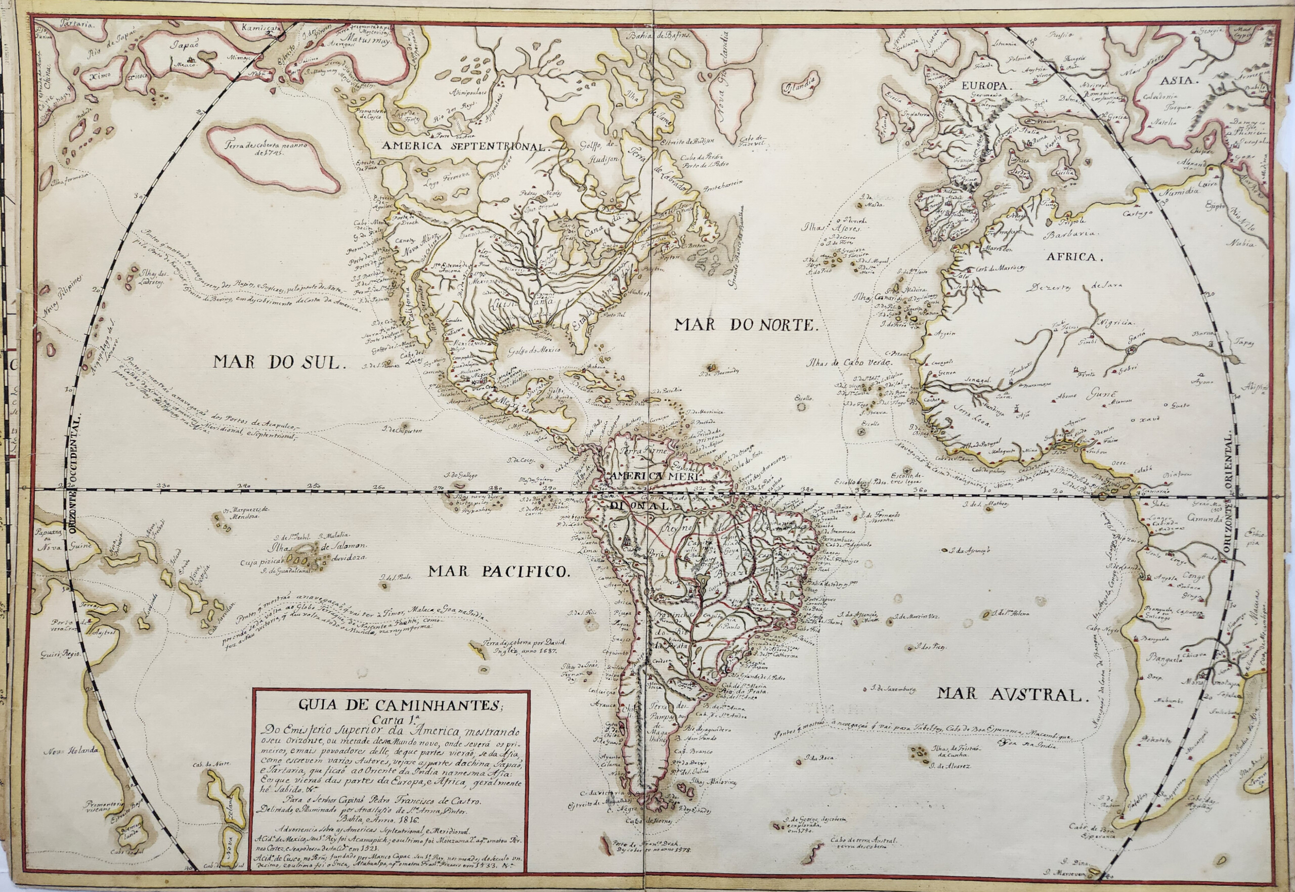
"Of the Upper Hemisphere of America," Map 1 in the Guia de Caminhantes, 1816. Map by Anastásio de Sant'Anna. Courtesy of the National Library of Brazil. Image provided by the author. 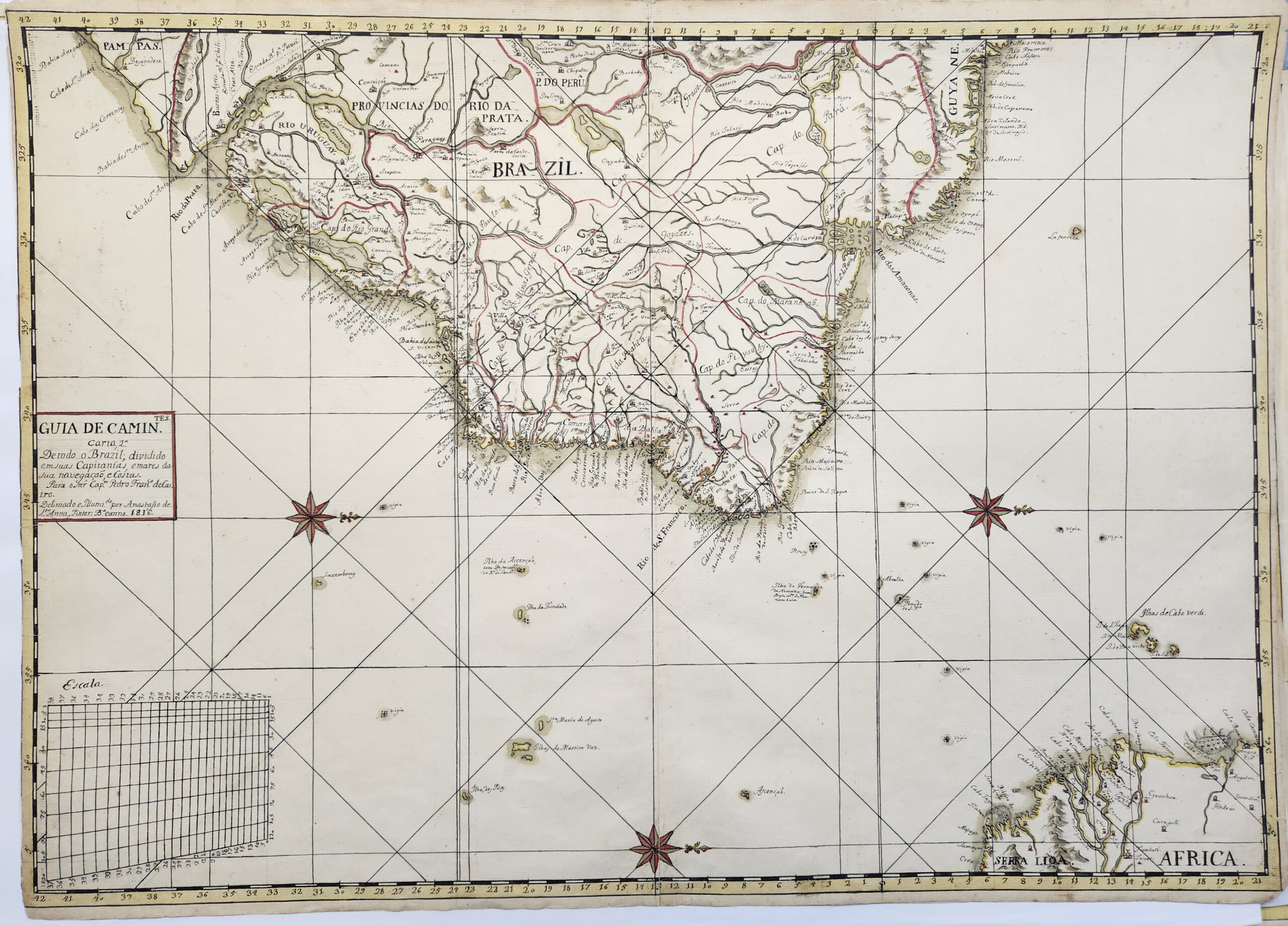
"Of All Brazil," Map 2 in the Guia de Caminhantes, 1816. Map by Anastásio de Sant'Anna. Courtesy of the National Library of Brazil. Image provided by the author. 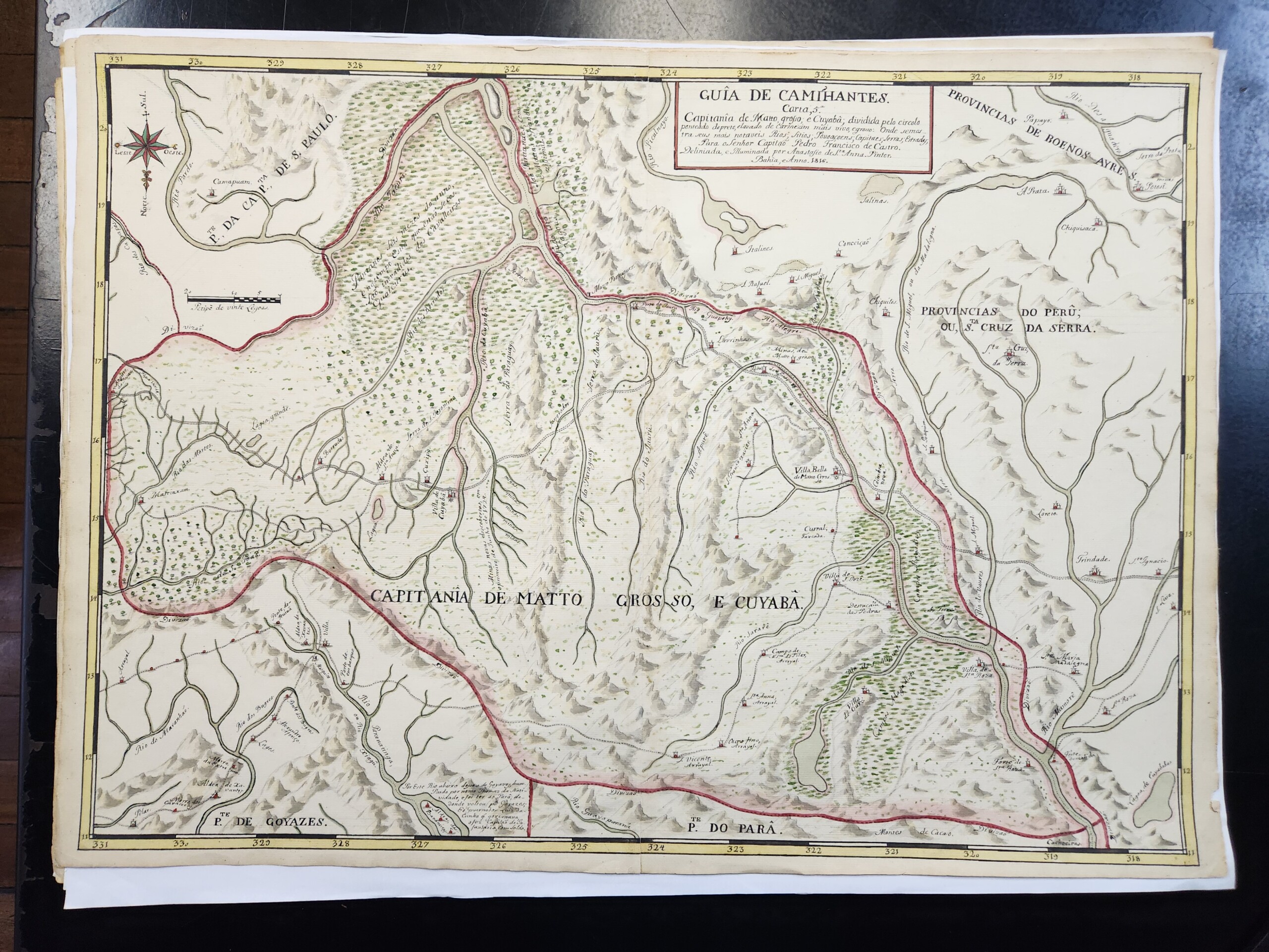
"Mato Grosso and Cuiabá," Map 5 in the Guia de Caminhantes, 1816. Map by Anastásio de Sant'Anna. Courtesy of the National Library of Brazil. Image provided by the author. 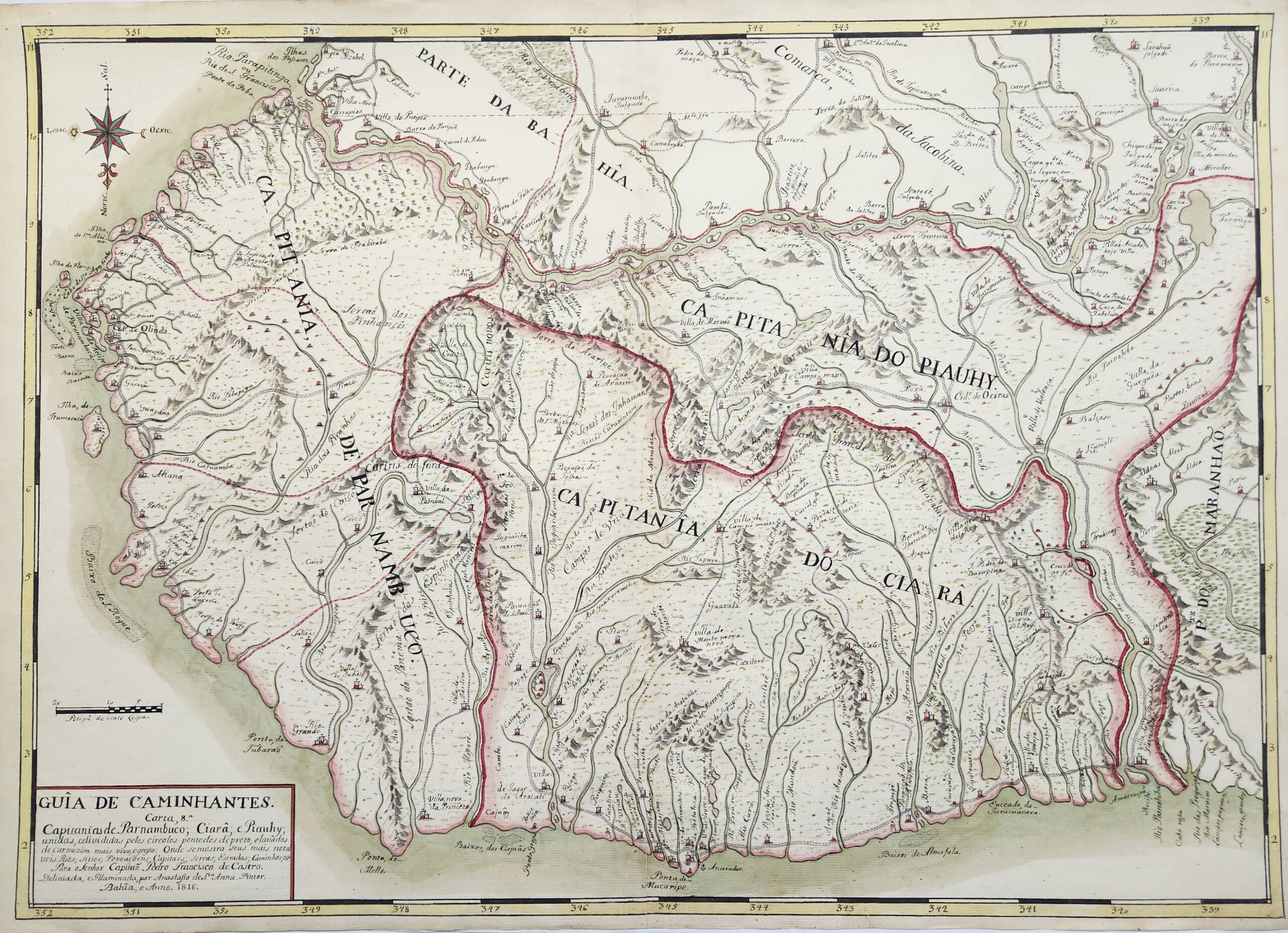
"Pernambuco, Ceará, and Piauí," Map 8 in the Guia de Caminhantes, 1816. Map by Anastásio de Sant'Anna. Courtesy of the National Library of Brazil. Image provided by the author.
The Guia evinces the artist’s intimate knowledge of two centuries of the history of cartography and landscape painting, and these references potently intersect with the social politics around the artist’s racial identity. In turn, as we will see, these maps reproduce and subtly shift conventions of Portuguese military cartography, while also traversing the boundaries between military precision and painterly imagination. Sant’Anna produced, re-framed, and challenged the intersections of empire and racialization in a political and social context in which race strongly stratified—but did not neatly latch onto—the hierarchies of colonial society. In turn, the Guia foregrounds the antiquity and contemporary persistence of Black and Indigenous histories in Brazil and the wider Americas. As if responding to Jefferson’s Uprooted People of the USA more than a century before she produced it, the Guia frames Blackness not as diasporic, but rather as Indigenous to the Americas and in turn constitutive of the modern nation-state. In this way, the Guia starkly contrasts with the maps discussed previously by productively interrogating the opposition of violent colonial cartographies and Black alternative mapping practices. In so doing, it demonstrates how one Black cartographer crafted an intermingled vision of Black, Indigenous, and colonial histories and epistemologies to forge a novel vision of Brazilian national identity on the eve of its independence.
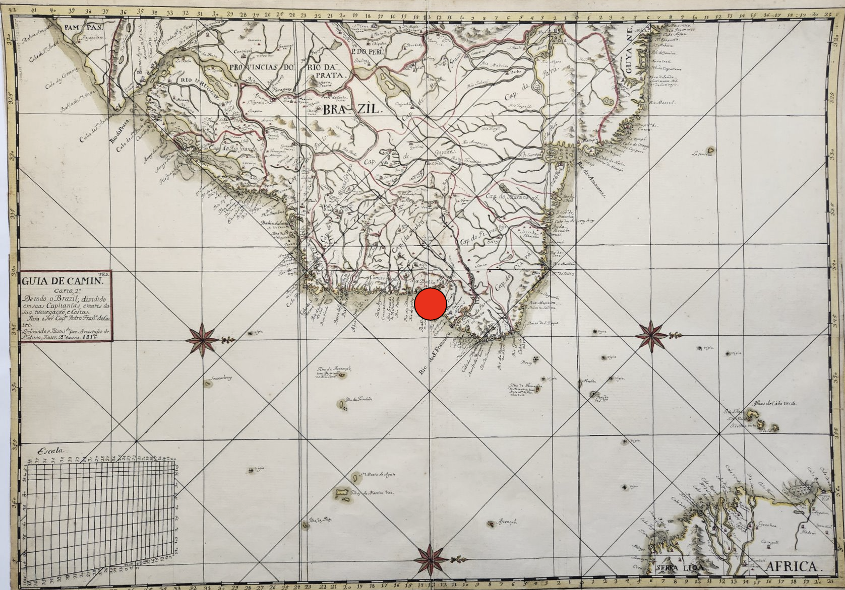
In the Guia’s second map, “Of All Brazil,” Sant’Anna renders latitude with “the city of Bahia” at zero (I’ve indicated Salvador’s location here with a large red dot). The gesture may speak to Sant’Anna’s pride in his home city, but it also testifies to Salvador’s critical political position as Sant’Anna completed the Guia in 1817. Though Salvador had served as the capital of Portuguese colonial Brazil since the mid-sixteenth century, the city had been relegated to secondary status after the capital’s 1763 transfer to Rio de Janeiro, hundreds of miles to the south. Salvador again toyed with primacy in the early nineteenth century as the Portuguese royal court fled the Napoleonic Wars in Europe and temporarily relocated to Brazil, making Brazil the first country in the Americas to house the government seat of a European empire. In 1808, King João VI and his family spent one month in Salvador before moving on to Rio de Janeiro; Rio would remain the Portuguese empire’s temporary capital until the Empire of Brazil’s independence from Portugal in 1822.
The Portuguese Crown’s relocation to Brazil encouraged the colonial settlement of the Brazilian interior, which prior to this period had been predominantly populated by Indigenous peoples who had been displaced by colonial activity on the coast. This means Sant’Anna completed the Guia during a surge of interest in mapping the country’s interior as a proxy for territorial conquest and implicit civilizing. Sant’Anna’s Guia also seems to preface the Brazilian Empire’s 1824 Constitution, which extended citizenship to anyone born in Brazil, regardless of racial background (though this excluded the millions of people of African descent then enslaved in Brazil). Even then, as Sant’Anna completed the Guia, Brazil’s “Atlantic frontier became a theater of staggering anti-Indigenous violence and the entrenchment of African-based slavery” as a byproduct of increased settlement.
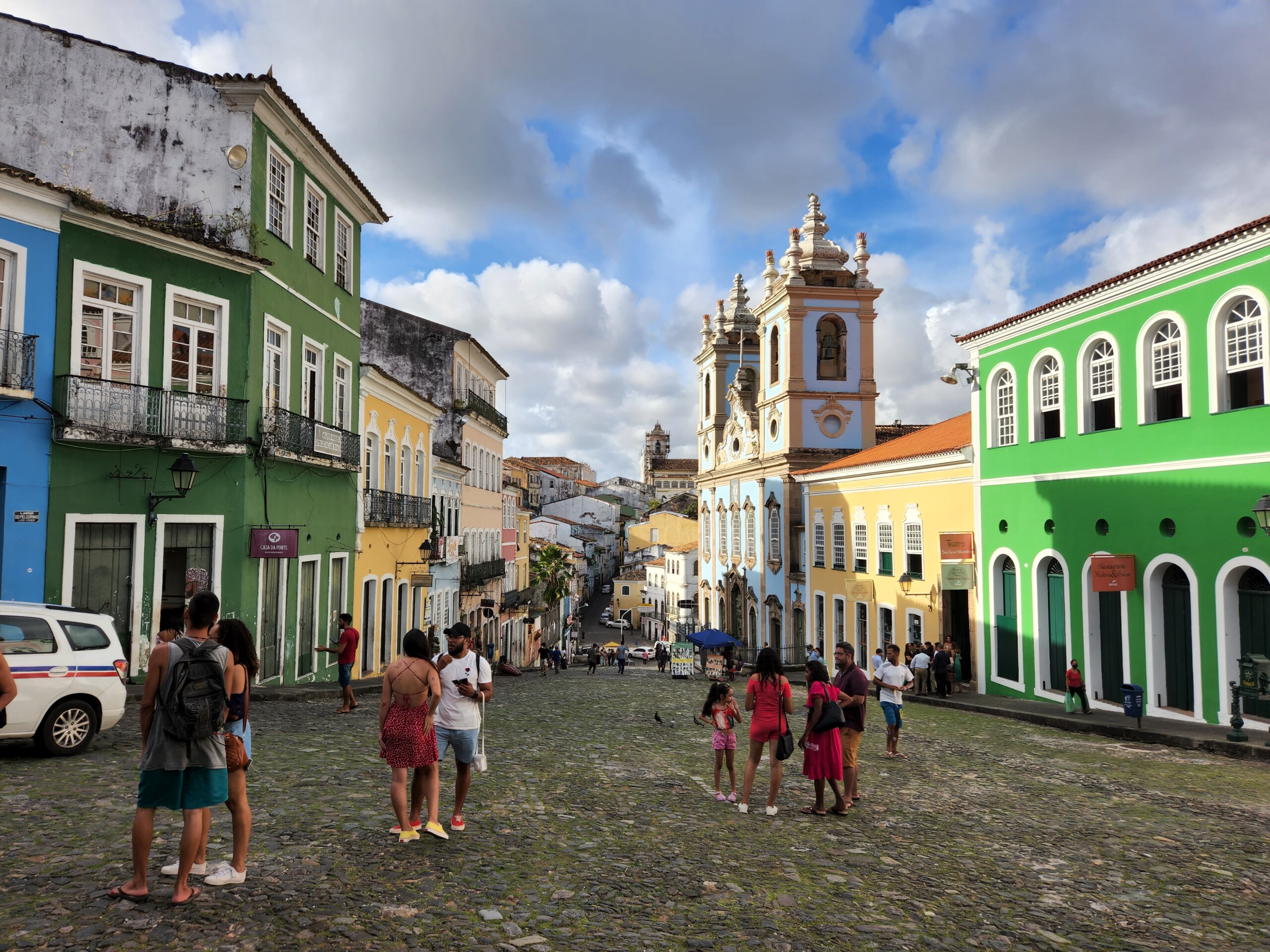
Living in Salvador in the early nineteenth century Sant’Anna would have experienced the political implications of such inequities firsthand. He was part a large, vibrant, diverse Black population in a city that for two centuries had been a major disembarkation point for enslaved Africans in Brazil (and Brazil itself received around forty percent of all enslaved Africans who arrived in the Americas between the sixteenth and nineteenth centuries). In Sant’Anna’s time, two thirds of Salvador’s population was of African descent, enslaved and free, while shipping routes—established around the turn of the eighteenth century—directly linked Bahia with West African ports. Anyone walking around Salvador could see evidence of the city’s African character everywhere: African-born merchants dominated the city’s street economy by selling food and African-made textiles, while African languages were as commonly spoken as Portuguese. Bahia’s African populace also shaped its politics: a series of African-led revolts and conspiracies in early nineteenth-century Bahia shook the foundations of the city’s slavery system and its racial order.
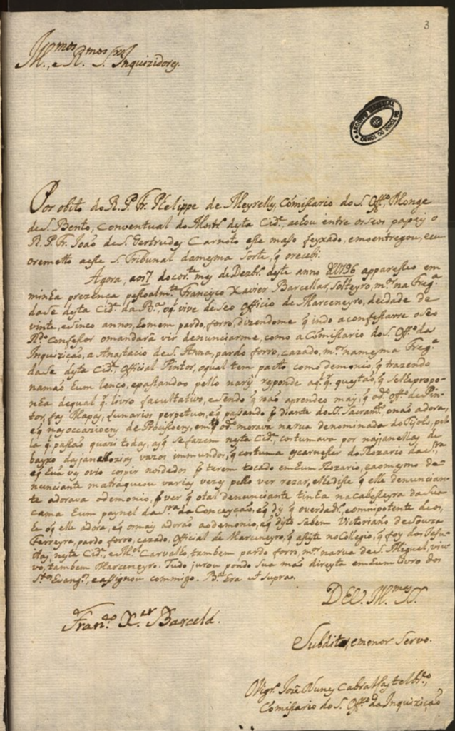
Yet outside of the political and social context in which Sant’Anna worked, we have very little other information about him. Portugal’s National Archive contains the earliest known mention of the artist, albeit when Sant’Anna was likely middle-aged: a 1796 judicial proceeding which named Sant’Anna as defendant. The document describes Sant’Anna as a free married man of mixed race who painted maps and created perpetual lunar calendars. Over two decades before producing the Guia, Sant’Anna was already well known for his artistic and cartographic creations. The document describes him as an “official painter”, a designation suggesting that Sant’Anna was a respected professional and, by implication, an active participant in one of Salvador’s many mixed-race, Catholic brotherhoods. These religious mutual aid organizations that were a staple of Brazilian social life, many of which supported free professional artisans and craftspeople. Specifically Black Catholic brotherhoods had long served as incubators of Black agency in Brazil by purchasing freedom for the enslaved, providing social and economic aid to members, and creating pathways for social mobility and collective solidarity. Sant’Anna’s likely membership in one of these brotherhoods, though, does little to help us understand his political orientations: while directly connected to the rise of Black political consciousness through the nineteenth century, brotherhoods were diverse in their priorities and social orientations.
Attesting to the artist’s commitment to cartography, Caio Figueiredo Fernandes Adan and Iris Kantor have identified a series of unsigned early nineteenth-century manuscript maps of Brazil, which they attribute to Sant’Anna on stylistic grounds.3Caio Figueiredo Fernande Adan and Iris Kantor, A cartografia de um oficial pintor de mapas liberto: Estudo de atribuição de autoria (Bahia-Brasil, século XIX). In 8a SIAHC Siímposio Ibero americano de História de Cartografía/O mapa como elemento de ligação cultural entre a América e a Europa. Edited by Carme Montaner and Carla Lois. Barcelona: Institut Cartogràfic i Geològic de Catalunya, 2012) 120–33. Distributed at archives in Rio de Janeiro, some of these maps appear to be early studies for those found in the Guia, suggesting that the Guia was the culmination of years of study and analysis by the artist; in short, his magnum opus. Yet Sant’Anna’s decades of work in cartography prior to the Guia is striking given that he does not appear to have even been employed by the military or studied military cartography in an official capacity.
I say this because, between the mid-1700s and Brazilian independence in 1822, almost all known manuscript maps of Brazilian territories were produced in the context of military surveying expeditions. Even stranger, the Guia’s maps reproduce some of the major conventions of late eighteenth- and early nineteenth-century Portuguese military cartography: an emphasis on aerial perspective; defined captaincy borders; fastidious naming of rivers and towns; standardized representations of topographic features; and exacting scales for measuring distance. We can see at the bottom left of this map Sant’Anna precise scale for measuring distance; and if we return to the cover page of the Guia, at bottom right, we see his detailed guide for interpreting the symbols and designs on his maps.
These conventions originally emerged from eighteenth-century Portuguese military training reforms that prioritized cartographic training alongside scientific precision and technical uniformity. These military and cartographic reforms went together with desires in Lisbon to increase control over what it viewed as colonial hinterlands. Imperial reforms instituted in the second half of the eighteenth century utilized military cartography as a tool of colonial authority, conducting surveys to identify and suppress rebellious Indigenous and maroon communities while also assimilating inland territories and Indigenous peoples into direct Portuguese territorial control.
Given his lack of military background, Sant’Anna’s work in cartography prompts two questions. One is factual: how did Sant’Anna access the knowledge and military maps necessary to produce the Guia? Other scholars have productively suggested that the Bahia Public Library in Salvador may have provided Sant’Anna access to a range of manuscripts and printed maps on which to base his designs, especially since the library received a large donation of maps in 1812. Sant’Anna also would have had access to the Bahia Military Academy, where interested laymen like him could attend classes on military cartography.
But my hopefully informed speculation on the question of Sant’Anna’s access to military cartography does not answer the second question: why was he interested in mapmaking at all? One clue comes from the Guia’s long opening text, where Sant’Anna describes the Guia as a correction for the “many errors that are found in some imprecise Maps of the interior” of Brazil, by which he means military manuscript maps. Sant’Anna claims the Guia corrects the names of rivers; presents the proper names for towns and settlements; and establishes formerly erroneous latitudinal and longitudinal lines.
However, naming practices are never neutral. Sant’Anna’s Guia throughout makes “a point of giving Indigenous names to places, rivers and cities.” Sant’Anna’s reliance on Indigenous place names does not necessarily signal his investment in a kind of contemporary anti-colonial politics. Rather, I forward that it may reflect the complex and shifting implications of the ongoing Indigenous presence in Brazilian history, one which could be antagonistic to or supportive of colonial projects.
Sant’Anna’s effort to correct the “errors” of contemporary cartography begins not with maps, but with an unprecedented watercolor painting on the bottom left of the Guia’s title page.
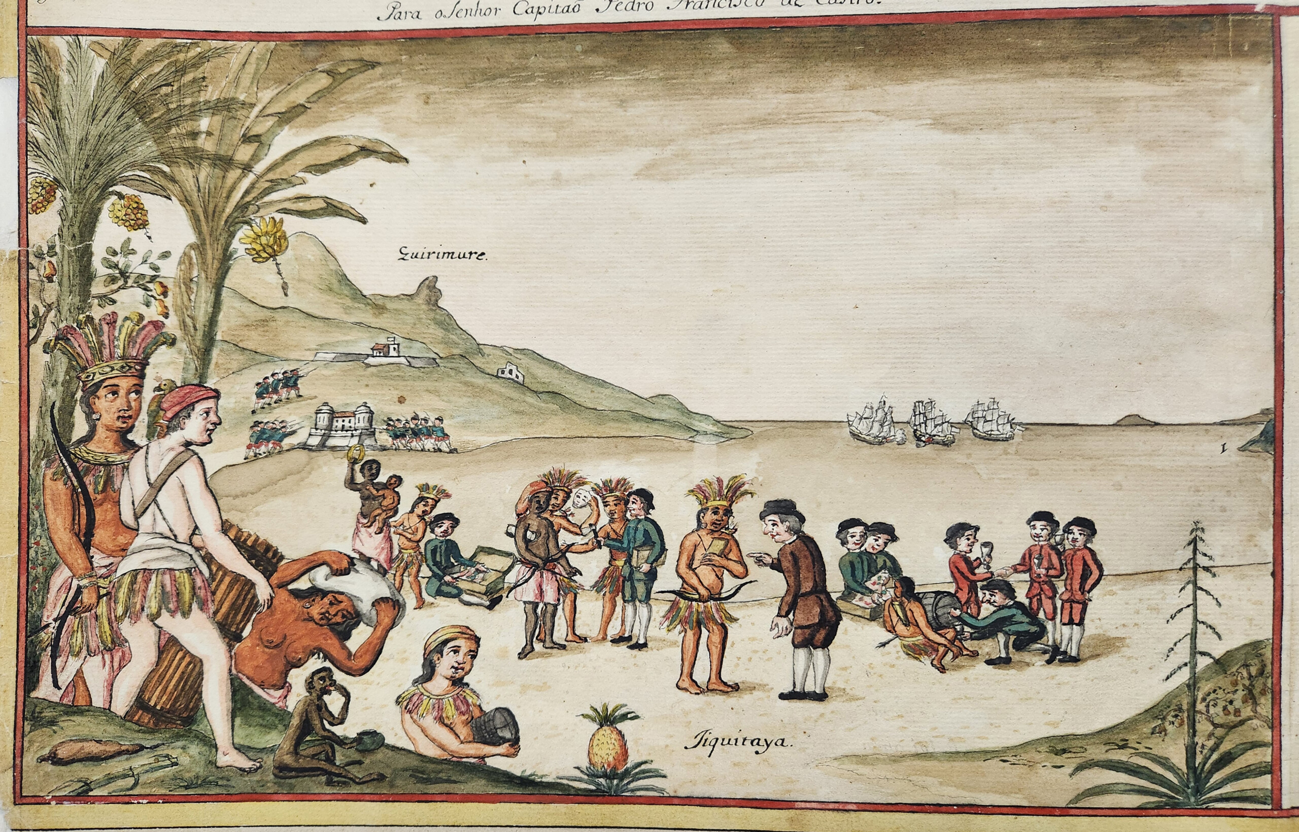
The image depicts an encounter at “Jiquitaia”, described by Sant’Anna as a beach in Salvador formerly known as a thriving commerce center for the area’s Tupi population, the primary Indigenous group of Brazil’s Atlantic coast. Though, in 1817, Jiquitaia was home to a newly-constructed Portuguese military fort —one that still utilized the beach’s Tupi name and so shows the Portuguese imperial appropriation of Indigenous landscapes—Sant’Anna envisions Jiquitaia as a place of ethnic egalitarianism and relative peace. Sant’Anna’s painting presents a group of white European men—identified by their skin tone and their dress—trading weapons, alcohol, and other objects on the beach. Tupi persons, depicted by Sant’Anna with feathered headdresses and skirts, interact on equal footing, as do persons of African descent. The two Black women he depicts appear to be in relationships with Indigenous men; one at left holds their child. In the foreground, a man with skin tone matching the white Europeans emerges with an Indigenous woman from behind a banana tree. His red cap and feathered skirt suggest he has long lived in the area’s Tupi communities.
As the figures on the beach point to trade goods with looks of curiosity and contemplation, and as they wear clothing contemporary to the sixteenth century, the watercolor evokes a sense of initial encounter, as if the Europeans are arriving at Jiquitaia for the first time. Sant’Anna’s title for the painting furthers this reading. “Kirimurê: Ancient Gentilic name of Bahia, and place where the City of Salvador was founded”, references the beginnings of Bahian history while also emphasizing the area’s Tupi name. However, further details complicate this initial timeline. Most obvious is the figure at bottom left, wearing a large feathered headdress, which has been identified as Catarina Paraguaçu, a sixteenth-century “Tupi indigenous woman from Bahia, who was offered by her father, the chief Taparica, to the Portuguese castaway Diogo Álvares, known as Caramuru”, an identification supported by the white figure accompanying her. In turn, Sant’Anna presents Black residents in Kirimurê and shows them as full members of Tupi worlds, even though no enslaved Africans arrived in Brazil prior to the mid-sixteenth century, after the “founding” of Salvador the title references. By including persons of African descent and Indigenous names in the scene at Jiquitaia, Sant’Anna does more than forward a vision of Brazil’s multiethnic history that would soon be enshrined in the 1824 Constitution. He also argues that Bahia’s “founding” is, perhaps, inextricable from the ways Black, European, and Indigenous worlds commingled and co-evolved in Brazil, independent of the histories of exploitative labor and land dispossession that characterized the late colonial and postcolonial imperial periods.
From a contemporary vantage point, this scene of egalitarian encounter appears like an apology or erasure of colonization’s violence. However, looking to the possible inspirations for Sant’Anna’s painting, critical distinctions emerge that show the force of his vision. The painting’s wide-angle landscape view, receding into a bay and framed with Brazilian flora, suggests Sant’Anna’s familiarity with longer histories of Dutch painting used to naturalize and aestheticize Brazilian landscapes and histories of forced labor.
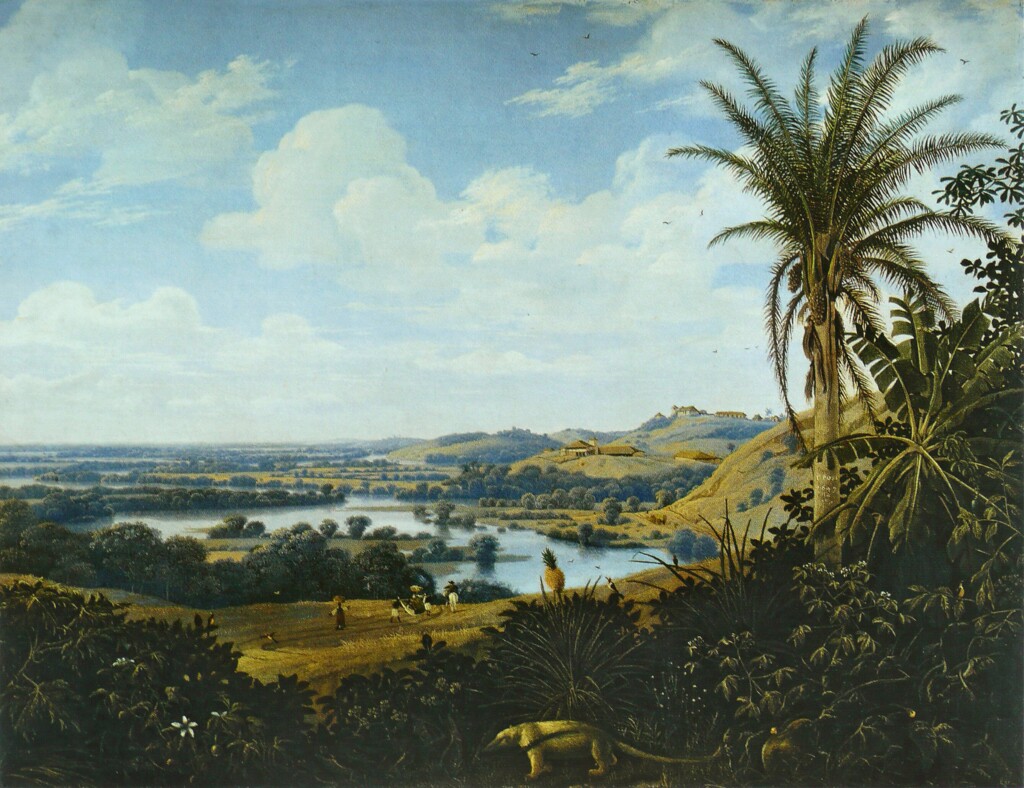
A 1649 painting by the Dutch artist Frans Post testifies to the role of Dutch landscape painting in aestheticizing enslaved labor in colonial Brazil. A wide view looks back to rolling hills punctuated with lakes and rivers. Industrialized sugar mills sit atop the hills at right, while enslaved people work a bit of cleared land at center. Post renders the centrality of industrialized slavery to Dutch Brazil as a natural, aesthetic inheritance of the Brazilian landscape. A small anteater traipses in the foreground, just in front of a prominent pineapple, while a tall palm tree at right – displaying ripe palm fruits dangling from the top—frames the image.
Sant’Anna’s artistic choices (see “Kirimurê” watercolor) suggest a throughline between colonially cultivated visions of tropical, edenic labor and Sant’Anna’s own painting. The foreground pineapple appears once again, as does the framing palm tree, alongside further floral additions like cashew fruits and a banana tree. However, unlike Post, Sant’Anna puts human action squarely in the foreground and emphasizes barter and economic exchange over attempts to aestheticize forced labor. Sant’Anna’s quite literal foregrounding of the word “Jiquitaia” may reinforce the point: the beach’s name is the Tupi word for the powdered form of a chili pepper native to the Americas. Highly desired by the Portuguese who purchased it from Tupi merchants, the chili was soon exported through Portuguese trade routes into Iberia and Africa. By the early seventeenth century, people across the Atlantic world instead called this chili malagueta after an unrelated but equally prized West African spice. Culturally and etymologically, Sant’Anna’s use of “Jiquitaia” harkens less to a pre-contact image of Tupi history than a wide-ranging reference to the co-evolution of Indigenous, African, and European knowledge in and through Atlantic commerce. Fittingly, Sant’Anna does not restrict Black and Indigenous figures to laborers or workers for an invisible white elite—in which the value of their lives would be restricted to their bodily production—nor, in turn, are they portrayed as being in awe of, or saved by, white settlers in the common trope of European saviorism that would run through Brazilian history paintings later in the nineteenth century. Instead, the beach scene places economic and cultural agency in the bodies and minds of Afro-Indigenous histories, while also disentangling sartorial practice and cultural identity from skin tone.
In this way, I read “Kirimurê” as Sant’Anna’s early effort to work through what the Black and Native Studies theorist Sandra Harvey outlines as a key problem in later twentieth- and twenty-first-century Black intellectual history and politics: how articulations of Black identities are often framed around what she frames as “an existential pull … that renders Black existence, especially but not solely outside of Africa, permanently and always already ‘unrooted’”. The counterpoint to that sense of displacement, Harvey notes, is often “the Western nation-state”.4Sandra Harvey, "Unsettling Diasporas: Blackness and the Spectre of Indigeneity," Postmodern Culture, 31: 1, 2 (2020, 2021).) Faced with a tension between Blackness’ uprooting and the patriotic cartography of Brazilian nationhood, Sant’Anna created a painting that refused to place Blackness in opposition to Indigeneity, a point underscored by the inclusion of the Afro-Indigenous child in the scene at Jiquitaia. As I detail below, he constructs a vision of Bahia’s founding that roots Blackness and even African botanicals as Indigenous. And through the presentation of Caramuru, the castaway, he refuses to let whiteness claim the political project of the nation-state, instead showing it as an equal inheritor of diaspora, Indigenization, and forced acculturation.
This vision of the co-constituted Indigeneity of Tupi and Black worlds Sant’Anna presents as constitutive of Brazil may be reinforced in the botanicals he depicts. Cashew fruits, at left (see “Kirimurê” watercolor painting), are native to Brazil, but bananas and pineapples—two fruits that Sant’Anna positions as native in this retelling of Bahia’s founding—were transported to Brazil from West Africa in the sixteenth century. While Frans Post’s mid-seventeenth-century painting participates in a longer colonial strategy of cultivating visions of botanical hybridity to aestheticize and naturalize the violence of settler colonialism, Sant’Anna reframes foreign transplants—which include human beings and cultivated plants—as altogether native to Bahia. This is what separates Frans Post from Sant’Anna: the latter asserts the antiquity of Indigenous and African shared knowledges and harkens to a diverse, vibrant world that includes them both, independent of histories of European domination. However, complicating this reading is another background detail showing how Sant’Anna continues to play with timelines: a battle scene likely referring to the 1625 joint Spanish–Portuguese reconquest of Salvador following its Dutch occupation. Perhaps Sant’Anna is collapsing the major events of Bahia’s history here, but it also speaks to the proto-nationalist tone of his Guia by re-envisioning the moment when Bahia was brought back under Portuguese imperial sovereignty, a point that may have carried strong weight as Brazil served as temporary home to the Portuguese Crown.
Why might Sant’Anna be asserting this vision of Afro-Indigenous antiquity and Brazilian national and imperial pride all at once? What motivated his project to imagine the political contours of Blackness outside of a diasporic framing?

Sant’Anna’s self-description on the cover page as a “painter” as well as an “old pardo” may reveal much about his intent. Pardo, a Portuguese word which has no translation into English, is the general term still preferred by multiracial Brazilians to describe themselves. In the early nineteenth century, pardo indicated a person’s African—and potentially also Indigenous—ancestry, but also more generally referred to someone who was neither white (branco) nor Black (preto), with the latter term typically suggesting enslaved status. As was true throughout colonial-era and early imperial Brazil, vocabularies and self-definitions of color were often “more to indicate social positions than referring specifically to an individual’s nature.” In this sense, pardo was often equivalent to mulato—another term referring to multiracial ancestry—but mulato carried stronger pejorative connotations. Sant’Anna’s upbringing in the second half of the eighteenth century took place around what the historian Miguel A. Valerio outlines as a “popular notion that mixed-race Afro-Brazilians constituted colonial Brazil’s most deviant and unruly socioracial group.” In this context, Valerio elaborates, those who could often expressed a “preference for the term pardo instead of the sullied one of mulato, [which was] popularly associated with licentiousness and ungovernability.”5Miguel A. Valerio, "The pardos’ triumph: The use of festival material culture for socioracial promotion in eighteenth-century Pernambuco," Journal of Festive Studies 3:49, 2021.
Sant’Anna’s self-definition may be related to his artistic prowess. Pardo artists in late colonial Brazil had greater access to artistic work and exploration and so could pursue opportunities unavailable to darker-skinned Brazilians in the late eighteenth and early nineteenth centuries. However, Sant’Anna may also have been invested in showing the role of pardos in the formation and participation of a nascent Brazilian national identity, as well as negotiating their political position in the midst of the movement of the Portuguese court and the African rebellions at the time he created the Guia. Sant’Anna’s sole reference to racial categories in the Guia is telling in this regard.
The Guia’s fifth map,depicting the captaincy of Mato Grosso in central Brazil, contains an intriguing detail along the bottom edge. Here, Sant’Anna relays the story of Tomás da Natividade, a pardo man, who was made a salaried infantry captain by the governor.
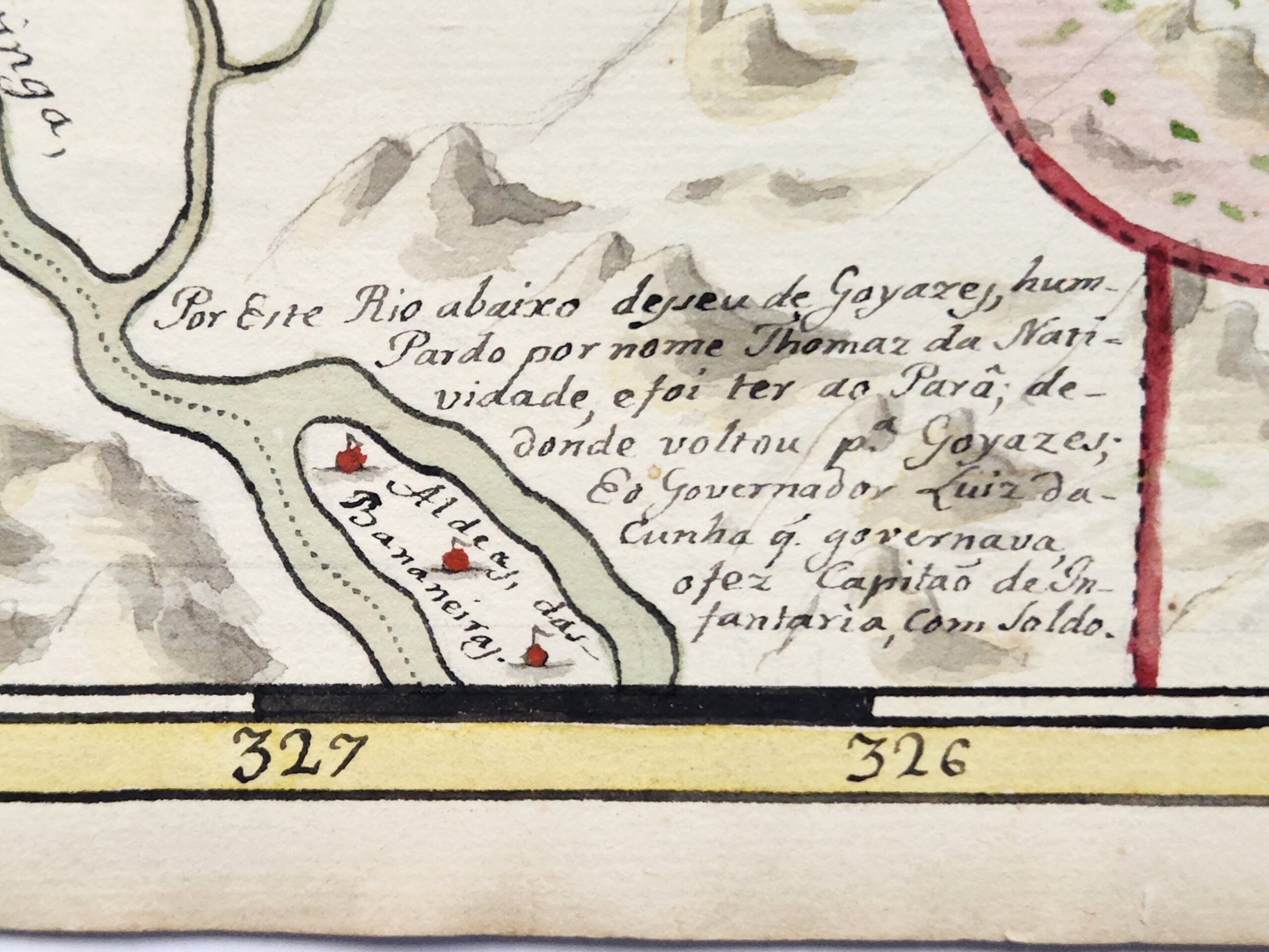
Why would Sant’Anna have gone out of his way to relay this little-known story? Did Sant’Anna delineate Natividade’s race as pardo—same as the artist—as a testament to his social position, either by status or by aspiration, to prove pardos’ participation in the construction and maintenance of the Brazilian state? Did Sant’Anna also testify to the position of pardos in a social context where they routinely faced barriers in compensation for their service in colonial conflicts? Intriguingly, Sant’Anna may have known pardos in Bahia as both artisans like him and militia members: at the time he completed the Guia, 60% of Salvador’s fourth militia regiment, which was reserved for mixed-race Brazilians like Sant’Anna, were employed as artists. Three were painters. But all likely held far less wealth than their white counterparts in the second regiment. While mixed-race Brazilians were common in Portuguese militia ranks, as were Indigenous Brazilians, their racial status posed frequent barriers to earning full salaries and land rights. And finally, might the reference to Natividade here remind the Guia’s readers of the political differences between Africans and Brazilian-born creoles like Sant’Anna, none of whom participated in the Bahia rebellions, and indeed, were likely among the militiamen who suppressed an African-led uprising near Salvador in 1816, just as Sant’Anna began work on the Guia?
Small details like this begin to put the viewer on notice of the multiple, overlapping political interventions in Sant’Anna’s work. This continues in the first manuscript map of the Guia: a planisphere of the Americas.
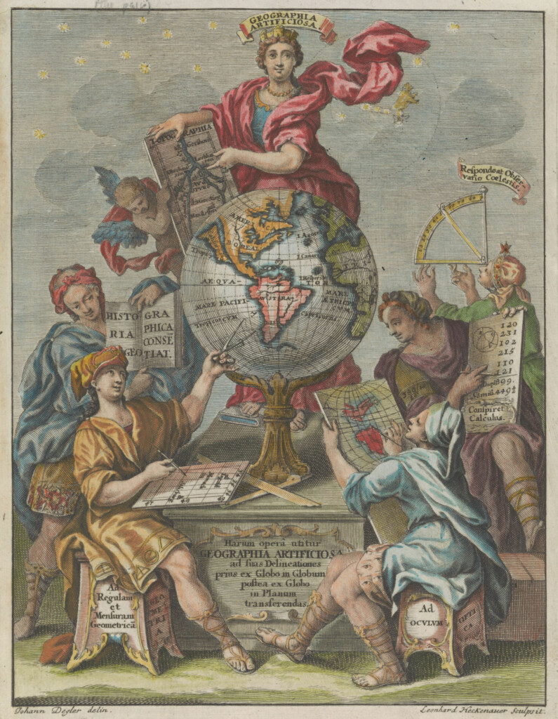
As art historian Tatiana Reinoza has outlined, the planisphere was deployed as a technology of what she calls the “Western cartographic gaze” and a proxy for territorial conquest and racial hierarchization reproduced on countless travelogues and cartography manuals dedicated to the colonization of the Americas, as we see in this 1703 frontispiece.6Tatiana Reinoza, Reclaiming the Americas: Latinx Art and the Politics of Territory (Austin: University of Texas Press, 2023): 18. Yet here, the map’s cartouche at bottom center—typically the domain of colonialist fantasies about Americas as an unpopulated territory prepared for the wide implantation of European settlements, or the deployment of figures that confine and define Indigenous and Black labor—instead emphasizes Indigenous empires. Sant’Anna’s text notes the “city of Mexico” and the “city of Cusco”, capitals of the Aztec and Inca states, respectively, their first and last rulers, and those rulers’ undoing by the Spanish in 1521 and 1533. Again, Sant’Anna not only highlights the antiquity of Indigenous civilizations here, but even asserts a new theory of the peopling of the Americas: Sant’Anna titles his map as actually identifying the “parts” from which those who populated the Americas came: “if from Asia, as various authors write, see the parts of China, Japan, and Tartary …and those who came from … Europe and Africa”. Sant’Anna collapses the entire history of the Americas’ peopling, putting all histories of forced and voluntary migration on equal footing while, importantly, decentering Europe spatially and discursively.
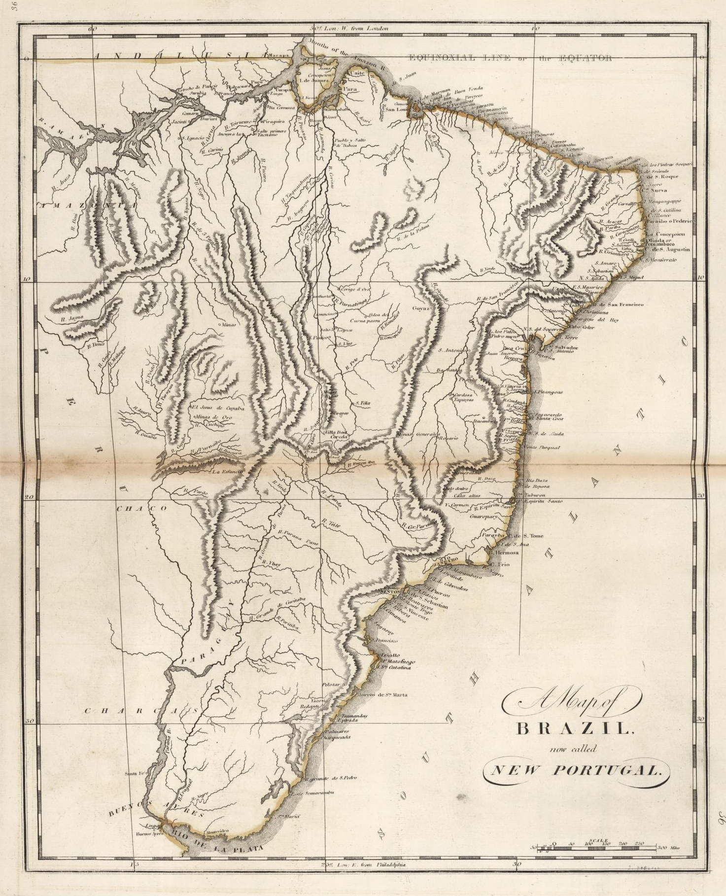
Sant’Anna’s map of Brazil, second in the Guia, further suggests his inspiration from much earlier works. Most maps of Brazil at this period were oriented with north at the top, while also outlining the Atlantic coastline and fleshing out the country’s interior: moves reflective of a kind of cartographic proto-nationalism that sought to form Brazil into an identifiable territorial boundary prior to independence in 1822. Such maps helped to render the nation as what the historian Sumathi Ramaswamy calls a “geo-body” necessary for would-be citizens to “see” the country politically and, in turn, to socially attach themselves to it.7Sumathi Ramaswamy, 2014. Maps, Mother/Goddesses, and Martyrdom in Modern India. In Empires of Vision: A Reader. Edited by Martin Jay and Sumathi Ramaswamy (Durham: Duke University Press, 2014): 420.This scheme was then reproduced on a global range of engraved and teaching maps after Brazilian independence, such as this example produced in Philadelphia in 1818 (below, left).
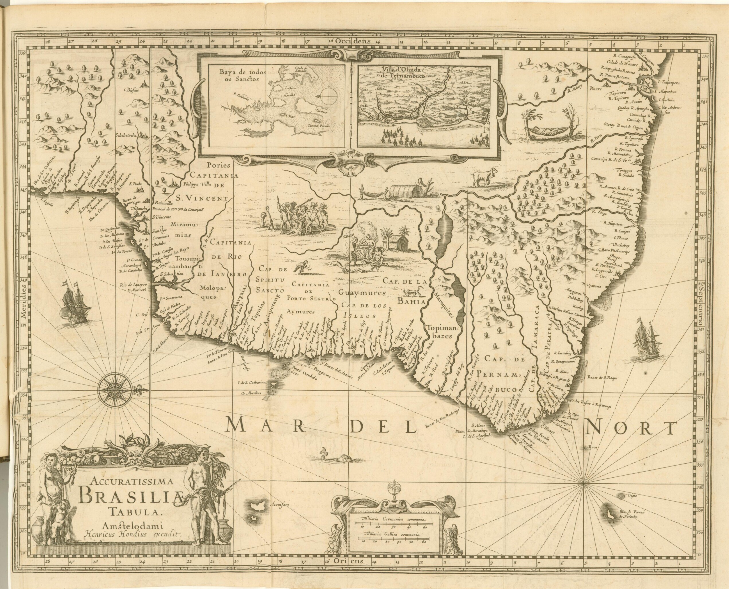
Sant’Anna’s Brazil breaks from this schema, orienting west at the top, a change that neither formed part of Sant’Anna’s corrective efforts nor would have been reproduced in any contemporary work. This style harkens to the sixteenth and seventeenth century, where European—especially Dutch—colonial cartographers commonly oriented Brazil with west at the top, such as in the 1644 example (above, right), which became the basis for nearly a century’s worth of maps in its wake. Also note here that this map contains a prominent inset, at top, depicting the bay of the city of Salvador, and so further speaks to Sant’Anna’s Bahia-centrism.
Sant’Anna’s Brazil also reduces the size of the Atlantic Ocean so that the west African coast peeks through the bottom right. This required shifting of the spatial dynamics from the planisphere the map before, suggesting the move is intentional. This style of showing the tip of Africa with Brazil emerged in the 1500s. Common through the middle of the eighteenth century, this style emphasized Brazil and Africa’s proximity to imply the facility of trafficking humans and goods between them.
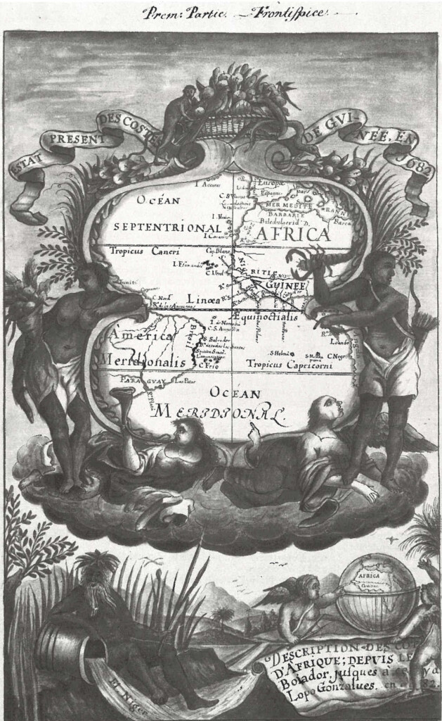
In some cases, the link was explicit: the frontispiece to French trader Jean Barbot’s 1688 travelogue concerning his time in West Africa depicts the ocean as a connector between Brazil and West Africa, while two Black figures—aesthetic, celebratory archetypes of the slave trade—flank it. Yet this singular framing of Brazil and West Africa had effectively disappeared by the early nineteenth century. Is Sant’Anna here continuing to extol the slave trade as the backbone of Brazil’s economy—potentially a point that could further distance his racial subjectivity from associations with slave status? Might he also be subtly referencing Brazil’s strong African presence, something further suggested by the oversize importance given to Africa in the planisphere, where the continent almost dominates a map purportedly focused on the Americas? And if so, how does this detail operate in tension with the scene at Jiquitaia, which effectively refuses an image of Blackness tied to Atlantic slavery or diasporic African origins?
Sant’Anna’s eighth map, which depicts northeastern Brazil, may further testify to his work’s historical references and the multilayered histories of diaspora that inform it. Again, shifting typical orientation conventions by depicting northeastern Brazil with south at the top – he loves playing with perspective and directionality – Sant’Anna includes a critical detail: at the bottom of the map, he paints a small black building and labels it “Tapera de Angola; or Palmares.”
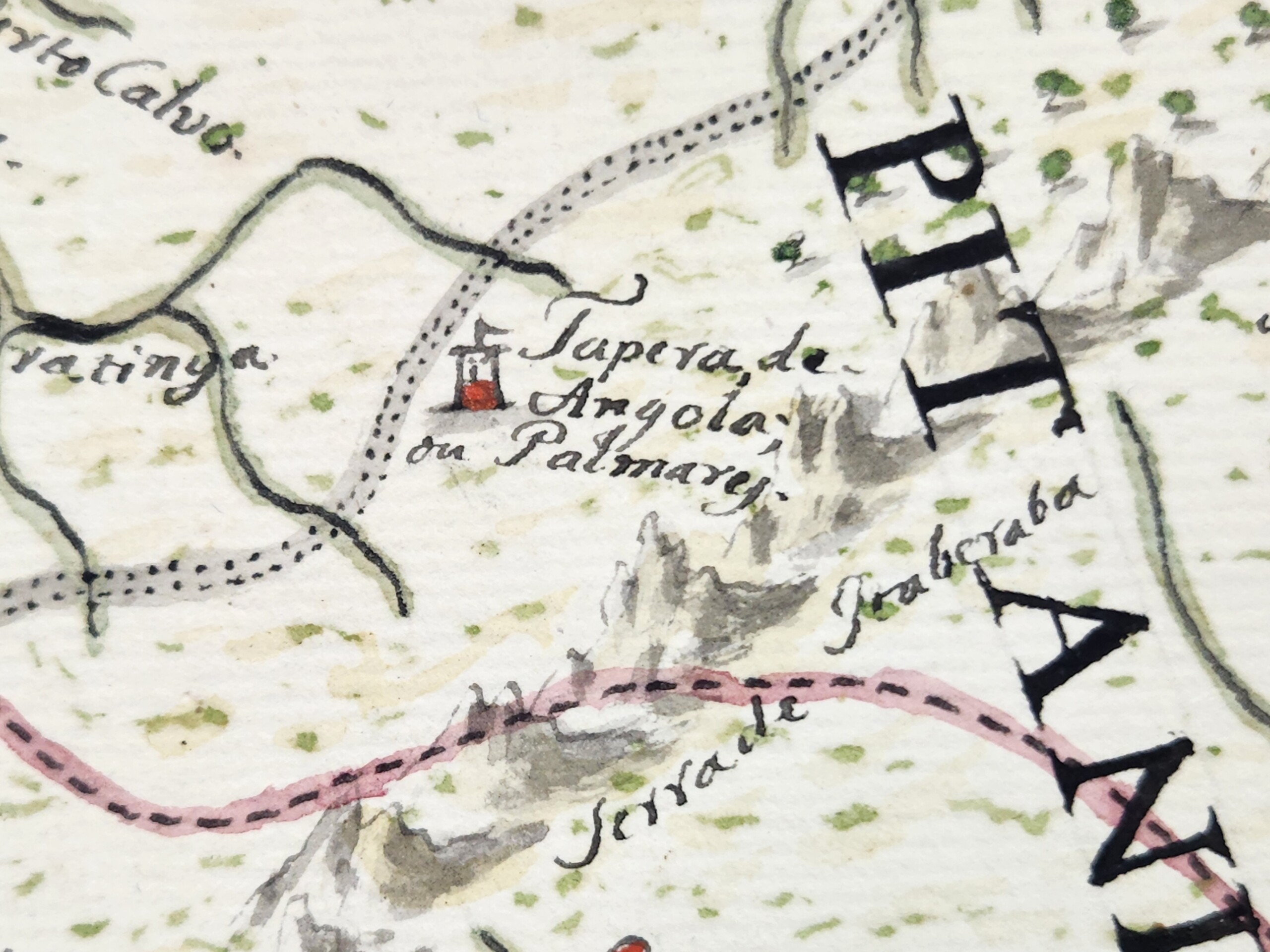
Palmares is the common name for a collection of maroon polities that existed in this region during most of the seventeenth century. At its height, Palmares had a population of many thousands, and was politically powerful enough that it conducted major conflicts and signed treaties with the Portuguese and the Dutch. Yet Palmares’ assumed destruction in 1695 means that it was an atypical location to be referenced on a map of the early nineteenth century. Indeed, only one other known map from Brazil’s entire colonial period—a map of this same region commissioned in 1766—names Palmares.
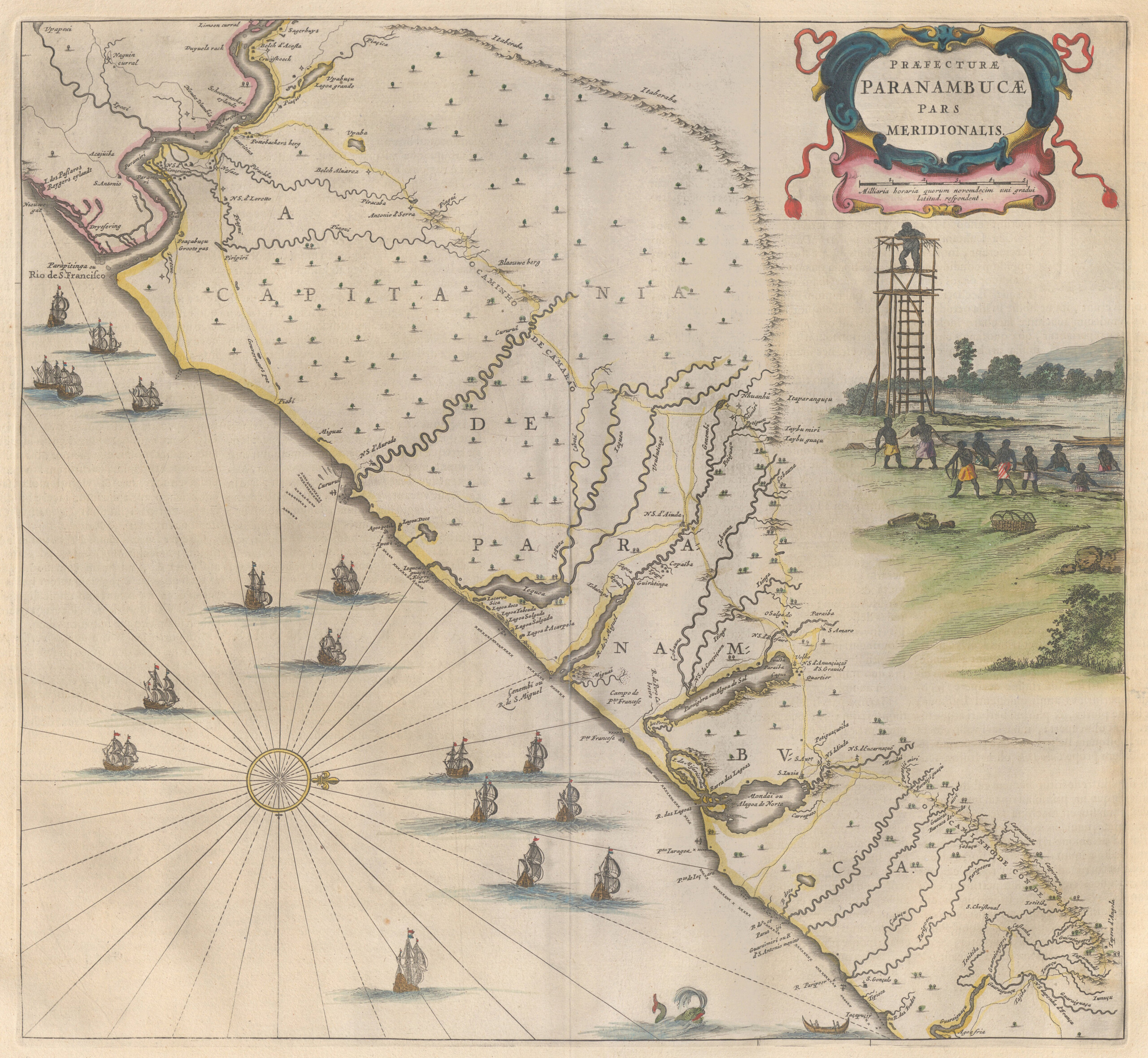
Moreover, the Guia’s pairing of “Tapera de Angola” and “Palmares” is unique in the history of cartography. The name “Tapera de Angola” only appears on one other known map: at the far bottom right of Dutch cartographer Joan Blaeu’s oft-reproduced 1662 map of northeastern Brazil, depicting the region’s occupation by the Dutch in the mid-seventeenth century. Sant’Anna’s use of this phrasing suggests he used Blaeu’s map specifically as a source of inspiration, nearly a century-and-a-half after its production (and in turn further supports the idea that Sant’Anna is taking broad inspiration from seventeenth-century Dutch Brazilian visual culture).
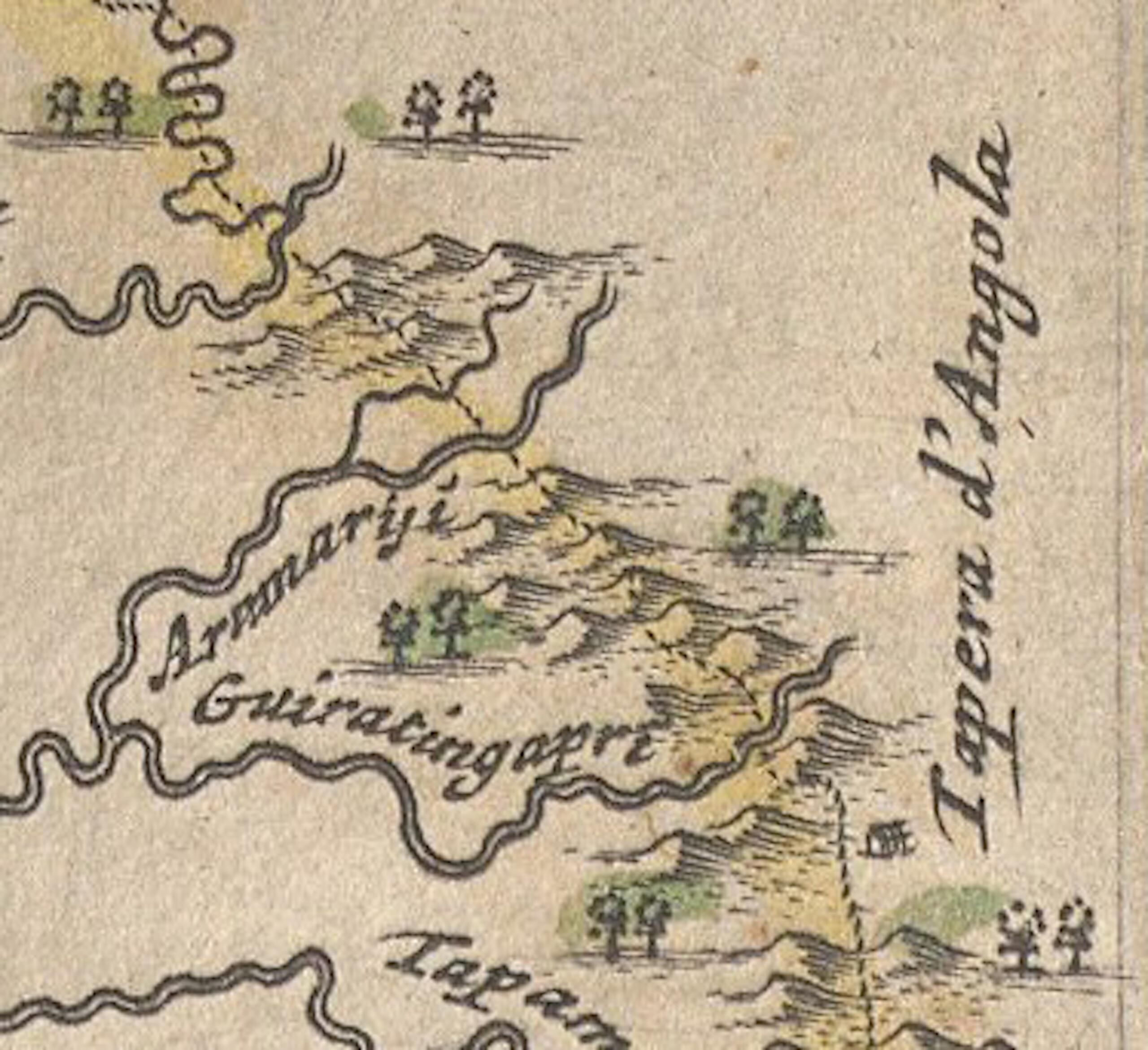
Naming Palmares in this way may have carried special resonance for Sant’Anna’s evocation of Brazil’s constitutive Afro-Indigeneity. On one level, “Tapera de Angola, or Palmares,” brings into intimate relation phonemes from three languages: “tapera”, an Indigenous Tupi word referring to a ruined or destroyed settlement; “Angola”, the central African polity strongly associated with Palmares, and the region commonly cited as its cultural and philosophical origin point; and “Palmares”, the Portuguese term for palm trees. Sant’Anna uniquely intermingles these sounds on the map, as if linguistically reproducing the kind of multiracial egalitarianism painted on the Guias’s frontispiece. Beyond the multivocality Sant’Anna’s naming provides, we cannot know how Sant’Anna understood the words’ meaning. Did he know, for example, that “tapera” referred to an abandoned settlement? What might this have meant for his evocation of “Angola” and the suggestion that this African polity, or at least its memory, existed or was even at home in Brazil—yet another iteration of the continent’s vibrant proximity to, and co-constitution of, the Brazilian state? If Sant’Anna did understand Palmares as abandoned or destroyed, what might he suggest by re-naming it here and connoting the potential for regeneration and new settlements in the area, maroon and colonial alike, long after Palmares’s destruction? And finally, how might we put this point in conversation with Sant’Anna’s insistence that previous cartographers had made “imprecise” maps of the interior of the state? Why did he make a specific choice to emphasize this historic terminology, and thus bring into sharp relief the coeval histories of Black, Indigenous, and white European diasporas? As elsewhere, Sant’Anna’s work provides few clear answers. Yet, perhaps it is precisely his emphasis on multilayered, multi-referential ambiguity, and the strategic intermingling of colonial, Black, and Indigenous epistemologies that provides the Guia its force.
I want to conclude with the words of geographer Chérie N. Rivers, who writes that “To explain [one’s] origins in relation to a modern political map is to accept a specific construction of space and time that imprisons [oneself] in the geography of global power.”8Chérie N. Rivers, To Be Nsala’s Daughter: Decomposing the Colonial Gaze (Durham: Duke University Press, 2022) 31. For Rivers, the line drawing and mapmaking of longstanding colonial relations presumes a geographic and spatial fixity that attempts to force racial subjectivity into a kind of essentialized boundedness and, in so doing concretize its utility for political and economic exploitation. Anastácio de Sant’Anna worked in the wake of cartographic projects of the colonial Americas which resonate deeply with Rivers’ argument about attempts made to codify and subdue racial identities in the service of proto-nationalist imaginaries, slavery economies, and military conquests. Yet, as “real” maps attempted to instantiate racial hierarchy, practices of Black fugitivity and independence threw them into ontological crisis. As outlined at the beginning of this essay, the work of theorists of Black Geographies show the consistent inadequacy of maps produced in the service of colonial projects, either by intentionally obscuring forms of resistance embedded in the very landscapes they represented, or by failing to incorporate—as a function of their medium—the manifold processes by which those in diaspora exist and move in and remember the world.
In its foregrounding of Black and Indigenous histories and placenames, in its evocations of Africa’s proximity to Brazil, and in its presentations of Blackness’ Indigeneity to Bahia, we might see in Sant’Anna’s Guia an effort to visualize those very forms of place- and space-making obscured by colonial military cartography; to, in other words, re-map and re-animate Black and Indigenous lives beyond the confines of the modern political map. The Guia explores and disentangles the historical timelines, diasporic histories, and racial imaginaries that pushed its maker to occupy a subjective position in the racial strata of the Portuguese Empire and the nascent Brazilian state. In this way, perhaps the Guia functions less as a political statement than as Sant’Anna’s attempt to work through the contours of a racial and political schema that asked him to choose between his mixed-race ancestry and his patriotism, or between his Blackness and his rootedness in and patriotism to Bahia. The Guia interrogates the extent to which cartography may not erase, but rather could foreground, a vision of Black history as part of the state’s geo-body. The Guia may not signify “an outright rejection of the colonial geographic and cartographic project as much as an underscoring of its inadequacy”, which might “distinguish patriotic art’s investment in the map form from the state’s command mapmaking ventures.” Through his genre-bending experimentations across painting and cartography, Sant’Anna attempted to rethink the genealogy of cartography in his homeland, all while asserting his—and other pardos’—sense of belonging and centrality to it. 
About the Author
Matthew Francis Rarey is associate professor and chair of the Department of Art History at Oberlin College. He is author of Insignificant Things: Amulets and the Art of Survival in the Early Black Atlantic (Duke University Press, 2023). This Southern Spaces presentation is derived from an essay published by Professor Rarey in Arts in 2024, available here.
]]>Introduction
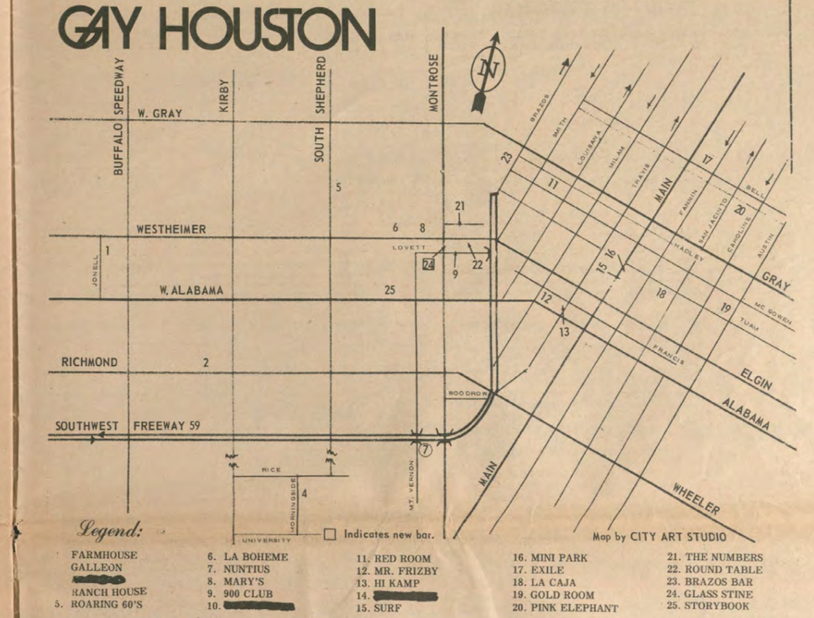
What role does cruising play in marking specific areas of the urban landscape as "queer territory"?1For the purposes of this essay, I use the word "queer" primarily in its capacity as a contemporary umbrella term intended to include the panoply of non-normative sexual and gender identities concatenated in familiar and unpronounceable acronyms like LGBT, LGBTQ+, and LGBTQQIAA. To be sure, other speakers and thinkers deploy "queer" with additional senses—an historical term of derision, a specific identity, a verb. The word can summon all these thoughts and more, regardless of authorial intention; indeed, it can carry whatever freight we readers bring to it. When I intend these specific meanings in this text, I will do my best to flag them. In general, I argue our politics and communities benefit most when we embrace the untidy polysemy of "queer" and explore the openings it provides. Since the 1970s, social scientists have proposed and critiqued various models of queer territorialization. Martin Levine used spot maps of bars and cruising grounds to substantiate a "gay ghetto"; Jen Jack Gieseking analyzed individuals' "mental maps" of queer space; Amin Ghaziani critiqued the enclave theory of "gayborhoods" in favor of what he terms "cultural archipelagos."2Martin Levine, "Gay Ghetto," in Gay Men: The Sociology of Male Homosexuality, ed. Martin Levine (New York: Harper and Row, 1979), 196–218; Jen Jack Gieseking, "Queering the Meaning of 'Neighbourhood': Reinterpreting the Lesbian-Queer Experience of Park Slope, Brooklyn, 1983–2008," in Queer Presences and Absences, eds. Yvette Taylor and Michelle Addison (London: Palgrave Macmillan, 2013), 178–200; Amin Ghaziani, There Goes the Gayborhood? Princeton, NJ: Princeton University Press, 2015; Amin Ghaziani, "Cultural Archipelagos: New Directions in the Study of Sexuality and Space," City & Community 18, no. 1 (2019): 4–22. All these models of queer territory posit collective understandings of place that transcend the social boundaries of queer identity groups.
All three authors also reference cruising, but offer little detail about how cruising works in their models. Using the city of Houston as an example, this essay attends to cruising as an underdeveloped aspect of those models. As Houston's Montrose neighborhood came to be identified as a "gayborhood" between 1960 and 1980, archival evidence shows that cruising narratives played a powerful role in that identification. At the same time, these narratives also show that queer territorialization in Houston was not a smooth process of collective place claiming and recognition. Rather, dissent and conflict over the practice of cruising in Houston shows queer place claiming to be fractured, contested, and structured in part through a politics of respectability inflected explicitly by class but curiously silent on race. Importantly, that fractured and contested structure is due in part to the converging efforts of a wide array of disparate agents: queer sex-seekers, Houston residents, local politicians, civic groups, queer organizations, national anti-pornography groups, and conservative political movements. These narratives also point to complicated relationships between cruising and other markers frequently used to define queer territory, specifically businesses serving a queer clientele.
Cruising: Practice and Concept
Cruising takes the art of the flâneur—passing time watching people, usually in public—and imbues it with the additional potential or explicit purpose of finding a sex partner. As Alex Espinoza has evocatively described, cruising can lead to sex in situ, whether in public locations like parks or semi-public locations like restrooms, but often leads to sex elsewhere in more private spaces.3Alex Espinoza, Cruising: An Intimate History of a Radical Pastime. Los Angeles, CA: Unnamed Press, 2019. It can also happen inside commercial establishments that charge a fee to access other clientele in a semi-private space, like bathhouses, video arcades, and adult book stores. Out of doors, cruising can happen both on foot and, after the popularization of the automobile, by car as well. Cruising is also associated strongly but not exclusively with gay men. In our information age, dating websites and hookup apps on mobile phones—Grindr, Scruff, Growlr, Boyahoy, Jack'd, and others—seem to remove much of the guesswork (but definitely not all the danger) from divining who might be nearby and looking for the same thing. Many men seeking men for sex today came of sexual age through these digital tools, leading writers like John Fielding to ask whether the prominence and distribution of cruising as a queer social practice has waned as a result.4"In the Age of Grindr, Cruising and Anonymous Sex Are Alive and Well," Vice, January 7, 2016, https://www.vice.com/en/article/qbv5n3/cruising-in-the-age-of-grindr-828.
While this essay centers upon the importance of cruising in a particular place and a past era—Houston between 1960 and 1980—the rich scenes it describes should not be misconstrued to suggest that cruising is a thing of the past. Rather, contemporary popular culture, high art, literature, pornography, and vernacular speech continue to reproduce face-to-face cruising in public as part of a globally available gay sexual vocabulary and social practice. Espinoza's Cruising movingly shows the practice is not of a bygone era or one in which only certain (morally questionable) people engage. His book has received critical acclaim in part for its temporal and global scope—ancient Greece, England, Russia and Uganda receive specific attention—but also for his sensitivity both to disability and Latinx experience, as well as his assertion that cruising can offer contact across class and racial lines. That assertion echoes Samuel R. Delany's analysis of cruising in New York as a form of "contact" in Times Square Red, Times Square Blue (1999).5John Birdsall, "Review: 'Cruising' maps the cultural history of L.A.'s hookup spots," Los Angeles Times, July 3, 2019, https://www.latimes.com/books/la-ca-jc-review-cruising-alex-espinoza-gay-history-20190703-story.htm. In short, cruising persists as a culturally relevant practice in the United States and elsewhere, one that often moves across social boundaries and identity categories.
Men seeking men for sex has never been the sole determinant of queer territory. For those who know how to read it however, both then and now, cruising marks public and semi-public spaces as at least temporarily queer(ed) territory. This marking is how cruising functions not only as a social practice but also as a concept. Through documenting the disparate networks of people who came to meet on Houston's cruising grounds—intentional sex-seekers, criminals exploiting stigmas attached to gay sex, ambivalent law enforcement officials, area denizens, and perhaps initially naïve passersby—I argue that the social distribution of knowledge about cruising illustrates that queer territories functioned in part because some who do not identify as "queer" also imagined those territories as connected to queer lives.
This distributed social knowledge is the kind of information that Levine described under "culture area," that Gieseking captured through "mental mapping," and that Ghaziani articulated through his concept of the "cultural archipelago." Although similar in emphasis, these theorists differ significantly in how they imagine the process of place claiming. Levine borrows four criteria from the sociologists Robert Park and Louis Wirth to assess the status of a "gay ghetto": institutional concentration, culture area, social isolation, and residential concentration. Levine mapped bars and cruising areas listed in Bob Damron's 1976 Address Book to illustrate institutional concentration, and conducted a literature review and "exploratory fieldwork" in those concentrated areas to assess the remaining three criteria.6Levine, "Gay Ghetto," 185. His "exploratory fieldwork" consisted of walking around neighborhoods observing gay life and talking with gay people, activities quite parallel to cruising itself. Particularly in his assessment of culture area, Levine describes a remarkably smooth process of place claiming. Within the culture area, "open displays of affection [between men] rarely evoke sanctions; for the most part, people either accept or ignore them. Even police patrols through these spaces pay little attention to such behavior. . . . In other places, such behavior quickly elicits harsh sanctions."7Levine, "Gay Ghetto," 204.
By contrast, Gieseking and Ghaziani attend more closely to a multiplicity of perspectives, change over time, and conflict in social descriptions of place. Gieseking defines mental mapping as "the representation of an individual or group's cognitive map" of a specific place.8Jack Jen Gieseking, "Where We Go From Here: The Mental Sketch Mapping Method and Its Analytic Components," Qualitative Inquiry 19, no. 9 (2013): 712. While most of Gieseking's work is credited as "Jen Jack," this article flips those names. In visualizing both multiple individuals' and group perceptions' of a place, Gieseking finds that mental sketch mapping can "afford participants and researchers alike a way to share and see more multidimensional stories of themselves and their experiences through the lens of space and place."9Gieseking, "Where We Go From Here," 723. For his part, Ghaziani observes that "new residential and leisure queer spaces are forming across the city, and beyond its borders as well." That multiplicity of spaces grounds his proposal "that we redirect the study of sexuality and space away from our preexisting assumptions of spatial singularity—evinced by a steady stream of publications about individual gay districts—toward a cultural archipelagos model of spatial plurality."
Although Levine's work gives an important foundation, the history of cruising in Houston more closely exemplifies the social dynamics Gieseking and Ghaziani describe. During the twenty-year span centered on the 1969 Stonewall riots in New York, cruising narratives in Houston exhibit a multiplicity of opinions about a multiplicity of spaces, even as public awareness of the Montrose neighborhood as "gay" solidified both locally and nationally. This essay analyzes mainstream and queer sources of the time to construct and juxtapose two datasets: a GIS-enabled mapping of historical queer business data and an archive of narratives of cruising. While the business data offer one visualization of queer territory in Houston, narratives of cruising exceed the capacities of that mapping. Cruising areas have complex relationships to commercialized spaces—sometimes directly connected, at other times peripheral and symbiotic, and at others seemingly divorced. At the same time, these seven cruising narratives I feature here illustrate that efforts to regulate cruising converge from multiple, conflicting sources, including queer newspapers and community10Like "queer," "community" is also a freighted word. While I use it in this essay as a shorthand, I encourage readers to be cautious about the degree of coherence, agreement, organization, and unity they take it to convey. organizations with a range of stances toward queer life.
Mapping Queer Houston
I first came to live in Houston in 1997. When I arrived, the Montrose neighborhood was the epicenter of a thriving queer community. It was home to the largest concentration of Houston LGBT bars as well as many non-profit organizations, from the Montrose Counseling Center to Pride Houston. There were two queer bookstores, a free monthly magazine, and several free weekly papers. Soon, I was working for one of those papers, distributing copies all over the city. That labor helped me question and reimagine my first assumptions about the distribution of queer life in Houston. In this car-addicted place, queer bars and businesses were not just in the trendy Montrose neighborhood, but in far-flung suburban strip malls as well. Even so, Montrose remained the symbolic core.
That was not always the case. In 1911, J. W. Link and his business associates platted and marketed the Montrose Addition as an upscale suburb for middle- and upper-class Houstonians to escape the dirt and heat of the urban core. The Link Mansion built at the corner of Montrose and Alabama streets to advertise the new neighborhood was for some time the most expensive private home in Houston. To understand better how Montrose shifted from that elite suburb to a "gayborhood," I began a project in 2014 inspired by Levine's spot maps. I built a database of over 400 historical queer businesses11The definition of "queer business" here deserves some nuance. The database captures businesses explicitly marketed to a queer clientele. Historical queer advertising usually depicts that clientele as gay men and lesbians, often but not always as separate populations rather than a single market. Businesses were included in the database if they advertised in a Houston-based publication aimed at a queer readership or appeared in a national directory such as Damron's Address Book. This is not to say that queer community owned each business or that queer community was the only clientele. This nuance also matters when thinking about the relationship of cruising to commercial space, whether or not that commercial space can be thought of as queer. identified in Houston's historic queer publications like The Albatross, The Nuntius, and This Week in Texas, and supplemented those publications with other historical sources. I cross-referenced these locations through Houston's city directories to confirm the length of time each business was in operation at every street address given for it. Some bars relocated, for example, often after a fire. Using ArcGIS, I visualized that database from 1941 to 2015 on a contemporary base map of Houston to help orient present day viewers. Finally, I sequenced the 74 maps into a short animation.[2] 12Brian Riedel, "CSWGS Where is LGBTQ Houston?" YouTube video, 3:15, March 15, 2018, accessed December 31, 2019. https://www.youtube.com/watch?v=baSgYQtkTSI&feature=youtu.be&ab_channel=RiceUniversity. This animation was also displayed at Houston's Heritage Society in 2015 as part of the six month installation "Throughout: Houston's GLBT History."
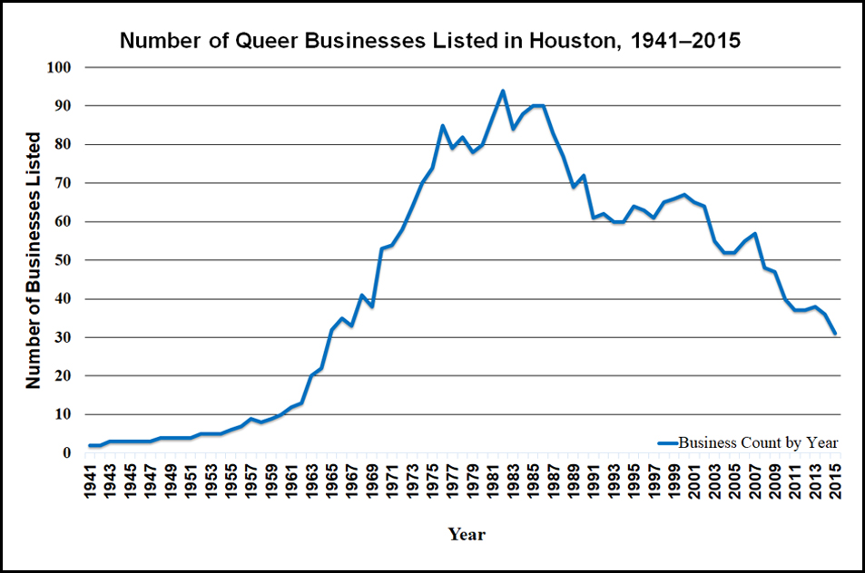
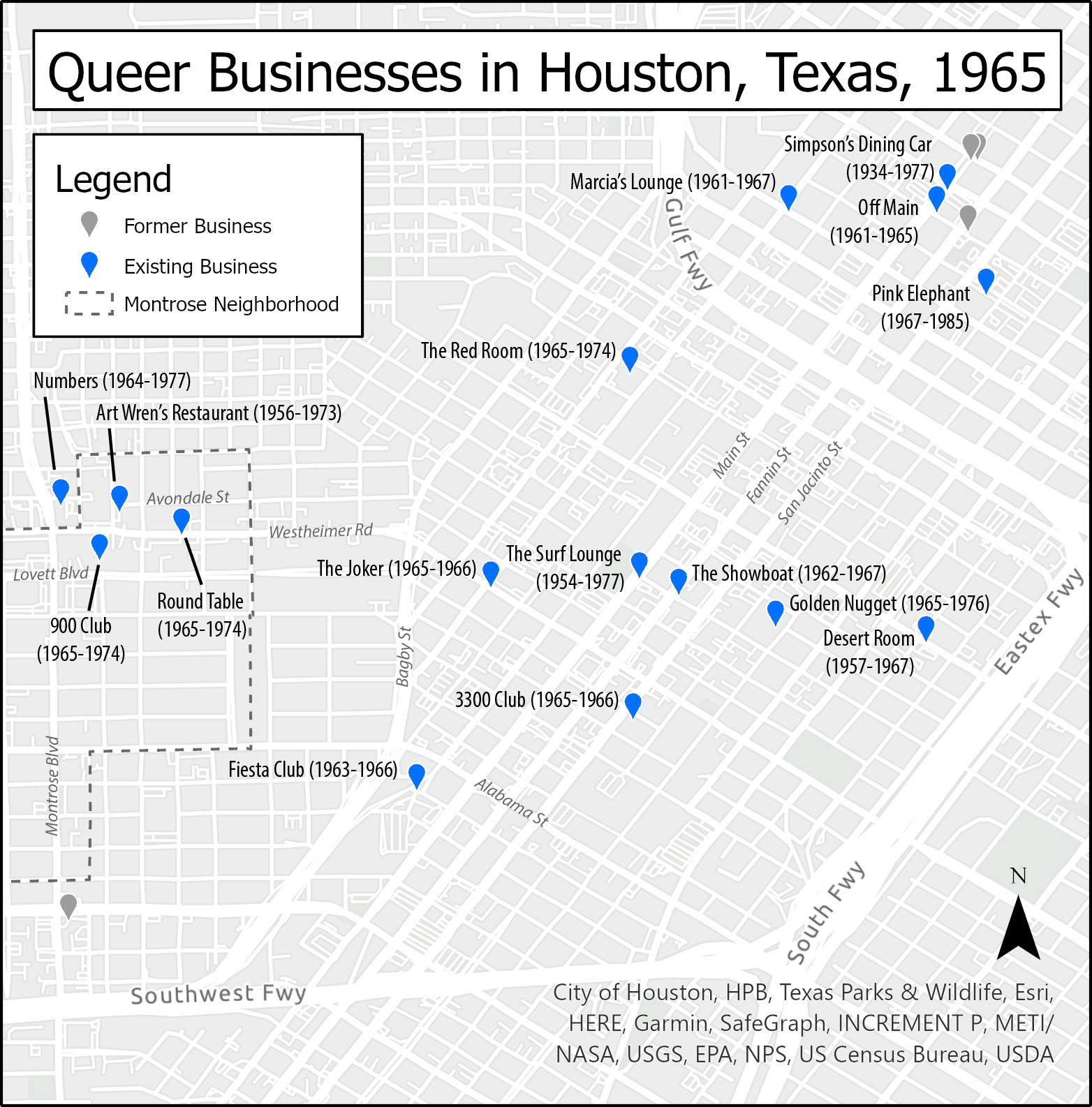
That animation suggests several phases to describe Houston's queer geography and history, phases that can also be visualized through a graph of businesses over time (see graph below). From 1941 to 1955, most businesses catering to queer community (though often not exclusively) operated in downtown, present-day Midtown, or the Rice Village area. The first location in Montrose was Art Wren's, a diner that ran from 1956 to 1971. Art Wren's also gained a national profile; it is one of nine "interesting" Houston locations listed in a 1962 souvenir program of the League for Civil Education's drag fundraiser in San Francisco, "Michelle International."13"Michelle International," League for Civil Education, accessed December 31, 2019, https://www.queermusicheritage.com/fem-michelle.html. Of the nine locations listed for Houston, I have been able to confirm locations for six. Beyond those six, I can confirm an additional seven locations not included in the souvenir program. That Art Wren's is among those six speaks further to the strength of its reputation. Here, "interesting" served as code for "gay"; the words "gay" and "homosexual" never appear in the League's program, even though the drag event raised money to help those arrested in raids on gay bars. By 1969, Houston's queer center of gravity was clearly shifting toward Montrose, but Midtown and downtown were still quite active. By the 1980s, the intersection of Westheimer Street and Montrose Boulevard was the center of queer life in Houston, and new bars and businesses began opening further west and into suburban areas. Even as the geographic distribution of queer spaces widened, the total number of locations peaked at 94 in 1982. During the 1980s, Houston endured the double impact of HIV/AIDS and the long economic fallout of the 1981 oil bust. The number of queer businesses began to stabilize at around 60 in 1991, but would begin dropping again at the turn of the twenty-first century. Montrose remained the dominant center as that number continued to taper. In 2015, just 31 businesses were operating, fewer than Houston had at the time of the Stonewall Riots.
Helpful as it is for visualizing change in queer Houston over time, this mapping project has significant limitations for the kinds of queer community it can be assumed to depict. Just at the level of "queer businesses," a mafia-owned bar with a partially queer clientele in the 1950s is not exactly the same kind of queer business as a lesbian-owned bar in the 1980s that hires a security firm to watch the parking lot.14See "Kindred Spirits," Houston LGBT History, accessed October 1, 2020, http://www.houstonlgbthistory.org/misc-kindred.html. While such a 1950s bar could be any of those Carl Wittman laments in his "Gay Manifesto," the 1980's bar I mention here is quite specific. Marion E. Coleman started Kindred Spirits in Houston as an answer to many lesbians' problems with the bar options then available. She also hired a security firm to guard the parking lot and screen customers. Also, attending only to bars and businesses can skew our perception of queer space along class-inflected lines; professional middle-class and upper-class lesbians and gays eschewed the bar scene as dangerous for some time, even as recently as the 1990s.15See the letter writer to ONE below. In Houston, that pattern structured the Dianas, an almost exclusively white, upper-middle-class social organization of mostly gay men that originated in 1953 as an Academy Awards watch party in a private home.16"History of the Diana Foundation," Diana Foundation, accessed December 31, 2019, https://thedianafoundation.org/page/history-of-the-diana-foundation. That same pattern of discretion also influenced the creation of the Executive and Professional Association of Houston, founded in 1978.17"The Executive and Professional Association of Houston," EPAH, accessed December 31, 2019, https://www.epah.org/. In the more than 300 oral histories gathered through the Old Lesbian Oral Herstory Project, many lesbians—particularly those in middle-class professions like nursing and teaching—preferred softball and house parties to bars as ways to meet other women.18"The Old Lesbian Oral Herstory Project," OLOHP, accessed December 31, 2019, https://olohp.org/index.html. OLOHP owes a great deal to Arden Eversmeyer who trained women to collect oral histories across the United States. I am also indebted to an anonymous reviewer for bringing my attention to The New Orleans Dyke Bar History Project, accessed October 1, 2020, http://www.lastcallnola.org/. Those oral histories document a different perspective: some lesbians in 1970s and 1980s New Orleans preferred to meet each other in bars. See also John Howard's edited volume Carryin' On in the Lesbian and Gay South (New York: NYU Press, 1997). Mapping bar locations sourced in a mostly white-oriented gay press also elides Black, Indigenous, and other People of Color, along with their specific networks and practices.19For example, see see E. Patrick Johnson, Sweet Tea: Black Gay Men of the South, (Durham: University of North Carolina Press, 2011) and Black. Queer. Southern. Women. (Durham: University of North Carolina Press, 2018).
Beyond these limitations, the academic literature on queer territory also suggests the animation should account for the role of cruising as a place-claiming practice. Levine specifies cruising as a form of "institutional concentration" in his model of the gay ghetto, and even symbolizes cruising areas on his maps.20Levine, "Gay Ghetto," 1979. Levine also discusses cruising in chapter 4 of Gay Macho (New York: NYU Press, 1998). However, they appear as static present entities; he does not inquire into their pasts or their futures. Gieseking also positions cruising as one element in the creation of queer territory21Jen Jack Gieseking, "A Queer Geographer's Life as an Introduction to Queer Theory, Space, and Time," in Queer Geographies: Beirut, Tijuana, Copenhagen, ed. Lasse Lau et al. (Roskilde: Museum of Contemporary Art, 2013), 4–21. but takes care elsewhere to mark the limitations of both cruising and any emphasis on territory for the analysis of women's communities.22Gieseking, "Queering the Meaning of 'Neighbourhood,'" 2013. Ghaziani's There Goes the Gayborhood? briefly mentions cruising, framing it as an activity that could occur in any number of venues in the urban landscape.23Ghaziani, Gayborhood, 13. Ghaziani redeploys that same formulation of cruising in a more recent essay while arguing for "a cultural archipelagos model of spatial plurality" as an antidote to "enclave thinking." He argues that "the spatial expressions of sexuality are becoming more diverse and plural."24Ghaziani, "Cultural Archipelagos," 7. Though my mapping project did not visualize cruising areas, the research behind it did surface many narratives of cruising. Analyzing these cruising narratives in parallel with the mapping project, I argue that together they offer strong evidence to support Ghaziani's archipelagic model of queer territorialization in Houston at various moments across the twentieth century. Rather than any single enclave as figured in the footprint of Montrose, for example, these seven cruising narratives point to multiple, contested queer territories spread across Houston in memory and practice.
1930s: "Window Shopping"
The Houston queer press archive offers glimpses of cruising practices and mental maps that pre-date the temporal frame of my mapping project (1941–2015). In a 1988 article from the Montrose Voice,25"Montrose Voice," University of Houston Digital Libraries, Houston Texas, accessed October 1, 2020, https://digital.lib.uh.edu/collection/montrose. The Montrose Voice was published in Houston from 1980 to 1991. For readers unfamiliar with Houston's queer press history, I strongly recommend browsing the JD Doyle Archives, accessed October 1, 2020, http://www.jddoylearchives.org/. Richard Van Allen relates stories from men who lived in Houston before World War II, and recounts a queer urban geography through their eyes:
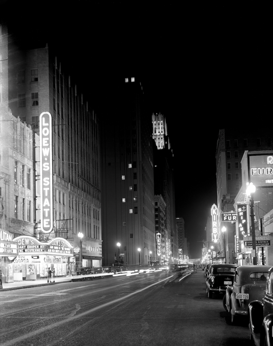
"The 'gay circuit'—they didn't know the word 'gay'—was downtown Houston, between Franklin and McKinney and Main Street east to San Jacinto. You could not tell a queer or a fag (the words they used then) from the straight, which was the way the gays wanted it, being fearful for their lives and jobs."26Richard Van Allen, "Houston's Gay Thirties," Montrose Voice, no. 410, September 2, 1988: 9. https://digital.lib.uh.edu/collection/montrose/item/8166/show/8130. This article has echoed in Houston media since then. See also William Michael Smith, "Looking Back at Some of the Hurdles Houston's Gay Community Had to Overcome (Part 1)," June 20, 2014, http://www.houstonpress.com/news/looking-back-at-some-of-the-hurdles-houstons-gay-community-had-to-overcome-part-i-6736836; "Houston's Earliest Gay scenes (Part 2)," Houston Press, June 23, 2014, http://www.houstonpress.com/news/houstons-earliest-gay-scenes-part-2-6748546; "'The Homosexual Playground of the South' (Part 3)," June 24, 2014, http://www.houstonpress.com/news/the-homosexual-playground-of-the-south-part-3-6737870.
Aside from a few bars that, while not intentionally or exclusively gay, served as gathering spaces to those in the know—the Rathskeller, the Old Vienna, the Capitol Bar, Rex's27Sadly, Houston city directories from the 1930s and 1940s did not confirm the addresses and locations for the bars documented in this article, so they are not included on the map. It is tempting to assume they fall within the sixteen-block area described by Van Allen.—what then functioned as queer "territory" was out on the street in that sixteen-block rectangle. According to a man Van Allen calls Dan:
"Of course, we didn't know the word 'cruising' then. We called it 'window shopping' and just like now, you know who was gay and who wasn't without asking. You could feel it, whether they had a limp wrist or not. There was this post down in front of Levy's department store. It had mirrors on four sides, and queers would stop and comb their hair there. Oh, you could spot them. If we did want to trick, we could get a room at the Milby or the Texas State Hotel. More often we went home to our apartments."
Much as Ghaziani describes "the closet era" of "scattered gay places"28Ghaziani, Gayborhood, 12–13. Ghaziani credits the second phrase as Ann Forsyth. prior to World War II, Dan's recollection of imagined gay space is opportunistic rather than exclusive. The social ecosystem of commercial downtown spaces—semi-public bars, shop windows, mirrored posts, and semi-private hotel rooms—created opportunities for strangers to meet for sex while providing a degree of plausible, respectable deniability. Gay networks circulated in parallel with other networks, but at least in Van Allen's account, cruisers would often move across the city landscape to more private spaces after meeting in more public ones.
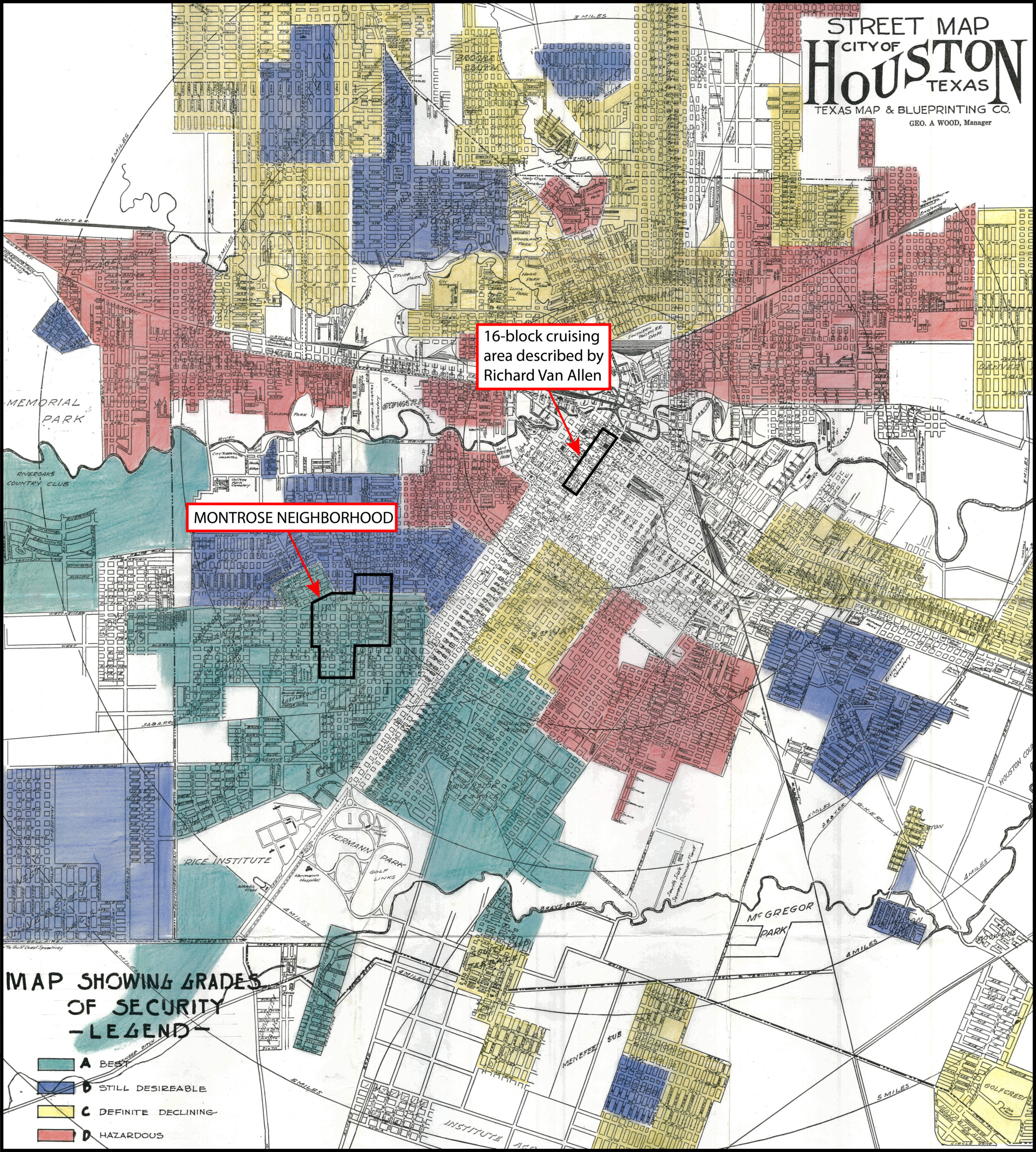
A striking way to situate this "window-shopping" area and the Montrose neighborhood in relation to the rest of 1930s Houston is to superimpose them on a now infamous Home Owners Loan Corporation map from the same era (see map above). The areas shaded red indicate the "hazardous" parts of town, where Black residents tended to live, and where the Home Owners Loan Corporation would not insure mortgage loans. The Montrose neighborhood, some two decades old at the time of this map and mostly shaded green, was the "best" type of neighborhood in which to live. Situated at the city's commercial core, the sixteen-block cruising area Van Allen's article described may well have provided opportunities for same-sex contact across both class and racial lines. And yet, Van Allen's narrators never mark race in their stories. The redlining map suggests at least one explanation for that absence, one that complicates any quick analogy to the kind of racial mixing found in Espinoza's memoir: the opportunistic use of public and semi-public spaces for cruising relied on an appearance of respectability that accounted for the persistence of racial as well as sexual lines in Jim Crow Houston.
1963: A Letter to ONE
From the 1940s through the early 1960s, however, the commercial spaces for queer community in Houston became less opportunistic and more intentional. Take for example a May 23, 1963 letter a Houstonian sent to the nationally distributed gay homophile magazine ONE,29ONE Magazine, ONE Archives at the USC Libraries, Los Angeles, 2018, https://one.usc.edu/archive-location/one-magazine. The magazine ONE was published in California from 1953 to 1967 and distributed nationally. It was the subject of the landmark 1958 US Supreme Court decision ruling that pro-homosexual writing was not of itself obscene. in which the writer offered his perspective on gay territory in the city:
Gay life in Houston seems relatively trouble-free as nearly as I can tell from my somewhat aloof perch (I don't patronize bars or attend parties or socialize much). A newly opened bar a few blocks distant is attracting great crowds on the week ends, with cars parked for blocks around, and always police watching especially toward closing time. The gay folks I meet seem delighted, and gloomily prophes[ize] that it is too good to last—I haven't heard of any trouble so far, though. Percentage-wise it seems to me this area has fully as many gay folk as any area in any of the larger cities in the North and West. Don't know of any other part of Houston where gay life is concentrated, though, except for a cheap theater downtown where the rough trade operates in amazing quantity and frankness—but could hardly call that gay life!30Craig M. Loftin ed., Letters to ONE: Gay and Lesbian Voices from the 1950s and 1960s (New York: SUNY Press, 2012), 114–5. To his credit, Loftin preserves the privacy of these letter writers by masking their precise addresses and substituting pseudonyms for their names.
While the writer's self-described "aloof" lifestyle may constrain our estimation of his version of events, the details he provided remain evocative. He spoke to a consciousness that "gay life" could be concentrated, perhaps even that it should be so organized. He also seemed to see himself as living in that concentrated part of town; he did not "know of any other part of Houston where gay life is concentrated" (emphasis mine). Still, he recognized a larger bar scene, though he did not attend it. (The map below provides a visualization of the bars and other businesses of which the writer might have been aware in 1963.)
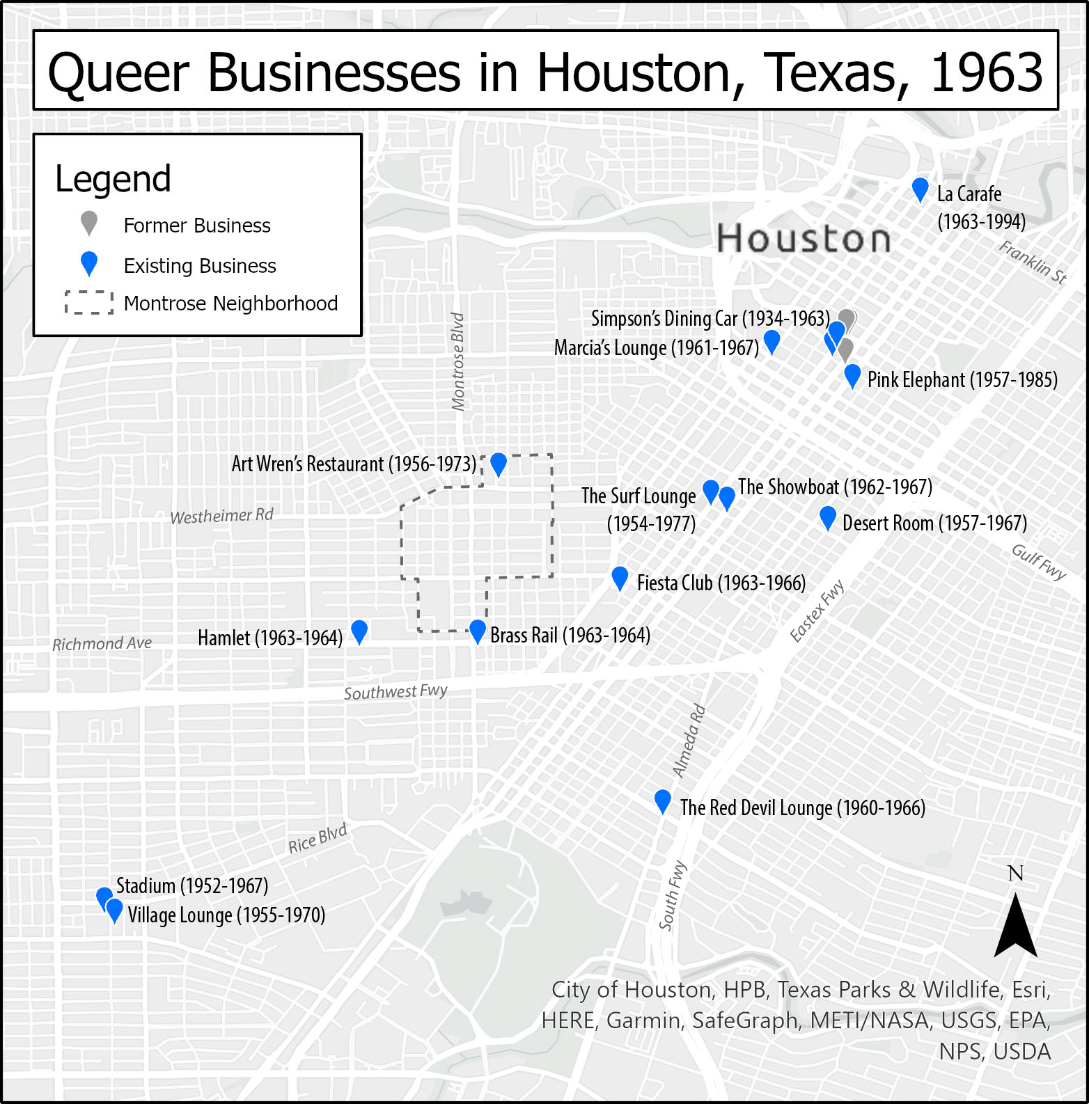
The letter also captured the writer's sense that, for its size, queer Houston was not so out of step with the larger cities of the "North and West." New York, Chicago, San Francisco, and perhaps Los Angeles were his likely referents. Given the date of his letter and his description of a recently opened and wildly popular bar, it is also likely that his referent was Bob Eddy's Showboat, opened in 1962 on Tuam Street in present-day Midtown (labeled on the map above). For the writer, cruising was a primary if ambivalent index for whether "gay life" was "concentrated" in a particular location. The "cheap" theater he referenced is challenging to specify today given the lack of detail. I have yet to find an advertisement or mention of such a downtown theater in the queer press archive of the time; perhaps its rough trade reputation circulated only through hearsay. Whatever theater it was, the letter clearly shows that as late as 1963, this author's imagination of queer space in Houston was explicitly linked to present day downtown and Midtown. Montrose did not figure in his letter at all, even though Art Wren's had operated there for about seven years and had in 1962 already appeared in a local publication in California.
Another key index for the writer's imagination of gay life comes in the phrase "rough trade," a term still in use today. Then and now, the "rough" of "rough trade" signals men whose affect and physical appearance are both more working-class and more masculine—men who are not just "straight" acting and appearing, but who also might actually be more dangerous to approach, though that risk might itself be part of the thrill of approaching them. "Trade" signals that these men may, in fact, see themselves as straight, and that they could be only "dabbling" in same-sex activity. It also signals that these men might be seeking male clients in exchange for money, regardless of their or their client's sexual preferences. The writer to ONE gestured to this sexual ambiguity of "rough trade" when he divorced the downtown scene from what he called "gay life." At the same time, we might wonder how the writer himself was aware of the theater scene. He may have participated in it, at least enough to know just how abundant and frank the rough trade was. In any event, he does not disclose how he came to have that knowledge, even in the pages of a homophile magazine.
Importantly, the writer is also silent on the subject of race, a silence that suggests Jim Crow culture continued to texture both "gay life" and "rough trade" in the 1960s just as it had "window shopping" in the 1930s. At the same time, respectability politics are both explicit and implicit in his "aloof" observations. He marks the scene around the newly opened bar with cars "parked for blocks" and patrons who presumably have disposable income to spend at a bar, all signs pointing toward respectable middle-class status. By contrast, the "rough trade" scene at the "cheap" theater points to lowbrow entertainment and potentially sex work; their "amazing quantity and frankness" also signals their divergence from middle-class respectability.
1965: The "Phantoms" of Avondale
By 1965, however, Houston's locally produced queer press offers suggestive evidence that cruising areas had begun to shift into the Montrose neighborhood. One such piece ran in the first issue (1965) of the short-lived gay periodical, The Albatross.31"Who Are the 'Phantoms' of Avondale?" The Albatross, August 18, 1965, 1. All seven issues of The Albatross were published between 1965 and 1968 in Houston by Bob Eddy, the first owner of the Showboat bar.
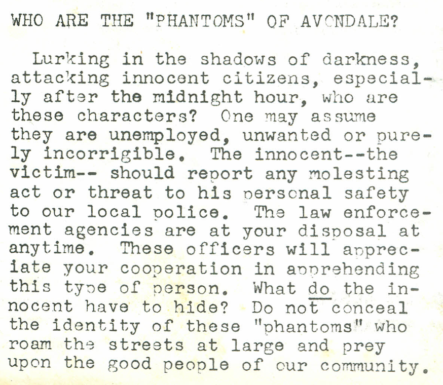
The text is an intriguing window to the mise en scène of Montrose at the time. It appeared on the first page of The Albatross, marking the editors' sense of its importance with that placement. The text calls its readers to act, to report to the police crimes that the text assumes go unreported because the victims feared approaching the police. This attitude was reflected earlier in the ONE letter writer's description of police watching carefully as the bars closed. The Albatross' text specifies the location of attacks to Avondale, a subdivision adjacent to the Montrose Addition, centered on Avondale Street along the north side of Lower Westheimer. This neighborhood identity endures today in the Avondale Civic Association.32"Avondale," Avondale Association, accessed December 31, 2019, http://www.avondaleassociation.org/. The text also specifies a time: past midnight. It thus suggests a picture of who a typical victim might be: a male ("his personal safety" was at stake) walking or perhaps driving in a neighborhood after midnight, who might in fact be able to identify his assailant ("do not conceal the identity of these 'phantoms'") but feared to do so. Race remains stubbornly absent in this narrative, even as the text specifically marks class and criminality in the figure of "good people" who should not fear reporting to the police if they are attacked by the "unemployed, unwanted or purely incorrigible." While the article did not name the practice explicitly, cruising offers explanations for both that fear and why men might be walking or driving in the neighborhood late at night. Even if cruising was not the text's primary concern, the location it describes remains telling. Avondale offered a corridor between the 24-hour restaurant Art Wren's on Westheimer and the bars of Midtown to the east.
By 1965, three bars had also opened near the Avondale area: Numbers on California, the 900 Club on Lovett Boulevard, and the Round Table on Westheimer. Business owners and newspaper editors whose livelihoods depended on steady commerce likely also understood that the safety of their customers ("the good people of our community") was a prerequisite for their reliable patronage: all the more incentive for Bob Eddy—owner of Houston's Showboat and editor of The Albatross— to launch his paper with the "phantoms" as front-page news.
1970–1972: "Risky Crusing" and "The Heat"
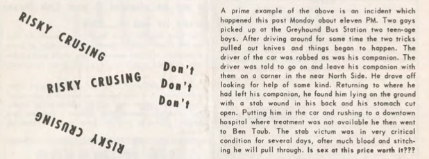
While The Albatross' article was circumspect or perhaps even purposefully vague, five years later The Nuntius33"The Nuntius & Our Community," Houston LGBT History, accessed October 1, 2020, http://www.houstonlgbthistory.org/nuntius.html. The Nuntius was published in Houston from 1970 to 1976. would explicitly center dangerous activities in the title of an article: "Risky Crusing, Don't" [sic].34"Risky Crusing, Don't," The Nuntius 1, no. 20 (August 1970): 12. http://www.houstonlgbthistory.org/Houston80s/Assorted%20Pubs/Nuntius/nuntius-1-2-8-70.pdf. Interestingly, the nonstandard spelling of cruising as "crusing" is consistent in this article; this essay honors that spelling as an historical artifact. The article references areas from Memorial Park to Midtown and the dangers such places offered would-be pleasure seekers. It cheekily opens with a reminder that cruising could "furnish you with a free ride downtown, cost you money, embarrassment and perhaps a great deal of time away from home." The "free ride" at stake here was likely to a police station, but perhaps also to a hospital. The article closes more seriously with the tale of one man who ended up at the Texas Medical Center's Ben Taub General Hospital35Ben Taub General Hospital opened in 1963 in the Texas Medical Center and is named after the Jewish businessman and philanthropist, Ben Taub (1889–1982) who never married. after being stabbed multiple times. It ends with the question: "Is sex at this price worth it?" Despite the core message to avoid danger, the article's geographical details simultaneously functioned as a guidebook. The description of Montrose even plotted a list of specific streets (see map below for an illustration of the "round-robin"):
The round-robin at Lovett Boulevard, Roseland, Hawthorne, Stratford, California, Avondale—well, you know the area better than I. This is not risky but just dangerous as h—. There have been many, many crusy [sic] queens beaten, stabbed, robbed and almost killed from picking up tricks in this area. This bad news area is a definite "No-No."
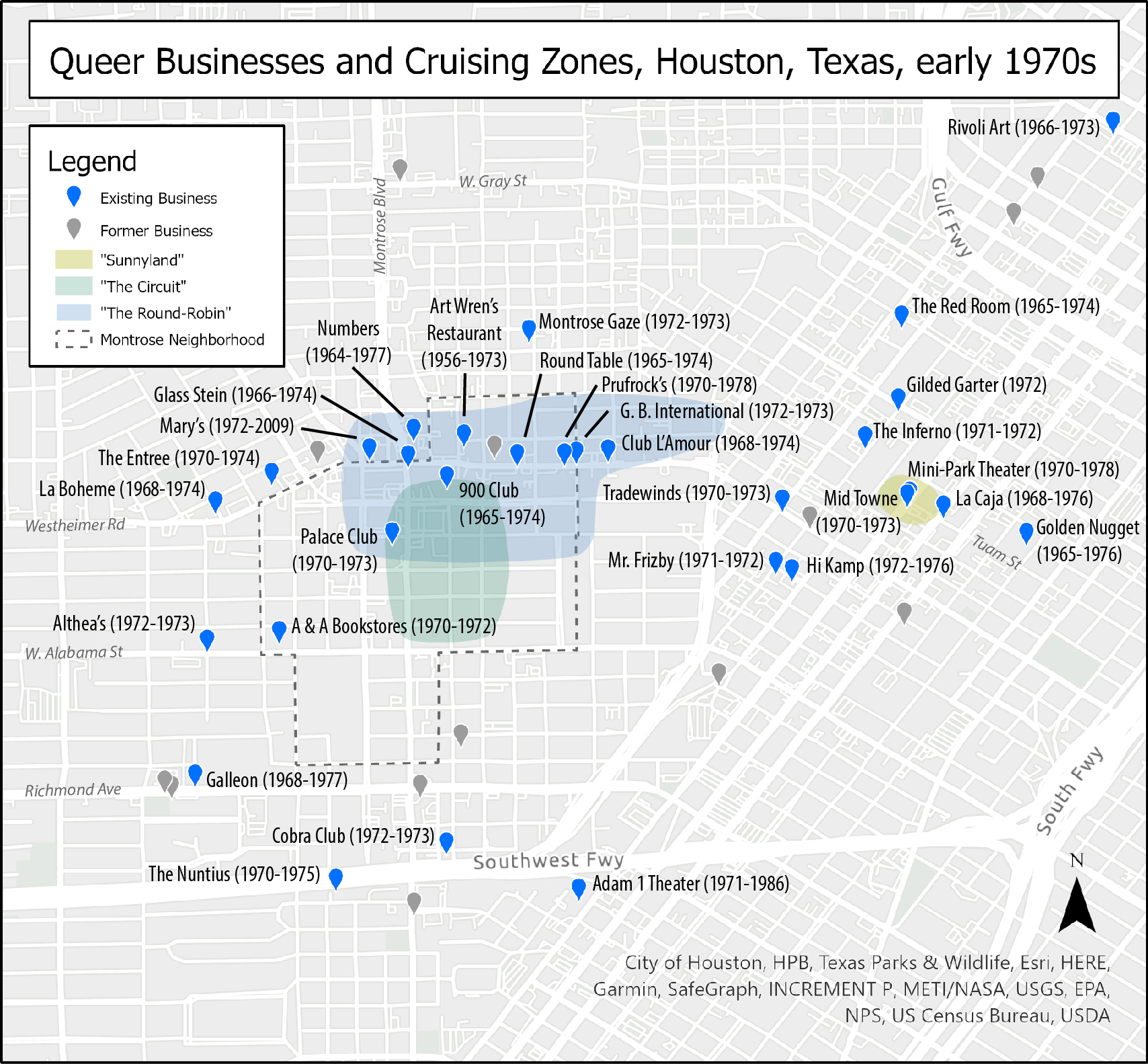
Midtown received an equal measure of detail, including specific landmarks like "Sunnyland Furniture" at Main and Tuam (also illustrated in the map above).36Suniland Furniture was located at 2817 Main Street. See a discussion thread on the Houston Architecture Information Forum, accessed December 31, 2019, http://www.houstonarchitecture.com/haif/topic/26168-suniland-furniture-building-2817-main-st/. But it is not as if these locations were entirely accidental. By 1970, the Montrose "round-robin" encircled a collection of eight queer establishments, with Art Wren's at the center. In Midtown, the intersection of Main and Tuam was also quite close to a number of other venues catering to queer community. The mapping project documented three queer businesses that operated in the 2900 block of Main—The Surf Lounge and two Nuntius advertisers, The Midtown Lounge and the Mini-Park Theater. A block away on Tuam was the successor to the Showboat, La Caja (also a Nuntius advertiser). A few blocks further was the Gold Room, a bar whose majority Black clientele likely inspired the tag line for its advertisement in the same issue of The Nuntius: "Where the Dark & Light Meet."37Gold Room advertisement, The Nuntius 1, no. 2 (August 1970): 7. Cruising was certainly one reason why some queer people went to these parts of town, but it was not the only reason. Moreover, the concentration of queer businesses and the visibility of queer people on the street did not guarantee safety for queer people in these areas, whether that danger came from police, thieves, or tricks gone wrong.38I am grateful to a peer reviewer who suggested comparing crime rates in known cruising areas against crime rates elsewhere in Houston; that work remains a compelling future area for research.
Not all welcomed cruising in public. In early 1972, The Nuntius ran a short article, "Heat on the Circuit," several pages in that describes how "the Houston Police have been making every effort to curb the crusing [sic] in the areas of Lovett, Roseland, and Marshall Streets" (labeled as "The Circuit" in the map above).39"Heat on the Circuit," The Nuntius 3, no. 1 (January 1972): 15, http://www.houstonlgbthistory.org/Houston80s/Assorted%20Pubs/Nuntius/nuntius-3-1-72-ocr.pdf. While the title and opening lines suggest the police (the "heat") should be the readers' main subject of concern, the article gestures toward the residents, "disturbed because of the heavy auto and pedestrian traffic during the late hours at night." The language to describe police efforts to "curb" cruising also suggests its readers might still have had an ambivalent relationship to the police. The article is also a form of soft control; it notified readers that officers were active in the cruising area and those cruising may wish to avoid encountering them. At the same time, the text describes the officers as "very cordial in the stopping and questioning of unauthorized persons frequenting this section." The police forces depicted here show at least a surface of courteous concern. Those with a legitimate (respectable) reason to frequent the area need not fear, but passers-through might still doubt who the final arbiters of that legitimacy would be. Presumably, the "unauthorized" could include both the cruising "hungry hannas" and criminals who prey on them, but we cannot assume that Montrose residents, their visitors, business owners, and bar customers themselves never cruised the streets where they lived, worked, and played. The Nuntius' depiction of the neighborhood shows several subtle but important shifts from the arrangement of queer community and police that marked the Albatross' item on the "'Phantoms' of Avondale." By 1972, queer pedestrians and drivers had become more visible, perhaps even emboldened in a post-Stonewall era, but were still at risk from both criminals and the police. Officers for their part had also become more vigilant. While queer people clearly remained subjects of potential police control, it appears that some were slightly more likely to see themselves as subjects of potential police protection, at least those queers who might be "authorized" to be walking or driving around Montrose as respectable residents, guests, or consumers.
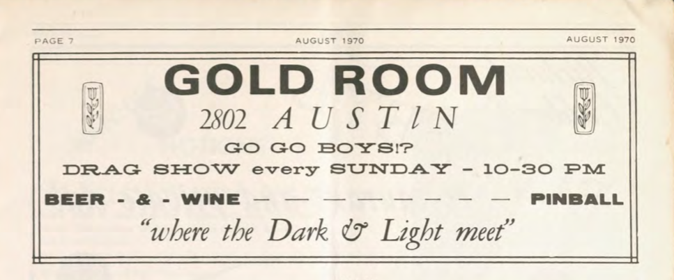
These two articles from 1970 and 1972 also continue the trend of prior cruising narratives; neither mentions race in any explicit way. That absence of racial awareness reflects the dominance of white narratives in Houston's queer press at the time, but is also a curious elision given the rising visibility of Houston's Black queer life both locally and nationally. Beyond the Gold Room's advertisements in The Nuntius, the 1971 Damron Guide also coded the Gold Room as a very popular Black bar.40"Texas Bars, Baths, Etc.: From Bob Damron's Address Book 1971," Houston LGBT History, accessed October 1, 2020: 112, http://www.houstonlgbthistory.org/houston68-71.html. More curious still is that The Nuntius ran multiple stories in 1971 about the Houston Gay Liberation Front picketing the Red Room (see map above for location) because it did not admit Black patrons. Even as activists were calling attention to the segregation of queer spaces in Houston, these two narratives of cruising could omit explicit discussion of race in a multiracial city.
1971: "Come and Browse, or Vice Versa"
Evidence of cruising also appears beyond documents generated specifically by and for queer communities. For example, Mayor Louie Welch's records41Louie Welch Collection, MSS 51, Houston Metropolitan Research Center, Houston, Texas. To be clear about my archival process and research methodology, I did not know at first that Welch's papers held citizens' complaints and police records that would matter to documenting histories of cruising or of Montrose. I came across these records quite by accident while looking to substantiate historian James Sears' assertion that Welch and gay bar-owner George Hauger knew each other. I have yet to find any evidence to prove or disprove the assertion. See James Thomas Sears, Rebels, Rubyfruit, and Rhinestones: Queering Space in the Stonewall South, (New Brunswick, NJ: Rutgers University Press, 2001): 55. preserve a host of documents reflecting political and social currents that converged to regulate cruising. Of particular interest for this essay are citizens' complaints urging local authorities to shut down sexually-oriented businesses like video arcades that would "degenerate" their neighborhoods. That records of these complaints survive today, specifically in Mayor Welch's archive, attests to the power of the social and political forces converging on cruising at the time. Some citizens believed the authorities could and should address the issue, while for their part, the Mayor and other local authorities evidently deemed cruising important enough to track and combat.
Though locally produced, these citizen complaints also stand in complex relationships with national anti-pornography campaigns, religious organizations, and conservative political movements, as analysts like Whitney Strub have argued.42Whitney Strub, Perversion for Profit: The Politics of Pornography and the Rise of the New Right (New York: Columbia University Press, 2011). In the case of Houston, some complaints to the Mayor were clearly driven by national mailing campaigns from organizations like Charles Keating's long-running Citizens for Decent Literature (CDL). Sometimes, these campaigns arrived in the mailboxes of people already deeply engaged, for whom CDL mailings were both affirmations of and ammunition for their existing efforts. When these local complaints target businesses serving a queer clientele, national anti-pornography campaigns enter into a network of converging effects in which battles to define urban space result in the arrests of both consumers of queer pornography and patrons using those video arcades to cruise in semi-private and presumably safer, commercial spaces.
The Police Complaints and Criminal Intelligence Report folders in Welch's papers reveal a chain of communications among the public, the Mayor's Office, and Chief of Police Herman Short. Those communications in turn generated specific police activities directly affecting queer lives. These records show not only that Chief Short's police department was to varying degrees responsive to Houstonians' complaints of perverse activity in their city, but also that it proactively engaged in intelligence gathering to infiltrate and map the social networks they saw as driving both perversion and social instability. The Criminal Intelligence reports track investigations into presumed weapons dealing by Black militants and meetings of leftist groups like the Socialist Workers Party43The Socialist Workers Party is a communist organization in the United States that traces its roots to 1928. In Houston, Texas, the SWP acted in coalition with other organizations on the left, including the Gay Liberation Front. and the Mexican American Youth Organization.44The Mexican American Youth Organization formed in San Antonio, Texas in 1967, and was regarded as a militant form of Chicano activism, especially relative to mainstream organizations like League of United Latin American Citizens. In Houston, MAYO had strong ties to the University of Houston campus, much like the Gay Liberation Front Houston. They also track claims of reciprocal arson among rival gay bar owners, intimidation tactics among national pornography distributors vying for control of the Houston market, and individual members of Houston's nascent Gay Liberation Front.45The Gay Liberation Front formed in New York shortly after the Stonewall riots of 1969, and quickly spread to Canada and the United Kingdom. Though it would frequently collaborate with other left organizations, it was short lived; other lesbian and gay organizations had largely supplanted it by the mid-1970s. In Houston, a branch of GLF formed in the Montrose neighborhood in September 1970 and organized a student group at the University of Houston.
To offer one example in which citizens' complaints of cruising converged with local police priorities and national anti-pornography campaigns, consider the correspondence between the office of the Mayor and a Montrose resident named R. L. Martinson.46Reproducing Martinson's real name is a considered choice. Primarily, he made himself a subject of public record by sustained communication with public officials. Also, unlike the letter writers in Craig Loftin's compilation, his actions at the time would not be interpreted as criminal, regardless of how we today might ethically evaluate those actions. Martinson took several opportunities to urge the city to prevent what he saw as the decay of Montrose. In a letter dated October 29, 1971,47Correspondence from R. L. Martinson to Mayor Louie Welch, 29 October 1971, MSS 51, Box 30, Folder 2, Louie Welch Collection. Martinson reminded the Mayor of a letter from some months before in which he had asked for help "to rid this and other neighborhoods of the filthy atmosphere of the adult book store and lewd movies." While his complaint might at first be taken as a generic complaint about pornography, he then specifically mentions the return of an adult bookstore ("Story Book") at the former location of the "Adult Library and Mini-Theater" at 1323 West Alabama, an advertiser in The Nuntius (though at the slightly different address of 1312 West Alabama; see map above). The location for both operations was only one block from Martinson's residence, today just north of St. Thomas University and west of the Annunciation Orthodox Church.
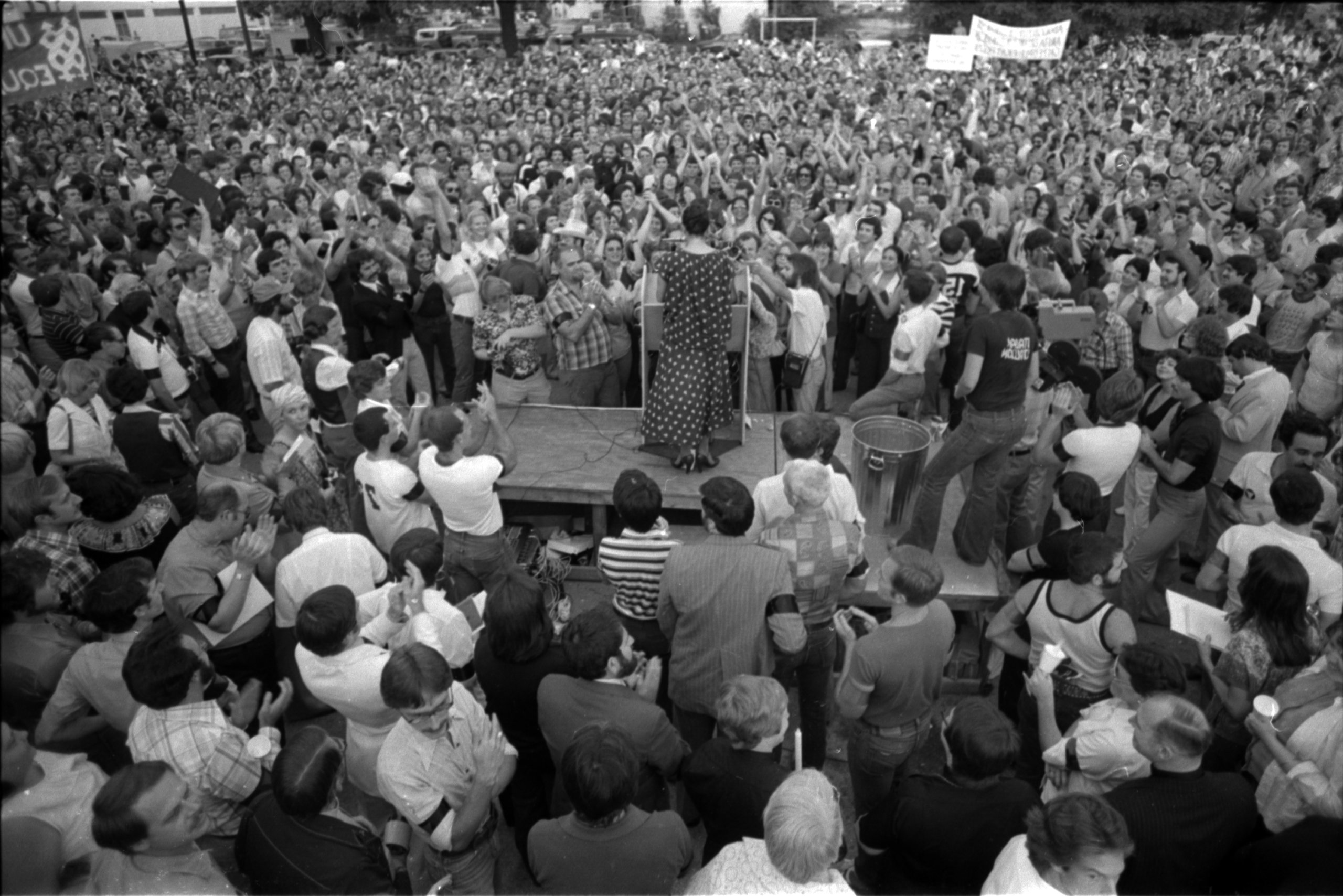
In an all too familiar rhetorical move foreshadowing Anita Bryant's 1977 "Save Our Children" campaign, Martinson focused on protecting "youngsters" from the "crowd of homosexuals and perverts who roam the neighborhood night and day." Whether or not Martinson's "roaming" is the same distinctively spelled "crusing" that The Nuntius warned its readers against, the situation apparently had been sustained for some time, as Martinson writes that he and his neighbors "have suffered enough in the past two years." Indeed, queer newspaper advertising indicates that the Adult Library first opened on Alabama in 1970.48The Houston City Directory intriguingly shows that, immediately prior, the location was occupied by "Miss Adorable Wigs." As a 24-hour venue advertising with the tag line "Come and Browse, or 'Vice-Versa,'" the Adult Library would indeed have attracted the kind of cruising traffic Martinson's "roaming" describes. The "Vice-Versa" also underscores how unlikely it was that customers came to the store just to browse. Presumably, most would browse the movies and the clientele on offer in the relative privacy of the store's video arcade. Perhaps they would select one or more sex partners—especially if the viewing booth they chose offered openings into other booths. In all likelihood, given the purpose of such arcades and the business's tagline, many would also come before they left, whether or not this occurred with a partner.
Martinson's letters also demonstrate his willingness to argue that the laws supported his position and would empower city authorities to act accordingly, though his own narrative is vague about precisely which laws might actually have done so. His October 1971 letter refers simply to "a new law which apparently went into effect September 1." Martinson clearly assumed this law somehow led to the closure of the Adult Library. More specifically, in another letter to the Mayor dated February 12, 1972,49Correspondence from R. L. Martinson to Mayor Louie Welch, 12 February 1972, MSS 51, Box 30, Folder 4, Louie Welch Collection. he writes that "sodomy charges" were at stake. At the time, Texas and most other states did indeed have sodomy laws on their books; in 1972, the Texas statute also included heterosexual non-reproductive acts but would be refined in 1973 to apply only to same-sex acts. However, there was no 1971 adjustment to the Texas penal code and the various sex crime laws described in its Chapter 21. As Texas House Speaker Gus Mutscher lamented of the 62nd session: "The much-discussed penal code reform was the second failure in 'must' legislation for the session. The state bar-recommended revision as presented in HB 419, proved to be controversial enough that sponsors said they would delay action another two years."50Gus Mutscher, "Accomplishments of the 62nd Legislature," 1972, 9. Accessed June 24, 2020. https://lrl.texas.gov/scanned/SessionOverviews/62_Accomplishments_1.pdf.
Beyond Martinson's legal theories and emotions about the reopening of the adult business, his October 1971 letter is remarkable for the social imagination driving his proposed solution: "Let's put these dens of pervertion [sic] in an isolated part of town, if we must have them, and not allow them in residential areas or shopping centers to tempt our youth."51Martinson to Mayor Welch, 29 October 1971. Despite witnessing two years of night and day homosexual presence, Martinson apparently could not imagine even in late 1971 that his neighborhood might already be that part of town. Perhaps his concern was that it would soon become so in the absence of his complaints.
The official acknowledgement of his October letter was swift, even if action was not. The Mayor's office marked it to forward to Chief Short, and sent a brief note to Martinson dated November 3, 1971.52Correspondence from the Office of Mayor Louie Welch to R. L. Martinson, 3 November 1971, MSS 51, Box 30, Folder 2, Louie Welch Collection. Despite that note's assurance that Chief Short would investigate and be in touch in the near future, it appears Martinson did not receive any of the promised updates. In his letter of February 12, 1972, his tone shifts toward impatience as he writes "once more" to "inquire what, if anything is being done about places such as the 'so called' Story Book at 1323 West Alabama."53Martinson to Mayor Welch, 12 February 1972. The invective of this letter targets "perverts" as it marks the frequent traffic of "characters" that circulate without "merchandise" at Story Book and the nearby Grass Hut, a venue other complaints mark as a "pot-parlor."54Correspondence from Coralie Anderson to Mayor Louie Welch, 28 April 1971, MSS 51, Box 29, Folder 12, Louie Welch Collection.
This February letter also surfaces a powerful converging effect: Martinson specifically refers to the January–February 1972 National Decency Reporter, a newsletter from Citizens for Decent Literature. Per Martinson, it reports "crackdowns And Convictions in Ohio, Nebraska, California, among others."55Martinson to Mayor Welch, 12 February 1972. Capitals and underscore in the original. Martinson's February letter received a similarly swift acknowledgement from the Mayor's office, dated February 17, once again noting that the complaint had been forwarded to Chief Short, but this time without any promises of further communication.56Correspondence from the Office of Mayor Louie Welch to R. L. Martinson, 17 February 1972, MSS 51, Box 30, Folder 4, Louie Welch Collection.
Although Martinson may not initially have received the degree of response he sought, action was eventually forthcoming. An internal police memo dated March 21, 197257Internal police memo from Sergeant T. R. Driskell to Lieutenant J. M. Albright, 21 March 1972, MSS 51, Box 30, Folder 4, Louie Welch Collection. went from Sergeant T. R. Driskell of the Vice Division up the chain of command via Lieutenant J. M. Albright to Chief Short, and from him to the Mayor, per a March 22 memo from Chief Short.58Internal memo from Police Chief Herman Short to Mayor Louie Welch, 22 March 1972, MSS 51, Box 30, Folder 4, Louie Welch Collection. The details of Driskell's memo illustrate how Houston police officers enacted the laws available to them as they understood them, while the chain of communication itself shows how closely the Mayor personally monitored police actions regarding the gay community. Driskell reported on the status of the state sales license, which cleared their check. Eight mini-movie machines were noted in the rear of the bookstore. Police surveillance further "revealed" that "homosexuals frequent this place,"59Driskell to Albright, 21 March 1972. although it is unclear precisely what techniques of surveillance and evidence substantiated that claim. It is clear, however, that on March 8, 1972, five patrons were arrested and charged with committing an "Indecent Act" under the then-operative Chapter 21 of the Texas Penal Code. "The manager was not arrested" as "he was not involved."60For those who have ever visited adult bookstores with video arcades, this exclusion might not surprise: a manager is usually up at the front, selling access to the movie and cruising area at the back. That said, I am also grateful for a reminder from an anonymous peer reviewer that "owners of bath houses, bars, or cinemas sometimes faced police crackdowns in other cities, even if they didn't engage in sex themselves." The impact of these converging effects on the Story Book was much broader than this one raid, however. Driskell notes that since July 29, 1971, "there has been a total of 27 arrests for various offenses" at this location. He also reports "we are in the process of trying to get an injunction through Civil Court and have this place closed."
Perhaps unsurprisingly, none of Martinson's letters or the police memos explicitly mention race.
1974: "Rough Trade"
While Houston-based and locally-distributed publications like The Albatross and The Nuntius range from elliptical descriptions of cruising to explicit cautionary tales, Ralph W. Davis's richly photographed December 1974 article about Houston in the nationally-distributed gay travel magazine Ciao! verges on the celebratory.61Ralph W. Davis. "Houston," Ciao!: the World of Gay Travel. December 1974, 10–13; available also via the JD Doyle Archives: http://www.houstonlgbthistory.org/houston74.html. Ciao! was published out of New York City from 1973 through 1980. For more about the impact of Ciao!, see Lucas Hilderbrand, "A Suitcase Full of Vaseline, or Travels in the 1970s Gay World," Journal of the History of Sexuality 22, no. 3, (2013): 373–402. Indeed, "Cruise Areas" constitutes the first major subsection of his four-page article. He rehearses several areas mentioned in prior publications, beginning with the following bolded statement: "The main cruise area is Roseland to Hawthorn to Lovett to Stanford. Lovett and Stanford, and Lovett and Montrose are good corners to linger on at night." After directing readers first to a part of Montrose only five blocks from R. L. Martinson's home, Davis then helpfully notes, "Lovett and Stanford is a little darker than the latter, and some may prefer this for obvious reasons." Those "obvious reasons" would likely include the cover that darkness can provide for either a quick outdoor sex scene or an increased degree of camouflage and anonymity for the long term lingering sometimes required to pick up a trick worth taking elsewhere.
For Davis, not all cruising areas come equally recommended. He specifically evaluates them in terms of their "roughness," with all the gender and class markers animating the 1963 letter to ONE. The cruise area section of Davis' article continues the pattern of past cruising narratives and gives no guidance about the racial mix of men frequenting any specific area. However, the individual bar listings within the article do occasionally reference race and nationality. The clientele of the country/western Golden Spur "includes some tough Latins and blacks"; the Gold Room gets a nod toward the end of the article as "an old established black bar"; the Athens Grill and Bar on the Houston Ship Channel is recommended as "the place to go for Greek sailors who, when a little drunk, swing either way," a variation on the theme of rough trade. None of these three bars are close to any of the cruise areas Davis names, however.
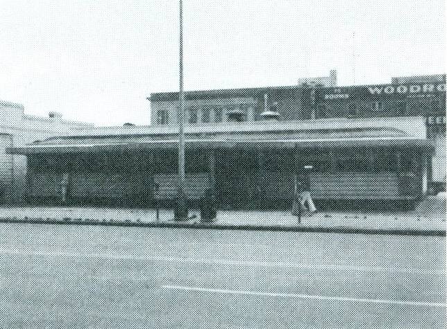
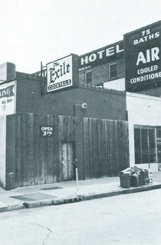
Of those cruise areas, Davis found the roughest one to be the Midtown corner of Bell and Main that hosts Simpson's Dining Car, the Exile Lounge, and, though he does not mention it in writing, the Woodrow Hotel. One hint toward the hotel's role comes when Davis notes "[o]nce Simpson's was a 24-hour restaurant; now it closes at 1 a.m. to avoid serving some of the hustlers and roughs who settle almost all night on the corner of Main and Bell." On the last page of the article, he also describes the Exile as "probably the most recommended of the rough bars."
To complete the implication, an examination of two accompanying photographs of Simpson's Dining Car and the Exile Lounge reveals the Woodrow Hotel looming in the background of both, boldly advertising "75 Rooms," "75 Baths" and "Air Conditioning" on the wall facing Main Street. Industrious Ciao! readers would also have seen that the Damron Guides for 1971 and 1972 also list the Woodrow Hotel.
For hustlers cruising for a living, that single block provided a ready-to-hand circuit of the necessities: food, drink, a steady stream of potential customers, and a private room and bath when it came to business. For out-of-town and local johns looking for the right place to go, Ciao! pointed the way. At Main and Bell, cruising and commerce commingled in a much more intense and intentional way than the Story Book on Alabama.
1976: No Turns
Although the 1972 Nuntius article gives the impression that residents played a minor role—at most complaining to the police who then in turn engage the "unauthorized"—residents do become more organized and vocal agents over time. In September 1975, Virginia Galloway reported in Update Texas that residents had formed the Montrose Citizens Association (MCA).62Virginia Galloway, "Montrose Circuit," Update Texas, Sept 26–Oct 3, 1975, 2. While the organization's name suggests an expansive membership, details on it are scarce; organizational records point only to the name of a lawyer in Montrose: Richard L. Petronella.63Initial research about the MCA surfaced a helpful clue for further work, although the source for that clue is suspicious. See "Montrose Citizens Association Inc." Bizapedia, accessed December 31, 2019, http://www.bizapedia.com/tx/MONTROSE-CITIZENS-ASSOCIATION-INC.html. That website provided the following data: "Montrose Citizens Association Inc. is a Texas Corporation filed on September 2, 1975. The company's filing status is listed as Franchise Tax Involuntarily Ended and its File Number is 0036646201. The Registered Agent on file for this company is Richard L Petronella and is located at 815 Hawthorne, Houston, TX . The company's principal address is 815 Hawthorne St Richard Petronella, Houston, TX 77006-3901." The Association's remarkable strategy eerily echoed R. L. Martinson's proposal to Mayor Welch: relocate the Circuit. Galloway reported that "area gay organizations" collaborated with the MCA to pass out flyers at street corners in the Montrose Circuit on Friday and Saturday nights, informing potential cruisers of the "moving of the historic cruising area" from Montrose to a "non-residential, semi-isolated area nearer downtown" that would supposedly be "more conducive to cruising conditions, since the roads are better and there is good lighting." The flyer included a map of the new location and described the reasons for the move: "an effort to cooperate with neighborhood residents, who are finding the activity on the Circuit increasingly more difficult to live with because of the noise and traffic in the early morning hours." Supposedly, an impending police crackdown could be avoided if the cruisers were to voluntarily relocate. Galloway's reporting gestured quietly to the odd optimism of the scheme: "most were eager to hear of the new area, although actual response by moving is still slight." Houston cruisers in 1975 might have also remembered Ralph Davis' Ciao! article recommending a specific intersection in Montrose as darker than others. "Good lighting" was a curious way to pitch a new cruising ground to that market.
Such tactics aside, MCA's flyer campaign clearly required significant planning and volunteer effort, from designing and printing the flyers to the volunteer time of handing them out at multiple intersections on multiple nights. Although attorney Petronella is the sole name listed on the organization record, clearly he was not acting as a lone agent. Other community organizations were involved, perhaps even the Houston Police Department, especially if the new location for the Circuit would not also be subject to a police crackdown. Presumably, MCA also checked with the residents and business owners in the proposed new location to be sure cruising would not present a problem to them as well.
However, the Montrose Circuit's decade-long reputation as a cruising ground proved harder to break than the MCA campaign at first envisioned. Just a few months later, in March 1976, Mel Plummer (former owner of Update Texas) wrote a column for The Nuntius titled "Houston Cruise Circuit Closed," in which he argues that the flyer campaign failed because the roads at the new location could not handle the volume of car traffic, particularly during the peak weekend hours for the nearby Farmhouse, a three-story gay bar on Albany.64Mel Plummer, "Houston Cruise Circuit Closed," The Nuntius (March 1976): 3. http://www.houstonlgbthistory.org/Houston80s/Assorted%20Pubs/Nuntius2/Nuntius%20SW-031276.pdf. This article repeats and extends a story of the same name run in the previous February issue. See The Nuntius (February 1976): 2. http://www.houstonlgbthistory.org/Houston80s/Assorted%20Pubs/Nuntius2/Nuntius%20SW-020676.pdf. He places responsibility for this failing on MCA for choosing the relocation area on its own, rather than consulting first with "those involved with the Montrose circuit." Plummer's reporting also answered a curious gap in Galloway's account: he specified the gay organizations working with MCA as the Gay Political Caucus, the Metropolitan Community Church, and "other local organizations"—some of whom could also have offered expert guidance on the move. With the failure of the flyer campaign, Plummer reports that MCA escalated its efforts and barricaded the roads one night, purportedly with collaboration from the office of Mayor Fred Hofheinz. Plummer also casts doubt on that last claim, noting that the City had issued no permits and the police did not supervise the barricades. The barricades were not MCA's final option, however. The Association apparently described this new tactic as "their last stand before police harassment would begin to all those who frequented the infamous 'Montrose Circuit.'"65Ibid. The cordiality evoked in the 1972 The Nuntius article had evaporated.
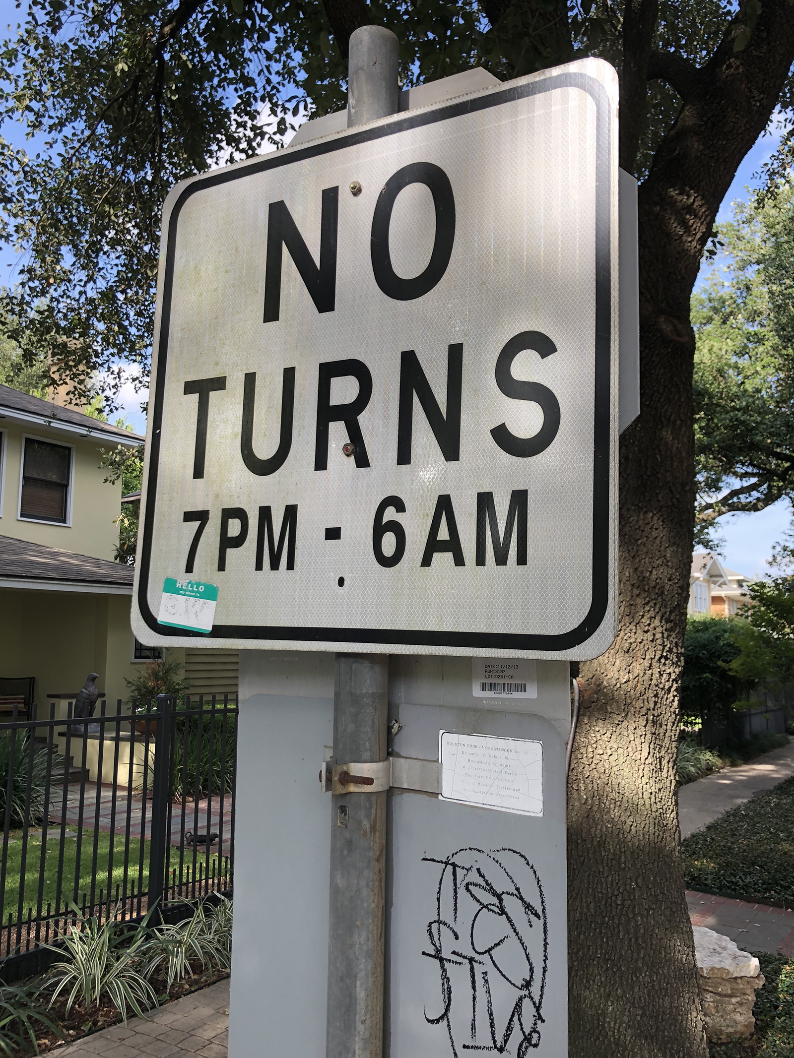
MCA unleashed that final option on Wednesday, January 28, 1976.66Plummer's article reads "January 26," an apparent editing error. With the evident cooperation of the City of Houston, MCA installed signs prohibiting vehicles from making turns between 7 p.m. and 6 a.m. in the Montrose area. These no-turn signs restricted those cruising by car from circling legally through the side streets of the neighborhood, breaking the social pattern connecting cruisers on foot with cruisers in cars. Indeed, Plummer reports that the next night "Houston Police issued 43 traffic citations for illegal turns and five people were taken to jail. This has all but assured that the Montrose Circuit exists no more."67Ibid. Importantly, this "death" of the circuit also became mainstream news; Houston television stations picked up the story with what Plummer describes as "fair and unbiased reporting." To be sure, the crackdown on cruising in Montrose did not spell the death of cruising itself. Even as Plummer asserts that "most Gays have not found a new cruise route," he goes on to observe that "many are returning to the old cruise route before the days of Montrose. This was known to many as Suniland. The area consists of the streets Main, Tuam, Fannin, and Anita."68Ibid. Indeed, these are the very same streets The Nuntius readers might remember as too risky, as places where pleasure mingles with danger. One implication of this strange return is that the shifting of neighborhoods and cruising areas is not uniform, unidirectional, or irreversible.
It is also important for us today to recall that queer folk were not always victims but also sometimes the perpetrators of surveillance and violent crime in 1970s Houston. Such crimes may also have influenced those seeking to shut down or relocate cruising areas. Many of these crimes are all but forgotten. For example, The Nuntius ran a 1971 story about a teenage boy who was picked up by two men in downtown Houston and taken back to their residence in Montrose, "known to the most of us as 'the colony.'"69"Halloween Horror for 16 Year Old Boy," The Nuntius 2, no. 11 (November 1971): 1. http://www.houstonlgbthistory.org/Houston80s/Assorted%20Pubs/Nuntius/nuntius-2-6-11-71.pdf. After what initially seemed to be an evening of drinks and movies, the boy "stated that he was knocked in the head by one of the men and tied up, beaten with a rubber hose and sexually assaulted by the pair."
Other crimes catapulted into the national consciousness. As Montrose residents and cruising men were engaged in their turf wars, Dean Arnold Corll had already begun what would come to be known as the Houston Mass Murders or the Candy Man Murders, in a gruesome nod to Corll's family business. Between 1970 and 1973, he and his accomplices are believed to have abducted, sexually tortured, and killed at least 28 teenage boys. While most of these boys had deep connections to or were taken in the Houston Heights area, the symbolic impact of the murders extended to all of queer Houston when the case was finally exposed in 1973 after one of Corll's accomplices murdered him. At the time, it was the worst serial murder case in United States history. The denouement of the Candy Man Murders played out the same year the American Psychological Association removed its classification of homosexuality as a mental illness in the Diagnostic and Statistical Manual.
More intriguingly still, even as the Montrose Citizens' Association began its 1975 flyer campaign, the Houston Chronicle began reporting on a string of murders in Montrose, mostly of men, many of them graphically violent. Then the Chronicle's January 8, 1976 front page ran the headline "Homosexual Tells Police He Killed 3 Men Here." The first line of that story described the confessor, Joseph Standwick, as "an admitted homosexual."70"Homosexual Tells Police He Killed 3 Men Here" Houston Chronicle, January 8, 1976, Sec. 1, 1. Later coverage would add to that description: "admitted homosexual and male prostitute."71"Homosexual Suspect in 3 Slayings Questioned by Arson Investigators," Houston Chronicle, January 9, 1976, Sec. 1, 12. Such headlines and biased language deepen our understanding of why Plummer might specifically comment on the "fair and unbiased reporting" regarding the no-turn signs and cruising; just weeks before the no-turn signs went up, many Houstonians were imagining a murderous, gay prostitute in Montrose.
In that context, battles over whether gay men could or should claim Montrose as their cruising grounds have an understandable urgency, and not just for cruising men concerned about their own safety. As Ralph Davis wrote in Ciao! in 1974, "[t]he Mayor, in order to reduce growing tension arising between straights and gays, immediately advised bar owners that he would not interfere with business so long as their patrons weren't a public nuisance."72Davis, "Houston," 10. Given prior police raids on the Story Book and any number of other queer establishments, cruising men might mistrust such promises. Cruising in Montrose was steeped in emotions and conflicting interests: straight-gay tensions, business concerns, residents' long-standing noise and traffic complaints, and murderous headlines (none of which ever mentioned race as a motivating factor). To be clear: no extant records indicate that the Montrose Citizens Association explicitly or implicitly connected the Candy Man and Joseph Standwick to men cruising Montrose for sex. Still, the possibility of that connection may help explain how the MCA came to have the support of the Gay Political Caucus and the Metropolitan Community Church, both organizations invested in promoting the respectability of gay people.
Time would prove the MCA's no-turn signs to be a limited success, however. A decade later, a new no-turn sign campaign launched in Montrose, and the occasion spurred many to recall the limitations of the 1976 MCA effort. Connie Woods described the new campaign in the Montrose Voice: "signs went up . . . at four intersections between Alabama and Harold at the request of the Montrose Ltd. Homeowners Association, creating controversy among residents of the neighborhood who were unaware of such requests."73Connie Woods, "New 'No Turns' Street Signs Go Up," Montrose Voice, January 24, 1986, 11. She closed the article with a brief, neutral nod to the past: "Such traffic signs were first established in the Lovett Blvd. and Stanford area on the south side of Westheimer in the 1970s to discourage 'cruising.'" The pages of This Week in Texas (TWT) offered stronger commentary, quoting Montrose resident Charlie Miller: "Responsible people will note that these signs didn't stop cruising when they were erected on the east side of Montrose Blvd. . . . The circuit merely moved, and most likely will relocate again."74"Cruise Area Under Attack," This Week in Texas 11, no. 46. (January 31–Feb 6, 1986): 19–20. http://www.houstonlgbthistory.org/Houston80s/TWT/1986/86-013186.compressed.pdf. TWT also quoted a 1985 letter from the Montrose Ltd. Homeowners Association to the city's Traffic and Engineering Department which made it clear they aimed to limit cruising:
The traffic begins increasing at dusk, is heaviest between 10 p.m. and 3 a.m. and continues until approximately dawn [… ] Most of the vehicles circle 10 or more times, but some have circled 50 or more times in one night. Depending on the day of the week, there are between 10 and 40 cars circling the block […] It's not unusual for four or more cars to be queued at each stop sign, waiting to turn the corner.
TWT readers were eager to share their thoughts in return. Bill Jackson wrote: "My apartment manager is, I believe, president of the homeowners association. I know, based on a conversation with him last fall, that they think anyone walking in the evening is soliciting, if not selling it."75Bill Jackson, "Letter to the Editor," This Week In Texas 11, no. 48 (February 14–20, 1986): 21. http://www.houstonlgbthistory.org/Houston80s/TWT/1986/86-021496.compressed.pdf. For his part, Don Buch argued that no-turn signs "demean and cheapen our Montrose properties and do not address the 'cruising' problem. It is in fact just a political tool for Houston police."76Don Buch, "Letter to the Editor," This Week In Texas 11, no. 48 (February 14–20, 1986): 23. As of this writing, some of the no-turn signs remain: two at the intersection of Marshall and Graustark, and nine along Roseland and Stanford streets. Despite consistent efforts from a variety of forces, the Montrose cruising circuits remained resilient.
Cruising Toward Theory
Taken together, these seven narratives of cruising do not describe an uncontested process of place claiming and recognition as Levine's model implies. Instead, they show territorialization through cruising to be temporally bound, conflicted, and structured in part through a politics of respectability explicitly linked to class concerns but uniformly silent on race. Considered alongside the brick-and-mortar locations of commerce and consumption that informed my earlier ArcGIS animation, these cruising narratives show that queer territories often operate on very different scales within and across multiple spaces. In these stories, the most typical scales of urban territory described are specific street corners, a few adjacent blocks, or occasional larger areas. Sometimes, but not always, these cruising grounds are connected to the commercial spaces privileged in the animation.
As the narratives attest, the practice of cruising has proponents and detractors. Tension over this practice in Houston largely stemmed from the range of agents involved and the variety of positions these agents took up on cruising. Over the years of analysis, the queer press promoted a number of stances on the behavior: discretely framed warnings, explicit admonitions that conveniently double as instruction manuals, and almost celebratory accounts of where specific kinds of action are to be found, ranked by dangers not limited to the threat of an encounter with the police. Queer and non-queer agents also intervened in a coalition to curb cruising. The Montrose Citizens Association had some degree of cooperation from the Gay Political Caucus and the Metropolitan Community Church. That alliance of respectable, community-oriented organizations built on years of residential complaints of noise and traffic even as Houstonians learned about a murderous gay prostitute in Montrose. The City of Houston directly engaged through policing, constituent messaging, and posting signage. Resilient sex-seekers responding to all of these agents seem to have found other places to pursue the chase, in part through cruising grounds remembered from other times. They had many alternatives available in collective, living memory, from cruising spots in downtown, Midtown, Montrose, Memorial Park, the Galleria, and beyond, to the adult bookstores and video arcades across the Houston landscape. At the same time, sex-seekers persisted in cruising areas like the Montrose Circuit, despite continuous efforts to displace them.
Beyond literal embodiments and emplacements, these narratives also illustrate that queer territories become so because both those who do identify as queer and those who do not identify as queer imagine them to be so. The full cast of characters holding these mental maps ranges widely in power, from unnamed neighborhood residents to the Mayor of Houston. These actors can be close to the field, like Richard L. Petronella and R. L. Martinson, and quite distant, like those reading Ralph Davis' article in the nationally circulated Ciao! magazine.77Benedict Anderson's arguments are particularly relevant here. See his Imagined Communities: Reflections on the Origin and Spread of Nationalism (New York: Verso Books, 2006). Patterns of rough trade visible since the 1960s also suggest that some men—at least those who cruise other men for sex and do not identify as queer—also carry mental maps of queer territory, if only to avoid those places lest the label stick to them.
As such, these seven cruising narratives present queer territory in Houston as a fractured and shifting network of sites imagined and contested by multiple populations, some of whom also participate in those scenes. Such an arrangement of queer territory strongly supports Ghaziani's concept of "cultural archipelagos" more than any model of a single, "gayborhood" enclave. Moreover, Gieseking's mental maps offer a well-attuned method to document the multiple social networks imagining those multiple cruising areas, at least for those living today. For the departed, the method of archival research present in works like this one will have to suffice.
These historical cruising narratives also pose several questions for future work, particularly as we explore the practice of cruising as it intersects race. Contemporary narratives like Espinoza's describe cruising as a ground on which men may meet other men of many different bodies, races, and classes. His is not a uniformly utopic stance, to be sure. He writes of people rejected for the color of their skin or the shape of their body while cruising. He acknowledges that many progressive projects, queer theory in particular, are rightly critiqued for "shutting out the lived realities of Black, Asian, Brown, and disabled queers altogether."78Espinoza, Cruising, 204. On the whole, this book leans more toward the utopia of cruising than its critique. And yet, immediately after that acknowledgement, his text embraces utopic potential: "The cruising ground erases these divisions, allowing for a more egalitarian experience not predicated on racial constructions" (Ibid., 204).
So what should we make of a body of Houston cruising narratives in which the division of race is indeed erased, so much so as to render race essentially invisible rather than seen? Perhaps it should not surprise that race goes so consistently unmarked in cruising narratives taken from Houston's white-dominated queer press. The pattern also extends nationally: as the Damron Guides began to mark race and to list cruising areas in the early 1970s, Houston's bars (the brick and mortar) were often coded for race; the archipelagic cruising areas were not. Perhaps the presumption was that, because cruising areas ranged from public outdoor space to semi-private commercial settings and were therefore "open to all," there was no reason to mention, much less mark, race. Here, oral histories with cruisers themselves would offer invaluable evidence about actual practices on the ground.79Literary accounts are also helpful, like Samuel Delaney's in Times Square Red, Times Square Blue (New York: NYU Press, 1999) or The Motion of Light in Water: Sex and Science Fiction Writing in the East Village (Minneapolis: Minnesota University Press, 2004). He was not writing of Houston however. Edmund White's States of Desire: Travels in Gay America (Madison: University of Wisconsin Press, 2014) moves through much of the South, including Houston. At the same time, that silence marked not just queer narratives. Race was similarly absent in the cruising narratives from concerned citizens and police reports. In these narratives, race's systematic absence certainly suggests the primary "problem" was the transgression of respectability in residential neighborhoods, for which the race of the transgressors could be framed as irrelevant. That race is unmarked in all the cruising narratives suggests that a broader logic may have operated, what Peggy Pascoe termed a "modernist racial ideology" that took "color blindness"—not seeing color—as a virtue.80Peggy Pascoe, "Miscegenation Law, Court Cases, and Ideologies of 'Race' in Twentieth-Century America," The Journal of American History 83, no. 1 (June 1996): 48. That ideology links drawing attention to race with racism itself. Even as it disavows racism, then, that ideology rationalizes silence about race, and also allows white privilege and white supremacy to continue, unnamed and unexamined, even in landscapes of contested respectability like cruising grounds.
At the same time, race was very much "on the map" of the queer press in Houston. As early as 1968, The Albatross marked the Gold Room as catering to Black queer Houstonians. The Nuntius covered the Gay Liberation Front picket of the Red Room for not admitting Black patrons (and disparaged the GLF in the process). Ciao! reported that "Latins and blacks" could be found at the Golden Spur. Upfront ran a substantial story on The Houston Committee, a Black social and political club that operated from 1975 into the 1980s.81For more on The Houston Committee, see "Houston Committee," Upfront 1, no. 2 (April 28, 1978): 2. http://www.houstonlgbthistory.org/Houston80s/Upfront/Upfront-V1-1-2.compressed.pdf. These descriptions fuel "mental maps" of a queer, multiracial Houston. However, these narratives of race functioned much as narratives of cruising did: they simultaneously allowed queer Houstonians to seek out racial diversity in some spaces while avoiding it in others.
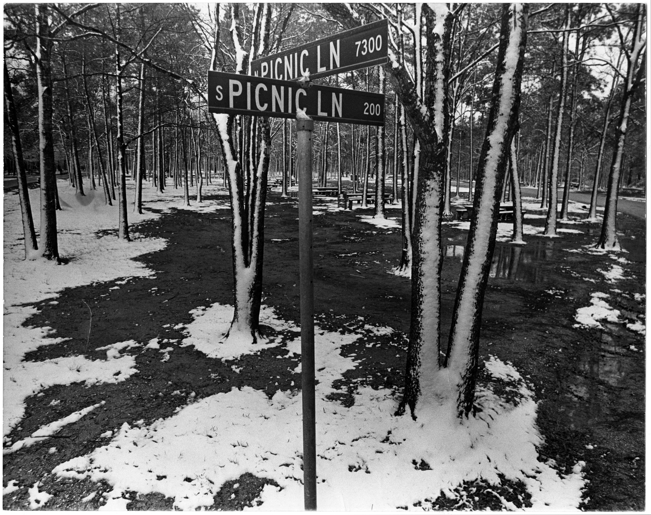
In a final note toward future work, it is not as though queer territories emerge through cruising in just any location where enough people gather. These seven narratives show that other factors matter, such as relatively immediate access to semi-private spaces like wooded areas in a park (Memorial Park), bathrooms in a shopping mall (The Galleria), or a nearby and affordable hotel (The Woodrow Hotel). That benefit of access to semi-private space also undergirds the complex and varied relationships cruising areas have with specifically commercial space, and with cruisers' socioeconomic status and access to capital more generally. As the downtown window-shopping scene of the 1930s demonstrates, those commercial spaces need not be specifically queer, but must at least enable moments for discrete (respectable) communication, perhaps at a post while combing one's hair. As historian John D'Emilio might put it, such urban commercial centers help create the "conditions of possibility" for individuals to organize their lives, even if only in the ephemeral practice of cruising, through their sexuality.82See John D'Emilio, "Capitalism and Gay Identity," in The Lesbian and Gay Studies Reader, eds. Henry Abelove, et al. (New York: Routledge, 1993): 467–476. Proximity to specifically queer-centered businesses also enabled many cruising areas, albeit in flexible ways. The policed street scene outside a new bar described by the 1963 writer to ONE is quite different from the scene R. L. Martinson complained of almost a decade later—"characters" circulating in commercial space "without merchandise"—but perhaps Martinson was looking for a different kind of goods. While both narrators remark on the increased pedestrian and street traffic, Story Book created a commercialized space for cruising (and its consummation) to occur out of direct public view at the same time as both police forces and local queer press sought to control public street cruising. Said differently, the "good" that Story Book commodified was the affordance of relative privacy. While one could pick up a trick while walking outside a bar and never directly pay for that privilege, Story Book extracts payment for access to fellow sex-seekers in a semi-public and therefore marginally safer place, perhaps even with better odds of finding an available or desirable partner. The cruising scene on the corner of Main and Bell as described in Ciao! offers a different arrangement still, where some but not all of the cruising is predicated on sexual partners exchanging money directly. Also profiting from that scene are the three businesses—a restaurant, a bar, and a hotel—though at least the restaurant operators were ambivalent enough about that source of income to change their hours of operation to avoid the roughest of the rough. As a final thought, these varied relations to commercial space and capital suggest that histories of cruising not only deepen our understanding of how queer territorialization comes to be through archipelagic processes, but they also offer fertile ground for exploring the liberating potentials and structuring limitations of sexuality under capitalism.
Acknowledgments
This essay was specifically inspired by Amy Stone's call to study the South.83Amy L. Stone, "The Geography of Research on LGBTQ Life: Why sociologists should study the South, rural queers, and ordinary cities," Sociology Compass 12, no. 11 (2018). https://doi.org/10.1111/soc4.12638. Also, while this essay concentrates on men's cruising in Houston, anyone might look for sex partners in public. As Samuel Delaney argues in Times Square Red, Times Square Blue, public spaces that encourage social mixing (sexually primed or not) across class and race lines yield a civic texture worth preserving. Yet in both popular and academic analyses of public sexual behavior, the practice of cruising remains predominantly linked to gay men.84For example, see William Leap, ed. Public Sex/Gay Space (New York: Columbia University Press, 1999). An analysis of queer urban space argued from cruising alone would reproduce that limiting linkage, and yield a proportionately myopic mapping. Also, an analysis of queer rural spaces would require a different set of analytics still, one more attuned to mapping social networks of queer rural denizens (see John Howard's work for example) than mapping brick and mortar locations.85See Gray, Mary L., Colin R. Johnson, and Brian J. Gilley, eds. Queering the Countryside: New frontiers in Rural Queer Studies (New York: NYU Press, 2016).
In a note of gratitude, more people than I can name here contributed in meaningful ways to this essay. I am thankful for my writing group; Melissa Bailar, Anne Chao, and Robert Werth saw this work in its very first stages. I am indebted to the Rice University Feminist Research Group and Christina Hanhardt for formative feedback on what turned out to be the bones of this essay. I am also grateful to JD Doyle, Martin Sunday, and the editors and anonymous peer reviewers of Southern Spaces for their insights and commentary. All errors and omissions remain my own responsibility.
Many thanks as well to Southern Spaces staff member Stephanie Bryan, who helped create the digital maps published here.
About the Author
Brian Riedel is the associate director of the Center for the Study of Women, Gender, and Sexuality at Rice University, where he received his Ph.D. in Anthropology. His work has been published in the Journal of Mediterranean Studies, PoLAR: Political and Legal Anthropology Review, Somatechnics, CITE: the Architecture and Design Review of Houston, and in the anthologies AIDS, Culture, and Gay Men (University of Florida Press, 2010) and Homophobias: Lust and Loathing Across Time and Space (Duke University Press, 2009).
]]>Introduction
. Courtesy of Wikimedia Commons. Image is in public domain.")
In August of 1920, Dr. Oscar Dowling, president of the Louisiana State Board of Health, alerted Governor John M. Parker about the increasing availability of a "powerful narcotic, causing exhilaration, intoxication, [and] delirious hallucinations." Dowling, later chairman of the American Medical Association's board of trustees, also wrote the US Public Health Service urging action to prohibit the spread of this drug throughout the country. Surgeon General Hugh S. Cummings replied to express his "complete agreement" with Dowling's concerns. Governor Parker, surprised to learn there was no federal law curbing the drug, wrote John F. Kremer, prohibition commissioner, and alleged, "two people were killed a few days ago by the smoking of this drug, which seems to make them go crazy wild."1David F. Musto, "The Marihuana Tax Act of 1937," Archives of General Psychiatry 26, no. 2 (February 1972): 102. For more on Dowling, see Richard J. Bonnie and Charles H. Whitebread, The Marijuana Conviction: A History of Marijuana Prohibition in the United States, Drug Policy Classic Reprint from the Lindesmith Center (New York: Lindesmith Center, 1999), 43–44. The drug was marijuana.2Though usually spelled "marijuana" today, "marihuana" was the most common spelling in the United States during the early twentieth century. Different spellings from that period also included: marajuana, mariguana, mariahuana, marahuana, marihuano, mariguana, in addition to other common names like "reefer" and "muggles." For consistency, I use "marijuana" throughout, unless directly quoting from sources with varied spellings.
Dowling and Parker's letters marked the early stages of the "marijuana menace"—a panic that coalesced around the alleged spread of marijuana use among criminals and school-age children in New Orleans between 1920 and 1930. In response, both the city and the state of Louisiana passed laws criminalizing the drug's use, sale, and possession. In the weeks that followed the passage of the city ordinance in 1923, police raided houses, restaurants, and soft drink stands to arrest suspected peddlers and users. Police and the press quickly dubbed users as "muggleheads," drawing on the street term for marijuana. A year later, following unanimous passage by the legislature, Governor Henry L. Fuqua signed a statewide law prohibiting marijuana. In the months and years that followed, civic groups and law enforcement officials in New Orleans launched more than one "muggles drive" and declared "war on dealers in marijuana."3For examples of these enforcement measures, see "Cops Make First Marihuana Raids," Times-Picayune (New Orleans), June 17, 1923; "Marijuana War Is Planned by Mrs. Gregson," Times-Picayune (New Orleans), November 30, 1924, sec. Three; "Ax Killer's Trial Set as 'Muggles' Drive Is Ordered," Times-Picayune (New Orleans), April 18, 1929; "Police Open New War on Dealers in Marihuana," Times-Picayune (New Orleans), October 26, 1930.
Previous studies of marijuana prohibition in the United States have given relatively little attention to city- and state-level events such as these, emphasizing instead developments that led to federal marijuana legislation in 1937.4For prominent examples, see Howard Becker, Outsiders: Studies in the Sociology of Deviance (New York: Free Press, 1963); Alfred Ray Lindesmith, The Addict and the Law (Bloomington: Indiana University Press, 1965); David Solomon, ed., The Marihuana Papers (Indianapolis: Bobbs-Merrill Co., 1966); Donald T. Dickson, "Bureaucracy and Morality: An Organizational Perspective on a Moral Crusade," Social Problems 16, no. 2 (Fall 1968): 143–56; Richard J. Bonnie and Charles H. Whitebread, "The Forbidden Fruit and the Tree of Knowledge: An Inquiry into the Legal History of American Marijuana Prohibition," Virginia Law Review 56, no. 6 (October, 1970): 971–1203; Michael Schaller, "The Federal Prohibition of Marihuana," Journal of Social History 4, no. 1 (October 1970): 61–74; Lester Grinspoon, Marihuana Reconsidered (Cambridge, MA: Harvard University Press, 1971); Musto, "The Marihuana Tax Act of 1937"; David F Musto, The American Disease: Origins of Narcotic Control (New Haven, CT: Yale University Press, 1973). The most influential and widely cited, Richard J. Bonnie and Charles H. Whitebread's The Marihuana Conviction (1974), acknowledges the importance of earlier state laws but offers a limited exploration of their origins or municipal counterparts.5Richard J. Bonnie and Charles H. Whitebread, The Marihuana Conviction: A History of Marihuana Prohibition in the United States (Charlottesville: University Press of Virginia, 1974). For instance, although Bonnie and Whitebread note New Orleans's influential role in fostering marijuana menace ideology, they provide only brief analysis on developments in the city and generally ignore passage of the city ordinance in 1923 and state law in 1924. Rather, they argue that until 1926, "very little . . . was done about the marihuana issue until the press seized upon it."6Bonnie and Whitebread, 44. Likewise, in assessing the city's marijuana users, Bonnie and Whitebread write that "use among black and lower-class white elements of New Orleans emerged along with the propensity toward use by youth."7Bonnie and Whitebread, 92. Moreover, younger users were "drawn from the same socioeconomic classes as the adult users."8Bonnie and Whitebread, 44. They offered little evidence for these claims, and believed New Orleans's officials responded to a general spike in crime during the 1920s by using marijuana as a "convenient scapegoat"—dismissing newspaper and law enforcement claims about the dangers of marijuana and its growing user population in the city as "propaganda."9Bonnie and Whitebread, 67, 71, 92. Bonnie and Whitebread's belief that the city's marijuana users came from fringe and minority groups served to bolster their broader argument that racism and xenophobia played a central role in driving marijuana prohibition nationwide. Despite its limited engagement with evidence drawn from the state and local level, this general interpretation has remained largely unchallenged.10For recent examples that draw heavily from Bonnie and Whitebread's interpretation, see Richard Davenport-Hines, The Pursuit of Oblivion: A Global History of Narcotics, 1st American ed. (New York: Norton, 2002); Martin Booth, Cannabis: A History, First U.S. Edition (New York: St. Martin's Press, 2004); Martin A. Lee, Smoke Signals: A Social History of Marijuana—Medical, Recreational and Scientific (New York: Simon and Schuster, 2013); Johann Hari, Chasing the Scream: The First and Last Days of the War on Drugs (New York: Bloomsbury Publishing USA, 2015). For three notable exceptions that have challenged aspects of Bonnie and Whitebread's conclusions and proved highly influential to my own research, see Jerome L. Himmelstein, The Strange Career of Marihuana: Politics and Ideology of Drug Control in America (Westport, CT.: Greenwood Press, 1983); Dale H. Gieringer, "The Forgotten Origins of Cannabis Prohibition in California," Contemporary Drug Problems 26, no. 2 (Summer 1999): 237–88; Isaac Campos, Home Grown: Marijuana and the Origins of Mexico's War on Drugs (Chapel Hill: University of North Carolina Press, 2012).
In contrast, this essay utilizes contemporary coverage from the Times-Picayune newspaper to analyze the impetus for marijuana prohibition and enforcement in New Orleans as well as the spatial and demographic characteristics of the marijuana users arrested. As one of the earliest urban markets for illicit marijuana use, New Orleans offers an excellent case study for testing prominent aspects of the existing historiography. Given what we now know about marijuana's effects, there is certainly much to critique about the often-hyperbolic commentary on its dangers during the 1920s. Nevertheless, contemporary newspaper coverage sheds light on the origins of those claims as well as the hundreds of marijuana arrests that took place in the city. Many of these reports provided information about the suspects, including their names and arrest locations, the quantity of marijuana seized, home addresses, race, and age. What follows is an examination of the sharp rise in commentary on the dangers of marijuana use alongside an analysis of 225 documented arrests during the first seven years of citywide prohibition. These arrests represent only incidents covered in some detail by the Times-Picayune and provide a valuable database for suggesting patterns and trends among the city's users.11Between May 1923 and December 1929, the Times-Picayune published at least three hundred stories with references to marijuana, roughly one per week. The number of articles mentioning marijuana more than doubled during the subsequent seven-year period. From 1930 through federal marijuana prohibition in 1937, the newspaper published more than six hundred and fifty pieces referencing marijuana, demonstrating the continued growth of public concern with the drug. When combined with an analysis of the simultaneous rise in commentary on marijuana's dangers, this essay and accompanying interactive digital map challenge previous interpretations, revealing both a rapid association between marijuana and crime as well as evidence for a predominately young, white user population that helped drive local concern and provided the impetus for legal prohibitions in New Orleans and beyond.
Youth, Crime, and "Marijuana War"
On February 18, 1922, the New Orleans Times-Picayune announced that a new drug habit was growing rapidly in the city. Citing Dr. Oscar Dowling, who first raised the alarm on marijuana some two years earlier, the newspaper reported the "passage of a drastic law to curb the constantly growing practice of selling and smoking marijuana, also known as muggles, will be sought at the next session of the Legislature." Federal assistance also appeared to be on the way. G. W. Cunningham, chief federal narcotic officer for Louisiana, asserted that, "a measure is to be introduced into Congress which would put marijuana in the same class with morphine, cocaine and opium." Cunningham also "rapped the popular impression that marijuana is not harmful"—suggesting its use may have already reached a critical mass in New Orleans. He believed marijuana "was as habit forming as morphine or cocaine" and that "constant smoking will ruin the health."12"New Drug Habit Rapidly Growing, Health Heads Say," Times-Picayune (New Orleans), February 18, 1922. Though a federal law targeting marijuana use would not pass for another fifteen years, the House Judiciary Committee held hearings on the "Prohibition of Peyote and Marijuana in Interstate Commerce" in 1922.
How much the public knew about marijuana is difficult to assess. In October 1921, a Times-Picayune reader wrote about the paper's recent "allusion to the narcotic preparation of a plant called 'marijuana.'" The reader hoped to learn "where it is grown; its effect on the human system and if it is injurious or otherwise." Such questions suggest a general lack of awareness surrounding marijuana in the early 1920s, but that appeared to be rapidly changing. The newspaper's editorial reply included a range of speculation and confusion alongside information on the effects of cannabis drawn from medical journals. It noted correctly that marijuana "consists chiefly of the flowering tops and tender leaves and stalks of the Indian hemp (Cannabis indica)." Yet, it speculated, "the name 'marijuana' is probably a corruption of the 'majoon' of Calcutta, the name given to the hashish made in that city."13"Questions and Answers," Times-Picayune (New Orleans), October 23, 1921, sec. Two. Furthermore, the editorial connected the word hashish with the etymology of the term "assassin"—an oft-cited legend stretching back to Marco Polo and the Crusades.14For extensive analysis of the link between hashish and Islamic assassins, see Jerry Mandel, "Hashish, Assassins, and the Love of God," Issues in Criminology 2, no. 2 (1966): 149–56; Farhad Daftary, The Assassin Legends: Myths of the Ismaʻilis (London: Tauris, 1994); Campos, "Cannabis and the Psychoactive Riddle," in Home Grown: Marijuana and the Origins of Mexico's War on Drugs, 7–38. Just prior to the passage of the federal Marihuana Tax Act, Harry J. Anslinger, first and long-time commissioner of the Federal Bureau of Narcotics, subsequently made this link famous in "Marijuana: Assassin of Youth," The American Magazine 124, no. 1 (July 1937). The Times-Picayune also included an assessment of the drug summarized from existing medical literature:
The effects differ according to the dose and the idiosyncrasy of the individual. One of the first appreciable effects of the drug is the gradual weakening of the powers of controlling and directing the thoughts. This is followed by dreams accompanied by errors of sense, false convertions [sic], and the predominance of one or more extravagant ideas. A minute may seem a year and an hour only an instant; sounds may be exaggerated, and the sense of duration of time and extent of space and the appreciation of personality are lost. Some individuals become pugnacious, while others fall into a state of reverie. After small doses there is a great tendency to causeless merriment. Although less certain in its action than opium, it is said to possess certain advantages over that drug—that it does not induce torpidity of the liver, create nausea or check the secretions, and it is less likely to occasion headache.15"Questions and Answers."
In short, the Times-Picayune editorial tied marijuana to more familiar forms of cannabis, namely eastern hashish, while ably summarizing some of the existing medical information of the drug.16On the heels of pioneering experiments with cannabis conducted in India by Dr. William Brooke O'Shaughnessy, American physicians began debating the potential merits and dangers of cannabis in the 1840s and regularly published their assessments in prominent medical journals. By the late nineteenth century, most agreed that cannabis could be both helpful and harmful and was therefore in need of legal regulation and medical oversight. Nonetheless, after the turn of the century, ongoing difficulty in standardizing medicinal preparations and occasionally frightening side effects in patients led to steady declines in medicinal cannabis use. For an example promptly assessing O'Shaughnessy's work with cannabis, see W.B. O'Shaughnessy, "New Remedy for Tetanus and Other Convulsive Disorders," The Boston Medical and Surgical Journal XXIII, no. 10 (October 1840): 153–55. On the evolution of American physicians' assessment of cannabis medicines, see Adam Rathge, "Cannabis Cures: American Medicine, Mexican Marijuana, and the Origins of the War on Weed, 1840–1937," (PhD diss., Boston College, 2017), http://hdl.handle.net/2345/bc-ir:107531. It was not a difficult leap to more frightful effects characterized by exhilaration, intoxication, and aggressiveness.
As marijuana moved into the public consciousness of New Orleans in the early 1920s, characterizations of its potentially dangerous effects took hold.17For examples, including comparisons between marijuana addiction and stamp collecting as well as a casual mention of marijuana smoking, see "Just What Is Dishonesty," Times-Picayune (New Orleans), July 1, 1923, sec. One-B; "Literature—and Less—Comments on the Books of the Day," Times-Picayune (New Orleans), July 15, 1923. In May 1922, the Times-Picayune proclaimed "'Muggles' Incites Orleans Youths to Crime" and cited Police Detective Paul R. Maureau who blamed the "Mexican drug" for rash of "outbreaks by boy addicts." Maureau claimed one fourteen-year-old automobile thief was a "member of a gang that was accustomed to smoke 'mirauana' or 'muggles' cigarettes, which are supposed to produce recklessness unrivaled by other 'dope.'" Likewise, a juvenile court judge declared that "several boys have admitted using 'mirauana' to 'get up their nerve' for theft and other offenses." One of the boys testified the drug was available as dried leaves or ready-made cigarettes, purchased for twenty-five cents each. Just one cigarette, claimed Detective Maureau, could "contain criminal inspiration for four or five youths." To solidify the link between marijuana use and crime, Maureau affirmed that a man "arrested recently for the murder of a woman was found to be under the influence of 'mirauana.'"18"Says 'Muggles' Incites Orleans Youths to Crime," Times-Picayune (New Orleans), May 29, 1922.

Stories of marijuana use bolstered fear of its spread, prompting a swift response by the city's commission council. On May 18, 1923, the Times-Picayune highlighted the hospitalization of Randall Sharp—"another victim of the Mexican dope, 'Marijuana.'" Physicians at Charity Hospital "declared there is an epidemic of smoking the contraband in New Orleans and that scarcely a day passes without two or three persons being sent there for treatment." The news story further noted an increase of marijuana "in the city within the last few months."19"Mary Warner Epidemic," Times-Picayune (New Orleans), May 8, 1923. Two days later, at the request of District Attorney Marr and a number of medical professionals, City Commissioner Maloney introduced an ordinance "to make illegal the sale of 'cannabis indica,' better known as 'Mari Juana' or the 'Mexican happy smoke.'"20"Council to Act on Sale in City of Mary Warner," Times-Picayune (New Orleans), May 20, 1923; "Use of Mexican Dope Forbidden by City Council," Times-Picayune (New Orleans), May 30, 1923. On May 29, the council officially prohibited possession and sale of marijuana in New Orleans, with violations punishable by a fine of up to $25 and thirty days of imprisonment.21"Use of Mexican Dope Forbidden by City Council"; "A Yarn of Many Threads," Times-Picayune (New Orleans), July 1, 1923, sec. One-B.
A number of factors contributed to the city's efforts to curb marijuana. The drug was frequently among those sold by street peddlers. Its presence alongside other drugs and alcohol seized during police raids bolstered its prominence.22For two examples, see "Police Capture Weed, Wine and Owners in Raid," Times-Picayune (New Orleans), August 26, 1922; "Drug Ring Hunt Seems to Score," Times-Picayune (New Orleans), December 24, 1922. Early reports on marijuana occasionally noted that it arrived in New Orleans via the city's many shipping docks, often tying the drug to Mexican seamen and foreign vessels.23For example, see "Narcotic Leaves Seized on Vessel," Times-Picayune (New Orleans), September 21, 1922. There was also a quick and clear characterization of marijuana's apparent dangers together with dire warnings about its growing use. Prominent physicians and government officials fostered and reinforced these characterizations, and the purported connections between marijuana use and criminal activity.
Nevertheless, the alleged use of marijuana by schoolchildren appears to have been the primary factor in driving city's prohibitory action. A Times-Picayune exposé entitled "The Victim" chronicled what many believed was happening to an alarming number of youthful users. In the parlor of a former mansion turned tenement, reporter Lyle Saxon sat with the mother of a young boy who wept as she said, "To think that this has happened to my little boy, only twelve years old, and a victim of drugs." Her son Seth and his fourteen-year-old brother had sold newspapers after school. All was well until she "began to notice that something was wrong" with Seth: he "would come home with his eyes wide open, staring, but he seemed half asleep. He would say strange things."24Lyle Saxon, "The Victim," Times-Picayune (New Orleans), June 3, 1923, 20. It is worth noting that while marijuana's effects are often widely varied, its use may have the exact opposite effect on a user's eyes—constricting rather than widening. Known as photophobia, this squint is now a common trope in pop culture references to marijuana use. Many of the tropes in this story appear drawn from the temperance movement. For an exploration of how "eyes wide open" was often used as a symbol of madness linked with marijuana use, see Campos, Home Grown, 155–80. Seth would "sleep like a log" and in the morning, his mother would be unable to wake him up for school. He began missing school entirely and bringing home less and less money from the newspaper sales that helped support the family. When asked, "he couldn't account for where it had gone."25Saxon, "The Victim," 20. Seth also began to "stay out all night," until one day he simply did not come home. Missing for three days, his father went in search of him, eventually "coming home with the boy in his arms, his little head hanging down like he was dead." When Seth's parents called the police, they said he "had been smoking marihuana," or "Muggles."26Saxon, 27.

Social workers, physicians, and local police often confirmed the spread of marijuana smoking among school-age children. The findings of Mrs. Emma B. Stanton, who conducted "an investigation among the small boys and youths of the city," escalated the belief that marijuana was widely available. Stanton claimed that she provided a seven-year-old boy with some money and sent him into a saloon. The boy emerged "a few moments later with a little packet of marihuana, rolled in a bit of newspaper—and with the information that a man inside had offered to roll the cigarettes for him because he was too little to roll them himself."27Saxon, 27. An investigation by Lazu Block, chief attendance officer of parish schools, also found evidence of marijuana use among school-age children. At this news, a collective of more than sixty-three affiliated parent-led education clubs (the President's Cooperative Club) met with the district superintendent and adopted "resolutions approving the efforts of the commission council and the chief of police to stop the sale of marihuana or 'muggles' cigarettes."28"Children Using 'Mary Warner,' Officials Fear," Times-Picayune (New Orleans), June 16, 1923.
In July 1923, the Times-Picayune described "Muggles" as the "boon of newsboys and school children who haven't the means to purchase a more expensive drug."29"A Yarn of Many Threads," Times-Picayune (New Orleans). Reporter Lyle Saxon characterized the situation as especially dire: "to curb the smoking of marihuana is an arduous task—as so many boys and men have acquired the habit, and they will brave almost anything in order to get their daily 'shot.'" Saxon believed "the tragedy of the situation is that this drug is striking at the very roots of society in attacking the children." Marijuana use was quickly "making them slaves, not only to the drug, but to those unscrupulous boys and men who find it to their advantages to 'dope' the children, taking from them their hard-earned pennies, gained by selling papers, shining shoes and so on, leaving the children sleeping in alleys, in gutters and in the streets."30Saxon, "The Victim," 27.
Professional medical opinions urged immediate social intervention and police enforcement, stressing the potential dangers of marijuana. "There is little difference in the effects of marihuana and hashish," said Dr. E. J. DeBergue, assistant city coroner. "When first used it produces a form of mild exhilaration. With constant use this exhilaration passes and one uses the drug simply to feel normal." When compared to "more powerful drugs," DeBergue added, "marihuana gives its addicts an appearance of listlessness, numbness, and a general lack of energy. . . . It produces protracted insomnia and may lead to temporary insanity." In short, marijuana was "intensely harmful."31"A Yarn of Many Threads." Dr. John M. Fletcher, professor of psychology at Tulane University, president of the Southern Society for Philosophy and Psychology, and later chairman of the Louisiana Educational Survey Commission, painted a similar picture of marijuana's dangers. Though not a medical doctor, Fletcher analyzed samples of the drug seized during police raids and summarized the existing, if conflicting, characterizations surrounding it. "In use for centuries as a narcotic stimulant," Fletcher noted the effects were "both mental and physical." Users showed "a gradual weakening of the thought processes, together with extreme errors of sense of time and space." Long-term use led to "indigestion, wasting of the body, cough, melancholy, impotence and dropsy." Eventually, Fletcher claimed, "its votary becomes an outcast from society, and his career terminates in crime, insanity and idiocy."32Saxon, "The Victim," 27.

These grave assessments and the growing fear of marijuana's spread among children fueled calls for additional legislative action. In May 1924, newly elected representative Fred W. Oser, a former police reporter for the Times-Picayune and secretary to the commissioner of public safety in New Orleans, brought the city's desire for marijuana enforcement to the state legislature in Baton Rouge. Oser said he often "observed the evils of marijuana," and one of his first actions was to introduce statewide anti-marijuana legislation.33For Oser's quotes see "Red Sticks—Against Marijuana," Times-Picayune (New Orleans), May 14, 1925, 3; "Bills Introduced," Times-Picayune (New Orleans), May 15, 1924, 2. His proposal, which sought to forbid the sale and transportation of marijuana, carried mandatory provisions for a fine and imprisonment and prohibited the trial judge from suspending the sentence. In early June, the judiciary committee of the House favorably reported on the bill.34"Bill Outlaws Marijuana," Times-Picayune (New Orleans), June 4, 1924, 2. Little more than a week later, Oser presented the bill for a vote and insisted there should be no objection from his colleagues. His fellow representatives declared the bill was "splendid and badly needed," insisting, "such a law is absolutely necessary." Oser's bill swept through the chamber, "84 yeas to no nays."35"House Warms Up to Legislative Work," Times-Picayune (New Orleans), June 13, 1924, 4. On July 1, 1924, Governor Henry L. Fuqua signed the legislation into law. The measure allowed for limited sale of specific medically prescribed cannabis preparations, but otherwise prohibited possession, sale, and transportation.36The law restricted prescriptions to medicinal preparations containing a limited percentage of cannabis extract. "Marajuana Outlawed," Times-Picayune (New Orleans), July 2, 1924, 15; "Bills Signed by Governor Fuqua," Times-Picayune (New Orleans), July 13, 1924, sec. One-B, 5; "Orleans Parish Lawmakers to Tell About It at Dinner," Times-Picayune (New Orleans), July 28, 1924, 3.
Backed by the city ordinance and state law, New Orleans law enforcement agents and civic clubs continued their efforts to curb marijuana use, especially among youth. In May 1925, New Orleans coroner, George F. Roeling urged "police cooperation with his department in endeavoring to trace the source from which persons under his care for observation obtain alcohol, habit-forming drugs and 'muggles.'"37"Mentality Tests for Speeders Urged by Coroner Roeling," Times-Picayune (New Orleans), May 31, 1925, 1. A meeting of the New Orleans Federation of Clubs in November included continued allegations of marijuana use by young children. "Marijuana is being sold in drug stores and candy stores throughout the city," declared Mrs. Emma Bell Stanton. "School boys are smoking this pernicious drug in cigarettes, and school girls, automobile riding at night, are becoming intoxicated by it."38"Women to Fight Marijuana Sale," Times-Picayune (New Orleans), November 25, 1924, sec. Part Two, 17. Mrs. Charles Gregson, chair of the Federation of Clubs committee on anti-narcotics, declared "Marijuana War." The first battle aimed to stop use of the marijuana cigarette—what Gregson called "a stepping stone" toward the "use of even more vicious and degrading narcotics."39"Marijuana War Is Planned by Mrs. Gregson." Gregson's use of the term "stepping stone" here may signal the origins of the "gateway drug" theory that ultimately proved highly influential in bolstering a prohibitory stance on marijuana throughout the second half of the twentieth century. Police Detective Henry Asset stressed that the effects of marijuana were "not so deadly in themselves, but in many instances they lead to the use of more powerful drugs."40"A Yarn of Many Threads," Times-Picayune (New Orleans). Mrs. Gregson planned to host a series of lectures for civic clubs and older children on the evils of the drug traffic, and called upon concerned citizens to notify her of places where marijuana cigarettes were sold.41For coverage of Gregson's announcement, see "Marijuana War Is Planned by Mrs. Gregson," 9; "No Man's Land," Times-Picayune (New Orleans), December 14, 1924, sec. Three, 15.
The Louisiana Board of Health called upon Dr. Carleton Simon, a narcotic expert, deputy police commissioner, and lecturer on criminology in New York, to conduct a survey of drug use in the state. Simon's investigation concluded that, "thousands of young men and women in Louisiana are addicted to the use of marijuana, known in underworld haunts as 'muggles' and 'moota.'"42"Thousands of State's Youth Marijuana Addicts, Survey by Criminologist Show," Times-Picayune (New Orleans), August 12, 1926, 6. School officials and parent groups reaffirmed Simon's assessment.43For examples, see "Women to Probe Drivers' License Issuance System," Times-Picayune (New Orleans), October 26, 1926, 3; "National Officer of School Clubs Will Visit," Times-Picayune (New Orleans), October 28, 1926, 5; "Public School Vice Quiz Opens Feb. 23," Times-Picayune (New Orleans), February 20, 1927; "School Alliance Holds Meeting—Stricter Legislation Towards Marijuana Sellers Is Urged," Times-Picayune (New Orleans), May 10, 1927; "School Children Smoke Muggles, Alliance Is Told—Startling Reports Made at Meeting by Mrs. J.G. Skinner," Times-Picayune (New Orleans), May 13, 1928. In January 1927, A. H. Seward, president of the Public School Alliance (PSA), charged that marijuana was "being sold to children in the grammar and high schools."44"Gambling in City Leaves Its Mark on School Boys," Times-Picayune (New Orleans), January 11, 1927, 2. By November, the PSA reported, "a slight increase in the number of marijuana, or 'muggles,' cigarettes sold to and smoked by grammar school children." Some of those children were "as young as those of the fourth and fifth grades" with "traces of this habit . . . seen as early as the third grade."45"More Children Smoke Muggles Alliance Hears," Times-Picayune (New Orleans), November 15, 1927, 2.
![Black newspaper-style text on a white background that reads, "(Sample--Warning card to be placed in R. R. Trains, Buses, Street Cars, etc.) Beware! Young and Old — People in All Walks of Life! This [image of marijuana joint] may be handed to you [image of smiling man and woman] by the friendly stranger. It contains the Killer Drug 'Marihuana' — a powerful narcotic in which lurks Murder! Insanity! Death! [Image of marijuana plant] WARNING! Dope peddlers are shrewd! They may put some of this drug in the [image of teapot] or in the cocktail or in the tobacco cigarette. Write for detailed information, enclosing 12 cents in postage—mailing cost. Address: The Inter-State Narcotic Association (incorporated not for profit) 53 W. Jackson Blvd. Chicago, Illinois, U. S. A."](https://southernspaces.ecdsdev.org/wp-content/uploads/2019/07/rathge_005_psa.jpg "Marijuana Warning Poster, ca. 1971. Poster by Inter-State Narcotics Association. Courtesy of the Wisconsin Historical Society.")
The PSA findings resulted in renewed calls for federal intervention.46Their efforts mirrored earlier attempts out of New Orleans urging federal action on marijuana, dating to Dr. Dowling's letters in 1920. For additional examples, see "We Want Walmsley for Congress," Times-Picayune (New Orleans), March 23, 1924, sec. One-B; "Women Endorse City Bond Issue—Federation of Clubs Will Ask Us Action Against Marijuana," Times-Picayune (New Orleans), November 23, 1926, 19. On the Public School Alliance, see "Alliance Seeks Government Ban on Marihuana," Times-Picayune (New Orleans), December 12, 1928, 37. In December 1928, W.O. Hart, PSA legislative committee chairman, began working with Louisiana Representatives James Z. Spearing and James O'Connor to amend the existing federal Harrison Narcotic Act to include marijuana.47The Harrison Narcotics Act of 1914 regulated and taxed the production, importation, and distribution of opiates and coca products as well as closely monitored the proscribing habits of registered physicians. Congressman Spearing was a longtime member, and two-time president, of the Orleans Parish School Board as well as a member of the Louisiana State Board of Education. "Despite the efforts of the alliance and of its private investigators," declared PSA president A. H. Seward, the traffic in this social leprosy still goes on" and would until Congress passed "suitable legislation, laws with teeth in them."48"Children Smoke Marihuana, Says Head of Alliance—Fight for More Severe Legislation to Be Carried On," Times-Picayune (New Orleans), January 15, 1929, 12; "Alliance Seeks Government Ban on Marihuana," 37. That New Orleans played a central role in raising the issue made news as far away as New York—where headlines seized on the city's "fight to save school children."49"War on Hashish Smoking Is Carried to Congress in Effort to Save School Children," The Brooklyn Eagle, December 20, 1928, 3; "Federal Agents Powerless to End Hashish Traffic," The Brooklyn Eagle, December 21, 1928.
The existence of Mrs. Gregson's "marijuana war," the efforts of civic clubs and the PSA, as well as consistent police enforcement demonstrate that prohibitory marijuana laws in New Orleans remained anything but "dormant."50See Bonnie and Whitebread, The Marijuana Conviction, 44. According to Bonnie and Whitebread, in the fall of 1926, New Orleans police suddenly "arrested more than 150 persons for violation of a law which had lain dormant for two years." It is unclear if they mean the city ordinance or the state law. Nevertheless, given the evidence shown here, there was obviously significant attention focused on marijuana for at least four to six years prior to that particular enforcement sweep in 1926. Contemporary reports clearly show continued enforcement and arrests for marijuana under both the city ordinance and state law throughout this period. There was significant and consistent activity aimed at curbing marijuana use in the city beginning in the early 1920s. For the period between June 1923 and December 1929—roughly the first seven years of enforcement for the city's ordinance—reporting from the Times-Picayune highlighted 225 documented marijuana arrests. The paper's reports shed light on the activities of law enforcement as well as the spatial and demographic characteristics of those arrested. Measuring the prevalence of marijuana use in New Orleans during this period remains difficult given the many source biases and limitations surrounding illicit substances. Examining these reports, however, reveals a user population with characteristics different from those often described by contemporary commentary and subsequent historical studies.
Marijuana Users in Time and Place
One of the most striking differences between the newspaper evidence and the existing historiography on marijuana prohibition is the size of the marijuana market. Most historical studies have suggested marijuana use in the 1920s was a highly regionalized, marginal practice confined to Mexican immigrants and fringe groups and likely exaggerated by contemporary sources.51For examples, see Musto, The American Disease; Bonnie and Whitebread, The Marihuana Conviction; John Helmer and Thomas Vietorisz, Drug Use, the Labor Market and Class Conflict (Washington: Drug Abuse Council, 1974); John F. Galliher and Allynn Walker, "The Puzzle of the Social Origins of the Marihuana Tax Act of 1937," Social Problems 24, no. 3 (1977): 367–76; Himmelstein, The Strange Career of Marihuana. The available evidence from New Orleans suggests otherwise.52The widespread digitization of newspapers and related online databases has undoubtedly made this evidence more accessible to researchers and reinforces the need to reevaluate earlier interpretations. Police activity in the city yielded arrests for possession of a single marijuana cigarette to seizures as large as forty pounds. In 1922, the Times-Picayune recorded three raids netting large quantities. In August, police raided the apartment of Genara Prugillo and Lorenzo Espinoza capturing twenty-one gallons of wine and one hundred and ninety packets of marijuana.53"Police Capture Weed, Wine and Owners in Raid," Times-Picayune (New Orleans). A month later customs officials searched a Mexican steamship moored in New Orleans and seized "two large packages of Mexican Marijuana leaves" valued at New Orleans retail prices exceeding $800.54"Narcotic Leaves Seized on Vessel," Times-Picayune (New Orleans). In December, New Orleans police and federal agents completed an undercover investigation they believed would "smash" a local "narcotic ring." The alleged ringleader was captured with "more than $9,000 of cocaine, morphine and mariahuana."55"Drug Ring Hunt Seems to Score," Times-Picayune (New Orleans). Little more than a year later, New Orleans police made a series of arrests that netted similarly large amounts of marijuana, including seizures of fifteen pounds, five pounds, forty pounds, and ten pounds.56"Marihuana Haul Made By Police," Times-Picayune (New Orleans), January 17, 1924; "American Craze for Marihuana Builds Industry," Times-Picayune (New Orleans), March 10, 1924; "Arrest Marihuana Seller," Times-Picayune (New Orleans), March 10, 1924, 14; "Marijuana Seized Valued at $3,000," Times-Picayune (New Orleans), April 20, 1924, sec. Five, 8; "Decision Upholds Recorder's Stand," Times-Picayune (New Orleans), May 1, 1924; "Alleged Ex-Convict Held, Drug Seized," Times-Picayune (New Orleans), May 31, 1924, 3.
Given such volume, it is hard to dismiss the situation in New Orleans as journalistic sensationalism or law enforcement propaganda although it is easy to criticize the contemporary assessment of the dangers posed by marijuana use given our present understanding. The size and frequency of seizures in New Orleans during the early 1920s attest to the scope of the city's marijuana market. Arrests for simple possession as well as large quantities occurred regularly. Street-level arrests and sting operations often yielded only a few marijuana cigarettes, while quantities seized at larger busts ranged from hundreds of pre-rolled cigarettes to many pounds of bulk marijuana.57For examples of large marijuana seizures, see "Woman Charged Under Drug Act," Times-Picayune (New Orleans), September 27, 1924, 2; "Marijuana Seized," Times-Picayune (New Orleans), July 17, 1925, 23; "Liquors and Drugs Seized by Agents," Times-Picayune (New Orleans), March 23, 1926; "Healy Launches Attack on Vice and Marihuana," Times-Picayune (New Orleans), October 17, 1926; "Marijuana Leads to Arrest of Four," Times-Picayune (New Orleans), January 16, 1927; "Marijuana Drugs Are Seized on Ship," Times-Picayune (New Orleans), February 10, 1927, sec. Part Two; "Woman Is Accused of Marijuana Sale," Times-Picayune (New Orleans), June 28, 1927, sec. Part Two; "Two Marijuana Loads Confiscated," Times-Picayune (New Orleans), October 8, 1927; "Agents on Trail of Large Liquor Smuggling Ring," Times-Picayune (New Orleans), November 11, 1927; "Marihuana, Rum Seized by Federal Officers on Ships," Times-Picayune (New Orleans), February 10, 1928; "$5000 in Marihuana Taken from Ship," Times-Picayune (New Orleans), February 29, 1928; "Marihuana Seized by Captain at Sea," Times-Picayune (New Orleans), March 22, 1929; "Customs Agents Seize Marihuana Valued at $7500," Times-Picayune (New Orleans), October 4, 1929, sec. Part Two. These stories signal a market environment with both large-scale peddlers and small quantity buyers.
The evidence also hints at the existence of a subset of repeat offenders. During the city's "first marihuana raids," for example, police arrested Antonio Bernade and his wife—owners of the Black Cat Restaurant—with "twelve packs of the weed."58"Cops Make First Marihuana Raids," Times-Picayune (New Orleans). Just a week later in a second restaurant raid, police arrested Bernade again, finding marijuana "concealed in a false window."59"Alleged Marihuana Seized," Times-Picayune (New Orleans), June 24, 1923. Less than a month later, police alleged that Mrs. Bernade absconded with the marijuana as officers arrived. Mr. Bernade was arrested a third time on charges of selling marijuana cigarettes to Dominick Potania—"a member of one of New Orleans' best families"—as Potania was leaving the restaurant, giving them reason enough to enter.60"Restaurant Man Sold Marihuana, Police Charge," Times-Picayune (New Orleans), July 8, 1923, 9. A report for this arrest gave a different restaurant address and a slightly differently spelling of his name—Antonio Bernabe. Potania seems to have continued his involvement in the illicit drug market. Six years later, a newspaper report chronicled his arrest alongside Carlo Giacona. According to police, Potania "attempted to conceal a packet of cocaine" while Giacona was "alleged to have had a marihuana cigarette."61"Cocaine, Marihuana Found, Two Jailed," Times-Picayune (New Orleans), May 24, 1929. Giacona was ultimately not tried for this offense, see "Records of the Day—Criminal Court," Times-Picayune (New Orleans), June 15, 1929. Two months later police arrested Giacona again following a raid on his boarding room, where detectives reportedly found "a pound of marihuana seeds."62"Police Nab Youth, Seize Marihuana," Times-Picayune (New Orleans), August 1, 1929. Another repeat offender, Sam Farace, faced criminal charges following his arrest with "a pillow slip containing ten pounds of raw marihuana weed." Just out of state prison, Farace was the proprietor of a "soft drink establishment" that city officials alleged was "a rendezvous for thieves and police characters."63"Alleged Ex-Convict Held, Drug Seized," Times-Picayune (New Orleans), 3. Three years later, during a raid on his family's restaurant, police arrested Farace's younger brother Joseph with two dozen marijuana cigarettes. During that incident, Sam Farace reportedly interfered with the police operation and was "arrested, and charged with disturbing the peace."64"Youth Is Taken in Marijuana Raid," Times-Picayune (New Orleans), April 3, 1927, 15.
The presence of repeat offenders suggests a substantial market for the drug with significant financial incentives. Both offenders and those pushing for stiffer penalties raised the idea that penalties for violation of the city's marijuana ordinance were too weak.65For examples, see "A Yarn of Many Threads," Times-Picayune (New Orleans); "Marihuana Peddler Fined," Times-Picayune (New Orleans), July 3, 1923; "American Craze for Marihuana Builds Industry," Times-Picayune (New Orleans); "Arrest Marihuana Seller," Times-Picayune (New Orleans), 14. Valdo Santos spoke with Times-Picayune reporters following his first arrest on marijuana charges and claimed, "It's not hard to get through. Most of it comes overland, through Texas. We pack it in a suitcase and when we sell out we go back for more. It's easy and a good business. Beats bootlegging and the fines are smaller."66"American Craze for Marihuana Builds Industry." For Santos, this apparently meant big rewards and small consequences. He was arrested again a year later with five pounds of marijuana and forty-eight pre-rolled cigarettes.67"Arrest Marihuana Seller," 14. Police Detective Henry Asset agreed that the punishments for marijuana were not a major deterrent and believed violators easily managed to pay the $25 fine. "Any good peddler," he argued, "can raise that amount."68"A Yarn of Many Threads."


Evidence from the Times-Picayune offers some sense of the diversity of people, places, and situations involved in marijuana arrests. Police regularly targeted soft drink stands, groceries, and restaurants and often implicated them as sites of illicit activity, including the smoking and selling of marijuana.69"Liquor and Mary Warner Seized," Times-Picayune (New Orleans), June 5, 1924, 26. In April 1924, for instance, following an undercover purchase at the restaurant of Manuel Arredondo, New Orleans police confiscated some forty pounds of marijuana. Valued at nearly $3,000, the stash was "concealed in the rear of the place under a trapdoor."70"Marijuana Seized Valued at $3,000," Times-Picayune (New Orleans), 8. Police frequently made marijuana arrests on the streets and sidewalks, including eight young men found smoking in Coliseum Square.71For this instance and others, see "Alleged 'Muggles' Habitues Are Fined," Times-Picayune (New Orleans), July 29, 1923, 3; "More Patrolmen Are Transferred," Times-Picayune (New Orleans), September 10, 1923, 13; "Finds Marihuana in Martina's Store," Times-Picayune (New Orleans), October 17, 1923, 7. Though reports suggest police arrested men far more often, there were also female marijuana peddlers arrested.72The roles women have played in the business of drug trafficking is highly understudied. See Elaine Carey, Women Drug Traffickers: Mules, Bosses, and Organized Crime (Albuquerque: University of New Mexico Press, 2014). Mrs. Carrie O'Donnell was in her grocery store and place of residence when police "found thirty-seven marijuana cigarettes, which complainants said she kept for sale."73"Unable to Find Verboten Law," Times-Picayune (New Orleans), October 2, 1924, 7. Police arrested Mrs. Sadie Garden at home where detectives seized "several thousand marijuana cigarettes, bulk marijuana, a box of morphine and a quantity of grain alcohol."74"Woman Charged Under Drug Act," Times-Picayune (New Orleans), 2. In an era of alcohol prohibition, police frequently seized marijuana alongside liquor.75For just one example, see "Possession Is Charged," Times-Picayune (New Orleans), July 30, 1925, 16.
Reporting also linked marijuana seizures to the city's many ships and sailors. Often, federal customs agents were involved in these incidents. Though the Harrison Narcotic Act did not cover marijuana, a 1915 Treasury Decision banned the importation of cannabis if intended for other than medical purposes.76W. G. McAdoo, Treasury Decisions Under Customs and Other Laws, vol. 29 (Washington, D.C.: U.S. Government Printing Office, 1916), 257. In early 1925, two Mexican seamen faced marijuana charges. Police arrested Antonio Corres on the city docks with "a bag containing marijuana."77"Smuggler Sentenced," Times-Picayune (New Orleans), March 5, 1925, 12. In a separate incident, a customs official trailed Manual Gonzalez as he left the steamship Yuma, leading to his arrest for "possessing six pounds of marijuana."78"Marijuana Seized," Times-Picayune (New Orleans), 23. In a third incident, Juan Horgoros, a "Spanish Seaman," faced marijuana possession charges following his arrest by a customs official.79"Spanish Seaman Held," Times-Picayune (New Orleans), October 21, 1925, sec. Part Two, 17. Four years later, customs agents apprehended William Shanakan and Edward Busamente near the Desire street docks as "the pair attempted to land a small skiff underneath the wharf apron and smuggle ashore seven bags of marihuana." The two men obtained the drug from "unnamed members of the crew of the Honduran steamship Baja California." Shanakan and Busamente floated "with the current alongside the ship on the river side and the bags of the hasheesh weed had been let down from a port-hole to the skiff." Since customs agents could not implicate individual crewmembers, they levied a fine on the entire steamship for "unmanifested contraband."80"Pair Arrested Trying to Land with Marihuana," Times-Picayune (New Orleans), October 10, 1929, 1. Given the regularity with which police and customs agents seized large quantities of marijuana from ships and sailors, it appears the city's market for the drug was substantial and frequently supplied by boat.
Some of these arrests and large-scale smuggling cases lend credence to the belief that Mexican immigrants were responsible for bringing marijuana to the United States and that they made up a significant portion of users. The notion that marijuana use was "a casual adjunct to life" for many Mexican immigrants in the early twentieth century has gone virtually undisputed in the historiography on marijuana prohibition.81For the use of this phrase, see Bonnie and Whitebread, The Marijuana Conviction, 33–34. This broad narrative argues that immigrant Mexican laborers brought marijuana smoking into the United States where it spread to local populations in Texas, California, Colorado, and other states west of the Mississippi River.82Generally known as the "Mexican Hypothesis" or the "Mexican Vector model," this is the most prominent interpretation for marijuana prohibition in the United States. For more on these terms, see Himmelstein, The Strange Career of Marihuana; Campos, Home Grown. In this interpretation, anti-Mexican sentiment and blatant racism provided the impetus for many state and municipal level laws prohibiting marijuana. Recently this interpretation has faced a significant challenge. Historian Isaac Campos has shown that marijuana use in Mexico was anything but a regular habit of everyday life and was largely confined to soldiers, prisoners, and other marginalized groups. Most of the general population avoided the drug, believing it caused "madness, violence, and mayhem." Campos argues that rather than bringing marijuana smoking to the United States, Mexican immigrants relayed the idea that marijuana was an incredibly dangerous drug—"one that triggered sudden paroxysms of delirious violence."83Campos, Home Grown, 2, 5.
Contemporary newspaper coverage in New Orleans reveals evidence for many of these interpretations, but yields limited support for widespread use by Mexican immigrants. Rather, a small number appear disproportionately tied to the early distribution network. Many of the largest seizures of marijuana in the city had connections to steamships from Mexico. There were also reports of a few large seizures involving Mexican suspects and false-bottomed suitcases, neatly built for concealing drugs.84For examples, see "Seven Arrested and 36,000 Grains of Dope Seized," Times-Picayune (New Orleans), June 8, 1923; "Dope Swindle Exposed by Raid on Mexican Club," Times-Picayune (New Orleans), June 9, 1923; "Marihuana Haul Made By Police"; "American Craze for Marihuana Builds Industry," Times-Picayune (New Orleans); "Arrest Marihuana Seller," Times-Picayune (New Orleans), 14. Yet, of the 225 documented marijuana arrests in the Times-Picayune between 1923 and 1929, the newspaper identified only thirty-three total suspects by their ethnicity or race. Mexicans accounted for eleven of that thirty-three, and seven of those eleven came from a single seizure. The paper also identified two additional suspects of "Spanish" origin. Another nineteen suspects not explicitly identified by race or ethnicity did have a traditional Mexican or Spanish surname.85These names include: Martinez (five suspects) with one possible repeat offender, Gonzales (two suspects), Mendoza (two suspects), Busamente (one suspect), Rodrigues (one suspect), Ruiz (one suspect), Garcia (one suspect), Lopez (one suspect), Campos (one suspect), Belasques (one suspect), Torres (one suspect), Spinoza (one suspect), and Santos (one suspect). Those specifically identified as Mexican or Spanish by the Times-Picayune accounted for just five percent of the arrests reported between 1923 and 1929. Adding those with traditional surnames, but unidentified by race or ethnicity, yields twelve percent of documented arrests. The 1930 census data shows 717 citizens in New Orleans listed as "Mexican"—accounting for 0.1 percent of the city's 458,762 residents.
The arrival of Mexican immigrants smoking marijuana did not capture the attention of civic groups and law enforcement, nor did the Times-Picayune give much attention to marijuana use by Mexicans. Neither was anti-Mexican or racist sentiment central to the discussion of the New Orleans city ordinance or state law prohibiting marijuana. Given the city's prominence in launching the "marijuana menace" as a nationwide phenomenon, the absence of blatant anti-Mexican sentiment and the limited number of arrests undermines the intense emphasis on Mexican immigrants found in many histories of marijuana prohibition.86For the most prominent examples of the "Mexican Hypothesis," see Musto, "The Marihuana Tax Act of 1937"; Musto, The American Disease; Bonnie and Whitebread, The Marihuana Conviction.

The same was true of African Americans—another group often associated with marijuana use during this period. Bonnie and Whitebread, for example, suggested that the main users of marijuana in New Orleans were "black and lower-class white elements."87 Bonnie and Whitebread, The Marijuana Conviction, 92. Likewise, in the mid-1930s, FBN Commissioner Harry J. Anslinger often proclaimed a connection between marijuana and black jazz musicians. There is indeed little doubt that marijuana played an influential role in the lives and artistry of many jazz musicians by the 1930s, as many popular songs eluded to marijuana in both implicit and explicit ways.88Bob Beach, "'That Funny, Funny Reefer Man': Reading Reefer Madness Through Jazz Music During the 1930s," Points: The Blog of the Alcohol & Drugs History Society, April 30, 2015, https://pointsadhsblog.wordpress.com/2015/04/30/that-funny-funny-reefer-man-reading-reefer-madness-through-jazz-music-during-the-1930s/. Yet, the arrest records featured in the Times-Picayune include almost no references to jazz musicians or African American marijuana users. Between 1923 and 1929, the paper explicitly identified just sixteen suspects as "negro."89This number accounts for about seven percent of the total arrests covered in this article. According to the U.S. Census Bureau, African Americans made up between 26 and 28 percent of the total population of New Orleans. For census data, see Campbell Gibson and Kay Jung, "Historical Census Statistics on Population Totals by Race, 1790 to 1990, and by Hispanic Origin, 1970 to 1990, for Large Cities and Other Urban Places in the United States" (Washington, D. C.: U.S. Census Bureau, 2005), https://www.census.gov/population/www/documentation/twps0076/twps0076.pdf. In the cradle of jazz, during a period defined by the use of racialized terms to distinguish and denigrate African Americans, the local newspaper evidence reveals little connection between these groups and marijuana use.
The lack of African Americans identified among those arrested for marijuana during this period appears especially stark given that the majority of those arrests occurred in and around today's French Quarter.90It is possible that newspaper reports from these areas simply implied the suspects were African American. That seems unlikely, however, given the frequent use of terms like "colored" and "negro" in other reporting by the paper, crime-related or otherwise. The nearby Storyville, Tango Belt, and Back o' Town neighborhoods were home to many African Americans and were prominently associated with vice, entertainment, and jazz. Storyville was the legendary tenderloin district, a sanctioned site of prostitution until 1917. At its peak, the Tango Belt housed one of the highest concentrations of commercial jazz venues in the city. The Back o' Town was the boyhood home of Louis Armstrong and known as the "colored red-light district."91The adjacent South Rampart Street corridor also had many African American businesses. See "Jazz Neighborhoods—New Orleans Jazz National Historical Park (U.S. National Park Service)," accessed September 4, 2016, https://www.nps.gov/jazz/learn/historyculture/jazz-map.htm. Armstrong left New Orleans in 1922, but apparently did not begin using marijuana until white musicians introduced him to the drug in Chicago later that decade. Armstrong was highly fond of marijuana; he recorded the song "Muggles" in 1928, faced jail time in 1930 for marijuana possession in Los Angeles, and reportedly smoked daily for most of his life. For more on Armstrong and marijuana, see Thomas David Brothers, Louis Armstrong, Master of Modernism (W. W. Norton & Company, 2014). Nevertheless, very few of the documented marijuana arrests in these areas identified jazz musicians or African Americans as the suspects. In May of 1925, for example, a Times-Picayune headline proclaimed, "Vice Squad Again Hits Tango Belt; Score Arrested." Of the fourteen men and six women arrested, only two faced marijuana charges, and neither was identified by the paper as African American.92"Vice Squad Again Hits Tango Belt," Times-Picayune (New Orleans), May 16, 1925.

Though most marijuana arrests occurred near North Rampart Street between Elysian Fields Avenue and Canal Street, there were also smaller pockets of arrests throughout the city, especially south of St. Charles Avenue along the Mississippi River. Interestingly, however, the available home addresses for marijuana suspects show a more even distribution throughout the city when compared with their arrest location. This was true of suspects from working-class areas nearer to the river, especially between Magazine Street and Tchoupitoulas Street, as well as suspects from more affluent areas of the city, including the Garden District and the Uptown/Carrollton area near Tulane University. Based on newspaper reports, the average distance between place of arrest and place of residence was 1.7 miles, with a median distance of 1.1 miles.93Distance data was drawn from 115 records that provided an address for both place of arrest and place of residence. Excluding records where the arrest and residence locations were the same, difficult to locate on a current map, or far outside New Orleans (Biloxi, MS, for example), left seventy-seven records for further analysis. Of those records, the average distance from arrest location to their residence was 1.7 miles, with a median distance of 1.1 miles. The maximum distance was 6.8 miles, the minimum less than 0.1 miles, with a mode of 0.3 miles. These patterns of arrest and home address suggest an illicit market, not unlike those of the present, where the sale of illicit drugs is often concentrated in specific areas of the city, but users regularly come from other neighborhoods to buy.
The dearth of documented arrests for African Americans and Mexicans in New Orleans during the 1920s calls into question long-held historiographic beliefs about the demographics of typical marijuana users.94Though it is difficult to draw firm conclusions, based on the available newspaper evidence it is likely that the vast majority of marijuana suspects were white. Contemporary newspapers generally identified non-whites as "Negro," "Colored," "Mexican," or other similar terms. Thus, when the paper did not provide a race or ethnicity, it seems likely the suspect was white. For another example of identifying and classifying race among arrest records in New Orleans, see Tanya Marie Sanchez, "The Feminine Side of Bootlegging," Louisiana History: The Journal of the Louisiana Historical Association 41, no. 4 (2000): 403–33. Indeed, the available arrest evidence from the Times-Picayune suggests the most common marijuana user in the city was a white male in his early twenties.95About 100 of the 225 documented arrests covered in this essay provided the age of the suspect. Of those with a reported age, the average age was 23.5 years old and the median age was 22.5 years old. Evidence from the Times-Picayune also sheds light on the contemporary concern with the use of marijuana by school age children. The belief that New Orleans youth were falling victim to the marijuana habit was a significant factor in the city's sustained efforts at prohibiting the drug and curbing its use. School officials and civic groups repeatedly claimed that children as young as third and fourth grade used marijuana.96For examples, see "Children Using 'Mary Warner,' Officials Fear"; "Gambling in City Leaves Its Mark on School Boys"; "More Children Smoke Muggles Alliance Hears"; "School Alliance Holds Meeting—Stricter Legislation Towards Marijuana Sellers Is Urged"; "School Children Smoke Muggles, Alliance Is Told—Startling Reports Made at Meeting by Mrs. J.G. Skinner"; "War on Hashish Smoking Is Carried to Congress in Effort to Save School Children"; "Children Smoke Marihuana, Says Head of Alliance—Fight for More Severe Legislation to Be Carried On." Despite the fact that little more than anecdotes supported these assertions, newspaper arrest reports do offer some clues. Of the approximately one hundred arrest reports that provided an age, some twenty-five percent were teenagers. Sixty percent were in their twenties, most under the age of twenty-four. The youngest documented arrest in the Times-Picayune was sixteen-year-old William Casey, seized alongside three other men in their twenties "smoking marijuana cigarettes in the rear room of a soft-drink shop."97"Marijuana Leads to Arrest of Four," Times-Picayune (New Orleans). Two police officers arrested seventeen-year-old Eddie Barker with marijuana cigarettes after he nervously ran away when they approached him on the sidewalk.98"Youth Is Arrested," Times-Picayune (New Orleans), January 15, 1929. Though it is difficult to draw sweeping conclusions from such limited data, there is nonetheless enough evidence here to support insight into the city's concern with youthful marijuana use.
Conclusion: Patterns and Precedents from the Big Easy
As one of the first significant metropolitan markets for marijuana, New Orleans offers fascinating insights into the user population and an excellent test case for existing historiography. Based on newspaper evidence there is little doubt that a thriving illicit market for marijuana existed throughout the 1920s and continued long into the 1930s, as arrests for violation of city and state ordinances continued apace. So, too, did a stern resolve among numerous civic groups, local officials, and law enforcement to curb marijuana use.99For an excellent contemporary summary of various high points in the New Orleans anti-marijuana campaign during the 1920s, see "Crime Trail Widens as Marihuana Fume Descends Upon City," Times-Picayune (New Orleans), April 21, 1929, 22, 24. New Orleans played an outsized role as the "hypodermic needle feeding the entire Middle West with drugs" and as a clear nexus of the "marijuana menace" paradigm.100"Port Termed Hypodemic Needle Feeding Entire Middle West with Drugs," Times-Picayune (New Orleans), March 6, 1926, 1. Locally, two common themes informed the characterization of marijuana as dangerous—a link between the plant and crime alongside a perceived threat to its growing use by young people. The existing historiography offers minimal city- or state-level research on marijuana markets during these years, often dismissing claims of rising use as sensational journalism, police propaganda, and xenophobia. Previous studies have often perpetuated the belief that marijuana use was most prominent among African American musicians and Mexican immigrants, which prompted a racist backlash against the drug that led to its criminalization.101See Himmelstein, "The Rise of the Killer Weed," in The Strange Career of Marihuana, 49–75. Though subsequent scholars have largely ignored his conclusions, Jerome Himmelstein remains a notable exception to this dominant interpretation. In 1983, Himmelstein emphasized the importance of youthful marijuana use in prompting federal action on marijuana in the mid-1930s. Though this essay lends credence to that finding, it also shows the specter of marijuana use among children originated in New Orleans more than a decade earlier. Without discounting the role of overt racism in early marijuana legislation across the United States, the evidence from New Orleans shows a more complicated picture as the demographic and spatial nature of the city's marijuana market contrasts with those common depictions in the existing literature.
New Orleans is perhaps the best place in the United States to witness the emergence and consolidation of anti-marijuana sentiment, serving as the epicenter for what became broadly known as the "marijuana menace." Events that transpired in the Big Easy during the 1920s and 1930s influenced and previewed what emerged at the federal level. The ways in which media coverage, law enforcement, and civic concerns in New Orleans coalesced and reinforced a negative characterization of marijuana repeated themselves elsewhere across the country. The city's concern with youthful marijuana use and the drug's alleged criminogenic effects proved highly influential in the push for federal marijuana legislation. New Orleans produced a tight coterie of local law enforcement, public health, and social welfare officials who carried their anti-marijuana campaign to the federal level. So much so that when Commissioner Anslinger and the FBN launched the now infamous "reefer madness" campaign in the mid-1930s, they drew on existing depictions of marijuana gathered from sources across the country—especially the "muggleheads" of New Orleans.
Acknowledgments
Many thanks to Southern Spaces staff members Stephanie Bryan, who helped create the digital maps published here, and Hannah C. Griggs, who copyedited the map database spreadsheets.
About the Author
Adam R. Rathge holds a PhD in American history from Boston College. His dissertation and book manuscript, "Cannabis Cures: American Medicine, Mexican Marijuana, and the Origins of the War on Weed, 1840–1937," charts nearly a century of medical discourse, social concern, and legislative restrictions surrounding the drug, demonstrating that the origins of our nation's prohibitions on marijuana are much older and more complicated than previous studies have suggested. He is currently Director of Enrollment Strategies at the University of Dayton, where he also teaches undergraduate courses as part-time faculty in the department of history.
]]>Presentation
Closer Reading: Three Images from the Presentation

Standing at the summit of Signal Hill (used previously by the Spanish military for the transmission of communications), Armstrong figuratively dominates the landscape by sweeping his arms over the mountains. Later he inscribes relevant cartographical information on this photographic image. Armstrong's presence reinforced the intentions of US colonial dominion over Puerto Rico while his panoramic gaze helped create the knowledge that made it possible. He repeats this pose in other photographs, sometimes appearing repeatedly in the same panorama (a result of pasting adjacent views together) and multiplying his gaze indefinitely.

This interior photograph shows a sick "peon" in the presence of an unknown observer, who does not resemble Armstrong in appearance or dress. Anemia caused by hookworm decimated Puerto Rican rural workers. After the discoveries of Dr. Bailey Ashford, an effective clinical treatment became available in 1904.1For more on Ashford and hookworm eradication, see José Amador, "The Pursuit of Health: Colonialism and Hookworm Eradication in Puerto Rico," Southern Spaces, March 30, 2017, https://southernspaces.ecdsdev.org/2017/pursuit-health-colonialism-and-hookworm-eradication-puerto-rico. This photograph from 1910 suggests the continuing misery of rural workers under the colonial state. The observer appears detached from and indifferent to the suffering of the hunched, dying man. Armstrong, in an ominous field book note, suggested that in the on-going process of "Americanization" it might be better if the unfit inhabitants simply "died off."

Armstrong produced extensive cartographic materials on his journeys through Puerto Rico from 1908 to 1912. In the process of making a topographical map, Armstrong traced elaborate itineraries, which he organized in field books complete with descriptions and maps of more than thirty towns and illustrated with more than five-hundred annotated photographs and postcards. He also included visual details of the transportation networks of primary and secondary roads, local trails, and railroads, as well as the agricultural environs. The archival research (upon which this illustrated lecture relies) includes a biography of Armstrong, an analysis of the contents of the field books, and discussion of the effects of the map in the context of the colonial state. The final publication will be a facsimile edition of ten field books, a Spanish translation, and a digital version of the topographical map.
Acknowledgments
This project is funded by the Fundación Puertorriqueña de las Humanidades, an affiliate of the National Endowment for the Humanities. All images and quotes are from the original field books, which are located in the following archives and collections: Colección Puertorriqueña, Biblioteca José M. Lázaro, University of Puerto Rico, Río Piedras; Archivo General de Puerto Rico, San Juan, Puerto Rico; Colección de Héctor Rodríguez Vázquez.
About the Author
Lanny Thompson is a professor of sociology at Universidad de Puerto Rico, Río Piedras. He is the author of Imperial Archipelago: Representation and Rule in the Insular Territories under U.S. Dominion after 1898 (Honolulu: University of Hawai'i Press, 2010).
]]>Blog Post

The Sacred Harp, a shape-note tunebook first published in 1844, has long been the center of a network of "singing conventions," weekend meetings featuring a cappella harmony singing at which participants take turns leading an informally assembled group in singing selections from the book. Beginning with singings in Georgia, Alabama, Florida, Tennessee, Mississippi, and Texas during the second half of the nineteenth century, participation in Sacred Harp has been tied to local, church, and kinship networks.1George Pullen Jackson, White Spirituals in the Southern Uplands: The Story of the Fasola Folk, Their Songs, Singings, and "Buckwheat Notes" (Chapel Hill: University of North Carolina Press, 1933); Buell E. Cobb, The Sacred Harp: A Tradition and Its Music (Athens: University of Georgia Press, 1989); David Warren Steel, The Makers of the Sacred Harp (Champaign: University of Illinois Press, 2010). In the twentieth century, however, The Sacred Harp's geography shifted to reach beyond these contexts. Scholars frequently recount the contours of these shifts in broad strokes bound up in narratives tied to folksong rhetoric and southern romanticism.2John Bealle, Public Worship, Private Faith: Sacred Harp and American Folksong (Athens: University of Georgia Press, 1997); Kiri Miller, Traveling Home: Sacred Harp Singing and American Pluralism (Champaign: University of Illinois Press, 2008). As the style came to be characterized as a folk music and included in American music curricula on college campuses in the second half of the twentieth century, singings spread to the Northeast, Midwest, and West Coast. Later, through these same channels, The Sacred Harp expanded to Canada, Europe, Australia, and East Asia.3Jesse P. Karlsberg, "Folklore's Filter: Race, Place, and Sacred Harp Singing" (Ph.D. dissertation, Emory University, 2015), http://pid.emory.edu/ark:/25593/pgtds; Ellen Lueck, "Sacred Harp Singing in Europe: Its Pathways, Spaces, and Meanings" (Ph.D. dissertation, Wesleyan University, 2016). Meanwhile, journalists and individuals across Sacred Harp's geography associated the style with "old-fogy" rural southern white culture in decline and regularly foretold the style's extinction in the southern states where it first thrived.4For examples and analysis of Sacred Harp singers' negotiation of the "old-fogy" label, see George Pullen Jackson, The Story of The Sacred Harp, 1844–1944: A Book of Religious Folk Song as an American Institution (Nashville, TN: Vanderbilt University Press, 1944); Hugh W. McGraw, "'There Are More Singings Now Than Ever Before': Hugh McGraw Addresses the Harpeth Valley Singers," Sacred Harp Publishing Company Newsletter 2, no. 3 (December 31, 2013), http://originalsacredharp.com/2013/12/31/there-are-more-singings-now-than-ever-before-hugh-mcgraw-addresses-the-harpeth-valley-singers; Karlsberg, "Folklore's Filter," 105–12.
In this post we complicate these narratives, drawing on a newly augmented database of the proceedings at thousands of Sacred Harp singings in the late twentieth and early twenty-first centuries, adding nuance and specificity to the story of Sacred Harp's recent geographic transformations. Minutes, summaries of the proceedings at annual Sacred Harp singings, constitute an integral part of this music culture. Elected or appointed secretaries originally published minutes in pamphlets or spread them through local newspapers. After World War II, rural depopulation caused local singing networks to contract, while improved infrastructure facilitated travel. During this time, a publication known colloquially as the "Big Minutes" grew out of the minutes pamphlets of a network of singings centered in Winston County, Alabama.5Editors of today's "Big Minutes" repeat the received history that the book originated as the minutes pamphlet of the Alabama State Sacred Harp Musical Convention, based in Birmingham, Alabama. However, minutes pamphlets in the collections of Winston County, Alabama, singers Roma Rice and Margaret Keeton, and the Carrolton, Georgia, Sacred Harp Museum, suggest that this Winston County-centered publication was the precursor to today’s “Big Minutes”; continuities in printer, editor, and singings between a set of 1930s and early 1940s minutes pamphlets for a group of singing conventions centered in Winston County, Alabama, and pamphlets published beginning in 1945 titled Minutes of the Alabama-Tennessee Sacred Harp Singing Conventions, and, after 1954, titled Minutes: Alabama, Mississippi and Tennessee Sacred Harp Singings, indicate a shared lineage. Today the "Big Minutes" are comprehensive: nearly all annual singings using the most common edition of The Sacred Harp disseminate their minutes through the volume. The "Big Minutes" contain appendices including contact information and birthdays for thousands of active singers, lists of singers who have died in the past year, and a directory of upcoming singings for the year. Still, the bulk of its contents are dedicated to documenting each singing held the previous calendar year.
These minutes for individual Sacred Harp singings are remarkable documents, providing a granular record of the musical taste and activities of each participant in this decentralized music culture. Minutes detail the name of each song leader, the page number(s) of song(s) each person led, the names of officers and committee members, these committees' reports, and even the timing of lunch and recesses. They also include information about the location of each singing, most often listing the city or town, state, and name of the church or other building where the singing was held.


In 1995, a non-profit organization, the Sacred Harp Musical Heritage Association (SHMHA), assumed responsibility for the minutes and adopted a digital process enabling more streamlined production of annual print volumes and the publication of a searchable database.6To access this database or order a print copy of the contemporary "Big Minutes," see Judy Caudle, et al., eds., "Minutes and Directory of Sacred Harp Singings," Fasola.org, http://fasola.org/minutes/. Projects such as the FaSoLa Minutes iOS and Android app and the "Song Use in The Sacred Harp" statistics page on Fasola.org draw on the availability of the minutes in digital form to enable analysis of song use and leader behavior.7On the FaSoLa Minutes app, see Clarissa Fetrow, "There's an App for That: A Review of the 'FaSoLa Minutes' App," Sacred Harp Publishing Company Newsletter 3, no. 2 (November 12, 2014), http://originalsacredharp.com/2014/11/12/theres-an-app-for-that-a-review-of-the-fasola-minutes-app/. Thanks to its inclusion of location information, the minutes database also suggests the possibility of visualizing the geographical development of Sacred Harp over the past twenty years.
Our new mapping of Sacred Harp singings—drawing on minutes data—required enhancing the database used to publish the annual volumes. We began with data from 4,173 singings using The Sacred Harp: 1991 Edition held between January 1995 and December 2014.8Mark T. Godfrey created this dataset for the FaSoLa Minutes app and with Jesse P. Karlsberg supported Robert A. W. Dunn's research augmenting the data with precise locations. Godfrey's original dataset features enhancements to the SHMHA data and excludes 740 singings using other Sacred Harp editions and related shape-note books. These singings were initially excluded to ensure that page numbers included in the minutes reliably indexed specific songs in The Sacred Harp. The exclusions also improve the representativeness of the minutes, which feature nearly all annual singings from The Sacred Harp: 1991 Edition, but relatively few singings from other tunebooks, which typically disseminate their minutes through other publications. An array of variations from year to year and from singing to singing presented problems in creating a unified dataset. For example, different secretaries responsible for taking minutes at these singings adopted disparate approaches to the level of detail in naming singing locations.9Most secretaries include the names of buildings where singings are held, but others give names of larger institutions or campuses with multiple potential venues. A handful of singing minutes feature no specific location, instead providing just a city or town and county. Other minutes include a city or town but no county, or a county but no municipality. Additionally, a singing may undergo changes from year to year, as the building in which it was located may change names or the singing may move to a different location entirely, all while keeping the same singing name. Mapping the minutes required consistently adopting naming conventions found within the minutes so that each singing was given a building name, city/town, county, and state.
However, the majority of the work involved locating data not found in the minutes book. Through using a combination of web-based mapping services (such as Google Maps, Google Street View, MapQuest, and HERE), contacting dozens of singers who helped organize singings with hard-to-pin-down locations, and taking one field trip to a log cabin in Winston County, Alabama, we identified exact locations of all but thirty-one singings, complete with street names and numbers and, most importantly, GPS coordinates. This unified dataset with precise location data makes visualizing Sacred Harp's geographical shifts over the past twenty years possible to an unprecedented extent. The global timeline map (below) displays the locations of singings held each year between 1995 and 2014 in sequence.
Global Sacred Harp Singings, 1995–2014
Global Sacred Harp Singings, 1995–2014. Interactive Map by Jesse P. Karlsberg and Robert A. W. Dunn. View larger version.
The growth of Sacred Harp singings in Europe from a single annual event in England to a dense cluster with additional singings scattered across the continent, and the establishment of a singing in Australia, are perhaps the most noticeable of all changes on this world map. Even at this scale, changes within the United States, such as the increase in the density of singings in the Northeast and on the West Coast, are also visible.
Many more changes to the United States' singing geography are observable on a more regional scale. The zone stretching from West Georgia to West Alabama reveals a hotbed of Sacred Harp singing dating from the nineteenth century. Noticeable shifts are apparent between 1995 and 2014. These changes affirm that singings have ceased to be held in some counties, yet demonstrate that strong networks persist in other areas, undercutting the overdetermined narrative of the decline of southern singings. Our visualizations demonstrate that what began in 1995 as a solid strip of singings stretching across this area of the Alabama and Georgia upcountry had by 2014 coalesced into discrete spatial clusters. Interconnected networks of singings persisted in Walker, Winston, and Cullman Counties north of Birmingham; in northeast Alabama; and on the Alabama-Georgia border in Cleburne County, Alabama, and Haralson, Carroll, and Heard Counties, Georgia.
Alabama and Georgia Upcountry Sacred Harp Singings, 1995–2014
Alabama and Georgia Upcountry Sacred Harp Singings, 1995–2014. Interactive Map by Jesse P. Karlsberg and Robert A. W. Dunn. View larger version.
In the Birmingham and Atlanta metropolitan regions, the number of singings has held steady even as their geography has shifted, revealing nuance obscured by the overarching narrative of southern decline. In Birmingham, the number of annual singings remains constant while their locations move out of the city center (view interactive map). In Atlanta, singings held in north Fulton County are steadily supplanted by those held towards the center of DeKalb County (view interactive map).
The visible growth of Sacred Harp singings in southern states outside of historical singing areas, perhaps most noticeable in South Carolina (view interactive map) and Arkansas (view interactive map), undercuts the binaristic opposition of growth in the North and decline in the South. Before 1999, there were no Sacred Harp Singings held in South Carolina. By 2011, there were four annual singings held across the state. Arkansas, at its peak, featured three singings, none of which were held in 1995. (The state presently features two.)
Mapping minutes data also adds specificity to the story of Sacred Harp's expansion to other parts of the United States. Popular narratives date the style's expansion as occurring in the 1970s and 1980s, in the immediate aftermath of Sacred Harp's incorporation into the folk revival. Yet the mapping of minutes data reveals a later acceleration of the style's spread beyond the South in the 1990s and 2000s. No annual singings were held in Pennsylvania in 1995, yet singings proliferated in the eastern part of the state over the subsequent two decades, and spread to the central and western part of the state from 2008 to 2010 (view interactive map). Eight singings were held in Pennsylvania in 2014. Sacred Harp singing also grew steadily in the Pacific Northwest, from one singing in the mid- to late 1990s, to seven annual singings in 2014 (view interactive map). Even in New England, where the oldest continuously held annual singing outside the South celebrated its fortieth anniversary in the fall of 2016, mapping the minutes reveals a dramatic expansion from a single annual singing in 1995 to eleven events in 2014 (view interactive map).
New England Sacred Harp Singings, 1995–2014
New England Sacred Harp Singings, 1995–2014. Interactive Map by Jesse P. Karlsberg and Robert A. W. Dunn. View larger version.
Visualizing the changing geography of singings from The Sacred Harp: 1991 Edition also demonstrates shifts in the balance of singing from different Sacred Harp editions and the growing comprehensiveness of the "Big Minutes" compilation. In Texas, where singings generally feature the descendant of a competing early-twentieth-century revision of The Sacred Harp known as the "Cooper Book," mapping reveals the inroads made by the 1991 Edition in the state, growing from two singings in 1995 to six singings in 2014 (view interactive map).10On the social context of the increasing number of singings from the 1991 Edition in Texas since the 1990s, see Karlsberg, "Folklore's Filter," 118–24. The increase in singings in the area of middle and south Georgia around Macon and Thomaston (view interactive map) and in east central Alabama near Alexander City is due to the decision of longstanding networks of singings from the 1991 Edition that continued to publish their own separate minutes pamphlets to affiliate with the "Big Minutes" in the late 1990s and early 2000s.11The South Georgia Convention, a network of a dozen singings from the 1991 Edition centered around Macon and extending south to Cordele, Georgia, continues to publish an annual minutes pamphlet, even as its sponsored singings increasingly submit minutes to the "Big Minutes."
Our augmentation of born-digital Sacred Harp minutes data dating back to 1995 affords an unprecedented look at the extent to which the use of The Sacred Harp: 1991 Edition has shifted in the past two decades, complicating popular narratives of the style's northern spread and southern decline. A team of volunteers is currently processing digitized minutes from fifty annual volumes going back to 1945, produced prior to the digitization of the minutes' production process, part of a plan to expand the database that we augmented to create these maps.12For more on this process and a collection of research drawing on the expanding Sacred Harp minutes database, see "Sacred Harp Minutes: Querying Sacred Harp's Sonic Past through the Minutes of Sacred Harp Singings, 1945–2016," 2017, http://fasolaminutes.org/. We hope this marks the beginning of the process of drawing insights from the extraordinarily comprehensive and granular record of participation in a music culture that the Sacred Harp minutes provide.
Additional Maps
- Metro Birmingham (Alabama)
- Metro Atlanta (Georgia)
- South Carolina
- Arkansas
- Pennsylvania
- Pacific Northwest
- Texas
- South Georgia
Acknowledgments
The authors would like to thank Chris Thorman, Mark T. Godfrey, and Judy Caudle for their assistance obtaining and editing minutes data and Megan Slemons, Stephanie Bryan, and the rest of the Southern Spaces staff, for their assistance producing this post.
About the Authors
Jesse P. Karlsberg is the Senior Digital Scholarship Strategist at the Emory Center for Digital Scholarship and the consulting editor of Southern Spaces. A scholar of digital publishing and American music, Jesse is the editor of Original Sacred Harp: Centennial Edition (Pitts Theology Library and Sacred Harp Publishing Company, 2015). His 2015 dissertation, "Folklore's Filter: Race, Place, and Sacred Harp Singing," earned honorable mention for the Society of American Music's Wiley Housewright Dissertation Award.
Robert A. W. Dunn is a music and historical research consultant for the Emory Center for Digital Scholarship’s Sounding Spirit project. He is a Sacred Harp singer and musician and graduated in 2016 from Emory University with a BA in History and Music.
]]>Presentation
Question and Answer Session
About the Speaker
S. Wright Kennedy is a doctoral candidate in the History Department at Rice University. His primary area of interest is the integration of spatial perspectives into the study of nineteenth-century US health and economics history. Kennedy is the lead investigator of the New Orleans Mortality Project, and from 2012 to 2015 he served as the project manager for the imagineRio project at Rice University.
]]>Presentation
Question and Answer Session
About the Speaker
Niall Atkinson is Neubauer Family Assistant Professor of Art History and the College at the University of Chicago. His publications include The Noisy Renaissance: Sound, Architecture, and Florentine Urban Life (University Park: Penn State University Press, 2016), as well as articles and chapters in Grey Room, Senses and Society, and A Companion to Renaissance and Baroque Art (Hoboken, NJ: Wiley-Blackwell, 2013).
]]>Presentation
Question and Answer Session
About the Speaker
Nicholas Bauch is assistant professor of GeoHumanities and director of the Experimental Geography Studio at the University of Oklahoma. In addition to Enchanting the Desert, Bauch's works include the forthcoming A Geography of Digestion: Biotechnology and the Kellogg Cereal Enterprise (Berkeley: University of California Press, 2016).
]]>Introduction
By offering new tools to develop research questions, analyze data, and publish findings, digital mapping is transforming the humanities. During the spring of 2016, Emory University's "MAP IT | Little Dots, Big Ideas" series featured lectures by humanists who are at different stages of their careers and are engaged in cutting-edge digital mapping projects. Their work represents a variety of approaches for joining geo-spatial analysis and humanistic inquiry. The media-rich lectures published here by Southern Spaces offer fresh perspectives on landscape photography, soundscapes, cities, spheres of cultural influence, and the historical art market.
In a world where maps abound on pocket devices and where we make wayfinders with a few clicks on our screens, we may forget the complexities of mapmaking and misunderstand the information maps convey. At the 2015 American Association of Geographers conference in Chicago, geographer Janet Speake asserted that as the public gains access to robust digital spatial technologies, it decreasingly relies on geographers' expertise in evaluating data and arguments embedded in maps. The result is a proliferation of maps unreliable in terms of data and analysis but dangerously compelling in their visual support of arguments.

Maps represent makers' decisions about perspective, scale, and features of an area.1See also Monmonier, Mark. How to Lie with Maps, second edition, (Chicago: University of Chicago Press, 1996). For example, Muhammad al-Idrisi oriented his 1154 world map in a direction that reverses present-day common placement of north at the top of maps and south at the bottom.2See B.L. Gordon, "Sacred Directions, Orientation, and the Top of the Map." History of Religions 10, no. 3 (1971): 225; Arthur Hunt, "2000 Years of Map Making." Geography 85, no. 1 (2000): 6. Yi Hoe and Kwon Kun's fifteenth-century Kangnido map resembles today's maps with north at the top of the map, and it illustrates a southward pointing continent of Africa. Yet the blue space in the center of Africa suggests the mapmakers conceived of the continent as a landmass encasing a giant body of water.3See Gari Ledyard, "The Kangnido: A Korean World Map, 1402." In Circa 1492: Art in the Age of Exploration, edited by Jay A. Levenson (Washington DC: National Gallery of Art, 1991): 329–332. Long before the emergence of geographic information systems (GIS) or other digital mapmaking platforms, cartographers' images of the world indicated a range of possibilities for conceiving geography.

As the Indian government's recent efforts to regulate that country's maps makes clear, maps are not neutral documents. A declaration form for entry into India distributed to passengers on a June 2015 flight lists items prohibited for import, including "maps and literature where Indian external boundaries have been shown incorrectly." More recently, the Indian government has sought to exert greater control over map production and circulation. A Times of India report describes the Indian Ministry of Home Affairs's proposed Geospatial Information Regulation Bill 2016 that "makes it mandatory to take permission from a government authority before acquiring, disseminating, or publishing or distributing any geospatial information of India." The Times report explains that passage of the bill would mean "use of the map of India would require government permission first."4See Times of India. "Geospatial Information Bill 2016: All You Need to Know." TOI Tech (May 13, 2016): http://timesofindia.indiatimes.com/tech/computing/Geospatial-Information-Bill-2016-All-you-need-to-know/articleshow/52256772.cms; Arup Dasgupta, "New Geospatial Bill Raises Questions on Private Industry Use, Academic Research, and Digital India." The Wired (May 10, 2016): http://thewire.in/35044/new-geospatial-bill-raises-a-hundred-questions-on-private-industry-use-academic-research-and-digital-india/.

While maps differ in their illustration of, and arguments about, the world's geography, mapmakers have long sought accuracy, often an elusive goal. Geographers Thomas Bassett and Philip Porter (1991) examined nineteenth-century maps illustrating a great chain known as the Kong Mountains in West Africa.5See also Emmanuel Terray, "Grandeur Et Décadence Des Montagnes De Kong (Decline and Fall of the Kong Mountains)." Cahiers d'Études Africaines 26, no. 101, 102 (1986): 241–49. Present-day maps do not feature these mountains. "What's intriguing about the Kong Mountains," explain Bassett and Porter, "is that they never existed except in the imaginations of explorers, mapmakers, and merchants."6Thomas Bassett and Philip Porter, "'From the Best Authorities': The Mountains of Kong in the Cartography of West Africa." The Journal of African History 32, no. 3 (1991): 367.
A single image or map may prompt multiple readings. Drawing on fieldwork they conducted separately in present-day Democratic Republic of the Congo in the 1970s and 1980s, Mary Nooter Roberts and Allen Roberts (1996, 2007) explain how lukasa memory boards record historical and spatial information. Specialists trained in reading the boards assess complex patterns to navigate landscapes, recount histories, or describe personal relationships. Readings vary from specialist to specialist, and each reading may be valid.
Historical geographic information systems (HGIS) and digital maps may also present opportunities to analyze complex data and arrive at different conclusions. Geographer Anne Kelly Knowles (2008: 5) explains that "digital historians want to encourage readers to engage with evidence as they see fit and draw their own conclusions."7Anne Kelly Knowles, "GIS and History." Placing History: How Maps, Spatial Data, and GIS are Changing Historical Scholarship (Redlands: ESRI Press, 2008): 5. Responding to Knowles's observations about HGIS, Emory graduate student Madison Elkins asked, "Can we read this 'trait' as something much more, as a radical shift in authority in which authors or creators no longer control interpretations of data and phenomenon but allow, and even encourage, user-directed interpretations and arguments?"8Personal communication, March 15, 2016.
. Courtesy of the David Rumsey Map Collection.")
Northern Regions, 1855. Originally published in Colton's Atlas Of The World, Illustrating Physical And Political Geography (New York: J.H. Colton And Co., 1855). Courtesy of the David Rumsey Map Collection.
Through their MAP IT series lectures, scholars generated discussion about maps, the construction of arguments, and how digital technologies can spark new questions or understandings. In the opening lecture, "Tracing The Arctic Regions: Mapping Nineteenth-Century Photographs of Greenland," George Philip LeBourdais acknowledges an initial eagerness to identify precise locations for icebergs photographed for William Bradford's late nineteenth-century book, The Arctic Regions. Despite scientific aspects of Bradford's mission, he did not record exact location information for photographs of icebergs and other features of the Arctic that he reproduced in The Arctic Regions. A doctoral candidate in the Department of Art History at Stanford University, LeBourdais set out to map uncertain locations of Bradford's photographs of icebergs, features that, due to their very nature, move and change. LeBourdais recognized that trying to map exact locations for the photographs misses the point of Bradford's project. LeBourdais's decision not to map every image, focusing instead on core sites clearly identifiable in the photographs and their role within the book's narrative, provides a caution about the allure of making digital maps and the precision they seem to imply.

In other instances, using digital tools to find exact locations for photographs of landscapes and to analyze the images may help reframe understandings of how a photographer conceived and presented particular spaces. Nicholas Bauch's lecture, "Enchanting the Desert: Visualizing the Production of Space at the Grand Canyon" features a collection of Henry G. Peabody's 1899–1930 photographs of the Grand Canyon and Bauch's study of them. As geographer-in-residence at Stanford University's Spatial History Project, Bauch completed the born-digital monograph Enchanting the Desert (2016) which investigates Peabody's views of the canyon and how they contribute to present-day conceptions of it. Rather than present a linear argument, Bauch's monograph invites readers to explore Peabody's photographs and their relation to historical and ongoing productions of space within an interactive environment of analytical texts and images. Bauch's Enchanting the Desert is the pilot publication in Stanford University Press's digital monograph publishing initiative.
Other scholars in the "MAP IT | Little Dots, Big Ideas" series demonstrate how digital mapping has led to unanticipated findings or reshaped narratives. In "Seeing Sound: Mapping Florentine Soundscapes," Niall Atkinson explains that as a result of digital mapping, he came to recognize that people in Renaissance Florence created mental maps of the city's sounds. Atkinson, assistant professor of art history at the University of Chicago, demonstrates how a single paragraph in a 1355 statute inspired him to examine the importance of bells in the city. Prior to making digital maps, Atkinson posited that parish churches sat at, and their bells rang from, the geographic centers of the neighborhoods of parishioners the churches served. After he mapped locations of parish churches and available census data, Atkinson identified a less straightforward geographic relationship between churches and constituents. Atkinson concluded that the city's residents constructed their own mental geographies based on the city's soundscapes.

S. Wright Kennedy, doctoral candidate in the history department at Rice University, presents four different examples of how HGIS and spatial analysis can lead to new findings in "The Potential of Historical GIS and Spatial Analysis in the Humanities." His study of the placement of Atlanta's streetcar lines between 1871 and 1902 provides new insight into the city. After mapping the streetcar lines and the populations they serviced, Kennedy noticed zigzags that seemed to counter the idea that streetcars operate most efficiently when they follow straight lines. Kennedy explains that "on a whim, I decided to map out where the city council members lived." He found that the zigzagging lines brought the streetcars in close proximity to the houses of various city officials and best served council members on the Streets Committee, which oversaw the street railway companies. Kennedy's analyses of the eighteenth-century transatlantic slave trade, the 1878 yellow fever epidemic in Memphis, Tennessee, and collaborative development of an open-access web-based map for study of Rio de Janeiro, Brazil, also demonstrate productive possibilities for HGIS.
Ellen Prokop, associate photoarchivist at the Frick Art Reference Library in New York City and an art historian who specializes in Spanish art of the sixteenth and seventeenth centuries, closed the lecture series with "A Modern Old Master? Using Historical GIS to Chart El Greco's Influence on the French Avant-Garde" (no video available for this lecture). Curious about the validity of the longstanding art-historical narrative that credits El Greco with inspiring developments in European art, Prokop turned to HGIS to create digital maps in order to evaluate the temporal and spatial distribution of sixteenth-century Spanish artist El Greco's work in Paris. Prokop's maps suggest the improbability of this story and prompt reassessment of El Greco's relationship to modernist artists in Europe in the late nineteenth and early twentieth centuries. Her maps, still works-in-progress, fuel discussion about the ability of maps to capture ambiguity and convey complexity.
![Detail from El Greco's The Opening of the Fifth Seal [the Vision of Saint John] (ca. 1608–1614). Courtesy of Flickr user cea+. Creative Commons license CC BY 2.0.](https://southernspaces.ecdsdev.org/wp-content/uploads/2019/07/gagliardi-007-elgreco.jpg "Detail from El Greco's The Opening of the Fifth Seal [the Vision of Saint John] (ca. 1608–1614). Courtesy of Flickr user cea+. Creative Commons license CC BY 2.0.")
Digital mapping projects are time- and resource-intensive collaborative endeavors that, if executed well, can reconfigure methods and knowledge. The projects may also contribute to new techniques that challenge the precision that GIS and other mapping technologies seem to demand. At the 2016 Association of American Geographers conference in San Francisco, several panels emphasized the need for mapmaking tools that account for ambiguity and that better capture the complexities of human experiences. Uncertainty remains difficult to present with visual representations of geographic space. For example, the "Crime & Punishment: Mapping Ambiguity" map published on Mapping St. Petersburg: Experiments in Literary Cartography requires a key and text to explain points that are indications of unspecified locations or spatial anomalies.

"MAP IT | Little Dots, Big Ideas" brought together scholars who are part of a sea change in humanities scholarship.9This development in the humanities has also provoked controversy. For example, see Daniel Allington, Sarah Brouillette, and David Golumbia, "Neoliberal Tools (and Archives): A Political History of Digital Humanities," LA Review of Books, May 1, 2016, https://lareviewofbooks.org/article/neoliberal-tools-archives-political-history-digital-humanities/. Art historians and other humanists are using robust digital technologies to ask questions, assess information, and publish findings. In June 2015, art history's US-based professional body, the College Art Association (CAA), appointed Pamela Fletcher as its first field editor in digital humanities and art history for its reviews publication, caa.reviews. In February 2016, Duke University's Wired! Lab brought together scholars from the United States and abroad for its one-day symposium, Digital Art History Symposium: Apps, Maps & Models. And in October 2016, the University of Maryland's Department of Art History and Archaeology will hold Art History in Digital Dimensions, a three-day symposium supported by the Getty Foundation and Samuel H. Kress Foundation. At Emory, "MAP IT | Little Dots, Big Ideas" marked one moment in the ongoing transformation of art-historical methods.
About the Author
Susan Elizabeth Gagliardi is assistant professor of art history at Emory University and creator of the digital project Mapping Senufo. Her publications include Senufo Unbound: Dynamics of Art and Identity in West Africa (Cleveland: The Cleveland Museum of Art; Milan: 5 Continents Editions, 2014).
]]>
HyperCities: Thick Mapping in the Digital Humanities explores the distinct but often overlapping epistemological frames of humanities and social sciences scholarship that incorporates GIS technologies. A companion to HyperCities Earth, a Google Earth-based interface that serves up interactive, media-rich maps of urban spaces, HyperCities employs a digital humanities perspective to showcase how GIS technologies aid in the creation and interpretation of maps. Together, Todd Presner, David Shepard, and Yoh Kawano question how GIS platforms "can be used to richly contextualize digital information, preserve individual memories, and, perhaps most ambitiously, begin to undo historical erasures and silences" (107). Describing the interpretive practice of "thick" or "counter-mapping," the authors expose how GIS technologies can illuminate multiple perspectives and positions not often privileged in static narratives or histories. The Ghost Map series, for example, is a composite of vector-based GIS layers, archival materials, and oral histories that document changes in the physical and social spaces of Los Angeles. This map series uses Google's interface to create a rich, intertextual narrative that weaves images, voices, and recordings together with demographic census data of Historic Filipino Town. The maps illustrate the stories of one immigrant community by depicting the economic injustices that accompany transitions in a landscape where entertainment complexes and highways fracture neighborhoods and family networks. In their online format, the Ghost Maps combine multiple disciplinary methods "in order to let quantitative ('social science') data speak to, interact with, and be enhanced by qualitative ('humanistic') stories" (82). While the Ghost Maps can be read as texts replete with arguments about social and political processes, they double as tools with which individuals can generate their own critical readings of the history and culture of downtown Los Angeles, calling attention to the incongruities of that space.

HyperCities also models how to extend collaborative digital humanities projects beyond online environments. Published in Harvard University Press's metaLABprojects series, which features an "eclectic, improvisatory, idea-driven style," HyperCities presents its composite authorship with three different fonts, creating a "polyvocal, multilevel form inspired by and constructed with digital technology" (11). Throughout HyperCities, the authors' arguments literally and figuratively overlap and parallel one another. As Todd Presner expounds on his interpretation of Google Earth as a twenty-first century manifestation of an Enlightenment fantasy of all-knowingness, David Shepard identifies eleven lines of JavaScript as the engine of that illusion, the means by which the "Google Maps API automatically envelops all of its projects" (103). This multi-media interplay is a relatively new convention for academic writing. Here, old-school New Historicist methods comingle with explications of computer code and user interface to demonstrate how digital technologies can facilitate and extend humanistic inquiry and analysis.
The HyperCities companion book allows its authors to choreograph a series of arguments contextualizing the maps published on the HyperCities website. More importantly, it documents and promotes digital humanities collaborations as sites of sustained and public-facing inquiry in which multiple people bring different talents and levels of expertise to a project. The book functions as "an experience in remediation," in which "[s]cholarly writing exists side-by-side with code, which exists side-by-side with community generated content and voices from the public at large" (9). But why translate an interactive web-based project to book form? How does this monograph serve the broad agenda of the HyperCities Earth project? As Adam Kirsch recently noted, "incentives for promotion and tenure continue to reward print publication over online work." This conundrum vexes digital humanists. Consequently, HyperCities epitomizes an emerging brand of academic writing: it is at once symptom of and solution to a larger problem within the system of academic publishing and promotion. It is a university press published monograph that represents the many ongoing, collaborative digital projects whose full intellectual import may not otherwise become recognized throughout the academy.
In addition to providing a working model for collaborative, multi-modal scholarship, HyperCities' authors—particularly Presner—synthesize well-known theorizations of space and time, paving the way for subsequent scholars to bring GIS tools to humanities work. In a sequence of sketches, Presner contends that Walter Benjamin, Michel de Certeau, Henri Lefebvre, and J.B. Harley provide a vocabulary and rationale for pairing and parsing historical maps with GIS tools. For example, Presner identifies a 1926 Pharus map of Berlin as an artifact of Germany's self-cultivated national image. It's not surprising that the map documents railroads in disproportionate measure to other elements of the landscape, given that particular technology's status as an early twentieth century symbol of modernity. Presner suggests that the railway signs on the map "do not demand a definite order or a unitary direction; instead, they can be experienced in any number of new temporal and spatial configurations" (54–55). While this observation is true of any map—as is the relationship between cartographic representation and a given culture's deepest ambitions and anxieties—Presner argues that the possibility for the Pharus map to be georectified and layered over contemporary documents constitutes an important intervention that allows users and readers to juxtapose alternate configurations of the same space. Technologies like Google's APIs and AJAX facilitate these explorations and allow scholars to move between layers, creating and visualizing diachronic and synchronic representations to pose critical questions about the construction and maintenance of spaces.

To some extent, HyperCities models disciplinary consilience between the digital humanities and social sciences by blending methods of inquiry that typically exist in distinct quarters of the academy. According to David J. Bodenhamer, John Corrigan, and Trevor M. Harris:
The term humanities GIS sounds like an oxymoron both to humanists and to GIS experts. It links two approaches to knowledge that, at first glance, rest on different epistemological footings. Humanities scholars speak often of conceptual and cognitive mapping, but view geographic mapping, the stock and trade of GIS, as an elementary or primitive approach to complexity at best or environmental determinism at worst. Experts in spatial technologies, conversely, have found it difficult to wrestle slippery humanities notions into software that demands precise locations and closed polygons.1David J. Bodenhamer, John Corrigan, and Trevor M. Harris, eds., The Spatial Humanities: GIS and the Future of Humanities Scholarship (Bloomington: Indiana University Press, 2010), viii.
Bodenhamer, Corrigan, and Harris pose these stark distinctions between the humanities and GIS to make a larger point—that digital humanities scholars must make certain concessions if they incorporate GIS tools into their work. As Timothy Nyerges, Helen Couclelis, and Robert McMaster recount, GIS tools developed as imperial instruments, rooted in government-facilitated programs of surveillance and control over people and the earth (4–6). Conversely, the humanities, broadly construed, encourage critical thinking for the betterment of civic society. HyperCities leaves specific tensions between the roots of these digital technologies and their adoption by humanities-driven scholars under-explored. Aside from briefly mentioning "military satellites encircling the earth [and surveying] movement on the ground down to centimeters," Presner, Shepard, and Kawano provide only limited commentary on how GIS tools are implicated in military colonial agendas (85). Even though HyperCities features test cases such as the ghost map series, which evince how imperial tools can be manipulated to serve the goals of social justice, the authors could have included more voices from critical GIS. Matthew W. Wilson, professor of geography and co-director of the New Mappings Collaboratory at the University of Kentucky, for example, notes how David Harvey and other critical geographers situate GIS tools amidst a litany of cultural critical frameworks that question sociopolitical change in the context of geographic knowledge. These shortcomings notwithstanding, HyperCities is an important contribution to geospatial inquiry in the digital humanities. It models collaborative work with GIS, and it gestures toward future projects in which scholars might combine data curation, visual design, and narrative storytelling to extend humanities inquiry of literary, historical, and cultural texts.
About the Author
Andrew Battista is a Librarian for Geospatial Information Systems at New York University, where he facilitates GIS learning and develops geospatial data collections for the NYU community. He earned a PhD in English Literature in 2011 and teaches courses on information literacy, social media, art history, and the politics of information. In addition to geospatial literacy, Battista is interested in data literacy, digital humanities, critical library pedagogy, social media, and human attention.
]]>