Thursday, September 26, 2024
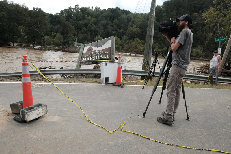
In Marshall talking with Joel and Josh. Very real concerns about the river, which is at ten feet, fierce, and rapidly rising. The island is already under water. At fourteen feet the river would be in town. At nineteen feet there would be extensive flooding and costly repairs.
Our niece Jody arrives at the house. She’s going to do a soap-making tutorial with Leslie for the weekend. We lose power later this evening and with it our water. Cell and internet are also out.
My concern is the wind. The ground is saturated from three days of rain. A windstorm could bring down thousands of trees lining our driveway, the road into town, and the forests that make up 73% of the land in Madison County.
Friday, September 27
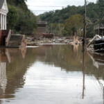
The river crested early this morning at twenty-seven feet, four feet higher than the previous record set in 1916. Yesterday’s concerns are facing today’s reality — the town’s total destruction. The wind never materialized at the house. It’s still raining. Our friend Maia has joined us after being evacuated out of Marshall.
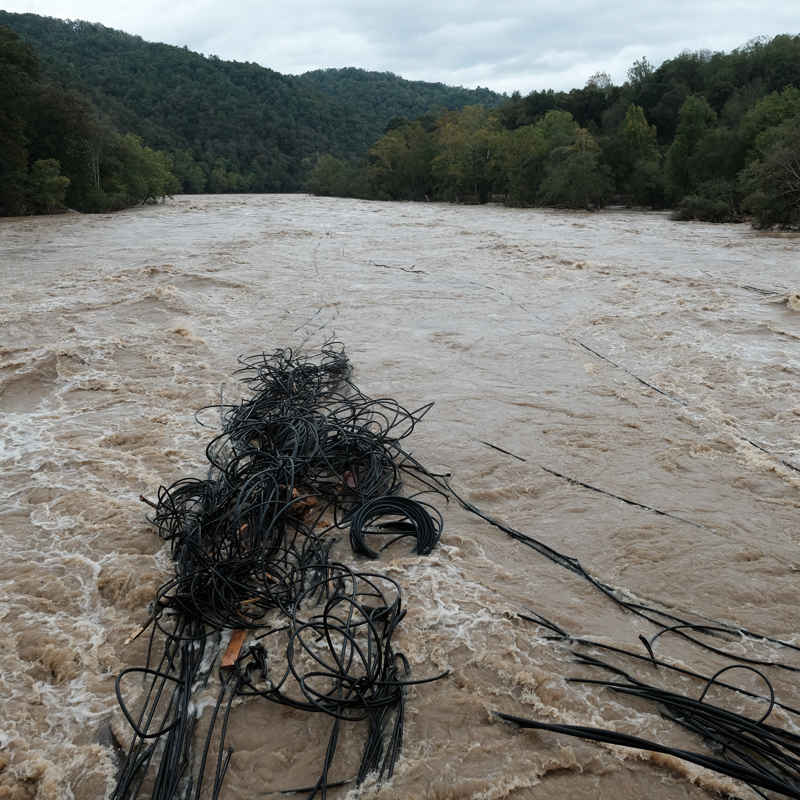
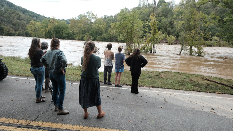
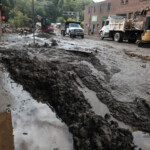
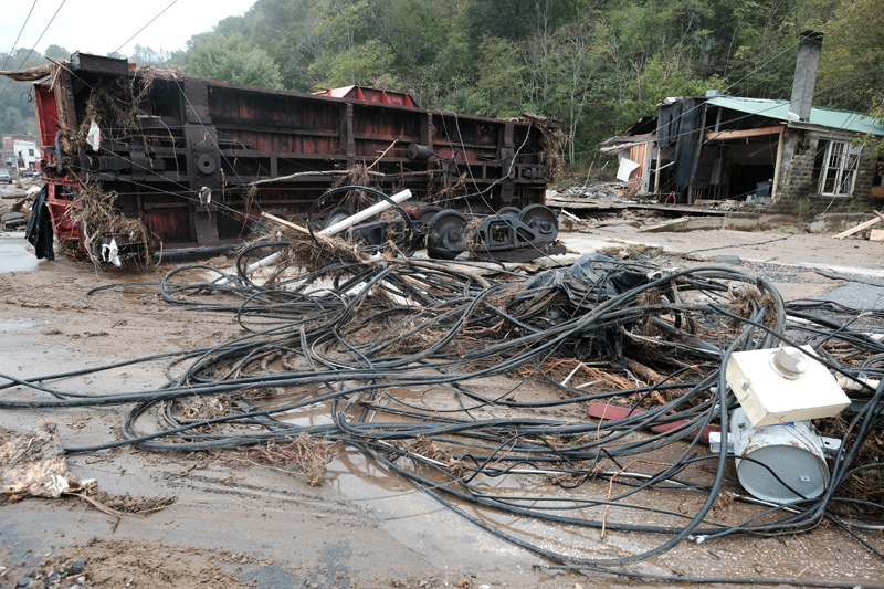
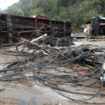
We pile into our car and drive down Little Pine, thinking we’ll go into Marshall. We’re stopped before we get to the Redmon bridge. Neighbors are lining the road looking at the river, which has become one with the road. Fuel tanks, giant tangles of PVC piping, shipping containers — swept away.
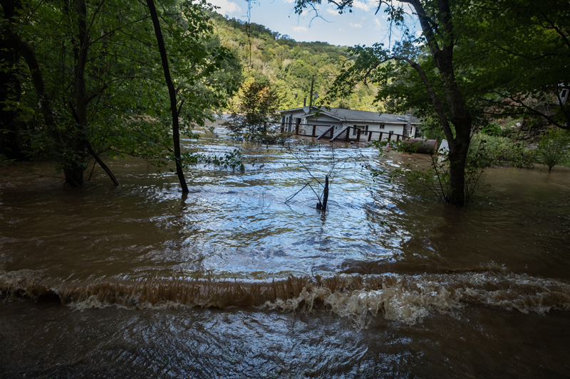
We turn around and drive down Anderson Branch to Barnard. There, worse. Over five feet of water covers the road. Ronnie Meadow’s house inundated. Neighbors wading waist-high water to get his prescriptions and photographs.
Stop at Paul and Laurie’s and get water from their spring. Go home and start cooking and the power comes on. Internet and cell service spotty.
Saturday, September 28
Drive down to Barnard to see if we can get out, and do. Stop at the bridge. Meet some neighbors, make some pictures, come home. Chris, Maia’s boyfriend, got in from Atlanta. We make supper.
Sunday, September 29
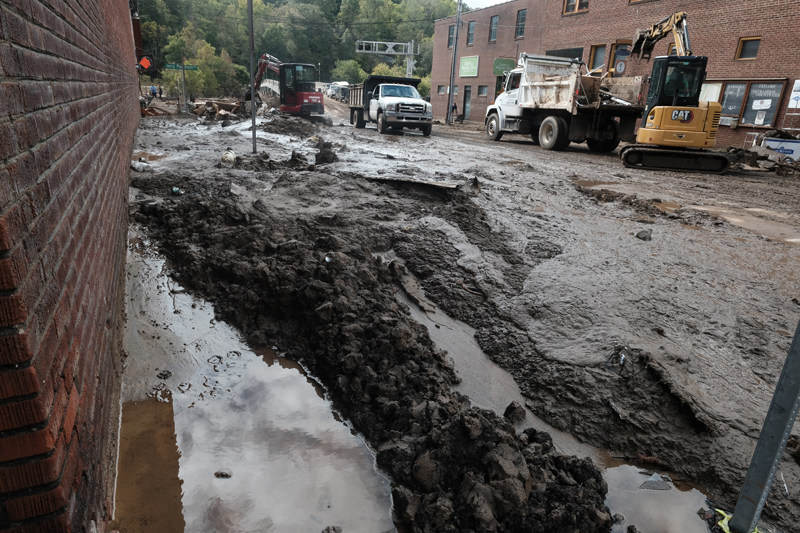
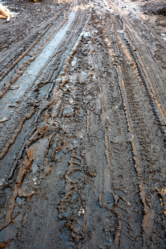
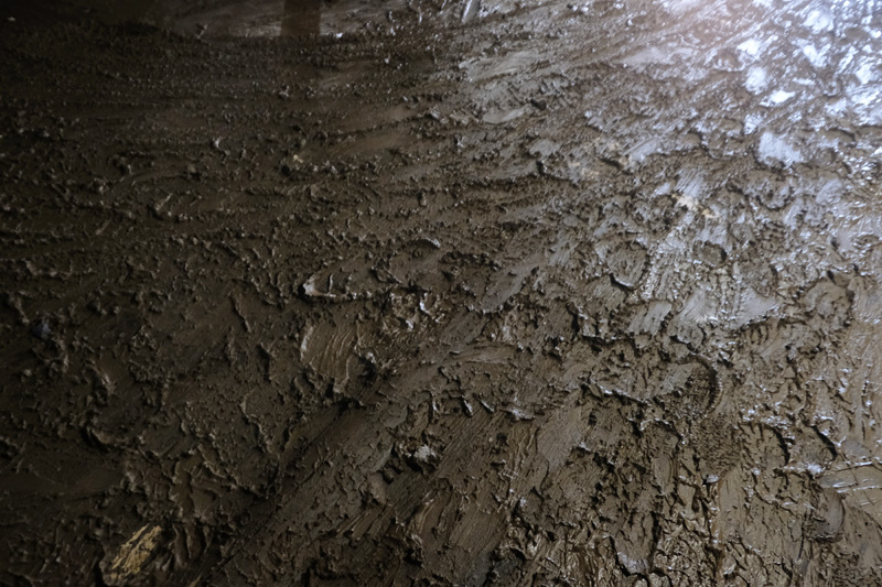
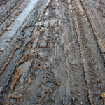
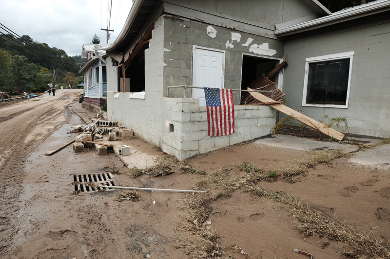
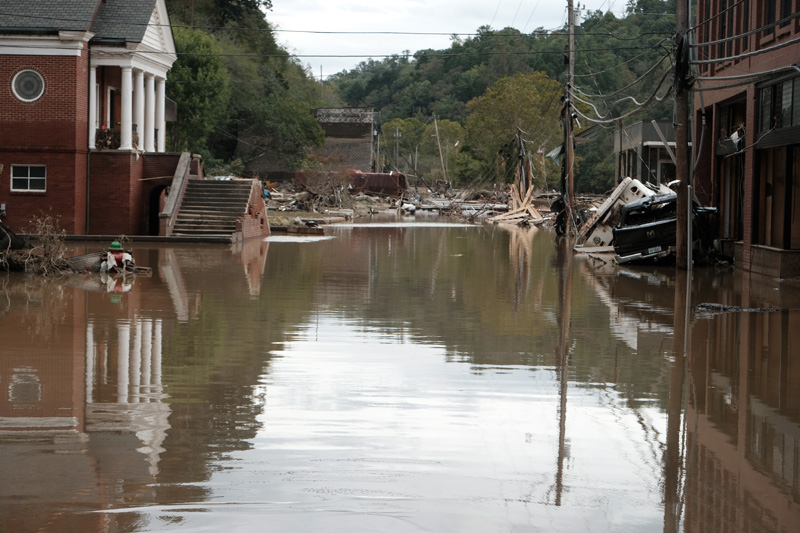
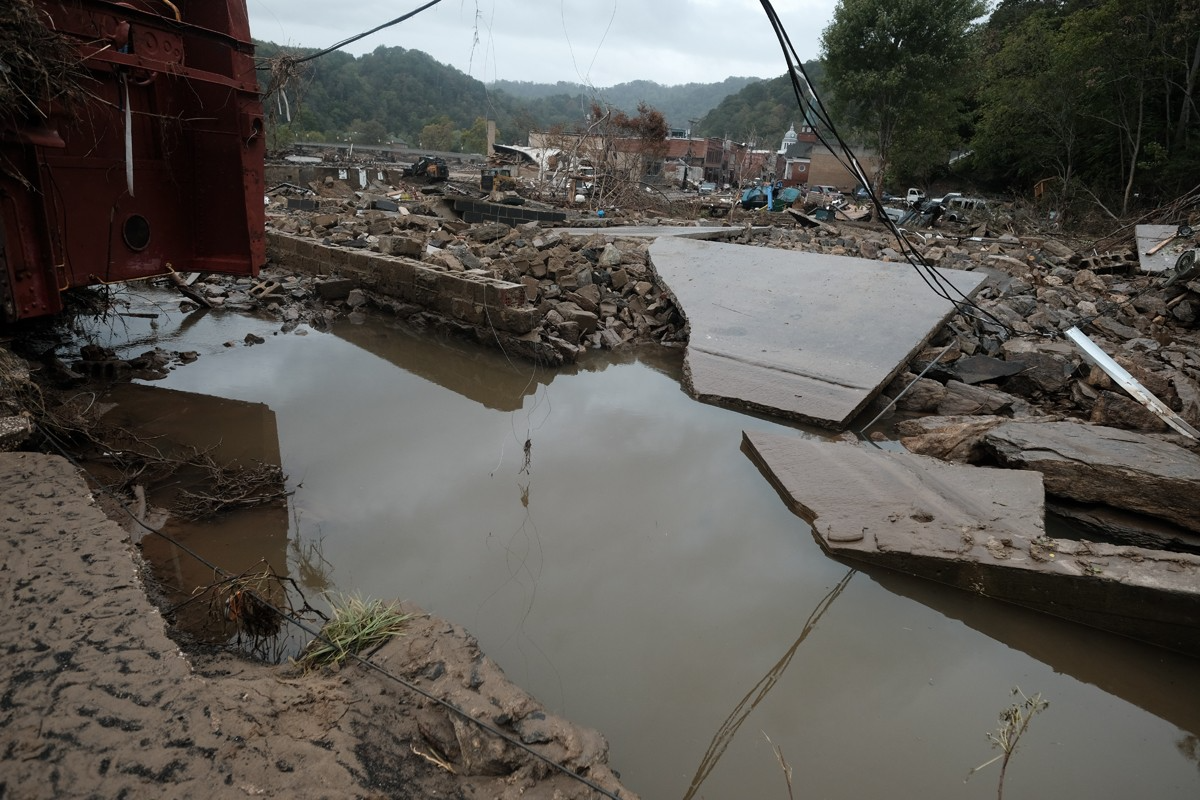
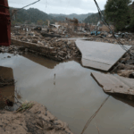
A first look at Marshall. The mud. Everywhere, impossible to avoid. Heavy, sticky. The kind of mud that sucks you in and holds you close. The beginnings of debris piles. Submerged cars and trucks. Rubble where buildings once stood. Stores and restaurants where we’d visited just days before, windows broken, spewing mud from their orifices. And the smell, a mix of water and mud, and propane, a general sense of toxicity.
This is the fourth hurricane related flood I’ve photographed in the last twenty years — Katrina in New Orleans, Hugo in South Carolina, Floyd in Eastern North Carolina, and now, Helene in my backyard.
There are similarities between the four. The mud. The displaced buildings and houses and subsequent debris fields. People’s faces and eyes, at once unbelieving and resilient.
But this is different. It is home, it is friends, neighbors, it is music and dancing, it is church if you want, art most everywhere, eccentricity abounding. It is gone.
I see Morgan, in the midst of mud and debris. Forlorn. No doubt realizing she’s lost her job to the flood. We hug. I move on.
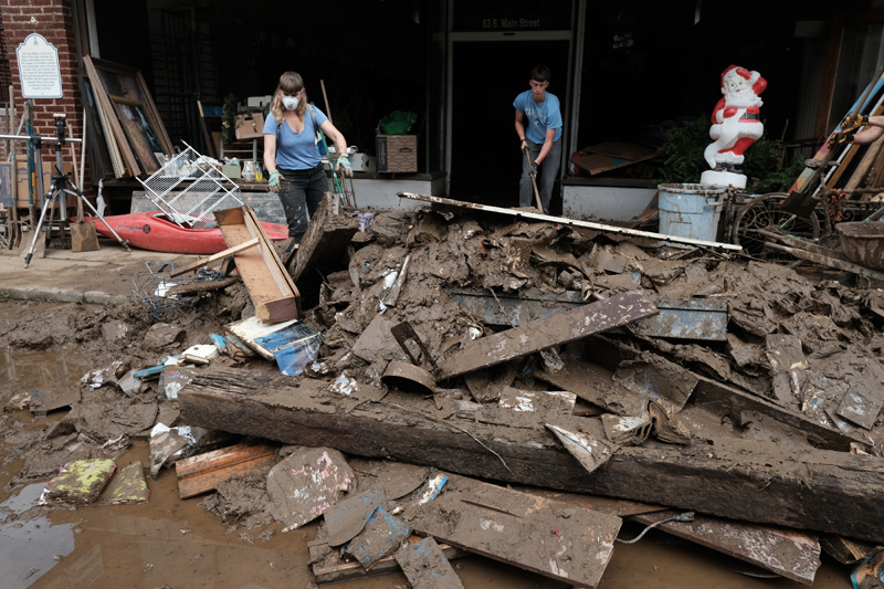
The uniqueness of each building has taken on a sameness of look. Broken windows, water lines above the doorways, stuff beginning to line the street — books, chairs, a sewing machine, an elk head, furniture, boxes of dripping files in front of a lawyers’ office — and mud.


Monday, September 30
For many people, town residents and storeowners, this is a first look at the town, their places of business, their homes. The shock is palpable. The enormity of the destruction incomprehensible and impossible to accept. There’s tears, many, and embraces. What else to do? It’s a reckoning of what once was and what it has become in the blink of an eye. And what lies ahead.
Western North Carolina has long been considered a climate haven. The Southern Appalachian mountains are among the oldest on earth and they offer protection from tornados and hurricanes and other natural disasters. We’ve had floods and landslides in the past, and memorable snowstorms, droughts, and fires. But Helene was unique and has been termed a “geological event” because the accompanying flooding, landslides, and tree damage will have a lasting impact on the landscape. It certainly has had a lasting impact on Marshall and the twenty western counties of North Carolina.
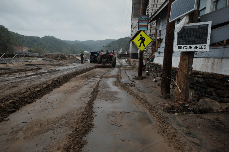
I walk through town for three or four hours, making photographs, talking to friends and neighbors. I think about shoveling mud, but feeling how dense and heavy it is, I realize that it’s a heart attack waiting to happen. I’m clearly the oldest person out there and the work is for the young.
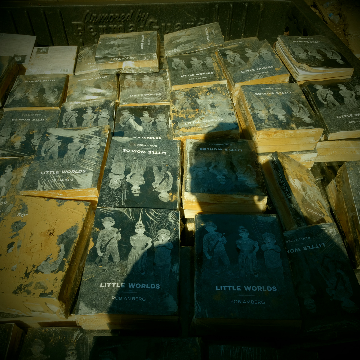
I went to check on my books — 450 copies of my new book, Little Worlds —that were stored in a friend’s warehouse in town. The road in front of the building is foot deep in mud but seems firm at first step. With the second I am shin deep and locked in place, unable to lift my feet. John and Kirsten pull me out, sans shoes, which Kirsten pulls out by laying flat on the ground.
Tuesday, October 1
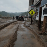
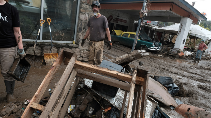
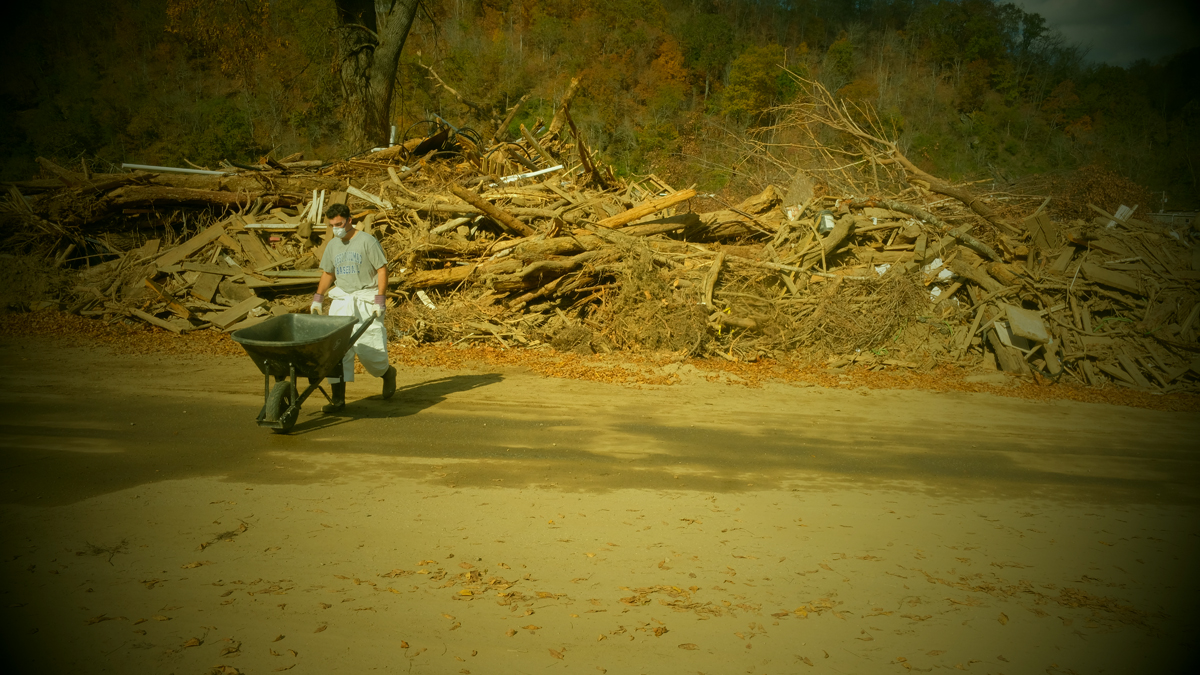
There’s more people in town today, beginning the task. Some are clearing buildings, adding to debris piles. Others are shoveling and scraping mud. Some are salvaging what little there is to salvage. There’s heavy machinery and a steady line of dump trucks heading to the landfill. The mud remains slick, never-ending, clinging to whatever it touches.
I talk with Jamie Smith and his wife who own the French Broad Exchange, our local used bookseller. They’ve lost over 15,000 volumes to the flood, almost their entire inventory. They’re older, of retirement age, and questioning a return. They don’t own the building and the owner is reluctant to commit to doing any repairs.
At Penland & Sons Store, the interior looks like a giant has gone in with huge salad forks and stirred the contents — clothing, books, jams and jellies, fresh vegetables. Georgette takes me to a moveable counter with two baskets of my wife’s soap resting on top. The flood lifted the counter to the ceiling and rested it in a new location in the store, never disturbing the soap.
With help from Todd I make it into the building to check on my books. It’s dark inside the warehouse, the floor carpeted with mud and water, tools, lumber. Two-by-ten boards have been placed throughout the building and we walk gingerly to the back. The pallet of books has been moved and is resting on its side in a puddle of water and mud. The covers appear untouched, protected by the cellophane covering. But when I cut into the pallet and pull out a small bundle of books, I see they are all sealed shut, only opened by tearing pages. Disheartening.
Wednesday, October 2
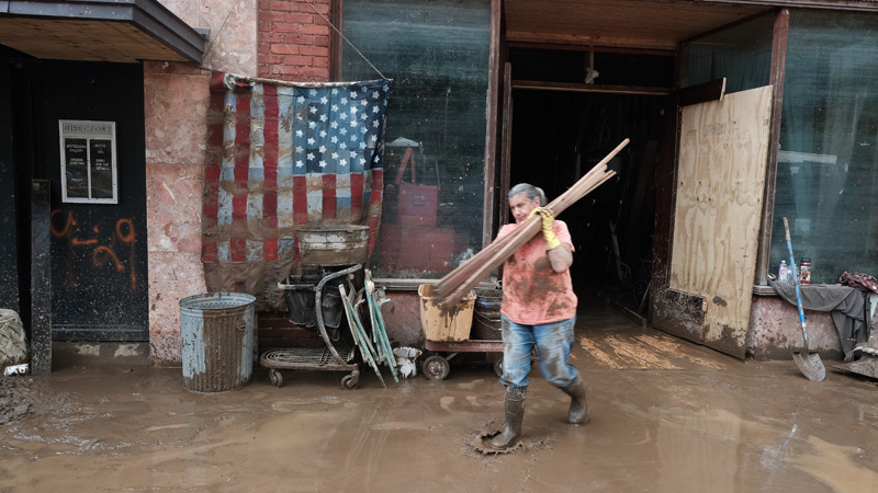
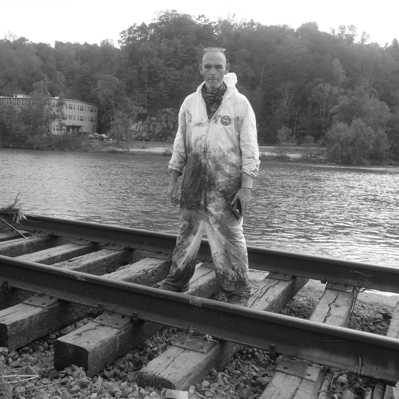
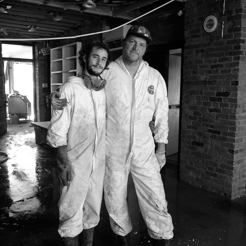
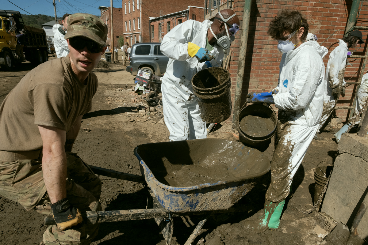
Staging ground has been set up at Nanostead on the Marshall bypass and it is immediately flooded with supplies, equipment, food, and volunteers. The volunteers are coming from all over and they are a diverse group — church groups, college students, elderly retirees, and county residents not impacted by Helene. They don Tyvek suits with boots, gloves and respirators as there are concerns about the toxicity of the mud. They’re shuttled into Marshall in the back of trucks, their gleaming white outfits blinding in the sunlight.
The town is a hub of activity. I’m reminded of stories about Marshall before the coming of I-40 and the bypass. Then, it was on the most direct route between Knoxville and Asheville. This small mountain town had three car dealerships, three grocery stores, two hardware stores, two florists (Sunnyside and Shadyside}, a library, the courthouse, countless attorneys, the jail, and restaurants and general stores.
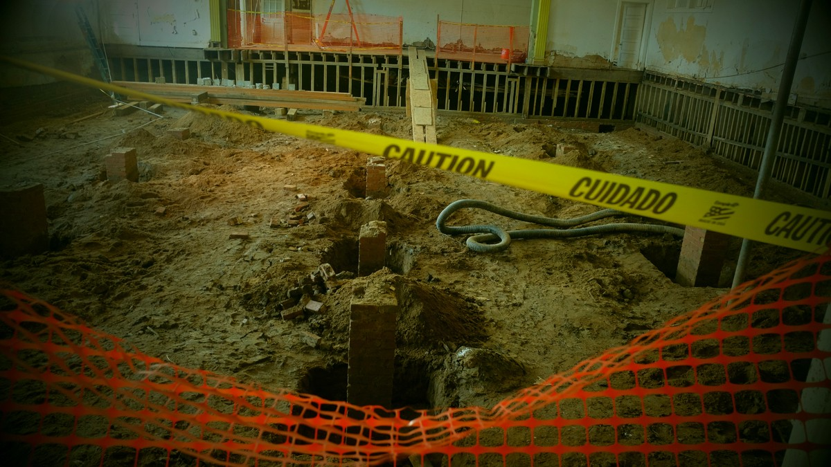
Now, the streets are crowded and dangerous with an abundance of heavy machinery — track hoes, front end loaders, bulldozers — all piling and loading a steady stream of dump trucks, some with mud, others with debris, and still others with remains of trees. Smaller tractors with scrape blades try to keep the mud at bay.
Inside the buildings the owners, along with friends and volunteers, push and bucket mud into the street. The concern now is mold. A series of warm sunny days heightens the fear. Piles of soggy, stinky, just plain nasty, insulation and sheetrock begin lining the street.
The mood is different today. The townspeople remain depressed and angry. But I also sense an adrenaline rush, a feeling of resilience and determination to rebuild. Perhaps it’s the volunteers, the added hands and young energy. Or the visible evidence of the recovery moving forward. Or how the town is working together.
Food stands are set up to feed the workers. Water. Washing stations.
There is a town meeting every evening. An accounting of what was accomplished that day. How many truckloads of debris. The number of buildings mucked out. And also plans for the next day. Who needed what? What could be improved?
The town is shut down after the meeting. No power, no water, standing water throughout, massive and growing debris piles. Ghostly. Police patrol the streets at night. There has been looting.
Thursday, October 3
After the storm hit and the level of destruction to our region became evident my ex-Catholic guilt kicked in. I thought my book, Little Worlds, which speaks of a worldwide collapse, had somehow caused the flood. I could hear myself in confession — “Bless me father for I have sinned. I wrote a book that predicted an apocalypse and it came true. I’ve ruined a town and the lives of many people.” But, soon, I realized that, unlike the federal government of Marjorie Taylor Greene’s imagination, I could not control the weather.
But at the same time, both Leslie and I are experiencing survivors’ guilt; the knowledge that we faired well in the storm compared with friends who’ve lost everything. Yes, I lost a lot of books, income. seven years of sweat equity. But the books can be replaced. And a look around Marshall, helps me understand I’ve lost very little.
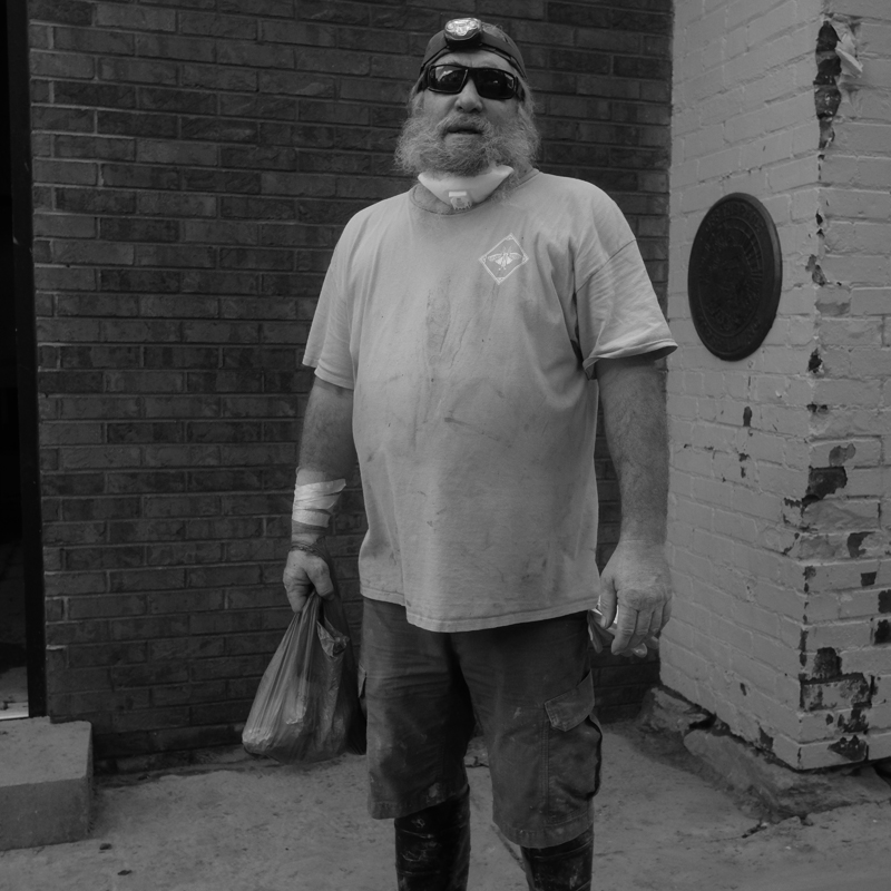
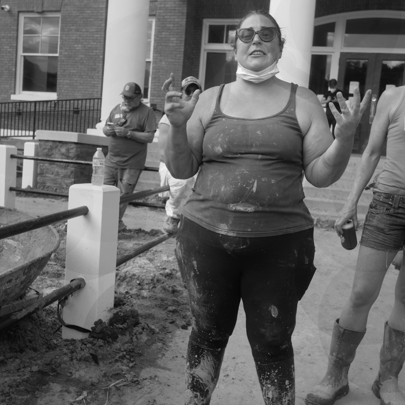
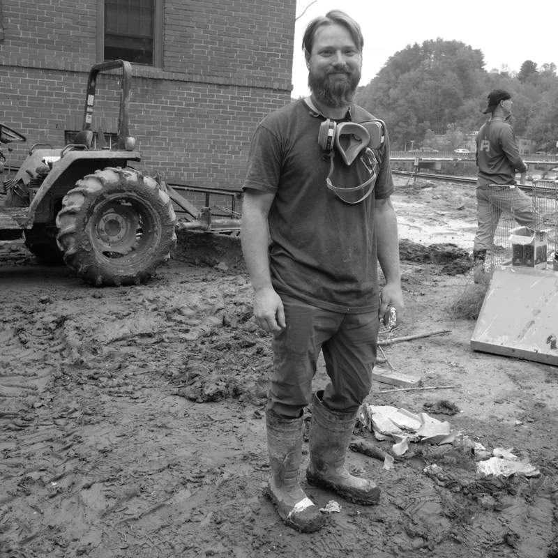
Shooting portraits today. Square format, b/w. Tight. Faces. Some objects. The black and white takes me back to my beginnings in photography and my belief that color can be so distracting. The monochrome heightens the emotions.
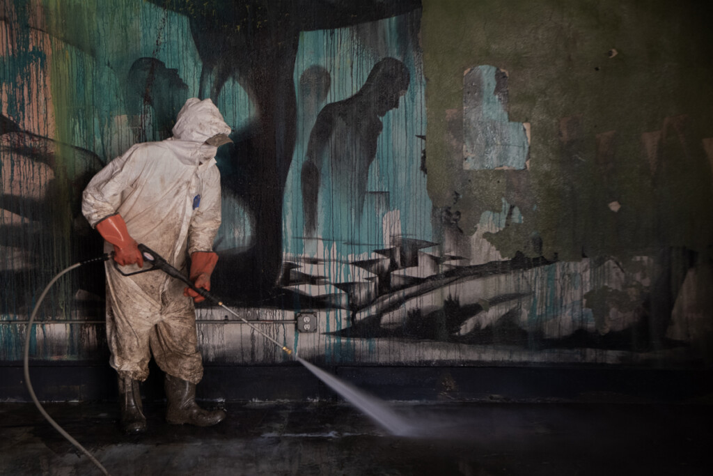
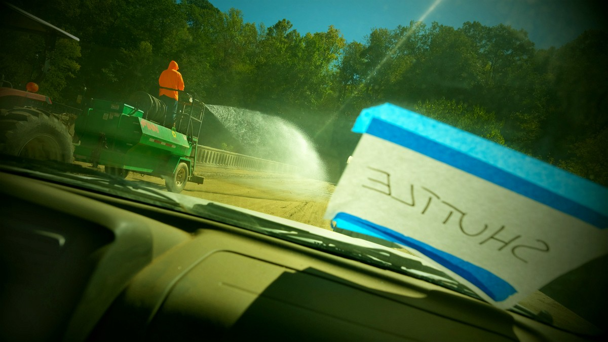
One of the real ironies of this catastrophe is water. The tremendous amount of water that flowed through town to cause this level of destruction. And now the tremendous amount of water being used to rid the town of what the flood left. Pressure washing — walls, floors, machinery, salvageable items.
As I walk through town, doorways seem to vomit debris. The piles of rubble, cinderblocks, and brick remind me of a walk with my son through the Valley of the Temples in Agrigento, Sicily. Some of the twenty-five hundred year old Greek temples had been meticulously restored to mimic their one-time magnificence. Others were mounds of crumbling limestone columns, left where nature had placed them. Both here and there, in Marshall and Sicily, I see fractured memories of what once was.
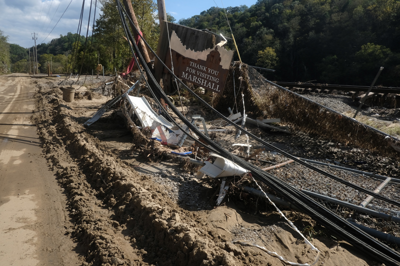
Cars looking like relics dug from a different era. A telephone pole perches over Main Street, hanging by the wires that it once supported.
At Penlands Store, Georgette and Susan and their families sort through mounds of water and mud-soaked pants, shirts, dresses, scarves, hats, belts, boots. Trying to lighten the mood of despair, I jokingly ask Georgette if she has a 42-long sport coat. She gives me the finger.
My books have been moved to the upper floor of the warehouse, in the dry and out of the way. I can see them for what they are, and are not. What they are is artifacts, remnants of the great flood of 2024. The covers are readable, clean. What they are not is useable. The pages are glued shut, only opened by tearing. There looks to be 350 of them.


Friday, October 4
The town is crawling with journalists, photographers, videographers, all looking for the defining image or story. Some are working with major publications or media outlets, others are rubber-necking, disaster tourists. All are afraid to get close, to engage, choosing to keep their distance with their long lenses and removed personalities.
Volunteers are here in earnest today, hundreds of them. Arriving to Nanostead, the staging area, and donning brilliant white Tyvek and boots, heavy gloves, masks and respirators. They’re driven by shuttle into town and turned loose. Students from all over, elderly people here with church groups from Oklahoma, California, and Louisiana with memories of Katrina. A soul food truck operated by a family from Florida who stay a week and then have to beat it back to Florida to help with Hurricane Milton. The best fried catfish I’ve ever eaten. Other trucks arrive in regular fashion, bringing food, water, chain saws, generators, more Tyvek.
Throughout the day I see people — hugging, holding hands, crying together, hugging some more. The look remains one of disbelief, confusion, anger, emotional exhaustion. Yet, people are here — together — mucking, hauling debris, ripping out sheetrock and insulation, helping each other. I see my friend Matt, a local building contractor, who sends a crew down to the Natural Foods store where they demo the sheetrock and insulation throughout the store in ninety minutes — a job that would’ve taken the owners days to finish.
Sunday, October 6
There are fewer people in town today and I don’t stay long.
Deb and Jerry Burns at Engine House Design are mucking and removing debris but already thinking about how to redesign the building.
Jamie at French Broad Exchange isn’t sure what he’s doing. The buildings’ owner is not helping with the clean-up and restocking will be a long, slow and expensive process. But he loves the town and being part of it.
Josh has a small crew pressure washing the kitchen at the Old Marshall Jail. I’m mesmerized by their movement with hose and brush, like an elegant dance of light and space. And for a time I dance with them, moving, seeking the right spot, stopping time.


Tuesday, October 8
The town is humming with activity today. Food stations at Nanostead preparing for the noon rush. Downtown, mud remains the ever-present problem. Inside the buildings, pressure washing and sweeping the liquid muck into the street, where it will be piled, picked up, and hauled off. There is a sense about the mud that it will never go away, as if it’s been imprinted and will forever be a part of the town.
There are some buildings, farther along in their rebuild, that have fans set up in their open doorways, drying the building and clearing the air.
There are more volunteers, their gleaming white Tyvek soon to turn brown. They’re mostly young, many students, some from close by, others from far away. It’s heartening.
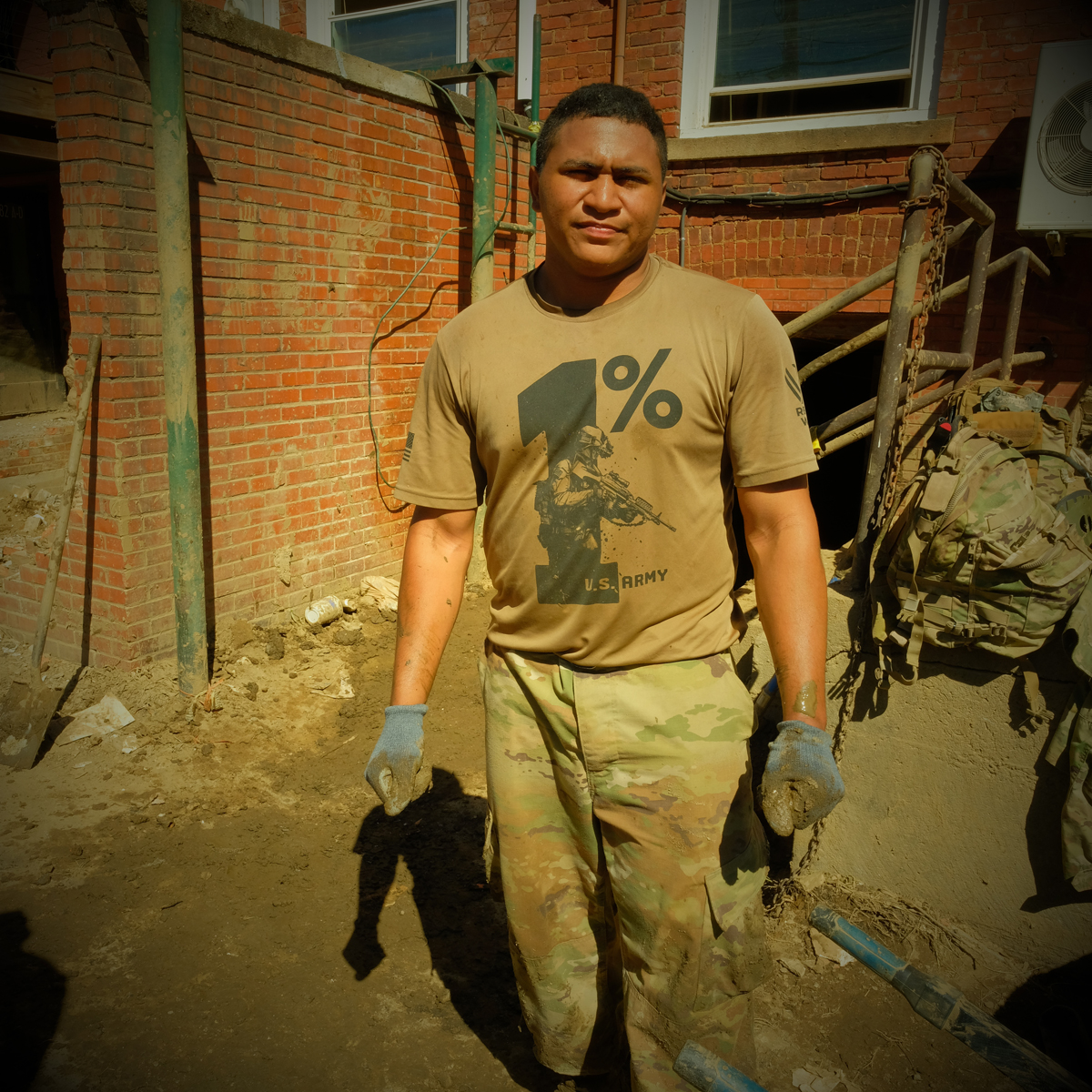
And the Army has arrived. Probably a couple of platoons of men and women from the 101st Airborne Division from Fort Campbell, Kentucky. They, too, are very young, some not long out of high school. Fit, with shoulders and arms meant for work.
I walk through town hunting artifacts. They’re everywhere. Still-life expressions of what once was.
Wednesday, October 9
The Army seems to have found its purpose in the basements of downtown Marshall. In those tight, low-ceiling, airless dungeons, up to three feet of river mud has settled. In most cases the only access to the basements is through suspect steps and narrow doorways with no room for machinery.
I have a long history with the Army. My father was a veteran of World War II and both of my parents worked for the Department of the Army throughout their careers. I was an Army enthusiast and went to an all-boys, Catholic, military high school. I considered a career in the military as a potential life goal. I enrolled in advanced ROTC in college and was preparing to enter the Army as a second lieutenant upon graduation.
But change happens if you are open to it. I began reading a broader body of history and literature and hanging out with a more diverse group of people (teachers and students) who introduced me to new ideas and ways of seeing the world. A trip to Italy with my grandmother sealed my distaste for Catholicism and opened me to European opinions of America.
So, when the 101st Airborne marched into Marshall, I was prepared to be resistant at worst, mistrustful at best. But change happens.
At the Madison County Arts Council building, a crew of fifteen soldiers are gathered around the stairs and doorway to the basement. A group of six or eight of them, two mud buckets each, go into the dark, dank room and begin shoveling. The mud is thick, heavy with water, and stinks; a half a bucketful is almost too heavy to lift. At the doorway stands Lopez. He handles all the buckets, hauling them to the stairs, and handing them to two men above him who empty them into wheelbarrows. It is grueling, nasty work. They work in thirty-minute shifts, a fifteen-minute break, then back at it. It takes two days to clear the building.
There is a side of me that is in awe of these young men and women — their focus, work ethic, stamina, and their ability to find the best solution to a problem and then just doing the work. At the same time I know that when they signed up for the Army they didn’t really have a choice as to what work they did. And I much prefer they are in Marshall, rather than in some far away place shooting up the local population and countryside. The whole town is thankful they are here.
Friday, October 11
The river’s flow looks almost normal today. Nothing else about it is the same. New channels and sandbars. The river banks are stripped clean or a tangle of downed trees, miscellaneous debris, and a gelatinous mix of sand and mud. There’s a shipping container wrapped around one of the bridge pilings. Those trees that survived the flood are festooned with plastic sheeting and bundles of PVC pipe.
The Army and the volunteers are back at it, but roles have changed. The soldiers have been ordered out of the basements by their superiors for fear of mold and toxicity. They’ve been replaced by the young volunteers.
I wade into the warehouse to check on my books. They’ve been moved upstairs, safe and dry, and out of the way. Sealed shut and unreadable.
Saturday, October 12
Al and I go back to the warehouse and gather the books into the back of my truck. We’re going to park them in our barn for some undetermined future use.
I make a photograph of the books in the truck that speaks to me of the totality of my loss. The image filled with mud-splattered books — black and white and brown. In the corner, looming, is my head and torso’s shadow, the books’ covers living in my body’s trace.
Tuesday, October 15
A late afternoon walk through town. Streets mostly empty of people, not the mud, which maintains a lessened but constant presence.
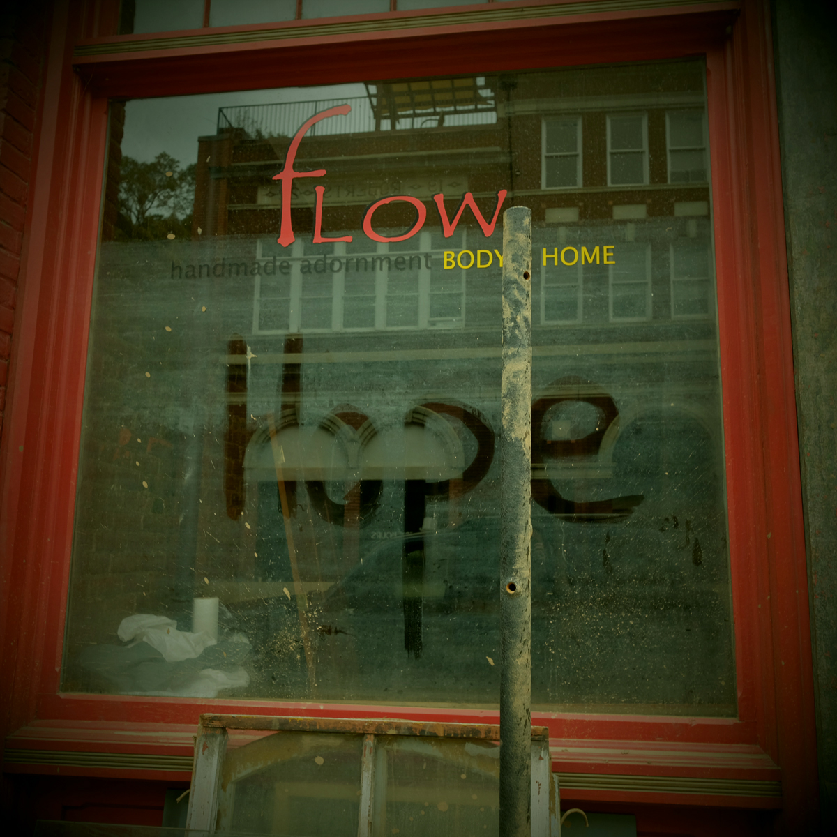
Years ago, when I lived in downtown Marshall, in converted warehouse space on the third floor of what is now the Flow building, the town emptied at 5 o’clock. Dave, the town custodian who doubled as Santa Claus in the Christmas parade, would begin his walk through town with pushcart, shovel and broom. And Marshall would shut down for the night.
This town closure, of course, is different. Involuntary. Streets passable but slick with mud, buildings open to the air, no power, the town not just shuttered for the night, but essentially dead.
But I do faintly hear music and follow it to the courtyard behind the old Rock Cafe. It’s a small gathering celebrating Deb Burn’s birthday. There’s a chocolate cake, and music, and people dancing around a portable heater.
Saturday and Sunday, October 19 & 20
It’s mostly quiet as I walk through town. There’s people, but not many. Thomas and Mark are washing and sweeping, getting ready to mitigate for mold. The Shadyside florist guy is stunned, everything that was inside his store is now piled high outside.
The relative lack of sound, the quiet of the place, offers the opportunity to see quietly, without the urgency of the cleanup dominating most images. There’s time to feel the light and taste the wind, hear the now muffled sound of the river. There’s beauty in the stillness of the destruction, life as the river has left it.
The roads are dusty now, the recurring mud dry from lack of rain. It’s been three weeks since the storm.

Monday, October 21
A quick visit with Georgette and Susan at Penlands Store. They’ve torn the flooring out of the building and I bring some home with me to maybe use in an art project.


Sunday, October 27
Town has become emotionally exhausting for me and I’ve been staying away more and more. The constant reminder of the loss of my books and the utter destruction of the town. Plus, the upcoming election has me and my friends on edge. We’re hopeful Harris will win but not without fear of a bad ending. We know Madison County will vote Republican.
Wednesday, October 30
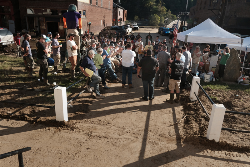
I’m not quite sure how he’s done it but Josh is having ballad swap at the Jail tonight. Balladry has a long and storied tradition in Madison County and the county, especially the community of Sodom, is considered a rich source for acapella ballad singing. Since Josh Copus opened the Old Marshall Jail as a boutique hotel, restaurant and bar, he has been hosting a monthly ballad swap. Six to ten singers, some with multi-generational roots in the tradition, gather at the Jail to swap songs and stories.
It’s pretty much the first event in town since the flood a month ago and the symbolism is hard to miss — the community’s ancient tradition responding to the wrath of our most ancient river, the French Broad.
It's primitive at the Jail, no food, a portable tap serving free beer, limited seating, highly emotional. Everyone is glad to be among other people. Hopeful. Closes with “I’ll Fly Away.”
Saturday, November 2
Meet up with Jack Cecil from the Biltmore Estate and his wife and sister and do a walk around town. He is on the board of trustees for the Duke Endowment, which has donated millions to the rebuilding effort in the region and wants to do more. They’ve asked me to come to their monthly meeting and do a presentation about Marshall.
We walk over to the island for a look at the Marshall High Studios. The grounds — the walking trail, basketball court, swing sets, picnic tables, maybe a hundred trees — denuded and gone. Replaced with debris piles, mountains of trees, and a heavy layer of sand. Inside the building — like every other place in town — but bigger, more complicated, very expensive.
The dust. It’s dry. People beginning to worry about fires with all the downed trees, fuel.
Saturday, November 16
The mud is mostly gone, not entirely, but out of the majority of the buildings and off the streets. Debris and dead trees remain a work-in-progress with any one day better than the day before. Many places have been pressure washed and mitigated for mold, swept, and open to the dry air outside.
The town has been feeding on a shared energy to get to this visible progress and today is the expression of that bursting energy. Party is in the air. Not quite two months since the flood and Marshall is ready to cut loose, take a break from the doom and gloom, catch our collective breath and ready ourselves for the next, hardest push.
My friend Lois, a fellow artist and thirty-year resident of the county has decided to have her annual found art fashion show. Lois lost everything to the storm—her home and studio, and every trace of her seventy years of life and fifty years of art. Her response to the grief of losing the physical memory of her life—make more art.
I photographed Lois’s first fashion show at the Madison County Arts Council and many more since then. Funny, outrageous, creative, the shows take full advantage of the overwhelming number of artists in the community. This year is no different in that respect—a celebration of the power of art, and resilience. This year's theme — Tyvek.

Spring, 2025
I think about Helene a lot. Was this our “Get Right With God” moment? Retribution for past sins? Noah? Or was it a random, freak-of-nature storm that devastated the western third of our state. Was nature humbling us? Letting us know that while we consider ourselves safe from most of nature’s fury, it isn’t a sure thing. When I think about the frequency and intensity of these natural and manmade disasters in places like Paradise, California, Maui, Hawaii, Gaza, Ukraine, Los Angeles, it may simply have been our turn.
The adrenaline wore off months ago, about the time winter set in. It carried the town through the intensity of the cleanup — the mucking and striping and pressure washing and mitigating. There is still evidence of the recent destruction — lingering piles of debris, or trees, or mud — but Main Street is clean, drivable, and gives the appearance of nothing being amiss.
But peoples’ moods have darkened with the season; money to rebuild being the main concern. Insurance monies are slow to arrive and federal dollars that flowed quickly during the previous administration are being delayed or rejected by the current crowd in office.
People sit and wait and get frustrated.
Also there’s a shortage of sub-contractors with the entire region devastated. Plumbers, electricians, carpenters, laborers, heavy equipment operators, all hard to find.
Major questions about the rebuild of the town, which lost over a quarter of its buildings, and still lies in the floodplain, something that won’t change. And there is the very idea of the town itself — what is it, who is it for, how is it paid for?
Marshall has been reborn in recent years. What had been the economic, political, and cultural hub of the county for many decades had mostly died during the 1980s and 1990s with better access to the outside world and changing demographics. The 2000s brought new money, ideas, and energy to town and Marshall and the county emerged as a destination for art, cultural tourism, and outdoor adventure. The flood changed all of that.
Some people/businesses will leave. Some will stay. Of the original businesses in town, Penlands Store, Shadyside Florist, maybe Bowman’s Hardware, the VFW building, will stay. Every other business is new within the last twenty-five years and most of them are coming back.
I continue walking. Often through town looking for traces of improvement, or not. There are places in town where it looks like the flood happened yesterday, and others that are open for business. I went with Jim along a stretch of the railroad track near Redmon searching for debris and was not disappointed. Same in the woods and field next to Ronnie Meadow’s house.
There are gatherings in town. Mal’s bar has opened for music a few different times and there was a big Punk concert at the Arts Council. The venues are unfinished, almost primitive, without plumbing, but offering a place to come together. Everyone is hungry for it.
Summer, 2025
Was speaking with Pete the other day and we agreed that town felt different. And we couldn’t really say what that difference is. The physical changes are obvious, but beyond that, the emotional and attitudinal shifts areharder to identify. It seems the overall, never-ending need for money is dwarfing the strong sense of community that existed before the flood. And the uncertainty of what is coming next, knowing Marshall will be altered, possibly shattered beyond repair.
As I’m finishing this essay, I must acknowledge several of the catastrophes that have hit the nation since Helene devastated our region. Fires in Los Angeles and Maui, tornados in the Midwest and Plains, another flood in eastern North Carolina, and the unprecedented high-water disaster in Texas.
Storms are growing in frequency and intensity, with devastating effects on people, the natural world, and property. How to reverse course? How to rebuild? How will governments and insurance companies pay for ever-more-costly reconstructions? Our current national government seems intent on removing itself from the responsibilities of emergency management, leaving it up to the states who can’t afford the costs to clean up and rebuild.
Marshall and our neighboring town of Hot Springs are rebuilding, slowly. People are supportive. Music is regularly happening and a couple of restaurants are open. During the day the streets are busy with construction workers —carpenters, plumbers, electricians —putting the towns back together. There is no safe place. All of us are vulnerable; some people much more than others, but there is no hiding from the fact that we live in a deteriorating global environment. And as the scientists have predicted, it will only get worse. 
About the Author/Photographer
Rob Amberg has photographed and written about western North Carolina since moving there in 1973. Internationally published and exhibited, his photographs are represented in numerous public and private collections. Rob has received fellowships and awards from the National Endowment for the Humanities, the John Simon Guggenheim Foundation, The Center for Documentary Studies, and others. His books include Quartet: Four North Carolina Photographers (2007); The Living Tradition: North Carolina Potters Speak (2009); and his Madison County trilogy: Sodom Laurel Album (2002), The New Road: I-26 and the Footprints of Progress in Appalachia (2009), and Little Worlds (2024). Books and prints are available on his website: robamberg.com. Amberg lives in Madison County, North Carolina.
Donations for Marshall’s recovery can be made to:
The Madison County Arts Council
The Downtown Marshall Association
]]>
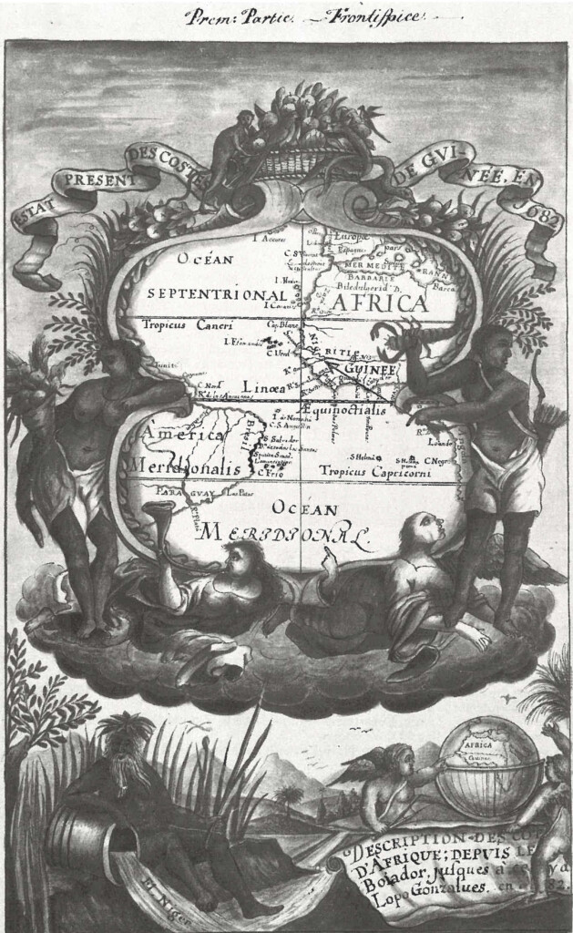
What happens when we put Black Studies in conversation with the history of cartography? Katherine McKittrick, one of the key thinkers in Black Geographies, answers this question in a foundational essay when she writes that “Transatlantic slavery…was predicated on various practices of spatialized violence that targeted Black bodies and profited from erasing a Black sense of place.” As a result, she notes, “Black diasporic histories are difficult to track and cartographically map.”1Katherine McKittrick, "On Plantations, Prisons, and a Black Sense of Place," Social & Cultural Geography, 2011, 12: 948.Black Geographies as a subfield emerged in the 2000s to reckon with McKittrick’s argument, mainly, the ways histories of Blackness axiomatically raise questions of free and restricted movement; territorial boundedness and segregation; and fugitivity from the earliest plantations to the present-day prison-industrial complex. For McKittrick, the structural histories of racial disenfranchisement, plantation slavery, and the “relational violences of modernity” collectively necessitate that we consider the diversity of what she calls “alternative mapping practices.” By this she means attending to the spatial organization of maroon communities; hidden escape routes used by those fleeing slavery, as well as the frequent disguising of these escape routes in music and song; and family and genealogical maps maintained by those who had no legal or citizenship status. In this sense, Black Geographies fundamentally asks what may count as a “real” map and, more importantly, what forms of power and privilege the designation of “map” bestows on the objects it labels. Pushing this point, cartography historian Matthew Edney goes so far as to argue that “there is no such thing as cartography.”2Matthew H. Edney, 2019. Cartography: The Ideal and its History (Chicago: University of Chicago Press, 2019), 1.Edney instead frames “cartography” as an exercise in aestheticizing and naturalizing relations of power; an idealized performance of racialized and colonial hierarchy enacted through its material output, the “map”. Edney’s observation carries special resonance for histories of Black cartography, where scholars have often framed the historic relationship between material cartographic objects and Blackness as an almost axiomatic opposition. And with perhaps good reason: looking at the cartographic archive of the slavery-era Americas, one quickly sees Blackness rendered either as an aestheticized form of subservience to whiteness, or as an irritating anti-colonial node to be eliminated.
As an example of how this tension plays out, we can look to this work from 1773, The Layout of the Conquered Maroon Village Called Boekoe, by Dutch cartographer Juriaan François de Friderici. It depicts the layout of Fort Boekoe, a fortified maroon settlement in what is today Suriname, in northern South America, that was razed by a Dutch militia in September of 1772. The map’s title and aerial-view perspective make it clear that the maroon village itself served as impetus for the map’s creation, yet only as a form of violent erasure: a dialectic that underscores why maroon communities have been such critical points of theorizing for Black Geographies. Yet, also consider the tension Friderici produces in the map’s elaborate title cartouche, held up by a Black figure whose scantily-clad form implicitly references his enslaved status. The figure enacts a colonial fantasy of converting marronage to subservient labor, and here evokes his own subjugation through the map’s material production. Yet, the figure’s equally dominating presence and confident pose also suggest the persistence of maroon life and resistance, even after Fort Boekoe’s seeming destruction.
Black cartographers have long responded to this dialectic of spectacular presence and invisible subjugation that runs through cartographic renderings of Black spaces and places. As one brief case study, in the 1940s, Louise E. Jefferson – a noted African American illustrator and designer – produced a series of works meant to interrogate presumptions of whiteness and the fixity of identity which served as preconditions for depicting the United States as a nation. In her 1945 Uprooted People of the U.S.A., Jefferson depicts abandoned villages, overcrowded transit centers, and internal refugee camps which all emerged because of the dramatic economic and social shifts wrought by the country’s World War II efforts: a depiction of the United States as a country defined by massive internal displacement and populated by what she terms “victims of war.” Her Americans of Negro Lineage, produced the following year, weaves stories and illustrations of Black doctors, musicians, laborers, and politicians together with statistics on Black populations, internal migrations, and the history of slavery.
By recasting the standard political framing of the forty-eight states as an image and icon of the country, Jefferson’s two maps themselves seek new forms of belonging in a nation defined by racial disenfranchisement; and to reckon with how a static map elides the constant histories of migration and identity-making that underly it. In this way, Jefferson’s work responds, perhaps, to one model of Black Geographies that suggests that the visibility of Black histories depends on framing Blackness as “uprooted,” and perhaps in axiomatic opposition to the modern Western nation-state and the material maps which instantiate it. Jefferson’s works provide the impetus to look backward, to ask how Black artists have thought about the history of mapmaking and its relationship to racial formation and especially to racial fixity. Stated bluntly, what demands does Blackness’ inextricability from histories of forced displacement and archival erasure place on those that wish to engage with material maps, a medium that might privilege histories of fixity and boundedness?
I ask this question by looking to the Guia de Caminhantes. Completed from 1816 to 1817, the Guia de Caminhantes (“Guide for Walkers”; hereafter referred to as the Guia), held at the National Library of Brazil in Rio de Janeiro, is one of the few extant cartographic projects completed by a Black artist in the early nineteenth century.
In the Guia’s introductory text, which you see here on the top half of the cover page, its artist, Anastásio de Sant’Anna, identifies himself as an “old” painter of mixed race, and a resident of the city Salvador (also known as Bahia), a major port city in northeastern Brazil where he had long lived and where he completed the work.
The Guia has attracted scarce attention in Portuguese-language scholarship and has never been discussed in English prior to this talk. Yet, it is a rare example of a manuscript map of Brazilian territory produced outside of the context of a military or surveying expedition in the eighteenth and early nineteenth centuries. Far exceeding its somewhat timid title, the Guia is more properly thought of as an atlas, and indeed, potentially the first one ever produced in Brazil: an unbound grouping of thirteen hand-drawn, hand-colored, aerial-view maps depicting, as the work’s cover page outlines, “Kingdoms and Provinces of America, especially of Brazil.” While it opens, as we will see, with a large hemispheric map of the Americas and a map of Brazil, the rest of the Guia consists of eleven aerial-view maps of Brazil’s captaincies (the name for Portuguese colonial Brazil’s political divisions), which collectively detail their rivers, mountain ranges, beaches, settlements, churches, sugar mills, Indigenous settlements, and roads: all landmarks that would be important to any early nineteenth-century “walker” referenced in the Guia’s title.
"Of the Upper Hemisphere of America," Map 1 in the Guia de Caminhantes, 1816. Map by Anastásio de Sant'Anna. Courtesy of the National Library of Brazil. Image provided by the author. 
"Of All Brazil," Map 2 in the Guia de Caminhantes, 1816. Map by Anastásio de Sant'Anna. Courtesy of the National Library of Brazil. Image provided by the author. 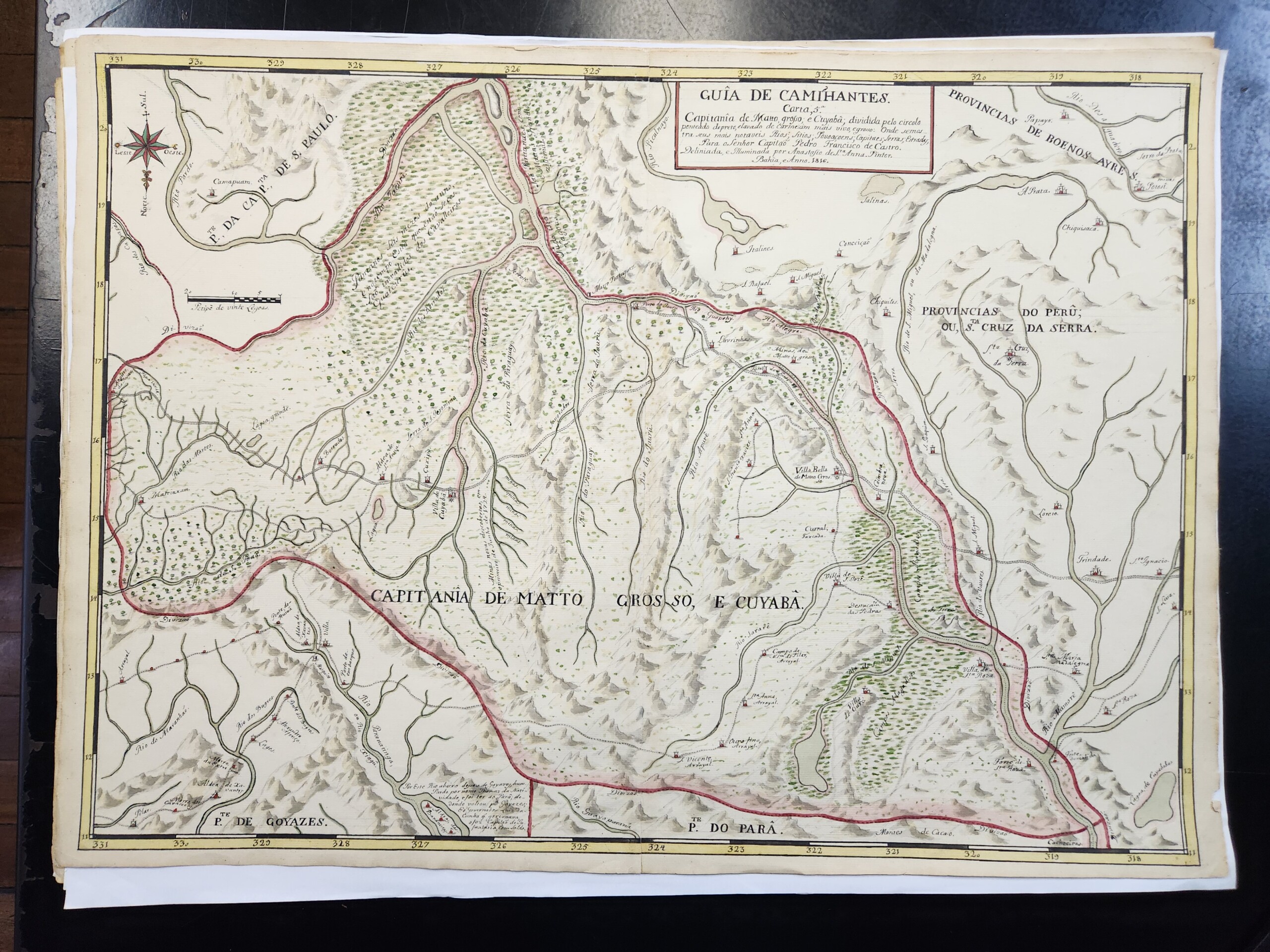
"Mato Grosso and Cuiabá," Map 5 in the Guia de Caminhantes, 1816. Map by Anastásio de Sant'Anna. Courtesy of the National Library of Brazil. Image provided by the author. 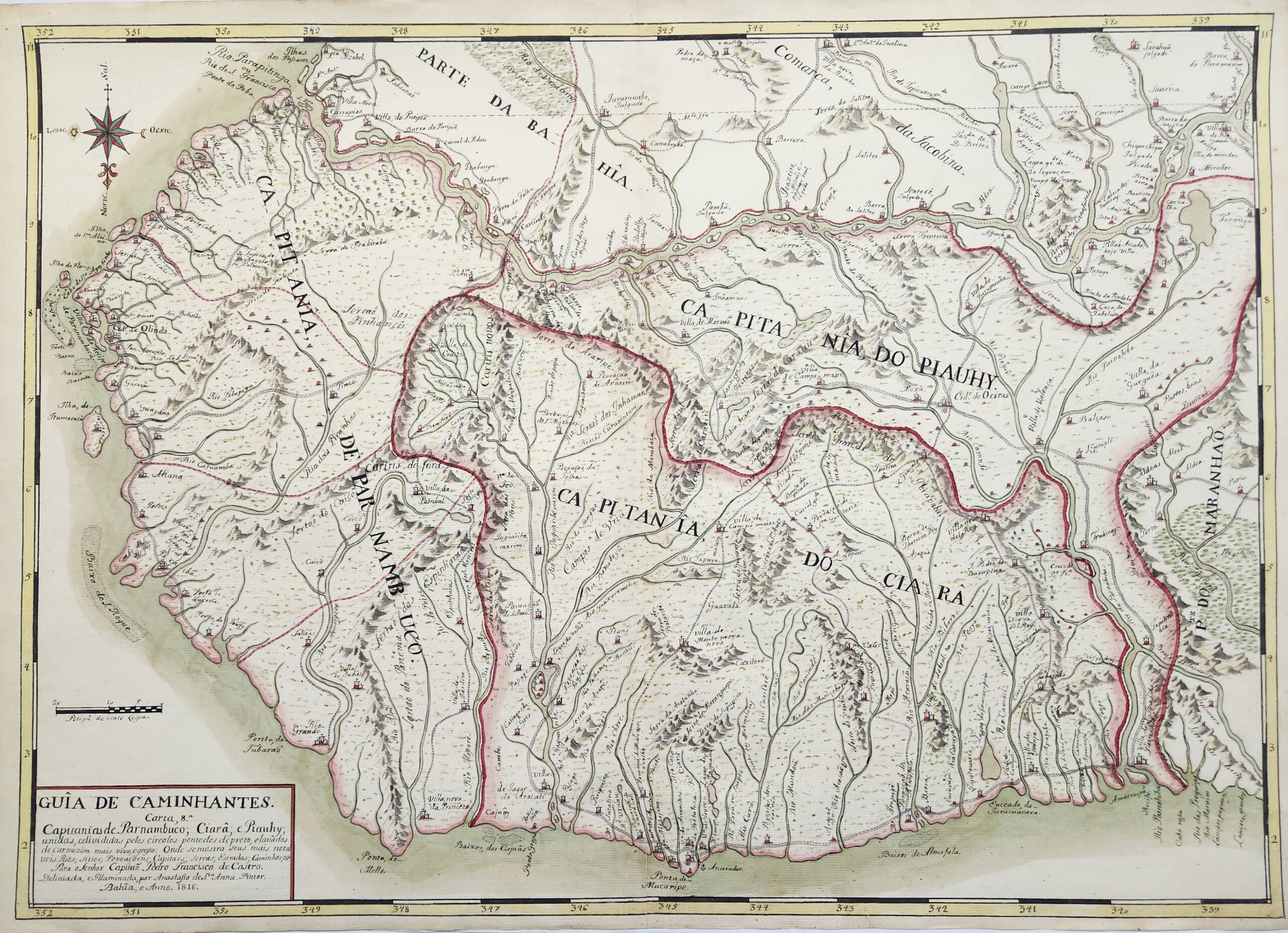
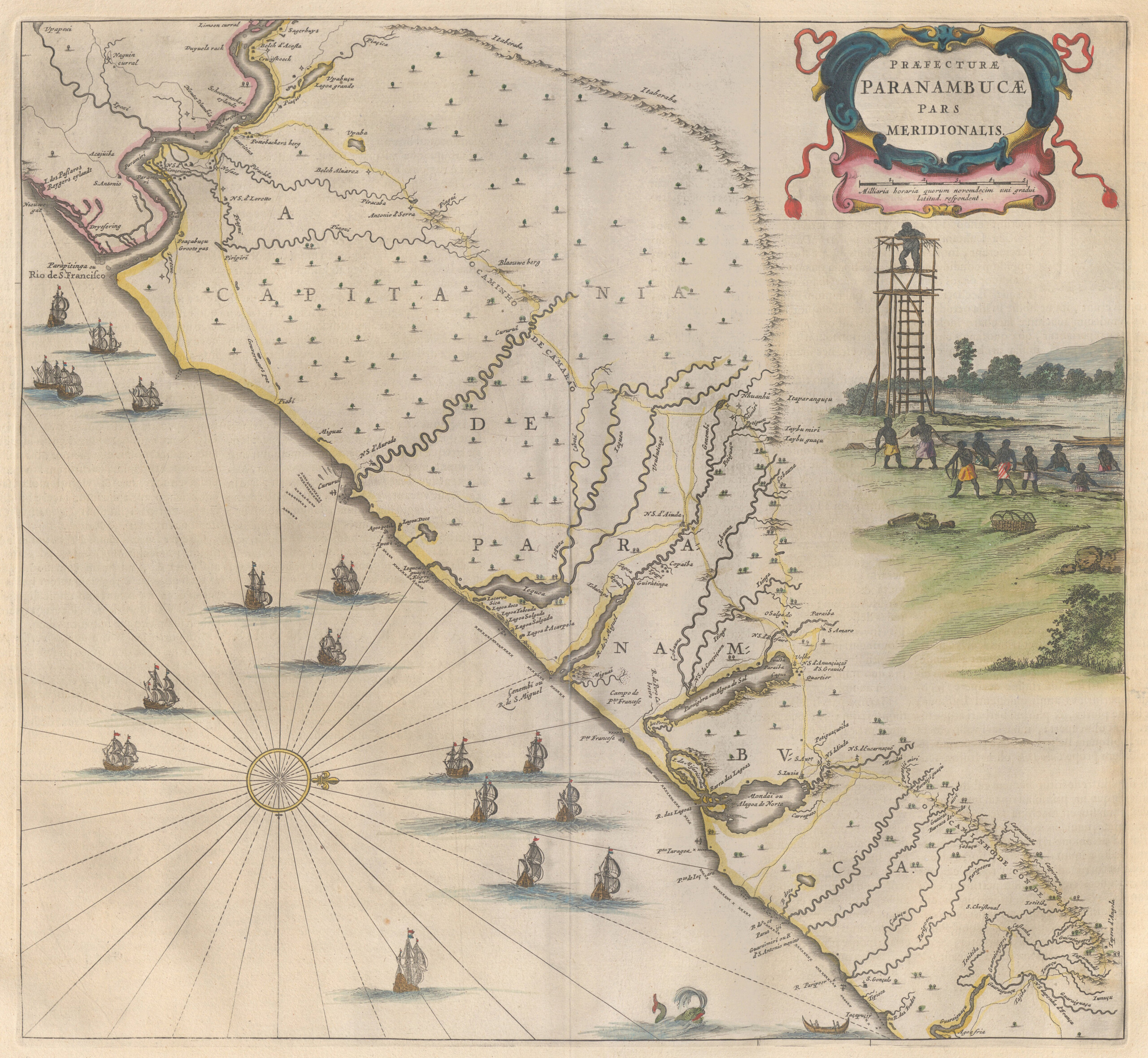
"Pernambuco, Ceará, and Piauí," Map 8 in the Guia de Caminhantes, 1816. Map by Anastásio de Sant'Anna. Courtesy of the National Library of Brazil. Image provided by the author.
The Guia evinces the artist’s intimate knowledge of two centuries of the history of cartography and landscape painting, and these references potently intersect with the social politics around the artist’s racial identity. In turn, as we will see, these maps reproduce and subtly shift conventions of Portuguese military cartography, while also traversing the boundaries between military precision and painterly imagination. Sant’Anna produced, re-framed, and challenged the intersections of empire and racialization in a political and social context in which race strongly stratified—but did not neatly latch onto—the hierarchies of colonial society. In turn, the Guia foregrounds the antiquity and contemporary persistence of Black and Indigenous histories in Brazil and the wider Americas. As if responding to Jefferson’s Uprooted People of the USA more than a century before she produced it, the Guia frames Blackness not as diasporic, but rather as Indigenous to the Americas and in turn constitutive of the modern nation-state. In this way, the Guia starkly contrasts with the maps discussed previously by productively interrogating the opposition of violent colonial cartographies and Black alternative mapping practices. In so doing, it demonstrates how one Black cartographer crafted an intermingled vision of Black, Indigenous, and colonial histories and epistemologies to forge a novel vision of Brazilian national identity on the eve of its independence.
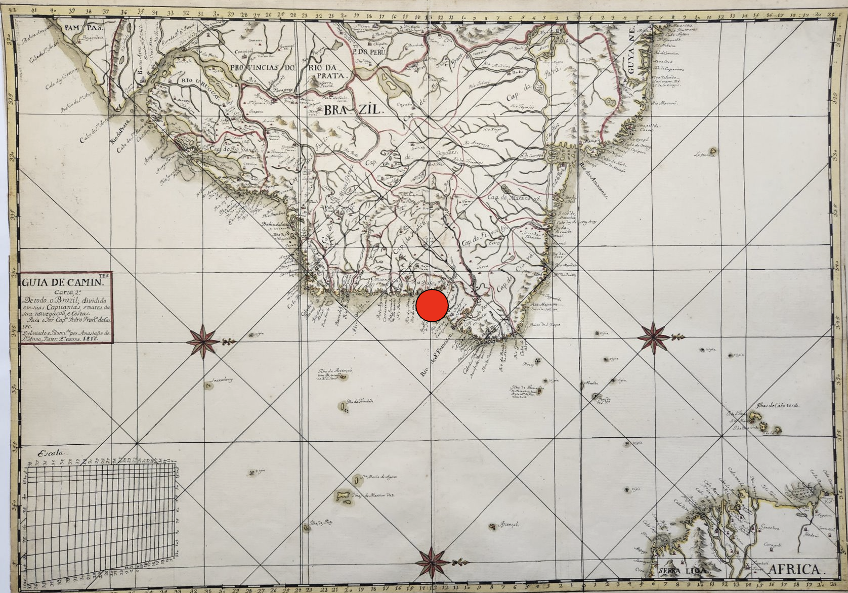
In the Guia’s second map, “Of All Brazil,” Sant’Anna renders latitude with “the city of Bahia” at zero (I’ve indicated Salvador’s location here with a large red dot). The gesture may speak to Sant’Anna’s pride in his home city, but it also testifies to Salvador’s critical political position as Sant’Anna completed the Guia in 1817. Though Salvador had served as the capital of Portuguese colonial Brazil since the mid-sixteenth century, the city had been relegated to secondary status after the capital’s 1763 transfer to Rio de Janeiro, hundreds of miles to the south. Salvador again toyed with primacy in the early nineteenth century as the Portuguese royal court fled the Napoleonic Wars in Europe and temporarily relocated to Brazil, making Brazil the first country in the Americas to house the government seat of a European empire. In 1808, King João VI and his family spent one month in Salvador before moving on to Rio de Janeiro; Rio would remain the Portuguese empire’s temporary capital until the Empire of Brazil’s independence from Portugal in 1822.
The Portuguese Crown’s relocation to Brazil encouraged the colonial settlement of the Brazilian interior, which prior to this period had been predominantly populated by Indigenous peoples who had been displaced by colonial activity on the coast. This means Sant’Anna completed the Guia during a surge of interest in mapping the country’s interior as a proxy for territorial conquest and implicit civilizing. Sant’Anna’s Guia also seems to preface the Brazilian Empire’s 1824 Constitution, which extended citizenship to anyone born in Brazil, regardless of racial background (though this excluded the millions of people of African descent then enslaved in Brazil). Even then, as Sant’Anna completed the Guia, Brazil’s “Atlantic frontier became a theater of staggering anti-Indigenous violence and the entrenchment of African-based slavery” as a byproduct of increased settlement.
Living in Salvador in the early nineteenth century Sant’Anna would have experienced the political implications of such inequities firsthand. He was part a large, vibrant, diverse Black population in a city that for two centuries had been a major disembarkation point for enslaved Africans in Brazil (and Brazil itself received around forty percent of all enslaved Africans who arrived in the Americas between the sixteenth and nineteenth centuries). In Sant’Anna’s time, two thirds of Salvador’s population was of African descent, enslaved and free, while shipping routes—established around the turn of the eighteenth century—directly linked Bahia with West African ports. Anyone walking around Salvador could see evidence of the city’s African character everywhere: African-born merchants dominated the city’s street economy by selling food and African-made textiles, while African languages were as commonly spoken as Portuguese. Bahia’s African populace also shaped its politics: a series of African-led revolts and conspiracies in early nineteenth-century Bahia shook the foundations of the city’s slavery system and its racial order.
Yet outside of the political and social context in which Sant’Anna worked, we have very little other information about him. Portugal’s National Archive contains the earliest known mention of the artist, albeit when Sant’Anna was likely middle-aged: a 1796 judicial proceeding which named Sant’Anna as defendant. The document describes Sant’Anna as a free married man of mixed race who painted maps and created perpetual lunar calendars. Over two decades before producing the Guia, Sant’Anna was already well known for his artistic and cartographic creations. The document describes him as an “official painter”, a designation suggesting that Sant’Anna was a respected professional and, by implication, an active participant in one of Salvador’s many mixed-race, Catholic brotherhoods. These religious mutual aid organizations that were a staple of Brazilian social life, many of which supported free professional artisans and craftspeople. Specifically Black Catholic brotherhoods had long served as incubators of Black agency in Brazil by purchasing freedom for the enslaved, providing social and economic aid to members, and creating pathways for social mobility and collective solidarity. Sant’Anna’s likely membership in one of these brotherhoods, though, does little to help us understand his political orientations: while directly connected to the rise of Black political consciousness through the nineteenth century, brotherhoods were diverse in their priorities and social orientations.
Attesting to the artist’s commitment to cartography, Caio Figueiredo Fernandes Adan and Iris Kantor have identified a series of unsigned early nineteenth-century manuscript maps of Brazil, which they attribute to Sant’Anna on stylistic grounds.3Caio Figueiredo Fernande Adan and Iris Kantor, A cartografia de um oficial pintor de mapas liberto: Estudo de atribuição de autoria (Bahia-Brasil, século XIX). In 8a SIAHC Siímposio Ibero americano de História de Cartografía/O mapa como elemento de ligação cultural entre a América e a Europa. Edited by Carme Montaner and Carla Lois. Barcelona: Institut Cartogràfic i Geològic de Catalunya, 2012) 120–33. Distributed at archives in Rio de Janeiro, some of these maps appear to be early studies for those found in the Guia, suggesting that the Guia was the culmination of years of study and analysis by the artist; in short, his magnum opus. Yet Sant’Anna’s decades of work in cartography prior to the Guia is striking given that he does not appear to have even been employed by the military or studied military cartography in an official capacity.
I say this because, between the mid-1700s and Brazilian independence in 1822, almost all known manuscript maps of Brazilian territories were produced in the context of military surveying expeditions. Even stranger, the Guia’s maps reproduce some of the major conventions of late eighteenth- and early nineteenth-century Portuguese military cartography: an emphasis on aerial perspective; defined captaincy borders; fastidious naming of rivers and towns; standardized representations of topographic features; and exacting scales for measuring distance. We can see at the bottom left of this map Sant’Anna precise scale for measuring distance; and if we return to the cover page of the Guia, at bottom right, we see his detailed guide for interpreting the symbols and designs on his maps.
These conventions originally emerged from eighteenth-century Portuguese military training reforms that prioritized cartographic training alongside scientific precision and technical uniformity. These military and cartographic reforms went together with desires in Lisbon to increase control over what it viewed as colonial hinterlands. Imperial reforms instituted in the second half of the eighteenth century utilized military cartography as a tool of colonial authority, conducting surveys to identify and suppress rebellious Indigenous and maroon communities while also assimilating inland territories and Indigenous peoples into direct Portuguese territorial control.
Given his lack of military background, Sant’Anna’s work in cartography prompts two questions. One is factual: how did Sant’Anna access the knowledge and military maps necessary to produce the Guia? Other scholars have productively suggested that the Bahia Public Library in Salvador may have provided Sant’Anna access to a range of manuscripts and printed maps on which to base his designs, especially since the library received a large donation of maps in 1812. Sant’Anna also would have had access to the Bahia Military Academy, where interested laymen like him could attend classes on military cartography.
But my hopefully informed speculation on the question of Sant’Anna’s access to military cartography does not answer the second question: why was he interested in mapmaking at all? One clue comes from the Guia’s long opening text, where Sant’Anna describes the Guia as a correction for the “many errors that are found in some imprecise Maps of the interior” of Brazil, by which he means military manuscript maps. Sant’Anna claims the Guia corrects the names of rivers; presents the proper names for towns and settlements; and establishes formerly erroneous latitudinal and longitudinal lines.
However, naming practices are never neutral. Sant’Anna’s Guia throughout makes “a point of giving Indigenous names to places, rivers and cities.” Sant’Anna’s reliance on Indigenous place names does not necessarily signal his investment in a kind of contemporary anti-colonial politics. Rather, I forward that it may reflect the complex and shifting implications of the ongoing Indigenous presence in Brazilian history, one which could be antagonistic to or supportive of colonial projects.
Sant’Anna’s effort to correct the “errors” of contemporary cartography begins not with maps, but with an unprecedented watercolor painting on the bottom left of the Guia’s title page.
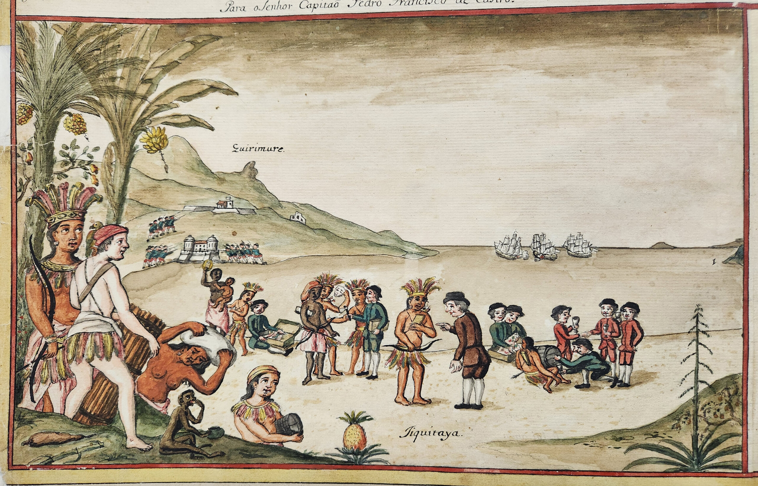
The image depicts an encounter at “Jiquitaia”, described by Sant’Anna as a beach in Salvador formerly known as a thriving commerce center for the area’s Tupi population, the primary Indigenous group of Brazil’s Atlantic coast. Though, in 1817, Jiquitaia was home to a newly-constructed Portuguese military fort —one that still utilized the beach’s Tupi name and so shows the Portuguese imperial appropriation of Indigenous landscapes—Sant’Anna envisions Jiquitaia as a place of ethnic egalitarianism and relative peace. Sant’Anna’s painting presents a group of white European men—identified by their skin tone and their dress—trading weapons, alcohol, and other objects on the beach. Tupi persons, depicted by Sant’Anna with feathered headdresses and skirts, interact on equal footing, as do persons of African descent. The two Black women he depicts appear to be in relationships with Indigenous men; one at left holds their child. In the foreground, a man with skin tone matching the white Europeans emerges with an Indigenous woman from behind a banana tree. His red cap and feathered skirt suggest he has long lived in the area’s Tupi communities.
As the figures on the beach point to trade goods with looks of curiosity and contemplation, and as they wear clothing contemporary to the sixteenth century, the watercolor evokes a sense of initial encounter, as if the Europeans are arriving at Jiquitaia for the first time. Sant’Anna’s title for the painting furthers this reading. “Kirimurê: Ancient Gentilic name of Bahia, and place where the City of Salvador was founded”, references the beginnings of Bahian history while also emphasizing the area’s Tupi name. However, further details complicate this initial timeline. Most obvious is the figure at bottom left, wearing a large feathered headdress, which has been identified as Catarina Paraguaçu, a sixteenth-century “Tupi indigenous woman from Bahia, who was offered by her father, the chief Taparica, to the Portuguese castaway Diogo Álvares, known as Caramuru”, an identification supported by the white figure accompanying her. In turn, Sant’Anna presents Black residents in Kirimurê and shows them as full members of Tupi worlds, even though no enslaved Africans arrived in Brazil prior to the mid-sixteenth century, after the “founding” of Salvador the title references. By including persons of African descent and Indigenous names in the scene at Jiquitaia, Sant’Anna does more than forward a vision of Brazil’s multiethnic history that would soon be enshrined in the 1824 Constitution. He also argues that Bahia’s “founding” is, perhaps, inextricable from the ways Black, European, and Indigenous worlds commingled and co-evolved in Brazil, independent of the histories of exploitative labor and land dispossession that characterized the late colonial and postcolonial imperial periods.
From a contemporary vantage point, this scene of egalitarian encounter appears like an apology or erasure of colonization’s violence. However, looking to the possible inspirations for Sant’Anna’s painting, critical distinctions emerge that show the force of his vision. The painting’s wide-angle landscape view, receding into a bay and framed with Brazilian flora, suggests Sant’Anna’s familiarity with longer histories of Dutch painting used to naturalize and aestheticize Brazilian landscapes and histories of forced labor.
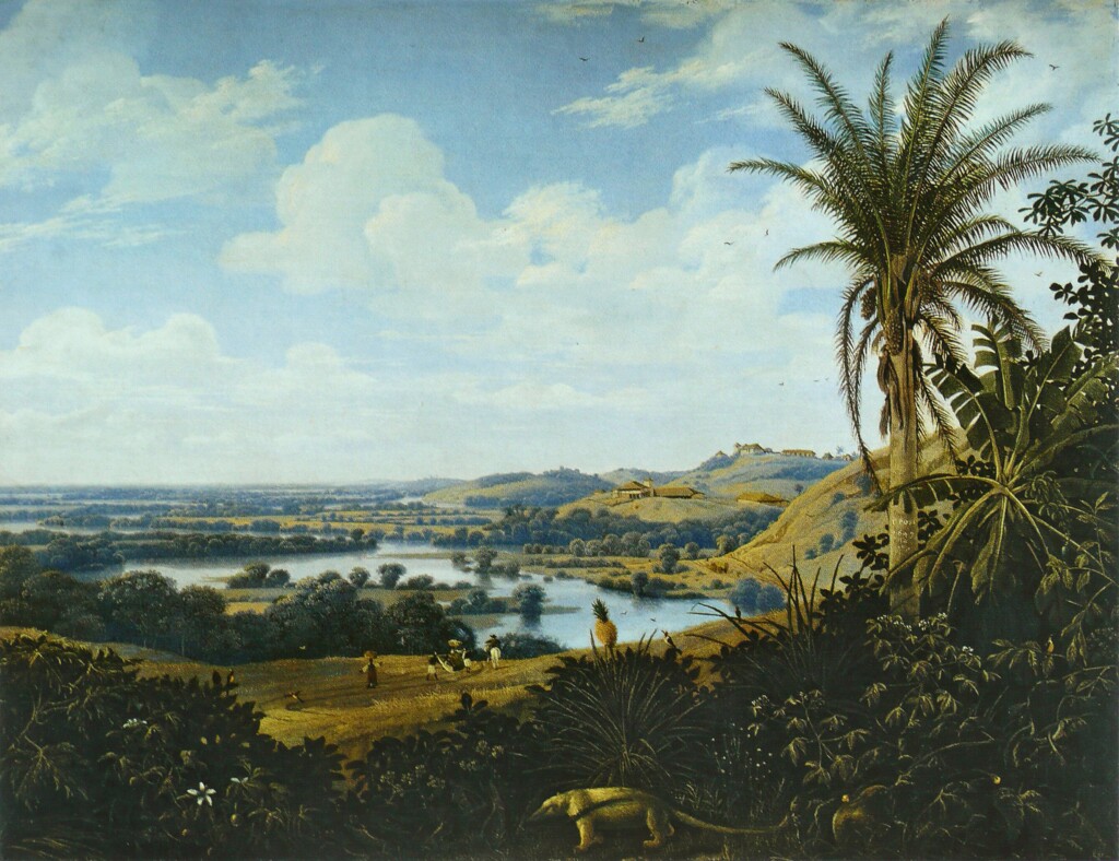
A 1649 painting by the Dutch artist Frans Post testifies to the role of Dutch landscape painting in aestheticizing enslaved labor in colonial Brazil. A wide view looks back to rolling hills punctuated with lakes and rivers. Industrialized sugar mills sit atop the hills at right, while enslaved people work a bit of cleared land at center. Post renders the centrality of industrialized slavery to Dutch Brazil as a natural, aesthetic inheritance of the Brazilian landscape. A small anteater traipses in the foreground, just in front of a prominent pineapple, while a tall palm tree at right – displaying ripe palm fruits dangling from the top—frames the image.
Sant’Anna’s artistic choices (see “Kirimurê” watercolor) suggest a throughline between colonially cultivated visions of tropical, edenic labor and Sant’Anna’s own painting. The foreground pineapple appears once again, as does the framing palm tree, alongside further floral additions like cashew fruits and a banana tree. However, unlike Post, Sant’Anna puts human action squarely in the foreground and emphasizes barter and economic exchange over attempts to aestheticize forced labor. Sant’Anna’s quite literal foregrounding of the word “Jiquitaia” may reinforce the point: the beach’s name is the Tupi word for the powdered form of a chili pepper native to the Americas. Highly desired by the Portuguese who purchased it from Tupi merchants, the chili was soon exported through Portuguese trade routes into Iberia and Africa. By the early seventeenth century, people across the Atlantic world instead called this chili malagueta after an unrelated but equally prized West African spice. Culturally and etymologically, Sant’Anna’s use of “Jiquitaia” harkens less to a pre-contact image of Tupi history than a wide-ranging reference to the co-evolution of Indigenous, African, and European knowledge in and through Atlantic commerce. Fittingly, Sant’Anna does not restrict Black and Indigenous figures to laborers or workers for an invisible white elite—in which the value of their lives would be restricted to their bodily production—nor, in turn, are they portrayed as being in awe of, or saved by, white settlers in the common trope of European saviorism that would run through Brazilian history paintings later in the nineteenth century. Instead, the beach scene places economic and cultural agency in the bodies and minds of Afro-Indigenous histories, while also disentangling sartorial practice and cultural identity from skin tone.
In this way, I read “Kirimurê” as Sant’Anna’s early effort to work through what the Black and Native Studies theorist Sandra Harvey outlines as a key problem in later twentieth- and twenty-first-century Black intellectual history and politics: how articulations of Black identities are often framed around what she frames as “an existential pull … that renders Black existence, especially but not solely outside of Africa, permanently and always already ‘unrooted’”. The counterpoint to that sense of displacement, Harvey notes, is often “the Western nation-state”.4Sandra Harvey, "Unsettling Diasporas: Blackness and the Spectre of Indigeneity," Postmodern Culture, 31: 1, 2 (2020, 2021).) Faced with a tension between Blackness’ uprooting and the patriotic cartography of Brazilian nationhood, Sant’Anna created a painting that refused to place Blackness in opposition to Indigeneity, a point underscored by the inclusion of the Afro-Indigenous child in the scene at Jiquitaia. As I detail below, he constructs a vision of Bahia’s founding that roots Blackness and even African botanicals as Indigenous. And through the presentation of Caramuru, the castaway, he refuses to let whiteness claim the political project of the nation-state, instead showing it as an equal inheritor of diaspora, Indigenization, and forced acculturation.
This vision of the co-constituted Indigeneity of Tupi and Black worlds Sant’Anna presents as constitutive of Brazil may be reinforced in the botanicals he depicts. Cashew fruits, at left (see “Kirimurê” watercolor painting), are native to Brazil, but bananas and pineapples—two fruits that Sant’Anna positions as native in this retelling of Bahia’s founding—were transported to Brazil from West Africa in the sixteenth century. While Frans Post’s mid-seventeenth-century painting participates in a longer colonial strategy of cultivating visions of botanical hybridity to aestheticize and naturalize the violence of settler colonialism, Sant’Anna reframes foreign transplants—which include human beings and cultivated plants—as altogether native to Bahia. This is what separates Frans Post from Sant’Anna: the latter asserts the antiquity of Indigenous and African shared knowledges and harkens to a diverse, vibrant world that includes them both, independent of histories of European domination. However, complicating this reading is another background detail showing how Sant’Anna continues to play with timelines: a battle scene likely referring to the 1625 joint Spanish–Portuguese reconquest of Salvador following its Dutch occupation. Perhaps Sant’Anna is collapsing the major events of Bahia’s history here, but it also speaks to the proto-nationalist tone of his Guia by re-envisioning the moment when Bahia was brought back under Portuguese imperial sovereignty, a point that may have carried strong weight as Brazil served as temporary home to the Portuguese Crown.
Why might Sant’Anna be asserting this vision of Afro-Indigenous antiquity and Brazilian national and imperial pride all at once? What motivated his project to imagine the political contours of Blackness outside of a diasporic framing?

Sant’Anna’s self-description on the cover page as a “painter” as well as an “old pardo” may reveal much about his intent. Pardo, a Portuguese word which has no translation into English, is the general term still preferred by multiracial Brazilians to describe themselves. In the early nineteenth century, pardo indicated a person’s African—and potentially also Indigenous—ancestry, but also more generally referred to someone who was neither white (branco) nor Black (preto), with the latter term typically suggesting enslaved status. As was true throughout colonial-era and early imperial Brazil, vocabularies and self-definitions of color were often “more to indicate social positions than referring specifically to an individual’s nature.” In this sense, pardo was often equivalent to mulato—another term referring to multiracial ancestry—but mulato carried stronger pejorative connotations. Sant’Anna’s upbringing in the second half of the eighteenth century took place around what the historian Miguel A. Valerio outlines as a “popular notion that mixed-race Afro-Brazilians constituted colonial Brazil’s most deviant and unruly socioracial group.” In this context, Valerio elaborates, those who could often expressed a “preference for the term pardo instead of the sullied one of mulato, [which was] popularly associated with licentiousness and ungovernability.”5Miguel A. Valerio, "The pardos’ triumph: The use of festival material culture for socioracial promotion in eighteenth-century Pernambuco," Journal of Festive Studies 3:49, 2021.
Sant’Anna’s self-definition may be related to his artistic prowess. Pardo artists in late colonial Brazil had greater access to artistic work and exploration and so could pursue opportunities unavailable to darker-skinned Brazilians in the late eighteenth and early nineteenth centuries. However, Sant’Anna may also have been invested in showing the role of pardos in the formation and participation of a nascent Brazilian national identity, as well as negotiating their political position in the midst of the movement of the Portuguese court and the African rebellions at the time he created the Guia. Sant’Anna’s sole reference to racial categories in the Guia is telling in this regard.
The Guia’s fifth map,depicting the captaincy of Mato Grosso in central Brazil, contains an intriguing detail along the bottom edge. Here, Sant’Anna relays the story of Tomás da Natividade, a pardo man, who was made a salaried infantry captain by the governor.
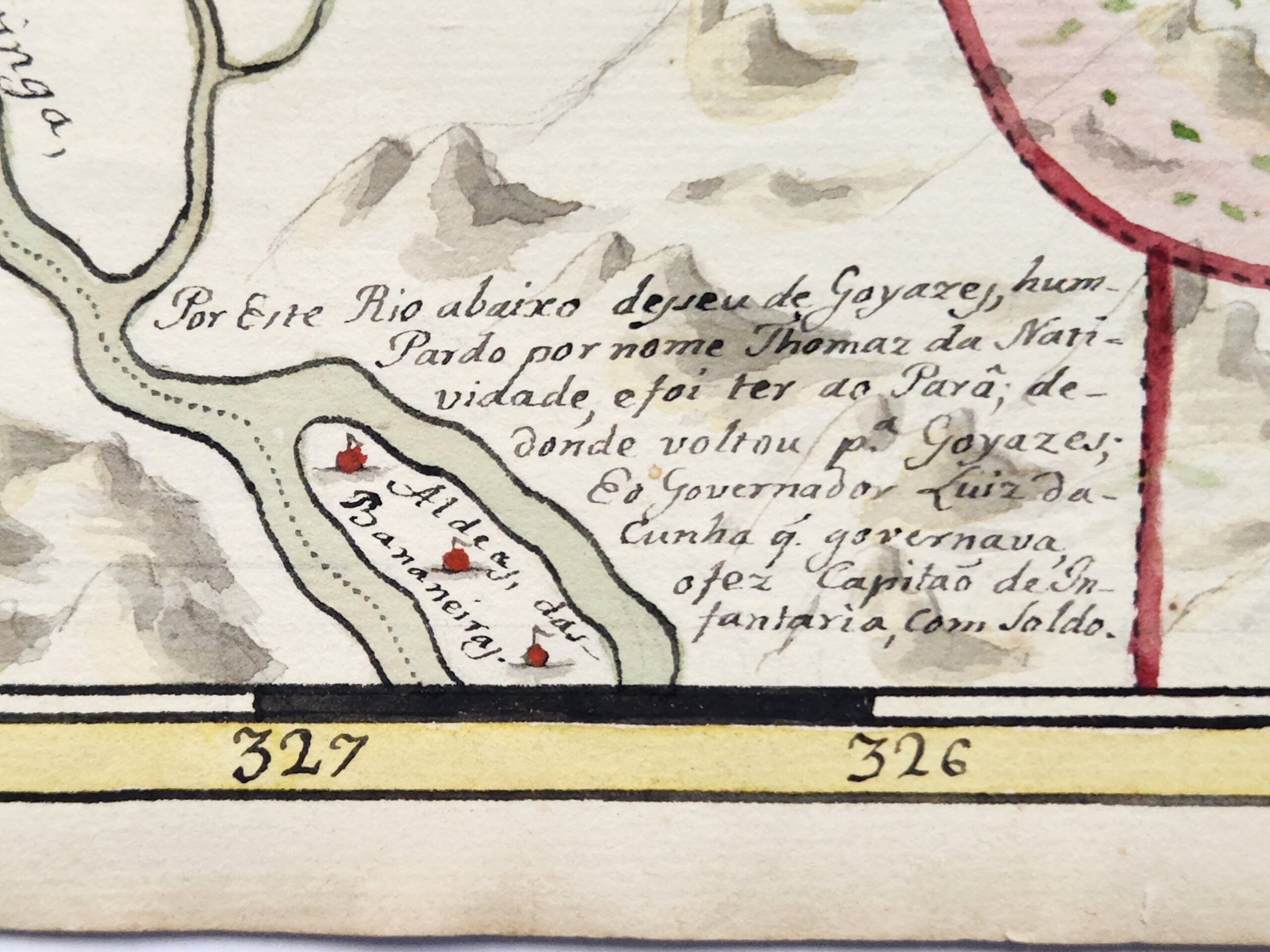
Why would Sant’Anna have gone out of his way to relay this little-known story? Did Sant’Anna delineate Natividade’s race as pardo—same as the artist—as a testament to his social position, either by status or by aspiration, to prove pardos’ participation in the construction and maintenance of the Brazilian state? Did Sant’Anna also testify to the position of pardos in a social context where they routinely faced barriers in compensation for their service in colonial conflicts? Intriguingly, Sant’Anna may have known pardos in Bahia as both artisans like him and militia members: at the time he completed the Guia, 60% of Salvador’s fourth militia regiment, which was reserved for mixed-race Brazilians like Sant’Anna, were employed as artists. Three were painters. But all likely held far less wealth than their white counterparts in the second regiment. While mixed-race Brazilians were common in Portuguese militia ranks, as were Indigenous Brazilians, their racial status posed frequent barriers to earning full salaries and land rights. And finally, might the reference to Natividade here remind the Guia’s readers of the political differences between Africans and Brazilian-born creoles like Sant’Anna, none of whom participated in the Bahia rebellions, and indeed, were likely among the militiamen who suppressed an African-led uprising near Salvador in 1816, just as Sant’Anna began work on the Guia?
Small details like this begin to put the viewer on notice of the multiple, overlapping political interventions in Sant’Anna’s work. This continues in the first manuscript map of the Guia: a planisphere of the Americas.
As art historian Tatiana Reinoza has outlined, the planisphere was deployed as a technology of what she calls the “Western cartographic gaze” and a proxy for territorial conquest and racial hierarchization reproduced on countless travelogues and cartography manuals dedicated to the colonization of the Americas, as we see in this 1703 frontispiece.6Tatiana Reinoza, Reclaiming the Americas: Latinx Art and the Politics of Territory (Austin: University of Texas Press, 2023): 18. Yet here, the map’s cartouche at bottom center—typically the domain of colonialist fantasies about Americas as an unpopulated territory prepared for the wide implantation of European settlements, or the deployment of figures that confine and define Indigenous and Black labor—instead emphasizes Indigenous empires. Sant’Anna’s text notes the “city of Mexico” and the “city of Cusco”, capitals of the Aztec and Inca states, respectively, their first and last rulers, and those rulers’ undoing by the Spanish in 1521 and 1533. Again, Sant’Anna not only highlights the antiquity of Indigenous civilizations here, but even asserts a new theory of the peopling of the Americas: Sant’Anna titles his map as actually identifying the “parts” from which those who populated the Americas came: “if from Asia, as various authors write, see the parts of China, Japan, and Tartary …and those who came from … Europe and Africa”. Sant’Anna collapses the entire history of the Americas’ peopling, putting all histories of forced and voluntary migration on equal footing while, importantly, decentering Europe spatially and discursively.
Sant’Anna’s map of Brazil, second in the Guia, further suggests his inspiration from much earlier works. Most maps of Brazil at this period were oriented with north at the top, while also outlining the Atlantic coastline and fleshing out the country’s interior: moves reflective of a kind of cartographic proto-nationalism that sought to form Brazil into an identifiable territorial boundary prior to independence in 1822. Such maps helped to render the nation as what the historian Sumathi Ramaswamy calls a “geo-body” necessary for would-be citizens to “see” the country politically and, in turn, to socially attach themselves to it.7Sumathi Ramaswamy, 2014. Maps, Mother/Goddesses, and Martyrdom in Modern India. In Empires of Vision: A Reader. Edited by Martin Jay and Sumathi Ramaswamy (Durham: Duke University Press, 2014): 420.This scheme was then reproduced on a global range of engraved and teaching maps after Brazilian independence, such as this example produced in Philadelphia in 1818 (below, left).
Sant’Anna’s Brazil breaks from this schema, orienting west at the top, a change that neither formed part of Sant’Anna’s corrective efforts nor would have been reproduced in any contemporary work. This style harkens to the sixteenth and seventeenth century, where European—especially Dutch—colonial cartographers commonly oriented Brazil with west at the top, such as in the 1644 example (above, right), which became the basis for nearly a century’s worth of maps in its wake. Also note here that this map contains a prominent inset, at top, depicting the bay of the city of Salvador, and so further speaks to Sant’Anna’s Bahia-centrism.
Sant’Anna’s Brazil also reduces the size of the Atlantic Ocean so that the west African coast peeks through the bottom right. This required shifting of the spatial dynamics from the planisphere the map before, suggesting the move is intentional. This style of showing the tip of Africa with Brazil emerged in the 1500s. Common through the middle of the eighteenth century, this style emphasized Brazil and Africa’s proximity to imply the facility of trafficking humans and goods between them.
In some cases, the link was explicit: the frontispiece to French trader Jean Barbot’s 1688 travelogue concerning his time in West Africa depicts the ocean as a connector between Brazil and West Africa, while two Black figures—aesthetic, celebratory archetypes of the slave trade—flank it. Yet this singular framing of Brazil and West Africa had effectively disappeared by the early nineteenth century. Is Sant’Anna here continuing to extol the slave trade as the backbone of Brazil’s economy—potentially a point that could further distance his racial subjectivity from associations with slave status? Might he also be subtly referencing Brazil’s strong African presence, something further suggested by the oversize importance given to Africa in the planisphere, where the continent almost dominates a map purportedly focused on the Americas? And if so, how does this detail operate in tension with the scene at Jiquitaia, which effectively refuses an image of Blackness tied to Atlantic slavery or diasporic African origins?
Sant’Anna’s eighth map, which depicts northeastern Brazil, may further testify to his work’s historical references and the multilayered histories of diaspora that inform it. Again, shifting typical orientation conventions by depicting northeastern Brazil with south at the top – he loves playing with perspective and directionality – Sant’Anna includes a critical detail: at the bottom of the map, he paints a small black building and labels it “Tapera de Angola; or Palmares.”
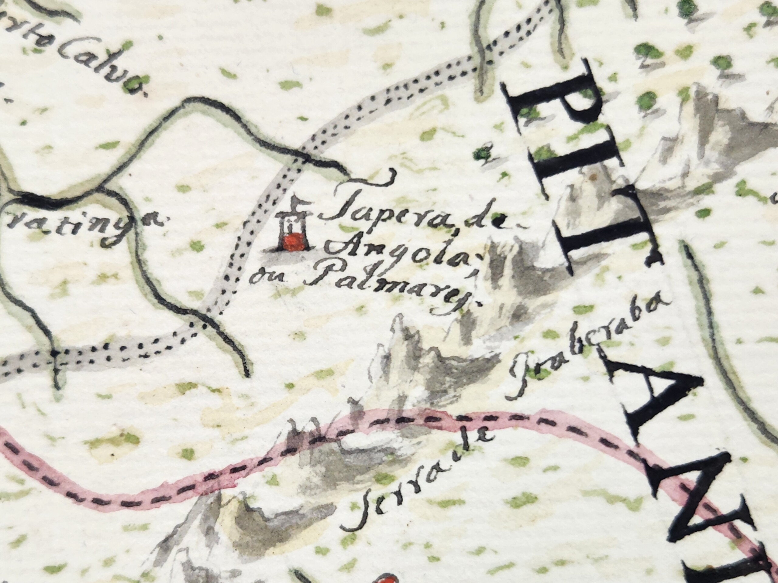
Palmares is the common name for a collection of maroon polities that existed in this region during most of the seventeenth century. At its height, Palmares had a population of many thousands, and was politically powerful enough that it conducted major conflicts and signed treaties with the Portuguese and the Dutch. Yet Palmares’ assumed destruction in 1695 means that it was an atypical location to be referenced on a map of the early nineteenth century. Indeed, only one other known map from Brazil’s entire colonial period—a map of this same region commissioned in 1766—names Palmares.
Moreover, the Guia’s pairing of “Tapera de Angola” and “Palmares” is unique in the history of cartography. The name “Tapera de Angola” only appears on one other known map: at the far bottom right of Dutch cartographer Joan Blaeu’s oft-reproduced 1662 map of northeastern Brazil, depicting the region’s occupation by the Dutch in the mid-seventeenth century. Sant’Anna’s use of this phrasing suggests he used Blaeu’s map specifically as a source of inspiration, nearly a century-and-a-half after its production (and in turn further supports the idea that Sant’Anna is taking broad inspiration from seventeenth-century Dutch Brazilian visual culture).
Naming Palmares in this way may have carried special resonance for Sant’Anna’s evocation of Brazil’s constitutive Afro-Indigeneity. On one level, “Tapera de Angola, or Palmares,” brings into intimate relation phonemes from three languages: “tapera”, an Indigenous Tupi word referring to a ruined or destroyed settlement; “Angola”, the central African polity strongly associated with Palmares, and the region commonly cited as its cultural and philosophical origin point; and “Palmares”, the Portuguese term for palm trees. Sant’Anna uniquely intermingles these sounds on the map, as if linguistically reproducing the kind of multiracial egalitarianism painted on the Guias’s frontispiece. Beyond the multivocality Sant’Anna’s naming provides, we cannot know how Sant’Anna understood the words’ meaning. Did he know, for example, that “tapera” referred to an abandoned settlement? What might this have meant for his evocation of “Angola” and the suggestion that this African polity, or at least its memory, existed or was even at home in Brazil—yet another iteration of the continent’s vibrant proximity to, and co-constitution of, the Brazilian state? If Sant’Anna did understand Palmares as abandoned or destroyed, what might he suggest by re-naming it here and connoting the potential for regeneration and new settlements in the area, maroon and colonial alike, long after Palmares’s destruction? And finally, how might we put this point in conversation with Sant’Anna’s insistence that previous cartographers had made “imprecise” maps of the interior of the state? Why did he make a specific choice to emphasize this historic terminology, and thus bring into sharp relief the coeval histories of Black, Indigenous, and white European diasporas? As elsewhere, Sant’Anna’s work provides few clear answers. Yet, perhaps it is precisely his emphasis on multilayered, multi-referential ambiguity, and the strategic intermingling of colonial, Black, and Indigenous epistemologies that provides the Guia its force.
I want to conclude with the words of geographer Chérie N. Rivers, who writes that “To explain [one’s] origins in relation to a modern political map is to accept a specific construction of space and time that imprisons [oneself] in the geography of global power.”8Chérie N. Rivers, To Be Nsala’s Daughter: Decomposing the Colonial Gaze (Durham: Duke University Press, 2022) 31. For Rivers, the line drawing and mapmaking of longstanding colonial relations presumes a geographic and spatial fixity that attempts to force racial subjectivity into a kind of essentialized boundedness and, in so doing concretize its utility for political and economic exploitation. Anastácio de Sant’Anna worked in the wake of cartographic projects of the colonial Americas which resonate deeply with Rivers’ argument about attempts made to codify and subdue racial identities in the service of proto-nationalist imaginaries, slavery economies, and military conquests. Yet, as “real” maps attempted to instantiate racial hierarchy, practices of Black fugitivity and independence threw them into ontological crisis. As outlined at the beginning of this essay, the work of theorists of Black Geographies show the consistent inadequacy of maps produced in the service of colonial projects, either by intentionally obscuring forms of resistance embedded in the very landscapes they represented, or by failing to incorporate—as a function of their medium—the manifold processes by which those in diaspora exist and move in and remember the world.
In its foregrounding of Black and Indigenous histories and placenames, in its evocations of Africa’s proximity to Brazil, and in its presentations of Blackness’ Indigeneity to Bahia, we might see in Sant’Anna’s Guia an effort to visualize those very forms of place- and space-making obscured by colonial military cartography; to, in other words, re-map and re-animate Black and Indigenous lives beyond the confines of the modern political map. The Guia explores and disentangles the historical timelines, diasporic histories, and racial imaginaries that pushed its maker to occupy a subjective position in the racial strata of the Portuguese Empire and the nascent Brazilian state. In this way, perhaps the Guia functions less as a political statement than as Sant’Anna’s attempt to work through the contours of a racial and political schema that asked him to choose between his mixed-race ancestry and his patriotism, or between his Blackness and his rootedness in and patriotism to Bahia. The Guia interrogates the extent to which cartography may not erase, but rather could foreground, a vision of Black history as part of the state’s geo-body. The Guia may not signify “an outright rejection of the colonial geographic and cartographic project as much as an underscoring of its inadequacy”, which might “distinguish patriotic art’s investment in the map form from the state’s command mapmaking ventures.” Through his genre-bending experimentations across painting and cartography, Sant’Anna attempted to rethink the genealogy of cartography in his homeland, all while asserting his—and other pardos’—sense of belonging and centrality to it.
About the Author
Matthew Francis Rarey is associate professor and chair of the Department of Art History at Oberlin College. He is author of Insignificant Things: Amulets and the Art of Survival in the Early Black Atlantic (Duke University Press, 2023). This Southern Spaces presentation is derived from an essay published by Professor Rarey in Arts in 2024, available here.
]]>Introduction—Salt Creek and City Nature

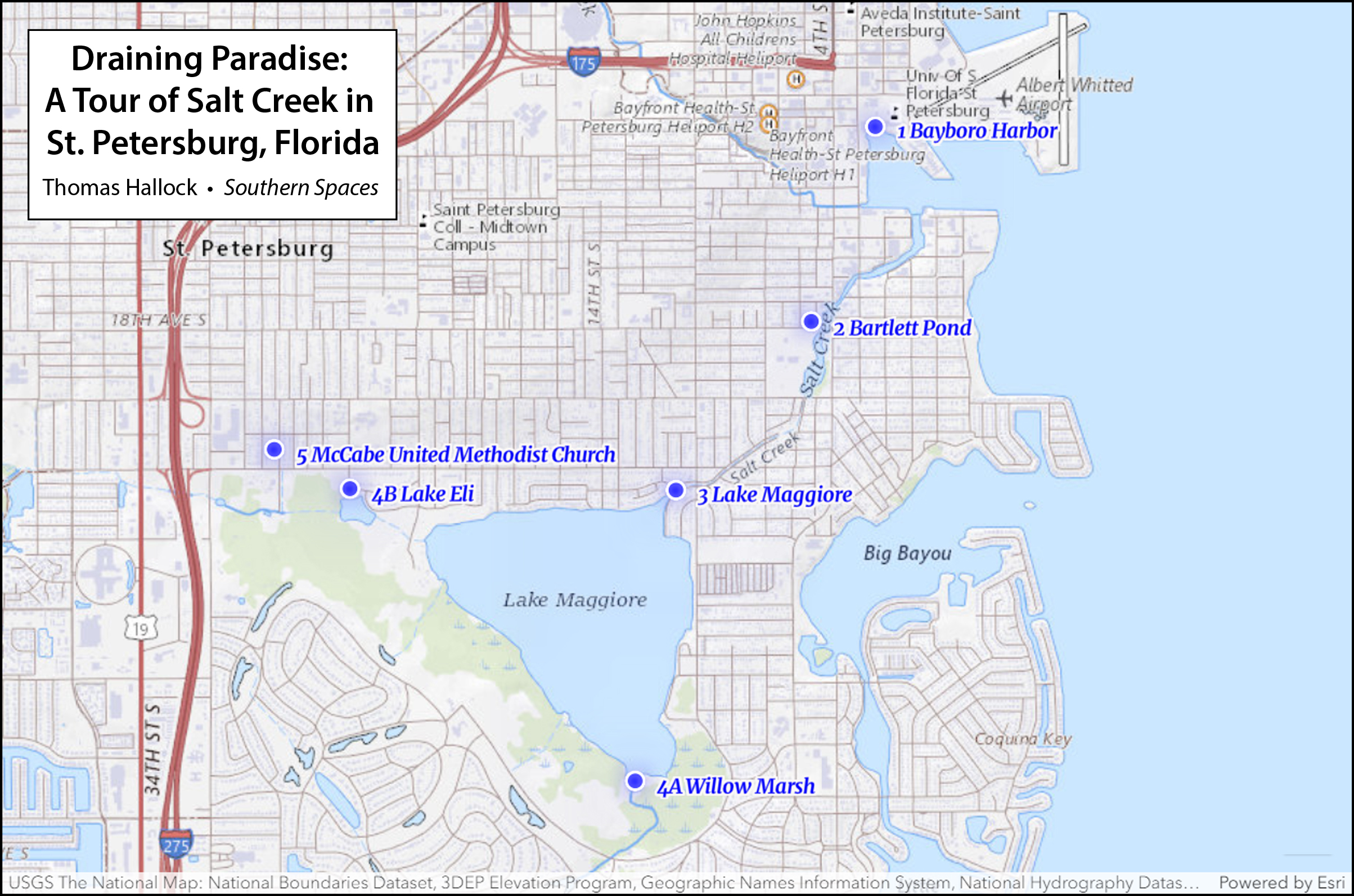
To place Salt Creek geographically, imagine the state of Florida. Zoom in to the west central coast,1This multi-media essay has developed over a long period of time and thanks are due to my home university's Center for Civic Engagement, the Frank E. Duckwall Foundation, the Tampa Bay Estuary Program, and most of all, to my students. Thanks to my comrades at Friends of Salt Creek; my church community at St. Augustine's Episcopal Church (at Salt Creek's headwaters), who have taught me to see my adopted hometown in a new light; to videographer Devin Rice; to Allen Tullos and anonymous readers for Southern Spaces; to Julie Armstrong, Jack Davis, Ray Arsenault, Amanda Hagood, Ray Roa, Chris Meindl, and Jacqueline Hubbard, Esq. then go to St. Petersburg, a midsized city—the second largest in the Tampa Bay area. St. Pete holds down the bottom of Pinellas County, a peninsula upon a peninsula, bracketed by Tampa Bay to the east and the Gulf of Mexico to the west. Water is everywhere.
St. Petersburg has always been two things: a resort town and a product of the segregated South. Known affectionately as the Sunshine City, St. Pete claims the Guinness World Record for sunshine (as a can of local craft beer will tell you, 768 consecutive days). This winter haven boomed in the early twentieth century. White vacationers and retirees flocked here for the weather, often to relax on the green benches (hence the beer) that once lined Central Avenue, the city's main thoroughfare and longtime racial divide. African Americans first migrated here to build the railroad and work the tourist economy, building tight communities over time.
Off the tourist map, Salt Creek remains absent from view, for reasons both geographic and social. Because the water flows in a northeast direction, starting from the middle of Pinellas County then into Tampa Bay, the creek falls off the orderly cadastral map. Avenues go East-West and the streets North-South, while Salt Creek cuts a diagonal course. Most of the creek's banks are culverted, so its "nature" does not adhere to conventional labels of leisurely consumption. Racial divides further hide this fragmented waterway, and the environmental merges with the Sunshine City's flickering, all-too-easily-denied Jim Crow past.
Today only a handful of locals can trace Salt Creek's full course. The best way is to start at the mouth, Bayboro Harbor, just south of the city's previously moribund but now skyrocketing downtown. As one journeys southwest, going upstream, the creek services a working port (properties now eyed for luxury housing). The creek passes under a mangrove cover and empty lots, owned mostly by absentee speculators. The city's sizeable population of street people, who use its shielded banks for shelter, are the principal stakeholders here. Under Fourth Street, a major north-south corridor, Salt Creek opens into mangrove-shrouded Bartlett Pond. Beyond the pond, it crosses under Twenty-Second Avenue South, also a major thoroughfare, before vanishing into a culvert through Harbordale, one of the poorest neighborhoods in Pinellas County. Dammed at the north-south running Dr. Martin Luther King, Jr. Street (or Ninth Street, to old timers), the channel opens into Lake Maggiore, historically an estuarine body of water, now maintained as fresh. Beyond the lake, finally, Salt Creek splits into several other unnamed sources.
Recovering an urban waterway is no easy task, as it requires travel across both time and space. This tour, "Draining Paradise," attempts to render visible our everyday—yet hidden—lives, where water meets land. Because Salt Creek pays no heed to squared-off boundaries or cornered streets, and because property claims trump natural processes, it suffers neglect. In a city founded upon leisure—moreover, with a disenfranchised working class needed to produce that leisure—what counts as "nature" inevitably falls along social, economic, and racial lines. A continuing legacy of inequity shapes environmental priorities. Yet Salt Creek's history is complicated. Water quality intersects with social structures, though not in any simple or straightforward way. The words and conventions we use to describe natural beauty fill in few gaps, nor do current models of environmental justice fully apply. This aquatic system passes through several different neighborhoods—white and Black, rich and poor, protected and industrialized, through parts of town in clear neglect and others in good health. The social constructs fragment the hydrology until a citizenry can no longer see itself in nature. So how do we teach ourselves to see the parts as one whole? Can we come together as a community by cognitively remapping a forgotten stream? If so, what terms do we use? What's the storyline for a creek that has become a ditch?
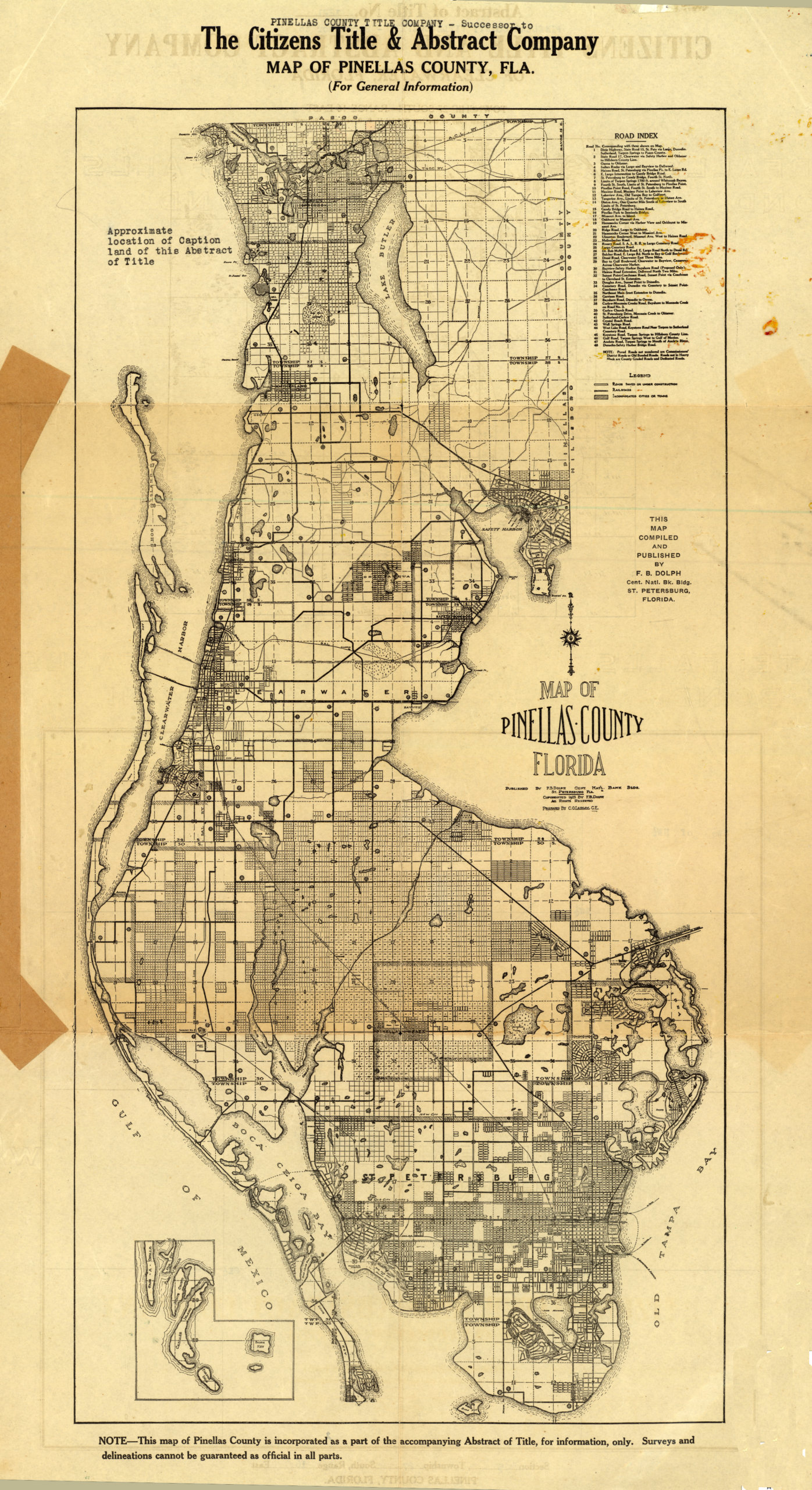
I first stumbled upon my problem quite by accident, as an extension of my job as an English professor at the University of South Florida's St. Petersburg campus. I came to USF as a part-time instructor, tasked with developing a course called "Rivers of Florida." For several semesters, I ventured with students in canoes and kayaks onto the state's many spectacular wild and scenic rivers—traveling hours for peak nature experiences amid awesome alligators, long legged wading birds, and floodplains filled with cypress—waving trails of Spanish moss over the slick obsidian water. Despite the beauty of our surroundings, student essays from the "Rivers" classes were mostly pedestrian paeans to the "real Florida" and laments for a vanishing nature. Tired of burning class time and fossil fuels, and bored with cliché writing, I turned to nature close to home—Salt Creek, whose mouth empties right onto our campus.
With little initial support, I threw myself into a curriculum that built nature around the city. The project came to consume my work as teacher, writer-researcher, citizen, and activist. The early stages were marked by confusion and indifference. The problem, from a pedagogical standpoint, starts with semantics. What happens when a stream or creek becomes a culvert or ditch? Why do those words matter? We urban dwellers, who seek out nature close to home, are linguistically bereft: there is no term to describe the successful interface of natural and built environs. Outside cities, we have any number of categories for describing natural landscapes. The "wilderness" and "preserve" define parks, without people; the "georgic" or "bucolic" covers farmland; a "pastoral" is where classical shepherds tended their flock while reflecting upon the corruption in Rome, and today denotes cherished spaces of imagined innocence—like a baseball diamond or the Andy Griffith Show. But nature in the city presents an absence. To address this problem, I set up a classroom model. I founded a fictional group, "Friends of Salt Creek," built a website, and started exploring with my students.2For a timeline see Friends of Salt Creek, Accessed April 11, 2023, https://friendsofsaltcreek.org/; for an example on how the critical terminology overlooks city nature, see survey in Greg Garrard, Ecocriticism (New York: Routledge, 2012), which is organized around a series of chapter-keywords (pollution, wilderness, apocalypse, dwelling, animal, earth), but no urban terms. Like a generation of environmental humanists, I first recognized the shortcomings of advocacy strategies and literary conventions after reading the edited collection by William Cronon, Uncommon Ground: Rethinking the Human Place in Nature (New York: W.W. Norton, 1996); more recently, I discuss cultural categories of nature writing, and the challenges of teaching city nature, see "City Creeks: Lessons in Sustainable Environmental Discourse from a Florida Boom Town," Spaces in-between: Cultural and Political Perspectives on Environmental Discourse, ed. Mark Luccarelli and Sigurd Bergmann (Leiden, Netherlands: Brill Rodopi, 2015), 88–101. Using searchable newspaper articles and government documents, we cobbled together a storyline.
The next step was to theorize. Environmental writer Jenny Price details "Thirteen Ways of Seeing Nature in LA," a classic re-examination of the least "natural" of all places, the Los Angeles River. On the East coast, meanwhile, landscape architect Ann Whiston Spirn has combined activism, teaching and writing in a recovery of Mill Creek, a buried stream that threads through West Philadelphia before feeding the Schuylkill. These models and others provided a conceptual groundwork. Over time, I accumulated equivalents. A trip to New York City took me to the Gowanus Canal, a Superfund site where Walt Whitman once ate oysters. I learned how tourists in London will lay out ten pounds each (five for kids) to slip down the culverted Fleet River, now a covered source but a notorious ditch from the reigns of Queens Elizabeth to Victoria. A sixteenth-century mock epic by Ben Jonson, "On the Famous Voyage," recounts a journey up the filthy Fleet: the open sewer runs foul with "grease, and hair of meazled [leprous] dogs; / The heads, houghs [hocks], entrailes, and hides of hogs."3Jenny Price, "Thirteen Ways of Seeing Nature in LA" (Part 1), Believer 33 (April 1, 2006); Anne Whiston Spirn, "Restoring Mill Creek: Landscape Literacy, Environmental Justice and City Planning and Design," Landscape Research 30, no. 3 (2005): 395–413; Ben Jonson, "On the Famous Voyage," in Complete Poetry, ed. William B. Hunter, Jr. (New York: NYU Press, 1963), 72. The same waterway carries away the cannibalistic offal of Stephen Sondheim's Sweeney Todd, "the demon barber of Fleet Street."
Patterns came together. Urban waterways offer a Realometer, as Thoreau wrote, places where you stand right to face the facts.4Henry David Thoreau describes the "Realometer," distinguished from the "Nilometer" (a gauge to measure the mythologized Nile), in the penultimate paragraph of the chapter "Where I Lived, and What I Lived For," from Walden, or A Life in the Woods (Boston, MA: Ticknor and Fields, 1854). Our city creeks mark charismatic, if uncomfortable points of context between activism and disaster fetish, economics and racial inequity, lost memory and recovery, cool-credibility, and very real marginalization. The more I traveled my own channelized waterway, the more analogs I discovered. Friends and colleagues started volunteering their own favorites. The Chicago River (a graduate school buddy reminds me) previously served as a portage between the Great Lakes and the Mississippi. A stunningly illustrated article in the New York Times charts the harrowing impact of sea level rise on this area.5Dan Egan, "A Climate Crisis Haunts Chicago's Future. A Battle Between a Great City and a Great Lake," New York Times, July 7, 2021, https://www.nytimes.com/interactive/2021/07/07/climate/chicago-river-lake-michigan.html. A colleague who graduated from Columbia's school of journalism reminded me that vestiges of Minetta Brook flow under Minetta Street in Greenwich Village. My writing partner for a series of #Creekshed essays in our local alt-weekly, Amanda Hagood, sent vacation photos of Ala Wai Canal in Honolulu. Another traveling colleague, a classicist, Facebook messaged me a photo of the vestigial Eridanos, Greece—the literal path to Hades—which runs through Athens' Monastiraki Metro stop. The community relations person on my campus insisted I walk the C&O canal on my next trip to to Washington, D.C. And while researching an academic memoir about her hometown of Birmingham, Alabama, my colleague and partner Julie Armstrong traced the entirety of Village Creek—a polluted stream that drains both industrial sites and a neighborhood park where she played as a child.6See Thomas Hallock and Amanda Haygood, "#Creekshed Story Map," May 5, 2022, https://storymaps.arcgis.com/stories/b664d097ee3e408c8eacf5a424075af8; for more information on the Ala Wai canal, a lagoon off Waikiki that displaced wetlands used by island Natives for fishing and agriculture in Waikiki, see Sophie Cocke, "Ala Wai Canal: Hawaii's Biggest Mistake?," Honolulu Civil Beat, May 20, 2013, https://www.civilbeat.org/2013/05/ala-wai-canal-hawaiis-biggest-mistake/; a display of Minetta Brook, which used to run through the lobby of a hotel-apartment, is no longer operable, though reference can be found at "Minetta Green," NYC Parks, Access April 11, 2023, www.nycgovparks.org/parks/minetta-green/history; Village Creek Environmental Human & Environmental Justice Society, Accessed April 11, 2023, https://villagecreeksociety.org; Julie Buckner Armstrong, "Two Days along Village Creek," Learning from Birmingham: A Journey into History and Home (Tuscaloosa: University of Alabama Press, 2023). East Lake was the white working-class neighborhood where Julie grew up. Through the post-civil right's era, it was mostly African American. Because of its increasingly coveted real estate, it became a focal point for the A&E program Flipping Down South.
Why this passion? And why is this work necessary? The recovery of an urban waterway can feel like a very vexed homecoming. Even though social history and economics have shaped our aquatic environs, current land use practices erase the very past that brings value, coherence, justice, and yes, even happiness to our communities. City creeks have a particular way of taking one both to the edges and into the heart of where we now live. We are habituated, as geographer Yi-Fu Tuan reminds us, to link memory and place. Tuan's term, "topophilia," is a well-known coinage for the memories that accrue across space. A crack in the sidewalk carries us back emotionally; a whiff of wisteria fosters connection, and one hopes, concern for a given locale.7Yi-Fu Tuan, Topophilia: A Study of Environmental Perception, Attitudes, and Values (New York: Columbia University Press, 1990). Though simple on the surface, the concept is tough to pin down; topophilia, Tuan reminds us, is not just patriotism, childlike nostalgia, or the marketing copy on a beer can. It means coming to grips with both the pleasures and the problematic.
Take the green bench, which is the name of my local brew of choice, but also a hurtful symbolism. As noted in a recent study of systematic racism in the city, green benches lined the main thoroughfare of Central Avenue from 1916 to 1960. For white residents, these benches were a "symbol of hospitality and place to socialize" on a pleasant winter afternoon; for African Americans, not being allowed to sit there served as an "everyday reminder" of humiliating segregation.8Tuan, Topophilia; Ruthmae Sears et al, "Building Bridges & Racial Equity in St. Petersburg Florida" (Tampa: University of South Florida, 2021), 52. City creeks, likewise, sit uneasily in our idea of nature. They do not offer simple recreation or respite. The active search for broken connections instead takes us beneath the placid surface of a city's daily life.
As a white northern transplant, I have learned how a recovered past opens channels for seeing a difficult present. Every metropolitan area holds its own hydrologic history, buried or forgotten. What I offer in this short trip is a lesson in how cities render nature invisible; how what we count as nature is either valued or subject to abuse, and how those decisions follow social lines; and how past, present, and future landscapes intersect. To cross into our fragmented waterways, I must add, requires humility. The divisions rendered in our shaping of the natural world remain. And so the fundamental challenge: to come together, as one community, cleaning our rivers and streams, while at least recognizing—if not starting to heal—the rifts between us.
Bayboro Harbor
Start at Bayboro Harbor, at the campus where I teach. Faculty, staff and students can rent a kayak, paddleboard, sailboat, or canoe at the waterfront office, and here, I typically begin my nature writing classes. Once called "Fiddler's Paradise," for the crabs foraging in the surrounding mangrove and spartina, this former bayou is where Tampa Bay meets Booker and Salt Creeks—two of the major drainage systems for lower Pinellas. The Gulf Coast of Florida has been home to a series of loosely-defined, overlapping cultures, more local polities than "tribes"; these include "archaic" groups, the Weeden Island culture (300CE–1000CE), followed by the Safety Harbor culture (900CE–1500CE), then Tocobaga (the residents of Tampa Bay who most likely met Spanish explorers in the sixteenth century). Florida's first people fished and gathered crustaceans. The refuse from this bounty formed middens and mounds, many of which appear on early postcards from the city. As St. Petersburg boomed through the twentieth century, during the early years of car culture, these shell mounds were looted for road fill. The Indian works, reminders of a successful synthesis of built and natural environs, remain buried under a hospital's out-parcels and parking garages.9Robert J. Austin, "'Its Origin Steeped in Mystery': The Sorry Saga of St. Petersburg's Shell Mound Park," The Florida Anthropologist 73, no. 2 (June 2020): 113–39; the ongoing status of Native remains, held at the Smithsonian and elsewhere, including (until recently) my university's anthropology department is reviewed in "Notice of Inventory Completion: Department of Anthropology, University of South Florida, Tampa, FL," National Archives Federal Register, Sep. 27, 2011; and Gene Demby and Kumari Devarajan, "Skeletons in the Closet," NPR Code Switch, Oct. 13, 2021, https://www.npr.org/transcripts/1045518876.
Salt Creek, meanwhile, tells the classic Florida story of transformation and rapine. The waterway formerly known as "Salt Run" drains lower-lying land, never particularly suited for human habitation. Starting in 1908, a group called the Bayboro Investment Company (supported by local boosters, fat with congressional pork) oversaw the harbor's dredging, which continued for several years. Imposing steam-fueled engines churned the roots, sand and gravel over bulwarks, carving a fifteen-foot channel from the shallow bayou, transforming the "marshy waste" into "valuable lands." Both Salt and Booker Creeks were straightened and deepened for the purposes of top-down economic interests: to connect with a rail depot one mile to the north, plus harborage for "pleasure yachts." Where there had been "naught but a marsh, inhabited by undesirable tenants" the St. Petersburg Evening Independent boasted, soon would "arise a beautified landscape occupied by happy homes of mankind." Four years later, with more federal funding, the city cleared frontage for a harbor and marina.10"The Bayboro Improvements," St. Petersburg (FL) Evening Independent, March 26, 1908, 1; "Deep Water Harbor Ordinance Up Tonight," St. Petersburg (FL) Daily Times, Aug. 14, 1912, 1.
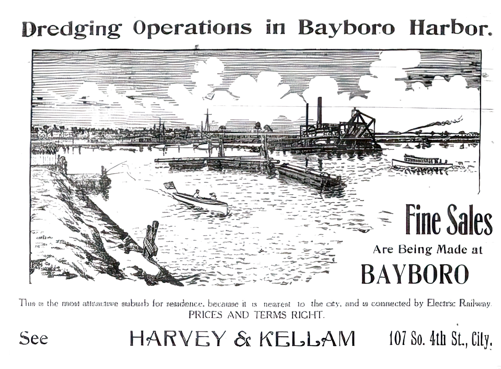
The creek's industrialization had begun. In 1913 the dredgers worked their way further up the channel, yoking the tidal "Salt Run" to Florida's violently enforced economic and social order. As standard histories recount, the area boomed through the first decades of the twentieth century, with a soggy landscape shaped to property developers who then marketed an affordable paradise for white tourists and transplants; this same paradise needed a labor force, and segregation shaped the landscape as much as the pleasures of outdoor leisure. An invisible line along Central had already divided the city into north (white) and south (African American) sides. African Americans moved to St. Petersburg in search of work and the city council sharpened boundaries where people of color could live. A 1931 charter amendment sought "to establish and set apart in said city separate residential limits or districts for White and negro residents." This redlining, impossible to enforce and revised many times, imprinted the city's demographics permanently, shaping everything from voter registration to school funding and supermarket locations.
Has the creek been subject to the same racial violence as Black bodies? It depends on who you ask, though this much is true: segregation in St. Petersburg remains unfinished business. Redlining language remained in the city charter until 1963; through the Jim Crow era, three lynchings were reported in Pinellas County (low for bloody Florida); and various groups such as Pinellas Remembers (which successfully placed an Equal Justice Initiative marker at the site of a 1914 lynching) continue the important, uphill work of healing. Environmental and social histories undoubtedly intertwine—the question is "how?"
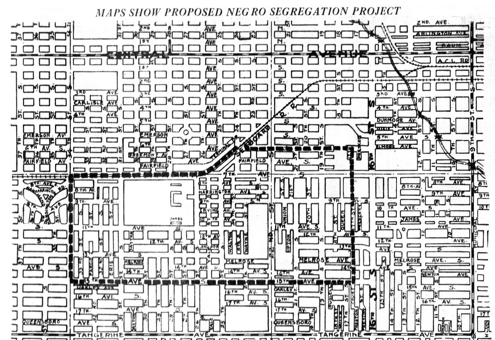
From its early boom years, access to nature came through a front and back door. North of Central Avenue, tourists enjoy Instagram-worthy waterfront parks, showcasing urban amenities alongside Tampa Bay. Today, these parks receive the overwhelming bulk of public funding and remain fiercely guarded by a proud citizenry. The adjacent working waterfront to the south was slated for industry, and set on a course for exploitation. Starting in the 1920s, city leaders commissioned engineering studies, supported business and secured federal money to construct an "industrial harbor." Salt Creek housed oil storage tanks (inevitable spills to follow) and just upstream, a dairy and flash-freeze seafood plants. As industry left in the 1970s, the creek would serve as a site for drugs and illegal sex and squatters, and now, for fast food and a Salvation Army support center. Locals recognize the creek (if at all) from a sharply-arched bridge over Third Street known as "Thrill Hill," or as the place where a sleeping homeless woman tumbled off a seawall and lost her arm to an alligator.
Such are the long string of anecdotes—the stories of drug runners and petty crime, childhood kicks, vagrancy and chicken thieves—that populate the creek's history.11City Council minutes were printed in St. Petersburg (FL) Times, Feb. 14, 1931, 2–3; see also "Open Waters in Salt Creek" St. Petersburg (FL) Times, June 16, 1921, 10. Most recently, the city revised building codes to accommodate Miami developers, who schemed to build high-density housing on the flood plain. That bubble having burst, the area remains scraped.12"Report of Port Exports Announced by Commission," St. Petersburg (FL) Evening Independent, Sept. 16, 1926, 7; "Dairy Concern Adds to Plant on Salt Creek," St. Petersburg (FL) Times, Jan. 1, 1937; "Yacht Basin Boats Face Clampdown," St. Petersburg (FL) Times, Feb. 3, 1960; "Salt Creek Squatters Trouble City Again," St. Petersburg (FL) Independent, Aug. 28, 1961; Jack Alexander, "Drug Raids Nab 11," St. Petersburg (FL) Independent, May 18, 1968.
Salt Creek activists suffer fatigue, even disillusionment, from fighting the combined forces of city hall, Jim Crow's intractable legacy, and poor decisions rationalized by free market economics. Two episodes from the past century illustrate the challenges of turning back the tide. The creek's path traces a low-lying area, or swale. In any other scenario, land this vulnerable to flooding would be set aside for parks and greenspace. Every good planner that has studied a topo map has, in fact, reached that conclusion. In the 1920s John Nolen, the preeminent city planner of his generation, prepared St. Petersburg Today, St. Petersburg Tomorrow—a design that would be considered progressive if it were adopted even now.13John Nolen, City Planning Report: St. Petersburg Today, St. Petersburg Tomorrow (St. Petersburg, FL: St. Petersburg City Planning Board, 1923), https://friendsofsaltcreek.org/wp-content/uploads/2022/02/St-Petersburg-Today-St-Petersburg-Tomorrow-1923-Nolen-Plan-1.pdf; St. Petersburg Conceptual Plan (City of St. Petersburg, FL, May 1974), https://friendsofsaltcreek.org/wp-content/uploads/2022/03/Conceptual-Plan-St.-Petersburg-1974.pdf: 31–32. Nolen suggested a parkway, using Salt Creek to connect gulf to bay with a chain of green "around the lower end of the peninsula." Voters rejected the Nolen plan, however, citing the imposition on private property rights as well as Nolen's reluctance to tighten emerging redline laws. One could blame this shortsightedness on the times. Nolen worked in the shadow of the Rosewood massacre, but fifty years later, the city reached the same conclusion.
Dusting off many of John Nolen's ideas, a 1974 Conceptual Plan also proposed a "green open space network," which included the "natural swale" between Tampa and Boca Ciega Bay. In short, a park along the Salt Creek channel.14R. Bruce Stephenson, Visions of Eden: Environmentalism, Urban Planning, and City Building in St. Petersburg, Florida, 1900–1915 (Columbus: Ohio State University Press, 1997), 65. Neither proposal, almost fifty years apart, made the leap to policy. A common good for the city (sustainable development, equitable access to open space) will lose to private, mostly white interests every time.
In the creek, I confront my own ambivalence towards Florida. I revel in the completely undeserved, over-the-top natural beauty. I also feel overmatched by the state's ugly, obdurate social history. When my own patience runs out, I drop a kayak near the mouth and make a favorite circuit. I enter by the harbor, paddle through the marina, then under the bridges at Third and Fourth Streets, into a hidden wilderness. Past the last dredge line, not far beyond the old trolley bridge, ice cream plant or seafood fast-freeze facility, the docks and crumbling piers give way to a mangrove tangle. Under Thrill Hill, Salt Creek is both wilder and more polluted. The paradox is striking, even in its own way, charismatic. The overlooked canopy serves as a bird sanctuary, where long legged waders roost and nest. Styrofoam and plastic bottles meld with mangrove prop roots. Fecal bacteria levels spike well past acceptable levels. We are still trying to figure out the cause—excrement from the street population, which the city pushed from parks in the tourist center to the poorer southside; guano, which accumulates in the concrete channel because seawalls and dam upstream block the tidal flow; or maybe broken sewer lines.
My route takes me roughly halfway to Lake Maggiore, mostly by industrialized lots left abandoned for speculation. Past the Dollar General and McDonalds, I push through the choking mangroves, then slip under another low-slung bridge at Eighteenth Avenue South. From here the creek opens into Bartlett Pond, a small aperture all but choked off due to overgrowth. I have seen snook roil below the black, murky surface. I've also seen a prize game fish, floating ominously on the surface of the muck. Osprey watch from their nests in the light posts by the athletic fields. Were it not for the hum of traffic, I could be in the 10,000 Islands of the Everglades. Instead I have found Nature in the heart of a city.
This is not where one expects to find a kayak. Citing water quality, Parks and Rec officials have ignored my suggestions to install a put-in off Bartlett Pond. So I engineer my own exit, grabbing the sewer line off a bridge on the opposite side, nudging a gunwale to the shoreline, and throwing my fifty-seven-year-old self onto the muddy bank. From Bartlett Park, I portage back across Fourth Street, past a gas station at the busy intersection of Fourth Street and Twenty-Second Avenue South, back to my once gay and racially-mixed, increasingly gentrified neighborhood. This circuit is not easy, scenic, accessible, or even encouraged. But I find the paddle into every day nature restorative. Wilderness has been erroneously thought of as an escape, rather than as engagement with the here and now. "In wildness is the preservation of the world," Thoreau mused, wandering the clearcuts around Concord. The best wilderness is always close to home.15Henry David Thoreau, "Walking," The Atlantic, June 1862, https://www.theatlantic.com/magazine/archive/1862/06/walking/304674/.
Bartlett Pond
At Bartlett Park, tucked behind Twenty-Second Avenue and Fourth Street, Salt Creek opens into a muddy pool. This little pond adjoins two of St. Petersburg's main thoroughfares, but badly eutrophied and surrounded by mangroves, rarely merits a second look. My wife Julie has lived three blocks away and driven past Bartlett Park for twenty years, but did not know there was actually water behind the brush. A little fishing dock used to provide access on the east side, away from the street and from the park's interior. Vandals, or maybe the homeless on a cold night, burned the outer decking. Repairs to the dock then came slowly and were poorly done. After I called to complain, the parks department blocked off the charred sections, shortening the entire structure.
Environmental racism takes many forms—big and small, from legislation to microaggressions. A perspective at water level renders visible the "slow violence" of local policy, to use Rob Nixon's memorable phrase: the damage "that occurs gradually and out of sight … dispersed across time and space [and] typically not viewed as violence at all." Leisure may not register as a health concern. At least on the surface. But in this city, defined by slow violence, differences in life expectancy across race are measured by decades.16Rob Nixon, Slow Violence and the Environmentalism of the Poor (Cambridge, MA: Harvard University Press, 2011), 2; Sears et al., "Building Bridges," 123. Hypertension kills, green spaces heal.
St. Petersburg and Pinellas County pride themselves on their parks, yet the allocation of amenities follows a classic script in inequity. A Pinellas County park map is literally a reverse image of racial demographics. Docks served by the county's white residents include ADA-compliant handrails, fish cleaning stations, and overhead shelters to protect visitors from the harsh sun or sudden rain. Residents in south St. Pete's poorer Black neighborhood instead get this charred shell, over an overgrown pond my spouse never even knew existed—where health officials deemed the water unsafe to fish or swim.
Economics and social history shape the landscape, but because the history is forgotten and on-the-ground-economics vanish into everyday life, that landscape is tough to read. Bartlett Park embodies this contradiction. Behind the stump of a dock, tennis balls thwock back and forth at the St. Petersburg Tennis Center. Founded in 1926, the municipal courts are a vestige from the early twentieth century, when the neighborhood afforded vacation cottages for winter residents and renting tourists. The court's location seems anomalous, though like every other chapter of the city's history, it can be explained through the local lodestars of leisure and race. The center serves as a throwback to St. Petersburg's peak years as a populist paradise, when white northerners suffering from cold found relief in the mild climate, bay breezes, the foliage, and sport.
The same boom drew African Americans, mostly from across the South, who came here to work a growing service economy. The zoning measures set out to keep the Black population both accessible and cordoned off; these measures, from the middle third of the past century, limited where Blacks could work, live, and travel after dark. African Americans forged communities in neighborhoods that still resound in local lore—the Deuces, Pepper Town, Gas Plant, Campbell Park, Methodist Town. After the waning of de facto segregation, in the early 1970s, once tight communities fanned out across the southern side of the city.17Rosalie Peck and Jon Wilson, St. Petersburg's African American Neighborhoods (Charleston: History Press, 2008), 15–18; Sears et al., "Building Bridges," 108. Black families settled in formerly white neighborhoods on the south side of town, including Bartlett Park. White people moved out, abandoning the neighborhoods, then decades later returned to the same sections—displacing Black families who have now lived there for at least a generation.
The contradictions and shifting dynamics across time and space make Salt Creek difficult to explain. Lime green tennis balls lob over the chain link fence, down the sidewalk, and into the watershed. Environment and community relations cannot seem to find the same page. I struggle personally with my own blindness, fumbling with good intentions. After several years of my teaching along this waterway, graduate students culled together a self-produced book called Salt Creek Journal. During an Earth Day celebration at Bartlett Park, I palmed a copy of the paperback to my city council representative. She actually read the book, then convinced me to form a real group with the same name as the pedagogical fiction—Friends of Salt Creek. For several years, pulled into service, I led the group. We defined goals, calling ourselves a community group centered around nature, not so much preservationist. We met small, consistent successes. Foundation money flowed our way, though before we were logistically prepared to take on projects; we had a grant before we had a bank account. For clean ups, environmental groups like Tampa Bay Watch and the Tampa Bay Estuary Program (who do admirable work advocating for marine health) bring enthusiastic white volunteers from outside, though our constant reminder has been to build from within the neighborhood. The local Keep America Beautiful office wants to drop in cypress trees without asking people who live there.
Conventional narratives of environmental justice, Ellen Griffin Spears observes, have "left out many constituencies—women, workers, indigenous populations, people of color, immigrants—and as a result left out the social justice roots of environmental reform." And so we see the broader trends unfold in local arenas. White environmentalists are not "looking at the community," observes Jacqueline Hubbard, an African American attorney whose family has owned a lakeside home in the area for decades; the result "is a lack of communication and trust."18Ellen Griffith Spears, Rethinking the American Environmental Movement Post–1945 (New York: Routledge, 2020), 4; In my informal interview with Jacqueline Hubbard (Sept. 2, 2022), she mentioned the importance of environmentalists reaching out to churches and groups with well-established records in civil rights; my hope as the author of this article, an online tour, is to have a ready-made program for community presentation.
In retrospect, the lesson feels obvious: restoring the environment starts with community. The questions must always start with, "for whom?" For whom are we working? With whom and why? Bartlett Pond brings fault lines into stark relief. After a long period of asking, the city secured external funds to dredge the eutrophied pond. The mostly white Friends of Salt Creek continue to test waters around the park, hoping to locate the sources of fecal bacteria. But why now? Will the dredging serve the neighborhood's current, mostly Black residents? What will dredging a pond mean for those experiencing homelessness? Is "improvement" merely a bellwether of high-end development downstream? And how does one fight back cynicism? During a May Day clean up, an African American fraternity, the Sigma Betas, led a tree-planting effort that involved local teenage boys. When construction in the park cut off an irrigation line, however, the newly planted trees dried up and died. This story is nothing new. Landscape theorist Anne Whiston Spirn recounts similar frustrations with Philadelphia's Mill Creek. She describes how she led eighth graders along the creek's buried course, then asked the teenagers to develop a landscape plan. The students (more familiar with the realities of the streets than an Ivy League professor) refused to believe any plan they implemented would be suggested. "It won't happen," a student told her; "Someone will wreck it."19Spirn, "Restoring Mill Creek," 404. How do you explain to teenage boys in St. Petersburg, likewise, that the city failed to water plants they put in the ground?
Advocacy puts well intentioned theory to the test. We have to pull out the Thoreauvian "realometer." In our rhetoric and scholarly discourse, one might wax optimistic about bringing together environmental and social justice, building what my local Sierra Club chapter calls a "Black-Green" alliance. But in practice, we learn the hard way, starting by acknowledging the depth of the rift of our divides. We can get the grants but we cannot exact meaningful change. As a white-led group, Friends of Salt Creek seems to have a offered a strategic wedge for easy volunteerism; our group checked the box for "underserved community." Over summer 2021, we drew from a Tampa Bay Estuary Program grant to support an artist in residence program at the local community center. Four artists (two white, two African American) met under a central pavilion, working most closely with kids. The children here are predominantly Black, with many coming from foster homes. White kids go to tennis camp, steps away, taking after-school lessons for $200 per week. Kids from the adjacent Frank Pierce Center are not accustomed to access. The pavilion where we met backs onto the chain-link fences of the neatly rolled courts. At one point, a child passed a gate left open, usually locked, leading to the public court. "Wait," the child asked, "can we go in there?"
The same could be said for the pond. Our entry points to nature are shaped by economics, power, and race. The points of access disclose social boundaries. Where equivalent parks offered sheltered docks and piers, the only dock here is a burnt out stub. The city clears and maintains lakes in other parts of the city, opening code-compliant "windows" through the mangrove; here, the water remains hidden—out of sight and degraded.
This is no accident. Past Bartlett Park, through a hidden gap in the mangroves, Salt Creek cuts diagonally, continuing to run southeast, through one of the poorer parts of the city. Neighborhoods along the creek tumble precipitously from coastal-slash-suburban to impoverished. Median household incomes drop in predictable blocks, as one moves from waterfront from properties along Tampa Bay and west into the city: $78,875 in the mostly white Old Southeast neighborhood, to $44,474 in the Bartlett Park area, to $12,096 in the more African American Harbordale section. A closer analysis provides a much more nuanced intersection of economics and race, not captured by simple caricature, though a trend exists. The city-data website reflects what anyone who lives in St. Petersburg already knows: economics fall along sharp racial lines, effecting in turn, health, access to fresh food, experiences with education and law enforcement, the possibilities of upward mobility, and of course, green space.20"St. Petersburg Florida: Income map, Earnings map, and Wages data," City-Data, Accessed March 31, 2023, https://www.city-data.com/income/income-St.-Petersburg-Florida.html. Structural racism study; see also Sears et al., "Building Bridges," 203-08.
Racial demographics and water quality intersect. At the end of legalized Jim Crow, as African Americans moved into the Harbordale neighborhood, the city let water quality sink. Low oxygen levels during the 1960s resulted in fish kills. Locals likened the smell at low tide to a badly operating sewage plant, the newspaper reported; outsiders (not residents) used the creek as an unlicensed trash pit. The rust colored water tested at almost eight times accepted levels for coliform bacteria. The city was no longer calling this waterway a stream or creek; in newspapers and press conferences the creek was now a "drainage area," or worse, a "ditch."21Willard Cox, "Tests Show [Red] 'Tide' Not Cause of Kills," The Evening Independent, July 6, 1965; "A Fishy Smell at Salt Creek," The Evening Independent, May 2, 1966; "Salt Creek Flow Sickly," The Evening Independent, Sept. 14, 1973; Bill Marden, "Trash, Tide A Problem," The Evening Independent, July 16, 1971. Racism did not cause environmental abuse; water quality was abysmal throughout Tampa Bay. A generation of activists, overwhelmingly white, have "saved the bay"—dramatically improving estuarine health. The poorer areas drained by Salt Creek, following script, are the last to see remediation.
Lake Maggiore
Semantics shape stewardship. At MLK (formerly Ninth, a major north-south street), a dam divides Salt Creek from Lake Maggiore. I am now in the middle-bottom part of the Pinellas Peninsula, on what used to be "Salt Lake," an estuarine habitat typical for coastal Florida. The name changed, however, alongside usage. In the 1920s real estate promoters began pitching new developments around a shallow, still tidal estuarine habitat. A fanciful origin story in the St. Petersburg Times provided the much-needed fiction. The newspaper, upholding real estate interests, staked a dubious claim that "Salt Lake" was discovered by Italian buccaneers, who called it "Maggiore" after a similar body of water on the Swiss-Italian border. In an act of rhetorical desalination, the hucksters presented the Italian as the earlier toponym; the sailors had first found fresh water, though mistakenly, the label "Salt Lake" stuck on later maps. Fiction and finances thus conspired to justify a dam. The Times cited a "peculiar condition" (or what the rest of us call tides) that allowed saltwater species to intrude from the bay. In 1930 a more permanent dam was built, making "Maggiore a freshwater lake for bass fishing." It would remain as such, until no one could recall when the brackish lake was part of an estuarine tidal run. By the 1980s the alligators were so pervasive that water skiers chased them off the slalom course. Neither bass nor gators belong in "Salt Lake," of course, as freshwater species have found their invasive niche in this badly translated Alpine lago.22"Lake Maggiore Believed to be Named by Pirate—To Be a Beautiful Section," St. Petersburg (FL) Times, April 5, 1925; "Lake Maggiore Dam Proposed," St. Petersburg (FL) Independent, Sept. 25, 1930. I am indebted to Jack E. Davis, who grew up on Lake Maggiore and who read a draft of this essay, for the observation about water skiing.
The folly, this not-just-semantic amnesia, has been expensive. Newspapers chronicle a twenty or thirty year cycle of restoration and waste. Eutrophication, fish kill, dredge Crisis, quick fix, repeat. In 1940, ten years after construction of the new dam, the city's Evening Independent would report:
City sanitation crews were burying hundreds of pounds of dead mullet and trout along the eastern shore of Lake Maggiore where they washed up after being killed by what [is] believed to be excessive vegetation gases in the shallow waters of the lake.
The newspaper described a horrific scene. Fish up to two feet long, panting in the grass; sanitation workers removing the rotting carcasses; the city vowing to install a screen to keep saltwater species out of the now-freshwater lake. Again, in 1963, the state game commission concludes that ecologically, the lake has become "old and not conducive to bass reproduction." Fish kills returned in 1968 and 1970, when the city detected chloride, a negatively charged ion that indicated "somehow salt water was getting into" Maggiore. In 1991, the headlines repeat: "Lake Maggiore Sick from Pollution," this time from high concentrations of run-off nitrogen and phosphorous. The following year, sanitation workers hauled off three-hundred pounds of dead menhaden (a coastal and estuarine species), snook, redfish, and yellow fin. Starting in 2004, the city spent two years scraping 1.3 million tons of sediment from the lake bottom. Trucks ran sixteen hours a day, five days a week, transferring the muck to a sod farm and developing area in the swampier part of the county's north end. After high levels of arsenic were detected in the soil, however, the city found itself in a sticky legal battle with the developer who used the fill, eventually settling with a million dollar contamination claim.23"Tons of Fish Die in Lake Maggiore," The Evening Independent Aug. 1, 1940; "Lake Maggiore: Fight Against Aging," St. Petersburg (FL) Times, June 25, 1971; Sue Landry, "Lake Maggiore Sick from Pollution," St. Petersburg (FL) Times, Jan. 16, 1991; "Natural, Normal Fish Kill Hits Lake," St. Petersburg (FL) Times, Nov. 2, 1992; Waveney Ann Moore, "Contaminated Soil to Cost St. Petersburg $1 million, 15 Years after Dredging Project," Tampa Bay (FL) Times, April 12, 2019; Southwest Florida Water Management District, "Final Phase of Lake Maggiore Restoration Project in Full Swing," Water Matters, May–June 2005, https://www.swfwmd.state.fl.us/blog/watermatters-magazine/11/final-phase-lake-maggiore-restoration-project-full-swing. Despite the added cost, toxicity, and history of repeating problems, officials declared victory. "This project attempts to set back the clock on a long history of water quality problems at Lake Maggiore," the Southwest Florida Water Management District (Swiftmud) triumphantly claimed. The irony is deafening. A plan has been set in place, with no heed for the existing pattern of waste. If the clock was "set back," as Swiftmud boasts, then only for the same problems to repeat.24Water Matters, "Final Phase."
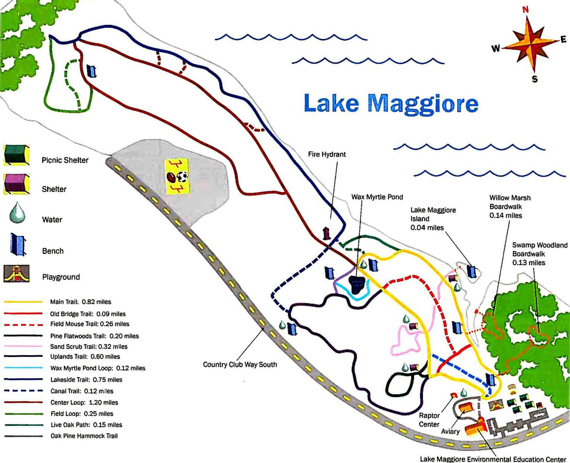
The lake remains awash in contradiction, mismanaged and lexically confused. The dam along MLK seeks to split salt and fresh water. Circle south, past some houses, by a fire station, and a mostly abandoned park. Spin further southwest and much of the land is sheltered by a beloved sanctuary, Boyd Hill Nature Preserve. Along the same tract, adjacent to the preserve, a city dump turns over mulch. At the base of Twenty-Second Street, historically the central corridor for St. Petersburg's African American population, sits a park. The north section fronts Maggiore Shores, originally a white neighborhood, then middle-to-upper-class Black, and today, increasingly white again. Each of the stakeholders holds a claim to the park—some smaller, some larger. Mostly white environmentalists aligned with Boyd Hill argue for removing the dam and restoring the ebb and flow of "Salt Lake." Older home owners in the Maggiore Shores neighborhood (to the north) want cattails around the edges cleared to improve their view; the current water management plan keeps salinity down and serves as flood protection. The only unifying factor is the cattails circling the lake, indicating low water quality. The common denominator is eutrophication; the argument is how to solve the problem. Renamed with a faux history, mispronounced, and managed against its natural flow, this once-tidal lake suffers from being something it is not.
Willow Marsh
On the south shore of the same Lake Maggiore, Salt Creek changes names (again). Then it disappears (again). The precise point of disappearance, ironically, occurs in a beloved nature park, Boyd Hill Nature Preserve, at one of the finest visual prospects in the entire city. A boardwalk on the Willow Marsh Trail faces North, towards downtown. Off in the distance, beyond the lake, cumulus clouds tower over one another, dramatically framing a vast blue horizon and restless skyline. Anhinga roost in a nearby island, and below, any number of species of ducks, moorhen and long-legged waders nudge through spatterdock and duckweed. Common sights are marsh rabbits and alligators, the mother gator often with her yellow-striped young brood. The visitor's map to the preserve marks this particular boardwalk as part of the Willow Marsh Trail, which presumably would make this area "Willow Marsh." Technically, the water forms part of a Salt Creek branch. Trail maps to the preserve, however, do not even mark a stream.
City nature has no place in a "nature preserve." At a point where an urban waterway should be most visible, even celebrated, the comedy of hide-and-seek intensifies. A waterway (now flowing due South) switches names. By the semantically confused lake, it disappears from the map altogether. Why? Because discursive "Nature" and the natural hydrology do not align. Near the Boyd Hill visitors center, hikers have unknowingly crossed Salt Creek. It is the little brook that trickles past an outdoor classroom, by the raptor rehabilitation center, and eventually reaches back to the edge of the nature preserve, where it runs under a chain link fence. Here, the creek becomes a culvert. And with subtle semantic shift, stewardship declines.
The aquatic thread snaps. We lose the connection. In a wealthy suburban neighborhood, the headwaters of Salt Creek runs through a maze of backyard overgrowth, accessible only with permission. To trace the creek now is to trespass. Care falls to individual whim or the conscience of private owners. One particularly zealous environmentalist has dutifully planted native cypress in the bottom, hoping to stabilize the sandy banks and restore habitat; elsewhere, the low-lying area remains mostly a jungle of invasive taro and wild ginger. Further south, where the planner John Nolen proposed a green corridor along the area's natural swale, the St. Petersburg Country Club has engineered the creek's headwaters into a series of water hazards for its golf course. Landscapers mow up to the edges of the artificial ponds along the golf course's back nine.
The hydrology has become impossible to visualize as one piece. Because the waterway is fragmented, no one connects the link from fourteenth fairway to Tampa Bay. Grass clippings run straight into the ditch, Lake Maggiore, into Salt Creek, and eventually into our beloved bay—feeding algae and toxic blooms that have undermined our quality of life, ruined countless fishing trips, and cost the state dearly in tourist revenue.25 The Tampa Bay Regional Planning Council set the loss of tourism revenue for a 2018 red tide bloom at $130.6 million; see The Ripple Effects of Florida Red Tide, (Pinellas Park, FL: Tampa Bay Regional Planning Council, 2019), https://tbrpc.org/wp-content/uploads/2019/01/The-Economic-Ripple-Effects-of-Florida-Red-Tide_unsigned.pdf; A more thorough study set the loss for the same bloom at double the cost, $317 million, see João-Pedro Ferreira, et al. "Impact of Red Tide in Peer-to-Peer Accommodations: A Multi-Regional Input-Output Model," Tourism Economics, March 1, 2022, https://journals.sagepub.com/doi/10.1177/13548166211068276. The neglected stream passes over a dingy concrete weir, amounting to little more than a one-stroke penalty for golfers and repository for lost Titleists.
Again, the aquatic thread splits. There are actually two larger branches feeding Lake Maggiore, the second no easier to trace. In its western course, the stream feeds a lake from a city tract along Dell Holmes Park. From here, it runs due West down a channel, where it parallels a public golf driving range. Canoes and kayaks rarely paddle this channel. The alligators are unusually large. One could go missing here altogether. If I am to put in at Lake Maggiore, I double check my life preserver.
The unnamed, culverted west branch cuts anonymously across public land. I can paddle upstream, with a city mulch processing plant to the left, and a drop-off site for brush to the right. The stream parallels the east-west running Twenty-Sixth Avenue South. Chain-link divides the landfill and private property, in this case two of the more prosperous historically Black churches in the city—St. Augustine's Episcopal and McCabe United Methodist. The location of these churches, or more accurately their relocation, figures into the last half century of city history. Both congregations served Jim Crow neighborhoods closer to the center of town, the middle class Campbell Park and poorer Gas Plant communities. Both neighborhoods were razed in the 1970s and 80s. Following a national trend, in which federal roads targeted Black areas, Interstate i-175 cut the Campbell Park neighborhood in half, running straight over homes where pillars of the African American community lived.
Ten years later, as if by design, the city razed the Gas Plant in the name of urban renewal, leveling a neighborhood to construct a domed stadium. The Tampa Bay Rays (Raze?) now play in the dome, Tropicana Field. But the team's owners (buttressed by city government and a newspaper that depends upon sports for daily copy) declare the thirty-year-old dome obsolete. Once again, the area awaits real estate redevelopment, with little probable return for the people displaced under the banner of "urban renewal" and promises to "get it right." St. Augustine's Episcopal relocated during the 1970s, moving from property now near the interstate, away from a community that has since scattered, and rebuilding on the rich soil of a former nursery near the head of Salt Creek's long swale.
Lake Eli
Where the creek ends remains an open question. According to an environmentalist friend who lives along the south shores of Lake Maggiore, the creek was historically sheet flow, tracing without record or immediate course through pine flatwoods. If I push a kayak further west, past Lake Eli, I trace the drainage ditch, almost to the churches that run along Twenty-Sixth Avenue. Just north of an arrow-straight culvert alongside the parking lot of McCabe United Methodist, the stream unceremoniously ends. The culvert takes a sharp turn at the boundary of church and city land, then runs north, along a straight ditch to north-south running Twenty-Sixth Street. On the other side of the street, Salt Creek finally disappears into underground maze of sewers. And from there, who knows?
Conclusion—Fragmented Headwaters
McCabe's presence at the headwaters embodies a painful chapter of St. Petersburg's history. The congregation of this century old church coalesced around segregated areas, along the eastern edge of the Gas Plant neighborhood. The congregants built the former church themselves, laying their spiritual home on the Black side of a segregation boundary. The interstate and dome destroyed the old structure, and today, the site is now a nondescript concrete parking garage. The current pastor, Reverend Jana Perkins-Hall, speaks clearly of the betrayal:
Black people got together, during that particular time of economic disenfranchisement, pooled their resources and physically built, brick by brick, this place of worship. They were there for fifty years before they were relocated . . . For what?
Perkins-Hall, though not a native, speaks powerfully on behalf of her parishioners: "So what kind of message does that send — spiritually, emotionally, psychologically — to the people who worked for free? That now, in place of a community they called home, is a parking garage?" There is no historical marker, even though stories continue to tell, "that this was once a place of sacred worship." The dislocation remains an unacknowledged erasure. A more visible reminder would at least acknowledge the hurt.26Jana Perkins-Hall spoke at a community forum about Booker Creek and the Tropicana Field site redevelopment, held at the University of South Florida's St. Petersburg campus on Feb. 15, 2019; see, Anna Maria Lineburger, Kelly Kennedy, and Dyllan Furness, ed., Voices of Booker Creek (St. Petersburg: University of South Florida, 2020), 29–30. Just as the teenage boy said to the Penn professor Anne Whiston Spirn: "someone will wreck it."
McCabe United Methodist Church
At McCabe, the unbaptized remnants of Salt Creek disappear into a sewer line, across from the church, at the corner of Twenty-Sixth Avenue and Twenty-Eighth Street. It is smack-dab in the middle Pinellas County, just east of the low sand ridge (a relic dune) that divides the peninsula. How and where the waters ran before development remains a question. Early histories and even the occasional map suggest that the outer reaches of Salt Creek mingled with a bayou to the west, possibly trading headwaters from both the swamp and bay' this memory of an earlier hydrology, however, remains repressed.27Walter Fuller, St. Petersburg and Its People (St. Petersburg: Great Outdoors Publishing Co., 1972), 5. The creek might have run straight across, serving as a liquid connector now lost.
Cities that bury their habitats sacrifice a bit of collective soul. Environmentalists in Los Angeles lament the failure to recognize the human, natural, and even cinematic history of the concretized Los Angeles River. Tourists are drawn to the Fleet River. New Yorkers still want to see the waters that bubbled under Minetta Street in lower Manhattan, and my archaeologist-art history friend clearly felt a connection when she stumbled onto the Eriadnos. With sea level rise, social scientists attend to the psychic costs of disappearing landscapes, citing what they call solastagia or "environmental grief."28Ellis Neville and Ashlee Cunsolo. "Hope and Mourning in the Anthropocene: Understanding Ecological Grief," The Conversation, April 4, 2018, https://theconversation.com/hope-and-mourning-in-the-anthropocene-understanding-ecological-grief-88630; Gren Albrecht et al., "Solastagia: The Distress Caused by Environmental Change," Australasian psychiatry: Bulletin of Royal Australian and New Zealand College of Psychiatrists 15 (2007); Ashlee Cunsolo and Neville R. Ellis, "Ecological Grief as a Mental Health Response to Climate Change-Related Loss," Nature Climate Change 8 no. 3 (2018): 275–281; L.P. Galway , T. Beery, K. Jones-Casey, K. Tasala "Mapping the Solastalgia Literature: A Scoping Review Study." Internal Journal of Environmental Research and Public Health 16:15 (July 2019). The social-historical context adds another layer. My partner Julie walked Birmingham's Village Creek in an effort to connect place and current-day race relations in this iconic civil rights setting. When I trace Salt Creek, I too seek this connection.
Hydrologic systems carry us into our history. They uncover buried pasts, helping us to explain unhealthy divides. Despite Florida's myths of paradise, we remain disconnected from the natural world, from the past that has built itself around us, from one another. Environmentalism needs community, and we best find community in a city's liquid heart. We need to know where the waters run.
About the Author
Thomas Hallock received his PhD from New York University. He is the author of From the Fallen Tree: Frontier Narratives, Environmental Politics and the Roots of a National Pastoral, 1749–1826 (Chapel Hill: University of North Carolina Press, 2003) and the co-editor of Early Modern Ecostudies: From the Florentine Codex to Shakespeare (New York: Palgrave Macmilian, 2008), William Bartram, the Search for Nature's Design: Selected Art, Letters and Unpublished Manuscripts (Athens: University of Georgia Press, 2010), and Travels on the St. Johns River: John and William Bartram (Gainesville: University of Florida Press, 2016). He recently published a series of travel and place-based essays that explain why he loves teaching the American literature survey, A Road Course in Early American Literature: Travel and Teaching from Atzlán to Amherst (Tuscaloosa: University of Alabama Press, 2022).
]]>For generations, African American families in Newton County, Georgia have told a haunting story about a tributary of the Yellow River known as "Dried Indian Creek," which meanders about ten miles through the municipalities of Oxford and Covington. The creek passes about a half mile east of the original campus of Emory College—founded in 1836, now known as Oxford College of Emory University—and directly past Bethlehem Baptist Church, the county's oldest African American house of worship. For two centuries the waterway has been a significant site of fishing, trapping, hunting, gathering, reflection, baptism, and recreation for the county's Black residents.
Local Black families are well aware of the white narrative about the name of the creek, published in multiple sources across the decades: when settlers came into the lands that would become Newton County (founded in 1821), they encountered the mummified remains of an individual, whom they assumed to be Native American, and named the waterway "Dried Indian Creek." This version was often told by the segregationist sheriff of Newton County, Henry ("Junior") Odum, (1915–1976), whose grandfather had established "Avon Indian Farm" near the creek. In Sheriff Odum's telling, the mummified Indian was discovered "stretched out under a big old tree."1Odum's account is quoted in a laudatory article about the sheriff in the Atlanta Journal Constitution, 26 May 1968, p. 172.
The African American narrative is different. Elders we have known recalled that when they were children in the 1930s, their elders told them that the creek's name bore witness to a terrible crime. When whites arrived, a courageous Native American leader refused to leave the land his people had long resided on.2We assume this Indigenous leader was Muscogee, but the older African American oral accounts we heard referenced him as "Indian" or "Native American." White settlers seized, beat him, strung him up, and left his body dangling over the water, not allowing anyone to cut him down until his corpse had dried. As the story was told, this early spectacle lynching was staged as a warning to Native and enslaved Black people that any challenge to white rule would be swiftly and violently put down.
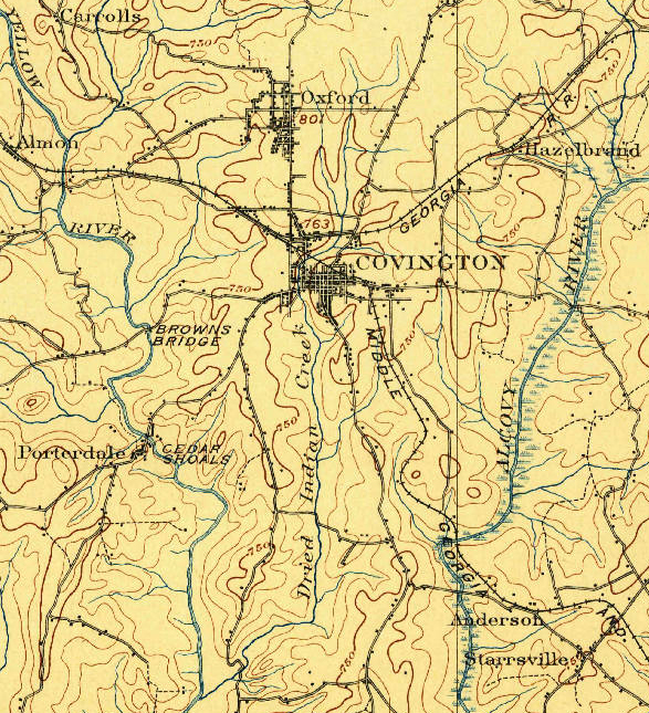
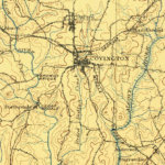
We know of only one white-authored account. The June 4, 1893, Atlanta Constitution reports that a Mr. W.D. Boggus of Covington has a number of curiosities on display in his place of business, including ". . . the leg bone of the Indian chief who was hung in 1795 and left to dry, near the old mill here in town, and from which incident Dried Indian Creek got its name."3Newspaper accounts from the following year state that Boggus wore a ring made from the "bone of an Indian warrior," exhumed from a plundered burial site near Covington (Macon Telegraph, 16 March 1894, p. 4). The individual in question, Woodson D. Boggus (c. 1868–1936), worked in the early twentieth century in Waco, Texas and in Payne, Oklahoma as an oil lease broker before returning to his home state of Georgia. (During the mid-1790s the area that is now Newton County was contested between Muscogee (Creek) inhabitants and encroaching white Georgians.) The Constitution article references the former site of Floyd's Mill, near where Bethlehem Baptist Church now stands, just north of the Clark Street bridge over the creek.
Overlapping Presences: Indigenous and Enslaved
No one we have spoken with recalls the name of this murdered Indigenous man, but the elders shared the belief he was distant kin to many African American families in Oxford. Most of these families trace their descent to two enslaved Native individuals, whom they believe to have been Muscogee (Creek). Cornelius Robinson (born c. 1836) was the enslaved valet of Alexander Means (1801–1883, Emory's professor of natural sciences, who during 1854–1855 was the College's president). Angeline Sims (born c. 1835) was enslaved with her husband George Washington Sims and their children, by Richard Sims, a founding member of Emory College's board of trustees and a founding commissioner of the town of Oxford. Angeline's daughters mainly remained in Oxford and married into local families; nearly every long-term African American family here traces descent back to one of these "Sims" women.
The elders knew that nearly all Muscogee (Creek) had been forced off the local lands around the time of the founding of Newton County, traveling to Alabama and points west, in some cases bringing with them their enslaved people of African descent. Yet they also insisted that not all "Indians" had left, that some intermarried Native and Black families had continued to live in the area.4Newton County, Georgia—created December 24, 1821, from Henry, Jasper, and Walton Counties—was based in three ceded Native territories. Under the terms of the 1805 Treaty of Washington, the 1818 Treaty at Creek Agency, and the 1821–25 Treaty of Indian Springs, all Muscogee lands in Georgia were ceded.
The late educator Emogene Williams (1931–2020), her mother "Miss B," and great-grandmother Sarah Baker Nelson recalled that there was an informal "Indian settlement" to the west of Covington, near Turner Lake, which persisted into the early twentieth century, when the Indigenous people were finally forced off the land. (As they remembered, there were also "gypsies" living in this settlement, who were also forced by whites to leave.) Local historian Johnny Johnson recalls that his grandmother Odessa Smith Gaither, born in 1885, shared stories about Native Americans who passed through Newton County when she was a girl, settling for a while and then "moving on."
A cluster of Afro-Native families continue to reside, semi-autonomously, along the Alcovy (Ulcofauhatchee) River, a couple of miles east of Oxford. (Large Creek villages are known to have been based along this watercourse in the eighteenth century.)5The 1805 Treaty of Washington between the United States and the Creek Nation references the "Ulcofauhatche" river; the term was used through the nineteenth century and was later anglicized to the "Alcovy" River. RaeLynn A. Butler, manager of the Historic and Cultural Preservation Department of the Muscogee Nation, notes that the Mvskoke spelling of the river would be: "orko ofv hvcce," meaning Pawpaw ("Orko," pronounced oth-go), river, or stream. Non-natives, she explains, must have heard "al-co" when mvskoke speakers were saying "oth-go" (RaeLynn A. Butler, personal note to author). See also Jonathan S. Tonge, Ulcofauhatchee: A Guide to Life Along the Alcovy River. Covington: Georgia Wildlife Federation, 2011. This small community of Angeline Sims's collateral descendants, her descendants recall, lived along the Alcovy upstream of the railway trestle, and defined themselves as "Indian" well into the twentieth century.
The late John Pliny ("J.P.") Godfrey, Jr. (1936–2020), great-grandson of Angeline, often visited this settlement of his kin when he was a child in the late 1930s and early 1940s. They trapped, fished, and minimized interactions with local whites. He remembered the elders would sing beautiful songs as they gazed out along the water, with words that were a mixture of English and "old Indian." The songs reminded him of "old Negro spirituals," but were somehow different. He sometimes understood them to be singing in remembrance of the ancestor, the old chief, who had been hanged by whites over the nearby stream and left to dry in the sun. Yet, he recalled, he never heard these elders express bitterness. "They just told me they were singing to help keep the waters rolling along." He smiled, "That's what they felt. Singing somehow helped the river, while the river gave them life and shelter."
Years later, J.P. and Mark walked along stretches of the river, but could find no trace of the old settlement he recalled from his childhood. "It's as if they were never here," J.P. sighed.
J.P and his cousins noted that most Black people in Oxford didn't talk much about their Indian relatives, but he did remember a story about his great aunt Minerva, Sallie's sister. "She was very strong willed. One time, she took her whole family down to live in Louisiana, in 'Ouachita' . . . She used to tell her children there was once a great city there, long before white folks ever came to America. They built pyramids there, just like the ancient pyramids." Records suggest that Minerva, her husband Tom Anderson, and their children lived in Ouachita from around 1890 to around 1908, when they returned to live in Oxford.
Years later, we read about archaeological excavations conducted in Ouachita, Louisiana, indicating that middle archaic mounds and earthworks at Watson Brake dated to at least 3400 BC. J.P. wondered just how Minerva could have known what she had known.
Founding Act of Murder
From time to time, the story of the murder at Dried Indian Creek has resurfaced in our conversations about the early history of Emory College and Oxford, where so many ancestors of local African Americans had been enslaved from 1836 until the end of the Civil War. Deacon Forrest Sawyer, Jr.—who had led the movement for desegregation in Newton County in 1970, famously defying Sheriff Junior Odum—said of Dried Indian Creek, "This county was founded with an act of murder. They were demonstrating the price that would be paid by anyone, red or black, who dared oppose white rule."
Emogene Williams, who traced her descent back to early enslaved persons and white slaveowners in Newton County (and who was the mother of this essay's co-author Rev. Avis Williams) concurred, "That is how they kept power in this county, through public demonstrations of violence, going all the way back to Dried Indian Creek. Lynchings, public executions of Black men scheduled as Black people were filing by going to church on Sunday."
J.P. Godfrey, Jr., whose grandfather Israel Godfrey had worked the land around Oxford in slavery and freedom, remarked, "I don't think it was entirely coincidental that Emory was founded right in the shadow of where that Indian chief was murdered . . . They wanted to show that they had taken hold of this land, and what would happen to anyone who opposed them."
These elders drew a direct link from the public desecration of the body of the murdered Indigenous man in the 1820s to the July 1946 mass lynching by about fifteen white Klansmen of two young African American couples at Moore's Ford on the banks of the Apalachee River in Walton County, which sent terrible shockwaves through surrounding Black communities in the early postwar period.
As Deacon Sawyer put it:
Rivers are the life blood, the arteries, of our land here. Rivers and streams were sacred for Indians, and it was those same creeks we'd steal away to, to feel the flow of the Holy Spirit—from the day we were brought to this county in chains. Of course, white folks chose to torture and kill our people along the river bank, reminding them that nothing was sacred. Any bond of family, any tie of love, could be broken in a moment. That's what white power was back then, and it still is.
Distant Kin: Black Oxford and the Creek Freedmen
These elders had long been fascinated by the stories of the Creek Freedmen, descendants of persons enslaved by Creek slaveowners, who had lived in Georgia and Alabama and then been removed to Indian Territory, later known as Oklahoma. Although there is no direct evidence of common ancestry between Oxford's present-day African American residents and the Creek Freedmen of Oklahoma, many local Oxford Black elders have felt a deep sense of moral kinship with the Freedmen. J.P. Godfrey, Jr., noted, "I know in my heart, those are our people. They were taken from these lands, suffered in ways we can't even imagine, but they endured. They're still our kin."

For J.P. and Emogene Williams, the 1979 de-citizenship of Creek Freedmen—descendants of those who had been enslaved by Creek slaveowners—was particularly painful. As J.P. remarked, "So many thousands gone from here. We had hoped our kin, though in bondage to the Creek, would have finally found a safe harbor in Oklahoma. Now we hear they were expelled, for supposedly being 'too African' . . . For our folks, you might say, the trail of tears never ended."6The precise motivations behind the 1979 changes in the Muscogee Constitution remain deeply contested. Defenders of the 1979 Constitution maintain the change in tribal citizenship was motivated by a desire to recognize only those Creek persons with sufficient Creek blood quanta as Creek citizens. Creek Freedman activists, in turn, insist the disenrollment of the Freedmen was motivated by racial animus, and illegitimately expelled many people whose ancestors had been considered Muscogee for multiple generations. Emogene observed, "I don't know how we're related, but I know from my mother and great-grandmother our people were all mixed together. It pains us to see those folks out West treated with such disrespect. Just like it was happening to us here."
Community members watch as leading figures in the Biden administration and the Congressional Black Caucus advocate for full citizenship rights being restored to all the Five Nation Freedmen. Secretary of the Interior Deb Haaland in May 2021 approved a revision in the Cherokee Nation constitution restoring citizenship status to Cherokee persons of African descent, and indicated her expectation that Muscogee (Creek), Choctaw, Chickasaw, and Seminole would recognize their "moral and legal obligations to the Freedmen."
By the Rivers of Babylon
In 2021, Emory University hosted a conference devoted to tracing the legacies of enslavement and the dispossession of Native American lands on the grounds that later became the institutions that comprise the consortium "Universities Studying Slavery," including Emory, University of Virginia, the Virginia Military Institute, Georgetown, Rutgers, UNC Chapel Hill, and Brigham Young University.7"Program Schedule." In the Wake of Slavery and Dispossession: Emory, Racism, and the Journey towards Restorative Justice. Emory Libraries. Accessed February 3, 2022. https://libraries.emory.edu/slavery-symposium/program-schedule.html. The conference opened with a painfully beautiful Muscogee hymn, "Espoketis Omes Kerreskos" ("This may be the last time, we do not know"), sung by Chebon Kernell, a mekko or ritual leader in the Muscogee (Creek) tradition, and a prayer by Rev. Avis Williams, an ordained Baptist preacher and daughter of the late Emogene Williams.8"Acknowledging the Ancestors with Readings, Music, and Prayer." Emory University. October 13, 2021. YouTube video. 1:13:29. The blessing and song by Cherbon Kernell and the blessing by Rev. Avis Williams are found at (00:00–11:30). https://www.youtube.com/watch?v=ELGjnpgdgJE&list=PLDSBylqXf9oGHja1c3mknOqz8JcVYMNfT&index=6. "Espoketis omes," which resonates with an African American spiritual, was sung along the Trail of Tears, as Muscogee families, including enslaved persons of African descent, made their way towards an uncertain future in the Indian Territory (Oklahoma).9The history of the song "Espoketis Omes Kerreskos" is explored in the 2014 film This May Be the Last Time (dir. Sterlin Harjo). More broadly, the film engages with the intertwined histories of Scottish Congregational line song, African American spirituals, and Muscogee (Creek) songs. Black spirituals and Muscogee hymns draw upon congregational line or note singing, part of a long musical and spiritual trajectory to maintain community amid wrenching dislocations.
Hearing Chebon sing, Avis was struck by the many parallels to the "sorrow songs" she grew up with in the Black Baptist tradition.10W.E.B. DuBois, "Of the Sorrow Songs," The Souls of Black Folk. Chicago: A.C. McClurg, 1903. Wikisource. https://en.wikisource.org/wiki/The_Souls_of_Black_Folk/XIV. In the first chapter of African Creeks (Norman: University of Oklahoma Press, 2007), Gary Zellar notes that early Christian missionization and evangelism in the Creek Nation in Georgia and Alabama was primarily associated with persons of African descent enslaved in Muscogee (Creek) communities. Had her ancestors and Chebon's ancestors perhaps sung together in the past, before or during the terrors of enslavement, forced removal, and land alienation? She was reminded in particular of Psalm 137: "By the rivers of Babylon we sat and wept/when we remembered Zion . . . our tormentors demanded songs of joy/they said, Sing us one of the songs of Zion!" Her ancestors, she knows, sang songs of sorrow but also of hope, in a strange land. So too, she thought, would Muscogee, including enslaved and free people of African descent, have sung these hymns, along many waterways, as they were expelled from their homelands.
On October 10, 2018, a Muscogee Methodist delegation gathered at the long-ago site of Standing Peachtree (Pakanahuili), the Muscogee (Creek) village that stood where Peachtree Creek enters the Chattahoochee River near present-day Buckhead, in north Atlanta.
They offered a prayer and hymn over the river. In a concluding commentary, Marilyn Cloud explained that in Muscogee tradition, "You add the prayer to the tobacco, because it is sacred. You put the tobacco in the flowing water. Whatever the prayer is that you make, the flowing river carries it."
Recently, we've held conversations about how these long-separated people might enter into dialogue. There are many unresolved legacies to work through, including the status of the Creek Freedmen, who are denied basic rights of tribal citizenship. Creek scholar and activist Craig Womack suggests music might be an appropriate starting point, to share and learn, and to hear voices of ancestors tied to riverscapes and landscapes that descendants consider sacred. Perhaps Muscogee and Newton County African American family members might gather along the river bank, joining in old hymns to honor the ancestor murdered long ago and left hanging over the waters, even as their voices, raised in song, help to move the river along.
About the Authors
Rev. Avis E. Williams, a community activist based in Newton County, Georgia, holds four degrees from Emory University (AA, BA, Master of Divinity, Doctor of Ministry). She works for the Putnam County Charter Public School System, and currently serves on the Oxford, Georgia, City Council.
Mark Auslander, a former faculty member at Oxford College of Emory University, is a visiting faculty member in anthropology at Boston University and University of Massachusetts-Amherst.
Acknowledgments
We are grateful for detailed comments on earlier versions of this essay from Craig Womack, Professor Emeritus of English at Emory, RaeLynn A. Butler, Manager of the Historic and Cultural Preservation Department, The Muscogee Nation, and Allen Tullos. We have benefited from guidance on Five Nations Freedmen perspectives on this complex history from Eli Grayson and Marilyn Vann. We acknowledge the teachings of many elders from the Newton County African American community, especially the late Emogene Williams, Sarah Mitchell Wise, Sarah Francis Hardeman, Mary Gaither McClurkin, Forest Sawyer, Jr., and John Pliny (J.P.) Godfrey, Jr.
]]>Video and Essay
Ossabaw Island is a barrier island on the Georgia coast. The island, which trends northeast–southwest, is about 14.5 kilometers (9 miles) long and 10.5 kilometers (6.6 miles) wide. It is located between latitudes 31° 49.5' and 31° 43.2' N. Of the Georgia barrier islands, Ossabaw is the most geologically unusual. Like the major Georgia islands south of it—Cumberland, Jekyll, St. Simons, Sapelo, and St. Catherines—Ossabaw is a composite island, in which sediments from Pleistocene and Holocene shorelines are directly adjacent or superimposed. However, sediments of the Pleistocene (Silver Bluff) and Holocene shorelines on Ossabaw split near its southern portion, with the Pleistocene trending north–south and the Holocene trending northeast–southwest. The modern shoreline, which formed only in the past few thousand years, wraps around the southern and northeastern corners of the island.
Ecosystems on Ossabaw include salt marshes, maritime forests, beaches, and a few freshwater ponds. Salt marshes are widespread west of Ossabaw, but also occupy much of the middle and eastern parts of the island between sediments of the Pleistocene and Holocene shorelines, dividing its maritime forests. The climate of Ossabaw is temperate to subtropical, with temperatures ranging from an average high of 32° C (90° F) in the summer to 10° C (50° F) in the winter. Average rainfall is about 50 centimeters (20 inches) per year, with most precipitation during the hurricane season (May–September). Hurricanes have rarely affected the Georgia barrier islands until recently, when Ossabaw was hit by Hurricane Matthew (2016), then later Hurricane Irma (2017). Hurricane Matthew, in particular, uprooted many of the older live oaks on the island and otherwise dramatically altered its landscape.
Although Ossabaw is often labeled as "pristine," humans have transformed its landscapes for at least 4,000 years. Its human history is similar to that of its island neighbor, St. Catherines, beginning with Native Americans (the Guale). The Guale had occupied Ossabaw since about 2000 BCE, but European colonization began when the Spanish arrived in the late sixteenth century. A lasting remnant of Spanish colonization on Ossabaw is the presence of feral hogs, some of which are linked to Spanish stock. This relatively large population of hogs has disrupted or otherwise altered ecosystems throughout the island.
The British took control of Ossabaw in the 1730s, by which time the Guale had mostly moved inland or suffered near extinction under the pressure of colonization. Early treaties reserved Ossabaw as hunting and fishing ground for the Creek people until 1758. The British also began enslaving African people for their plantation economy, and in the late eighteenth century American settlers continued using enslaved people as laborers for growing cotton and indigo. Most inland ecosystems of Ossabaw, especially the maritime forests and salt marshes, were altered considerably by this agriculture. Following the American Civil War, a significant population of African Americans stayed on the island, but most moved to the mainland after the Sea Island Hurricane of 1893. Many of their descendants today comprise the Gullah-Geechee community in Pin Point, Georgia.
Through the early to late twentieth century, Ossabaw's ownership changed several times, but the island remained largely undeveloped and sparsely inhabited. The last private owners were members of the Torrey family, starting with Dr. Henry Norton Torrey and Nell Ford Torrey, and ending with their daughter, Eleanor Torrey ("Sandy") West. The Torreys oversaw the building of a large home for themselves, as well as hunting lodges, a beach house, and unpaved roads. In 1961, after Sandy West inherited the island, she and her husband Clifford West began the Ossabaw Island Project. This project brought luminaries of the arts and sciences to the island as a retreat center for study and discussion; notable participants included composer Aaron Copeland, writers Ralph Ellison, Margaret Atwood, and Annie Dillard, as well as ecologist Eugene Odum. This creative initiative also resulted in the Genesis Project, which focused more on the natural sciences and hosted scientists for on-site studies of and education about the archaeology, ecology, and geology of the island.
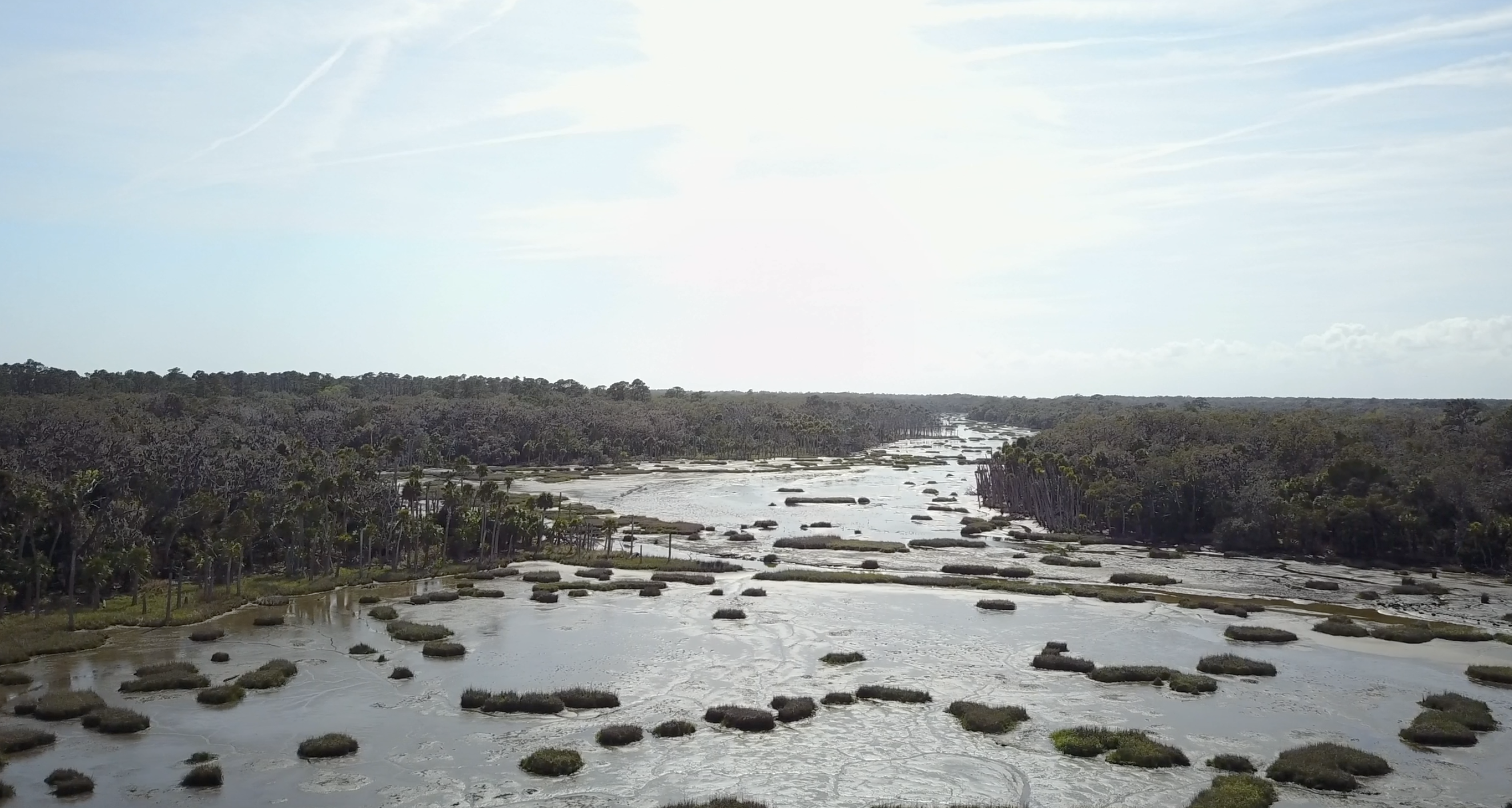
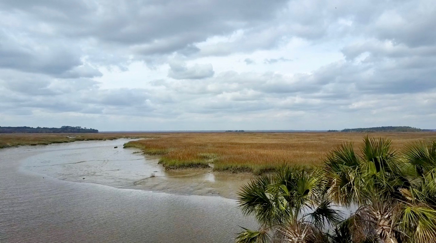
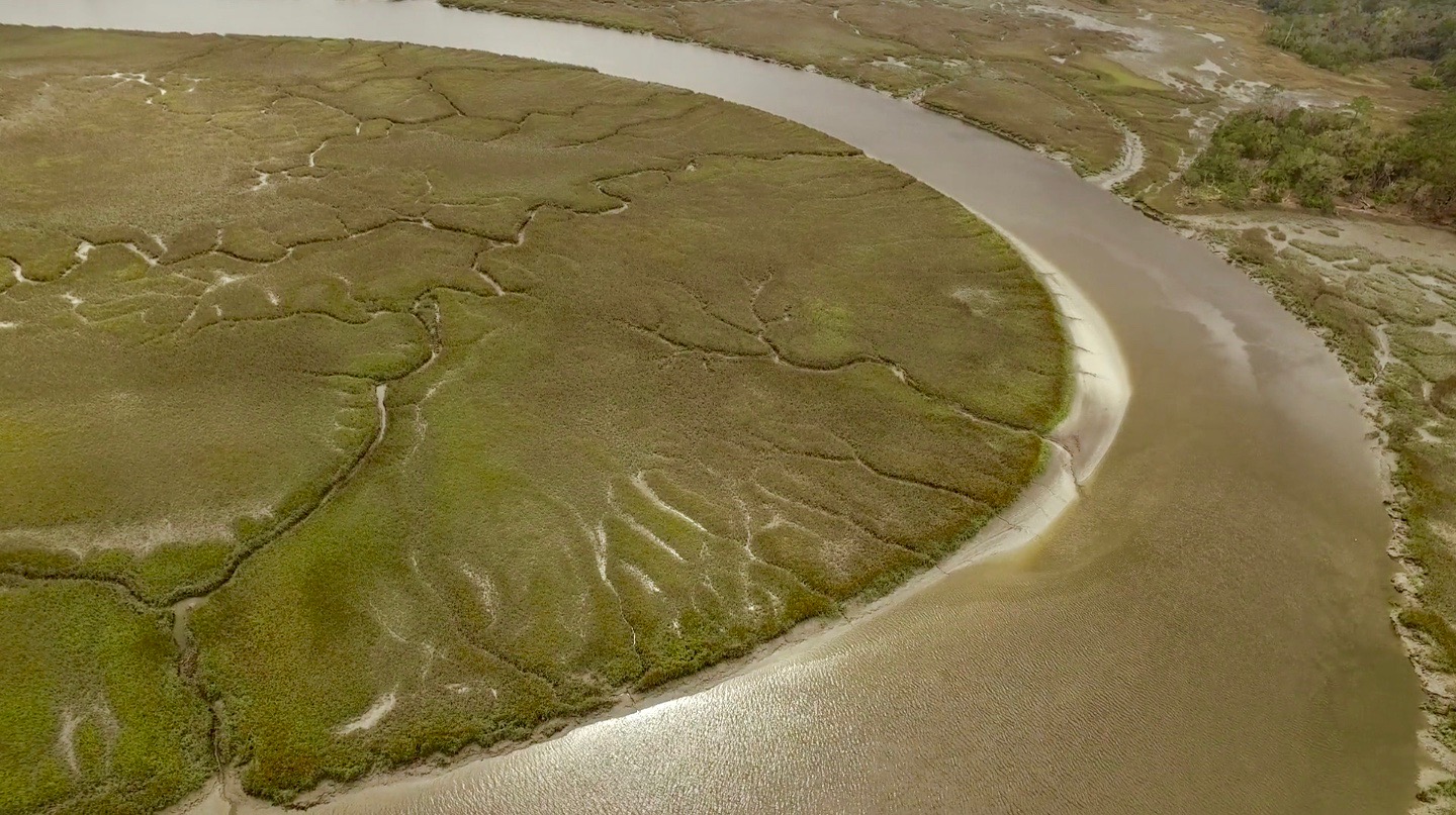
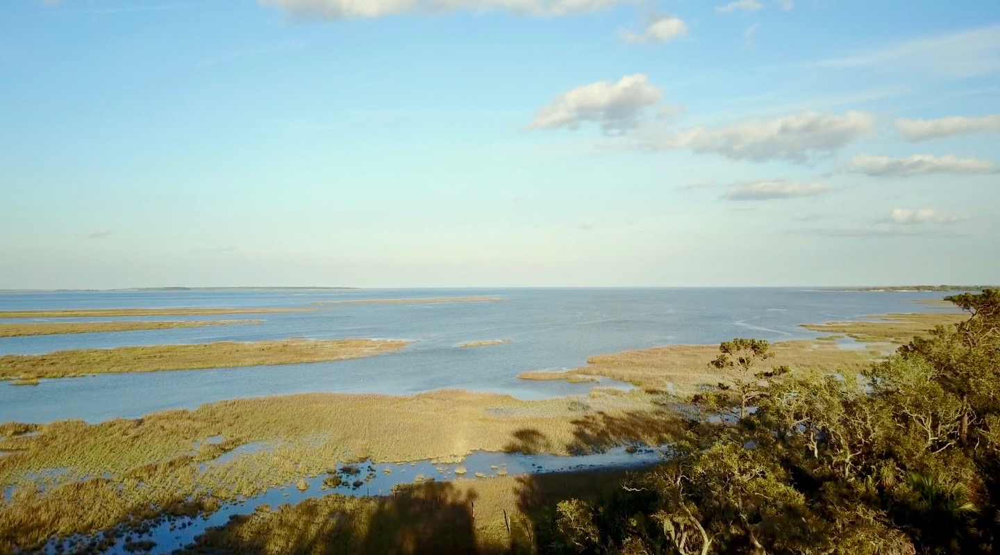
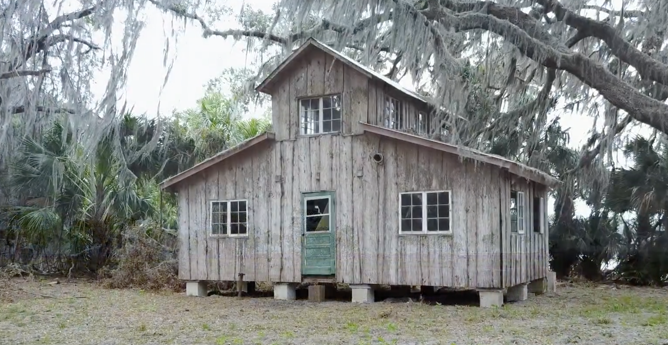
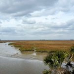
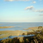

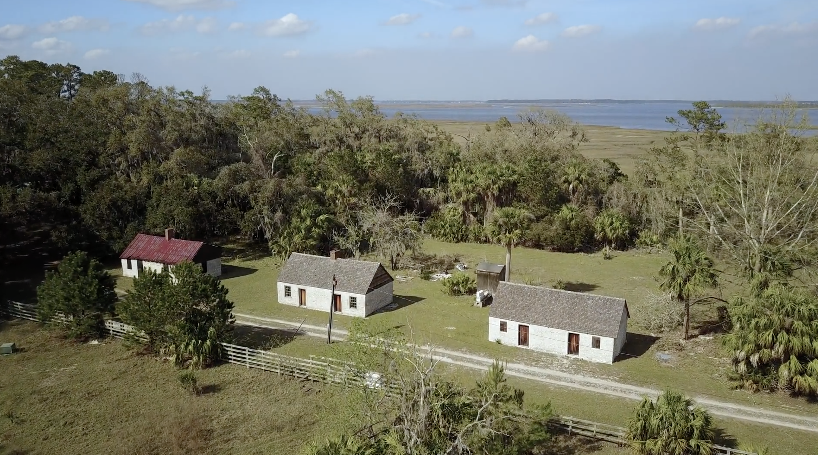
In 1978, Sandy West sold Ossabaw to the state of Georgia to establish it as the state's first heritage preserve, and it has been managed since by the Georgia Department of Natural Resources (DNR). The Ossabaw Island Foundation was established afterwards as a non-profit organization working with DNR to encourage educational, cultural, and scientific programs on the island. Sandy West continued living on the island until just recently; at the time of this writing (January 2020), she was living in nearby Savannah, Georgia, and had just celebrated her 107th birthday.
This Ossabaw flyover video provides a visual sample of the many interconnections between natural and human histories on Ossabaw. Featuring sweeping aerial views and audio annotations explaining the island's varied environmental features, this video is organized around four sequential but overlapping themes: fauna, flora, landscapes, and human structures.
Acknowledgment
Thanks to the Ossabaw Island Foundation for their support on this piece.
About the Authors
Anthony "Tony" Martin is a professor of practice in the Department of Environmental Sciences at Emory University. His publications include Life Traces of the Georgia Coast (Bloomington: Indiana University Press, 2013).
Steve Bransford is the senior video producer at the Emory Center for Digital Scholarship. His documentary feature film The Well-Placed Weed is available on the PBS website and app.
Michael Page is lecturer in Geospatial Sciences and Technology at Emory University.
Leotie Hakkila is an MPH student at the Rollins School of Public Health, Emory University.
Anandi S. Knuppel is a visiting assistant professor in the Department of Religious Studies at Lawrence University.
]]>Women's Space, Queer Space: Communes, Landykes, and Queer Contact Zones in the Lesbian Feminist South
The middle-aged man sitting in the row in front of me shoved his wife's arm and pointed at two women. "See?!" he said, conspiratorially, derisively. I looked at my friend Cheryl and raised an eyebrow. Where did he think he was, anyway? The Southeastern Conference (SEC) Women's Basketball Tournament audience is filled with lesbians—butches, femmes, sports dykes, some distinguished by a modified mullet, others by their no-makeup, tennis shoes, and jeans uniform, but all united in their obsession with women's basketball.

Of course, the tournament audience includes others besides lesbians; like most queer spaces in the South, lesbians share the space with many other groups—retirees, parents and their tween daughters, and random diehard SEC fans who love their team or really hate their rivals. Yet the SEC Women's Basketball Tournament is a roving capital of the southern sisterhood, and it is anything but subtle, but if you ask the fathers and the busloads of white-haired retirees about all the lesbians they will look at you blankly, whether they noticed them or not.
This is because "the South" has always been an imagined community, based in wish fulfillment and aspiration, that depends upon deliberate unlooking. It excludes populations that, collectively, comprise a majority of the population. It excludes black southerners, who understandably have a more ambivalent relationship to the "sense of place" invested in their subordination. It excludes the many immigrant groups that have made the South their home over the generations—Chinese, Lebanese, Italians, and more recently, Indians, Vietnamese, Africans, Hispanics. It ignores queer southern communities in towns both small and large. In other words, the "sense of place" so beloved by traditional southern literary critics overlooks the actual people in that place.
This tendency to disavow the full complexity of diverse communities in the South has a long, shameful history. The Confederacy imagined a southern aristocracy based on honor and culture, obscuring a white supremacy dependent on stolen slave labor. Post-Reconstruction politics did more than rewrite the cause of the Civil War—it also remade the space of the South: Confederate memorial statues were erected, often in town squares or in prominent public locations, as Jim Crow laws limited the spaces and places African Americans could live, work, and recreate.1For more see, Caroline E. Janney, Burying the Dead but Not the Past: Ladies' Memorial Associations and the Lost Cause (Chapel Hill: University of North Carolina Press, 2008) and Micki McElya, Clinging to Mammy: The Faithful Slave in Twentieth-Century America (Cambridge, MA: Harvard University Press, 2007). The fact that these public Confederate monuments still dominate southern spaces, and that their removals provoke intense debate and outcry, suggests how effectively this southern space made inequity seem natural.
The ubiquitous notion of a static, conservative South has led to many unwarranted assumptions about LGBTQ communities and their incompatibility in the South. Gay liberation was framed as an urban phenomenon; gay people leave their inhospitable small towns and regions and build a critical mass in major cities like New York and San Francisco, where their visibility and numbers result in political clout and political influence. Greenwich Village in New York and the Castro in San Francisco were two models; pioneer Harvey Milk encouraged queers across the country to join him in paradise.

This metronormativity has been questioned in studies of rural and southern queer spaces like John Howard's Men Like That, Mary Gray's Out in the Country, and Scott Herring's Another Country. Howard's ground-breaking book challenged the linking of gay identity and urban life, insisting that this bias "at times has denied agency to rural folk, [and] has assumed that nonurban dwellers can't attach meanings to, can't find useful ways of framing, their nonconforming attractions and behaviors."2John Howard, Men Like That: A Southern Queer History (Chicago: University of Chicago Press, 1999), 14. He argues that "in Mississippi, spatial configurations—the unique characteristics of a rural landscape—forged distinct human interactions, movements, and sites," and that the urban model "incompletely and inadequately gets at the shape and scope of queer life."3Howard, Men Like That, 15. He suggests new models for understanding that queer life, decoupled from both identity and a fixed sense of place.
Scott Herring concurs. He provides a detailed overview of the growing scholarship on queer rural communities, concluding that "these artists and authors pay heed to the 'non-metropolitan' as a dynamic space of inquiry and sexual vitality. Complicating geophobic claims that ruralized spaces are always and only hotbeds of hostility, cultural and socioeconomic poverty, religious fundamentalism, homophobia, racism, urbanoia, and social conservatism, their works question knee-jerk assumptions that the 'rural' is a hate-filled space for queers as they archive the complex desires that contribute to any non-metropolitan identification."4Scott Herring, Another Country: Queer Anti-Urbanism (New York: New York University Press, 2010), 9. Herring's own work focuses on contemporary artistic portrayals of the rural queer in periodicals, photography, memoirs, and graphic novels.
This work on rural queerness is enhanced by feminist and queer geography, which has provided new paradigms to theorize how ideologies order and impede our understandings of space and how different configurations can remake that sense of space. Jack Geiseking explains that "space is not absolute or fixed in the Kantian sense but constantly produced in how it is all at once created, conceived, and lived."5Jen Jack Giesking, "A Queer Geographer's Life as an Introduction to Queer Theory, Space, and Time," in Queer Geographies: Beirut, Tijuana, Copenhagen, eds. Lasse Lau, Mirene Arsanios, Felipe Zuniga-Gonzalez, Mathia Kryger, and Omar Mismar (Roskilde, Denmark: Museet for Samtidskunst, 2014), 14. Our "natural" notions of space, in other words, are not innocent; instead, as the Women and Geography Study Group argues, "dominant senses of place reflect, in both their form and their content, the meanings given to places by the powerful."6Gillian Rose, Nicky Gregson, Jo Foord, et al., Introduction to Feminist Geographies: Explorations in Diversity and Difference, ed. Women and Geography Study Group (Essex, UK: Longman, 1997), 9. They continue, "A consequence of the way in which very specific senses of place are constructed through the particular images and values attached to them by the socially and culturally powerful, is that senses of place are often highly controversial. Other groups may challenge the senses of place produced by the powerful, and cultural geographers therefore argue that senses of place are often also sites of contestation."7Rose et al., Introduction to Feminist Geographies, 9. This focus on space as a site of contestation serves as a dominant focus of feminist and queer geography. "Space" isn't natural, and it isn't neutral.
Doreen Massey lays out the terms for understanding space beyond the fixed narrative of the powerful. She argues that space is heterogeneous, inhabited by diverse groups of people who often disagree about its functions and purpose. Multiple and relational, space is also open-ended and unfixed. As she explains,
What is special about place is not some romance of a pre-given collective identity or of the eternity of the hills. Rather, what is special about place is precisely that throwntogetherness, the unavoidable challenge of negotiating a here-and-now. . . . There can be no assumption of pre-given coherence, or of community or collective identity. . . . In sharp contrast to the view of place as settled and pre-given, with a coherence only to be disturbed by "external" forces, places as presented here in a sense necessitate invention; they pose a challenge. . . . They require that, in one way or another, we confront the challenge of the negotiation of multiplicity.8Doreen Massey, For Space (London: Sage Publications, 2005), 140–141.
Massey's insistence that there is no "pre-given coherence" to a space challenges a fundamental assumption about the fixity of the South and rejects the idea that there is some coherent essence of southernness. It constructs space that is always being created in the present moment, negotiating often contradictory perspectives.
. Courtesy of the University of Houston Libraries.")
Indeed, Massey's notion of "throwntogetherness" allows for radical reimaginations of space: "What I'm interested in is how we might imagine spaces for these times; how we might pursue an alternative imagination. What is needed, I think, is to uproot 'space' from that constellation of concepts in which it has so unquestioningly so often been embedded (stasis; closure; representation) and to settle it among another set of ideas (heterogeneity; relationality; coevalness . . . liveliness indeed) where it releases a more challenging political landscape."9Massey, For Space, 13. The idea of "alternative imagination" of space is a dominant theme in feminist and queer geography. Geiseking privileges the "action of queering: refusing the normative and upsetting privilege for more radical, just worlds, even those not yet imagined,"10Giesking, "A Queer Geographer's Life," 15. to "uproariously alter the everyday spatialities of heterosexuality."11Giesking, 15. These disruptions include interventions in "the built environment" and the "landscapes" we construct to represent "nature."
Though studies of this utopian "act of queering" tend to focus on contemporary, urban interventions, the act of queering was central to utopian reimaginations of rural space in early women's liberation. Creating autonomous women's space and queer space was a central focus of women's communes and the landyke movement, which had particular resonance in the archive of southern lesbian feminism.
Landykes, Communes, and Lesbian Idealization of the Rural
Early women's liberation was long engaged with challenging the patriarchal hierarchies of space, both public and private. Many early protests—the sit-in at Ladies Home Journal, for example, and the burning of undergarments at the Miss America pageant—were forms of performance art that sought to make visible the seemingly "natural" public spaces allowed to women. These demonstrations intended to smash the public/private distinction that had isolated women and made their concerns a personal failing rather than a structural injustice. The creation of temporary spaces of freedom within a larger heteropatriarchal society—like gay bars and women's music festivals—were another strategy to reconfigure space.

Some lesbian feminists opted for more permanent means of escape that involved experiments in living that were, fundamentally, experiments of spatiality. Greta Rensenbrink explains that "separatist communities emerged in urban areas, especially San Francisco and New York, and increasingly on rural land communes across the United States."12Greta Rensenbrink, "Parthenogenesis and Lesbian Separatism: Regenerating Women's Community through Virgin Birth in the United States in the 1970s and 1980s," Journal of the History of Sexuality 19, no. 2 (May 2010): 291. These separatist communities often functioned as "collectives" in urban areas; some of the most important manifestos of the early women's movement emerged from collectives, which formed and reformed with alacrity in the early 1970s. Women lived and worked in the same space, breaking down the notions of public and private, masculine and feminine. Collectives broke down hierarchies within private and public lives, as well. Members often rejected the distinction between intellectual labor and physical labor; in press collectives, for example, women both wrote articles, short stories, and poems and physically printed these pieces—sometimes on mimeograph machines and later on letterpresses they bought and taught themselves how to use. There was deep suspicion about "leaders" of these groups; decisions were collectively and democratically reached. Cooking, cleaning, home repair—all were burdens to be shared equally in the collective. Collective members tried to re-make space to construct new revolutionary models. They also tried to remake economic models. Frequently, only a few of the members of these collectives had "straight" jobs, which were used to support the entire community. Collectives experimented with different models for self-sufficiency to free themselves from the obligations of capitalist patriarchy. Very few women stayed in these collectives for long; manifestos often had more staying power than the intentional communities that produced them.
Some collective experiments sought physical separation from mainstream society. Research has shown the "the country was an 'ideal' or 'fantasy' place for lesbians to live,"13David Bell and Gill Valentine, "Introduction: Orientations," in Mapping Desire: Geographies of Sexualities, eds. David Bell and Gill Valentine (New York: Routledge, 1995), 8. because it seemed to allow for a reinvention of space from the ground up. Sine Anahita explains, "In the early 1970s, the landdyke movement was created when a radical branch of second-wave feminism converged with ideas from the hippie back-to-the-land and other social movements. . . . From the outset, landdykes articulated the connections between ecological and feminist principles. Early activists sought to create a network of land-based communities where ecofeminist principles could manifest in everyday acts to prefigure a lesbian feminist, nature-centered, postpatriarchal future."14Sine Anahita, "Nestled into Niches: Prefigurative Communities on Lesbian Land," Journal of Homosexuality 56, no. 6 (August/September 2009): 724. This geographical experiment allowed for more democratic and communal constructions of space to teach, inspire, provide refuge, and influence the larger culture with guerrilla-type actions. Rose Norman, Merril Mushroom, and Kate Ellison, editors of a special issue of Sinister Wisdom on the landyke movement in the South, explain that "landykes were creating something larger, beyond a couple or a family. They attempted to live out egalitarian and ecological principles, which they saw as the core of female culture. They attempted this within sometimes stark financial, cultural, and psychological limitations."15Rose Norman, Merril Mushroom, and Kate Ellison, "Notes for a Special Issue, Landykes of the South: Women's Land Groups and Lesbian Communities in the South," Sinister Wisdom 98 (Fall 2015): 8. While the landyke movement was national, the editors suggested that the South has always contained a large share of these experimental communities.16Norman et al., "Notes for a Special Issue," 5.
. Courtesy of Utica College - Center for Historical Research, Oneida County Black History Archive, and For the Good, Inc.")
. Courtesy of Utica College - Center for Historical Research, Oneida County Black History Archive, and For the Good, Inc.")
Such movements are controversial and have been denounced as essentialist, white-identified, privileged, and unrealistic, but participants portray them differently. Some are unapologetic in their insistence on a women-only space and cling to essentialist notions of women's innate difference and superiority, but others see the landyke movement as an essential part of their development that allowed for creative rethinking of what is possible in culture, politics, and living. Sarah Shanbaum explained: "We created a closed and separatist environment, and in that closed and separatist environment, we learned and we became strong, and then we broke that like an egg, and went out into the world, and did what it was we wanted to do."17Dee Mosbacher, dir., Radical Harmonies: Woodstock Meets Women's Liberation in a Film about a Movement that Exploded the Gender Barriers in Music (Wolfe Video, 2004). Seeing separatism as a necessary phase that led to a broader inclusiveness is common for participants, and it is a pattern that we see in the archive of southern lesbian feminism as well.
Women's space and women's land were essential for the utopian possibilities they fostered. Greta Rensenbrink argues that "separatists embraced prefigurative politics, seeking to live the future in the present and working to create communities and local cultures that anticipated a utopian dream."18Rensenbrink, "Parthenogenesis and Lesbian Separatism," 292. As one landyke participant explained in the documentary Lesbiana:
We were actively rethinking the world. Each time I walked out of the bar, I felt like I was crossing a zone from a fictional world—the life in the bar—into reality—life in the city. And that is how I developed this notion of reality versus fiction. Meaning that women's reality was perceived as fiction by men, and what we called reality, was in fact the accumulation of masculine subjectivity that has been working for centuries establishing laws, traditions, etc. And we called that "reality," but it was nothing more than the male version of reality carried through the centuries. During that time, I was writing two pages. On one page I was trying to figure out the male system, a horrible system, detrimental to women: patriarchy. I was trying to figure out its strategies and its tactics, and how it evolved and was persistent to this day. And on the other page, I was writing about desire, utopia, beauty, pleasure, and everything I was discovering with other women. This is how I stayed in touch with the reality of patriarchy and still I could take flight, into love, lust, sisterhood, and all the discoveries I was making at that time.19Myriam Fougère, dir., Lesbiana: A Parallel Revolution (Women Make Movies, 2012).
The creation of a utopian, liberated space, both actual and imagined, was a key part of early women's liberation. It is why the arts were so enmeshed with political activism; why "consciousness-raising" moved from physical gatherings to novels; why women's press collectives were seen as political activism. Physical and imaginative space were mutually interdependent, and a compelling imagined space might end up having more impact than a physical space.
, Coletta Reid (standing), Rita Mae Brown, and Lee Schwing.")
Many writers in the southern lesbian feminist archive were invested in communes and collectives. Bertha Harris went with a group of lesbian friends (including anthropologist Esther Newton and her then-lover Louise Fishman, the painter) to an upstate New York property owned by Jill Johnston,20Esther Newton, Margaret Mead Made Me Gay: Person Essays, Public Ideas (Durham, NC: Duke University Press, 2000), 277n6. which served as a weekend getaway and part-time retreat that Harris would later memorialize in Lover. Blanche McCrary Boyd joined a commune in Vermont (not an exclusively lesbian commune, though she transforms it into one in Terminal Velocity); Rita Mae Brown was part of a women's collective, the Furies, in Washington, D.C., and when she eventually moved to Virginia (after the sale of Rubyfruit Jungle to Bantam Books) she didn't establish a commune, but she did buy land.
.")

In Rebels, Rubyfruits, and Rhinestones, James T. Sears describes a seamless transition of southern queers from their small southern towns to New York City and back to intentional communities in the South—a fluid circulation that negated neither urban gay communities nor southern identities.21James T. Sears, Rebels, Rubyfruit, and Rhinestones: Queering Space in the Stonewall South (New Brunswick, NJ: Rutgers University Press, 2001). The Pagoda community in St. Augustine, Florida was one of the most famous,22For more information, see Lin Daniels, "Pagoda, Temple of Love: Practice Ground for the Matriarchy," 1977, http://kongress-matriarchatspolitik.ch/upload/Lin-Daniels.pdf. but many smaller ones thrived under the radar across the South. Dorothy Allison belonged to a women's collective in Tallahassee, Florida. Catherine Nicholson lived in a collective in Charlotte, North Carolina but was kicked out for her intergenerational romance with Harriet Desmoines; photographs of the Sinister Wisdom group, taken at Nicholson's house on Country Club Drive (with many of the women topless), suggest a faux commune had formed there. And Catherine Ennis, who was so cautious that she wouldn't do readings of her lesbian novels too close to her hometown, appeared in the Ponchatoula Times in the mid-1980s with her "artisans" collective; the photograph suggests a lesbian commune flying under the radar.23"Copper Fountains Bring Ponchatoula Artisans Fame," Ponchatoula Times, July 31, 1986, http://ptl.stparchive.com/pageimage.php?paper=PTL&year=1986&month=7&day=31&page =1&mode=F&base=PTL07311986P01&title=The%20Ponchatoula%20Times. In smaller communities this sort of caution wasn't uncommon. Other communes—usually those in urban centers or college towns in the South—were more open and combative, though often no more visible. The Atlanta Lesbian Feminist Alliance (ALFA), which operated for two decades in the largest urban center in the South and hosted a number of lesbian writers, including southern lesbian feminist writers, was largely unknown in Atlanta proper. The Feminary collective in Durham, North Carolina was well known within lesbian feminist circles but fairly anonymous inside the Research Triangle. More recent communes include one in Alabama and Camp Sister Spirit in Mississippi.24A 2009 New York Times article discusses the Alabama community—see Sarah Kershaw, "My Sister's Keeper," New York Times, January 30, 2009, http://www.nytimes.com/2009/02 /01/fashion/01womyn.html. For more on Camp Sister Spirit, see "Controversial Camp Sister Spirit Celebrates 10 Years," WLOX News, September 22, 2003, http://www.wlox.com/story/1451559/controversial-camp-sister-spirit-celebrates-10-years/.

Despite their many differences in locations, visibility, and intentions, all these communes and collectives served an important function in the archive of southern lesbian feminism. Southern lesbian feminists were deeply invested in the spaces and places of the South. Whether they stayed in the South or fled to New York or San Francisco, they engaged imaginatively and combatively in the remaking of southern place to create a South they did not have to leave. Southern lesbian feminists—white, Latina, and African American—reconsidered their own "sense of place" in regard to their sexual identities and regional inheritance.
Southern lesbian feminist writers reinvent southern space as an imagined kingdom of racial impurities, sexual perversity, and political radicalism. In their imaginary sites of southern space, they include utopian imaginings, communes and collectives, and queer contact zones within the larger communities.
About the Author
Jaime Harker is professor of English and the director of the Sarah Isom Center for Women and Gender Studies at the University of Mississippi. Her research centers on popular American women writers of the interwar period, Cold War gay literature, and women's liberation and gay liberation literature. Prior to writing the book from which this essay is excerpted, she has written two other monographs: America the Middlebrow: Women's Novels, Progressivism, and Middlebrow Authorship Between the Wars (Amherst: University of Massachusetts Press, 2007) and Middlebrow Queer: Christopher Isherwood in America (Minneapolis: University of Minnesota Press, 2013).
]]>Review

Open Cameron B. Strang's Frontiers of Science and you will encounter a fascinating frontispiece that receives no mention in the remarkable study that follows. The image is perhaps too easy for readers to bypass, particularly because modern reproduction obscures some of the details of this image, originally produced as a copperplate engraving in the mid-1770s. Yet it is worth pausing to examine the frontispiece closely because it visually manifests Strang's masterful argument that the local spaces and populations of the Gulf South borderlands—Strang's name for an area that includes today's Louisiana, Mississippi, Alabama, and Florida—were central to early American knowledge production.
At first glance the image appears to be a familiar allegory of Europe's conquest of the Americas. It centers on an American Indian who kneels before an enthroned Minerva—Roman goddess of wisdom, warfare, arts, trade, strategy, and commerce—and proffers a partially unscrolled map. Scenes of indigenous people offering maps to the colonizer populate the vast literature of European colonization. Referring to this particular image, among other similar ones, Martin Brückner observes that such "ceremonies of submission" are a visual convention that performed dangerous cultural work: they encouraged viewers to imagine the violence of empire as "the voluntary surrender of America by Native Americans."1Martin Brückner, The Geographic Revolution in Early America: Maps, Literacy, and National Identity (Chapel Hill: University of North Carolina Press and Omohundro Institute, 2006), 72–73. Yet close inspection of the frontispiece discloses a different story. This image does not narrate European conquest of the Americas, but rather Anglo-American fascination with a very particular part of North America: the Gulf South borderlands upon which Strang's study focuses—a space variously named and claimed by multiple imperial powers (including Spain, France, Britain and, starting in the 1790s, the United States), numerous Indian nations and confederacies (including the Natchez, Apalachee, Guale, Timucua, Calusa, Choctaw, Chickasaw, Upper Creek, Lower Creek, and Seminole), Africans both free and enslaved, and various groups of pirates and adventurers.
. Courtesy of the Library of Congress Prints and Photographs Division, lccn.loc.gov/2004673312.")
The frontispiece contains a wealth of specific detail about the lands, waters, and variegated populations of these southeastern borderlands. At lower right a smiling cherub uses a compass to inspect a navigational chart that, upon close examination, displays the Gulf of Mexico bordered by a sliver of land marked "Florida." To the lower left of the engraving, a bearded river god sits atop an anchor between two casks pouring forth streams of water. The casks are marked "Mississippi" and "ombech," respectively, signifying the Mississippi River and the Tombechbee River, an antiquated or alternate name for the Tombigbee River, which runs through present-day Mississippi and Alabama.2Arthur S. Marks, "Joining the Past to the Present: William Rush's Emblematic Statuary at Fairmount," Proceedings of the American Philosophical Society 157, no. 2 (2013): 190. And the American Indian kneeling before Minerva most likely represents one of the particular Indian tribes inhabiting the Gulf South, for this frontispiece was created by Bernard Romans for his 1775 A Concise Natural History of East and West Florida, the first natural history of the Floridas—an area then comprising present-day Florida and parts of Alabama, Mississippi, and Louisiana—to be published in North America.3For more on this work and its publication, see Kathryn E. Holland Braund, ed., A Concise Natural History of East and West Florida (Tuscaloosa: University of Alabama Press, 1999). The Dutch-Anglo-American Romans—like many of the other largely forgotten figures whose stories Strang tells so vividly—turned his local knowledge of the Gulf South to personal and public profit. Romans was a savvy adventurer and polymath who sensed an emerging fervor among the Anglo northeast elite for information about the soil, plants, geography, waters, and people of the southeastern reaches of the continent, and he pays homage to that fervor in his frontispiece. Against Minerva's throne leans a large shield marked "SPQA," likely signifying "Senate and People of the American Republic," rendering the goddess an allegorical figure for Americans in Boston, New York, Philadelphia, and other northeastern cities where Romans found financial support for his work among an impressive list of subscribers eager to know of the Gulf South.4Both Marks and Braund suggest that the shield's marking signifies this. For more on the publication and circulation of Romans's work, see Braund, A Concise Natural History.
"Since the nineteenth century," Strang tells us, "historians of the early United States have portrayed spaces beyond the Anglo East (and especially the Northeast) as zones of ignorance with no place in America's intellectual history, much less the history of science" (7). Historians of the Gulf South borderlands in particular found evidence for this portrayal in the writings of early French, Spanish, and Anglo observers who emphasized the "mental incapacity" and "backwardness" of the region's populations, along with the poverty of its lands when compared to more fertile spaces on the continent (7). Yet, for Strang, this familiar story of early American intellectual history began to lose explanatory power when he made a series of archival discoveries that ultimately convinced him that encounters in the southeastern borderlands in fact produced forms and networks of natural knowledge that mattered both within and well beyond the region. The resulting study deftly analyzes a range of neglected or underexamined materials—including letters, journals, military reports, hydrographical charts, geological and boundary surveys, guides to commerce and agriculture, periodical essays, natural histories, and Indian and European maps—that document a thriving intellectual life in the southeastern borderlands and the effects of that life on the meaning, production, circulation, and application of natural knowledge in the empires and nations competing for this space, namely Spain, France, Britain, and (starting in the 1790s) the United States (13–14).
. Courtesy of Smithsonian Libraries, archive.org/details/newfreshwatershe00conr. Illustration depicts freshwater mussel shells mostly collected from rivers and streams in Alabama.")
Each of Strang's seven substantial chapters is organized around a set of related case studies of locals who advanced science itself by learning to "navigate and manipulate" a Gulf South "world of rapidly shifting power relations" (5). A brief sampling of these studies affirms that we can no longer think only, or even first, of Anglos living along the Atlantic seaboard when we consider early American knowledge production and circulation (6). For example, we learn of an enslaved native cartographer, a Tawasa man named Lamhatty, whose local geographic knowledge of Florida's Gulf coast enabled his British captors to understand the region when they forced him to produce a map, upon which Lamhatty also chose to document the violence of imperial expansion (53–57). We also learn of a Creek Indian called Yaolaychi, whose mineralogical knowledge of the area around St. Augustine inspired a Spanish expedition in search of precious metals—a quest whose outcome Yaolaychi then shaped by telling vivid stories of a fearsome beast, or "Monster Lizard" (104–110). Turning to the development of astronomy in the Gulf South, Strang introduces Mississippi planter and astronomer William Dunbar, who used the observatory on his Natchez plantation—likely with the help of enslaved people—to produce astronomical knowledge that proved essential to the federal government's mapping of the Mississippi Valley (151–152). And in a chapter on slavery and geology, Frontiers of Science reveals the story of an enslaved shell collector in Alabama who located shells for Philadelphia's Academy of Natural Sciences, where scientists used conchology to understand the age, history, and future of the earth (248).
These and other accounts of Indians, Africans, and Europeans who leveraged local knowledge for different personal ends, and in response to different imperial pressures, call upon us to shift our framework for studying the history of knowledge in early America in several ways. First and foremost, these case studies demand a spatial and demographic shift: like Jane Landers's Atlantic Creoles in the Age of Revolutions, Kathleen DuVal's Independence Lost: Lives on the Edge of the American Revolution, and Alejandra Dubcovsky's Informed Power: Communication in the Early American South, Frontiers of Science affirms that we must look south to fully understand that a range of variegated landscapes and populations have shaped the history of North America at every turn. This spatial and demographic shift necessitates a chronological shift in our history of early American knowledge. For one, we can no longer consider that history solely in relation to the context of British colonialism, for science and empire entwined in the Gulf South for nearly three hundred years prior to US founding and continued to do so long after Britain's thirteen colonies became the first United States.
Finally, and provocatively, Strang's work demands at least two epistemological shifts. First, we must expand our definitions of what counts as "natural knowledge," "science," and "scientific practice." At its broadest level, this book usefully reminds us that science in early North America was not the professionalized disciplined that it would start to become during the late nineteenth century, but rather a capacious practice that engaged a broad and interested public in places far beyond academic or other institutional spaces. In this way, Strang's study joins others that widen the scope of early American knowledge-making, including Susan Scott Parrish's American Curiosity: Cultures of Natural History in the Colonial British Atlantic World, Laura Dassow Walls's Passage to Cosmos: Alexander von Humboldt and the Shaping of America, and Britt Rusert's Fugitive Science: Empiricism and Freedom in Early African American Culture. And Strang productively amplifies the scope of these studies by considering multiple cultures—Indian, African, Anglo, French, and Spanish—across a timespan of more than three centuries (1500–1850).
. Courtesy of JSTOR, archive.org/details/jstor-659687. Bushnell Jr. created this map from an original held in the Virginia Historical Society archives. Map annotated by Southern Spaces.")
Second, Frontiers of Science also demands that we recognize the constitutive role of imperial violence in the production of scientific knowledge in North America. For empire occasioned the interactions—many of them forced—among an astonishing array of materials, practices, and practitioners that scientific advancement required. Indian captivity facilitated British cartography (53–57). US expansion sponsored ethnography by making black and Indian bodies available to white "experts" (225). And plantation slavery enabled specimen collection and observation that proved essential to geological research (245). Likewise, the production of scientific knowledge did not always lead to freedom—especially for the producers. For example, whereas Yaolaychi's storytelling increased his status among Spanish officials and impeded their access to local mineral resources (104–116), Lamhatty's mapmaking facilitated British slave trading (61), and many Africans with natural and spiritual expertise risked imprisonment and death for their knowledge (97).
Widely varying effects resulted from the entwining of empire and science in the Gulf South across multiple centuries, yet Strang's skillful illumination of these effects upends any assessment that the continent's borderlands lack "a meaningful history of knowledge" (131). That assessment, Strang recognizes in the epilogue, has present-day effects: it risks producing "a narrow vision of America's cultural past" that can then be used "to justify ongoing exclusion and inequality" (344). A perspective on the Gulf South as somehow backward, separate, and expendable perhaps manifests most publicly these days in environmental disasters that result directly from the uneven distribution of federal resources to the South more broadly. If the humanities are useful for showing us that the past is "still part of the present with implications for the future," as Dominick LaCapra explains, then we need more studies like Frontiers of Science that recover a more inclusive early American history.5Dominick LaCapra, Understanding Others: Peoples, Animals, Pasts (Ithaca, NY: Cornell University Press, 2018), 165.
About the Author
Michele Navakas is an associate professor of English at Miami University of Ohio where she teaches early American literature, culture, and environment. She is the author of Liquid Landscape: Geography and Settlement at the Edge of Early America (University of Pennsylvania Press, 2018), which won the 2019 Rembert Patrick Award and the 2019 Stetson Kennedy Award from the Florida Historical Society. She is currently at work on a cultural history of coral and politics in early America.
]]>Review

By the middle decades of the nineteenth century, the cause of worldwide abolition was riding high. Nearly a half century had passed since revolutionary fervor put slavery on a gradual path to extinction in parts of the United States and on a more immediate one in Haiti. In the 1830s this international movement reached its apex as the British empire abolished slavery. It seemed to be an era of emancipation. Matthew Karp's This Vast Southern Empire: Slaveholders at the Helm of American Foreign Policy joins a chorus of scholarship urging us not to assume emancipation in some parts necessarily boded poorly for slavery in all parts of the Atlantic world. In fact, this so-called age of emancipation coincided with the tremendous growth and entrenchment of a second slavery as masters in the United States, Cuba, and Brazil profited enormously from the labor of enslaved peoples who produced the cotton, sugar, and coffee that fed the Atlantic economy.1Recent work on the relationship between slavery and capitalism has emphasized the vitality of slavery during the nineteenth century; see Walter Johnson, River of Dark Dreams: Slavery and Empire in the Cotton Kingdom (Cambridge, MA: Harvard University Press, 2013); Sven Beckert, Empire of Cotton: A Global History (New York: Knopf, 2014); and Edward E. Baptist, The Half Has Never Been Told: Slavery and the Making of American Capitalism (New York: Basic Books, 2014). For the "second slavery" see Dale W. Tomich, Through the Prism of Slavery: Labor, Capital, and World Economy (Lanham, MD: Rowman and Littlefield Publishers, 2003). Just as abolitionists understood themselves within a worldwide network in opposition to bondage, slaveholders envisioned their struggle to maintain mastery as an international endeavor. Karp, assistant professor of history at Princeton, turns his attention to one of the most powerful tools slaveholders employed in this fight: the foreign and military policies of the United States.
Karp depicts US slaveholders as modern, confident, and self-assured—and in near complete control of the nation's foreign affairs and military. Resonating with much recent scholarship, Karp presents these men, their worldview, and their institutions not as an aberration in the development of the United States or departure from the emerging capitalist world order, but integral to both. They were ardent American nationalists who saw no difference between the vitality of the US South and of the nation writ large. Karp draws his title from a letter published in the Richmond Enquirer amid national debate over the annexation of Texas in 1844. C. R. Fontaine, the letter's author and one of the paper's "particularly hot-tempered" correspondents from central Virginia, was decidedly pro-annexation and attacked his antislavery opponents as wanting nothing more than to hasten the destruction of "this vast Southern Empire" (7–8). For Fontaine and his cohort, that empire was not the South itself but the entire United States, a nation inextricably and fundamentally tied to slavery.
Abolitionists inveighed that southerners exercised a degree of influence on federal policies that outsized their demographic presence. Generations of historians have subsequently substantiated such claims.2The fullest account of the control slaveholders had on the federal government can be found in Don E. Fehrenbacher, The Slaveholding Republic: An Account of the United States Government's Relations to Slavery (Oxford, UK: Oxford University Press, 2001). Nowhere was southern dominance more evident than at the highest levels of the nation's foreign policy and military apparatus. Karp goes beyond the numerical majority of men like John C. Calhoun, James K. Polk, Jefferson Davis, and Abel Upshur in deciding the United States' path beyond its shores; he explores what it meant for a nation's role abroad to be guided by men who based their identity in mastery at home. In scrutinizing presidents, cabinet secretaries, diplomats, members of congress, military leaders, and journalists, Karp draws upon such well-trodden sources as personal papers, political correspondence, congressional records, and newspapers and other periodicals. From this vantage he examines the slave power's influence on US foreign policy from Britain's abolition of slavery in 1833 through the secession crisis.

For proslavery policymakers, Great Britain represented the greatest existential threat. When the Atlantic's preeminent commercial and military power moved to abolish slavery in its empire, the battle lines were drawn in the international struggle between free and bound systems of labor
To combat the abolitionist threat, US slavers invested their energy and resources in an unlikely place: the navy. In what is perhaps Karp's most original contribution, he catalogues naval reforms around midcentury that were spearheaded by two Virginians: Secretary of the Navy Abel Upshur and Superintendent of the US Naval Observatory, Matthew Fontaine Maury. Embracing steam power, reorganizing the officer corps, and establishing the Naval Academy at Annapolis were initiatives championed by southerners, in addition to advocating expanded coastal defenses along the Gulf of Mexico and a greater naval presence in the South. The navy was central to the international perspective of slaveholders—to defend against British-led abolitionist incursions and to project power across the Caribbean basin. Karp argues that naval reform convinced many among the slaveholding elite who were leery of centralized power that it was necessary to embrace federal power to achieve their goals. For Karp, there is a consistency across these positions that is rooted in an overwhelming commitment to maintain slavery at home and abroad.

The navy was never the object of southerners' proslavery agenda, but a tool to achieve those ends. More fundamental to the slaver's world were the agricultural commodities that underpinned the Atlantic economy and the systems of bound labor that supported their cultivation. The slaveholding elite Karp studies embraced a vision of modernity at odds with their retrograde image. The slaveholders guiding federal policies adopted ideas that resonated with similar ideas that spread across the Atlantic. By lauding global free trade, imperialism, and scientific racism, while marshalling whatever proof they had of emancipation's failures in the Caribbean and in the North, the intellectual world of US slavers was not at odds with the developing capitalist order. "Racial hierarchy, coerced labor, and open commerce," writes Karp, "these, for the proslavery South, were the lineaments of global modernity in the mid-nineteenth century" (169–170). Amid the domestic crises of the 1840s and 1850s, slaveholders in Washington used foreign policy to support this worldview. Free trade with Great Britain, penetration of slave-grown commodities in markets across the globe, and significant changes in the size and structure of the US Army were all part of the foreign policy of slavery, and all relied on the ability of southern slaveholding elites to embrace the expansion of federal power.
But the crux of This Vast Southern Empire is not found in esoteric debates over tariffs or the particulars of military expansion and naval modernization. Central to Karp's narrative and the defining feature of slaveholder internationalism was how the makers of US foreign policy understood the nation's relationship with the other slave societies of the Americas. For Karp's proslavery diplomats, the success of slavery in any one place depended on the institution's preservation across all spaces. The overriding goal was to keep or make safe as much space as possible across the hemisphere for bonded labor, whether under the United States' direct control or not. Slaveholders in the South and in Washington sought to make common cause with their fellow masters in places such as Cuba and Brazil; the assault on slavery was international, and the defense needed to be likewise.

US overtures to the slaveholding polities of the Americas took various forms, but a fundamental imperative—the continuation of bound labor—emerged in dealings with Cuba, Brazil, and Texas. Across the 1840s and 1850s diplomacy with Cuba required a restrained touch. Despite constant fears of a servile uprising, slaveholding policymakers shunned direct intervention, not out of fear that the nation lacked the ability and prowess to control the island but that military action might inspire a Haiti-like revolution. Subsequently, many of Karp's actors were ambivalent about filibustering expeditions, never doubting their aims but their means. In Brazil, US diplomats took a more active role, not out of fear of rebellion like in Cuba, but out of concern that Brazil's continued participation in the international slave trade would draw British intervention that might imperil slavery in South America. Karp examines the efforts of yet another Virginian, Henry A. Wise, to curtail the African slave trade to Brazil. Certainly Texas required the heavy hand of intervention and annexation. From its beginnings, the movement for Texas independence depended upon and was lead by southerners who expanded slavery and the cotton frontier into Mexico’s northeastern flank. A decade of careful politicking in Congress finally made annexation a reality and was, in Karp’s words, "the quintessential achievement of the foreign policy of slavery" (100). Perhaps annexation's most tumultuous legacy, however, was the war with Mexico. Conquest in the Southwest and brinksmanship in the Northwest affirmed the Polk administration's commitment to the foreign policy of slavery. The making of a continental empire signaled the United States' global position, giving slaveholders in Washington greater strength and confidence to pursue their proslavery agenda abroad. Though tactics changed, the ends were the same—maintaining the proslavery spaces of the Americas.
This Vast Southern Empire culminates with an interpretation of secession as a foreign policy decision. The coming of the Lincoln administration seemed to portend the South's exclusion from the foreign affairs and military policy decision-making that the section had used so effectively to buttress chattel slavery at home and elsewhere. While exclusion from familiar channels of power inspired fear and unease among some southerners, others felt optimistic and confident of continuing the foreign policy of slavery as international actors under the Confederate banner. Likely, a Confederate foreign policy of slavery would have looked strikingly similar to its Union forebear.
As Karp describes the international vision of US slaveholders he insists that what defined proslavery foreign policy was not "a ravenous quest for fresh slave territory" and "a desperate search for possible new slave states," but "the need to protect systems of slave property across the hemisphere" (6). He contrasts this with what he sees as the fixation of much historiography on territorial acquisition and filibustering expeditions. Yet, while Karp’s emphasis on foreign policy as a manifestation of institutional power is welcomed, he may overplay his claims to originality. Karp’s observation that slaveholders were internationalists who imagined themselves as part of a network committed to bondage is not new. This Vast Southern Empire should be read alongside the work of Matthew Pratt Guterl and Gerald Horne, scholars who have done much to put southern slaveholders in their international contexts. Guterl’s description of the "habitus" that united slaveholders across the Americas and Horne's discussion of the complex relationship between the South and Brazil resonate with Karp’s formulations.
This Vast Southern Empire tells us something we already knew—that southern slaveholders exercised outsized influence on the federal government. But at its best this work goes beyond that oft-cited abolitionist charge and details how such influence manifested itself in the workings of US power. Karp synthesizes historiography to present an engaging and persuasive narrative of how an elite minority with a shared worldview and set of goals effectively steered federal power for three decades.
About the Author
Thomas Blake Earle is a postdoctoral fellow at the Center for Presidential History at Southern Methodist University. His scholarship examines the intersection of American foreign relations and the environment during the nineteenth century.
]]>The Great South
From 1873–74, towards the end of Reconstruction, journalist Edward King travelled the former Confederacy attempting to unpack the meaning of "the Great South" (1875) for largely northern readers of Scribner's magazine.1See King, "This book is the record of an extensive tour of observation through the States of the South and South-west during the whole of 1873, and the Spring and Summer of 1874" (i). Along with Scribner's publishers and illustrator J. Wells Champney, King aimed to provide "the reading public a truthful picture of life in a section" recovering from the ravages of war (i). King divided his documentary travel narrative into serialized segments largely along state and town lines.2See King's subtitle: "A Record of Journeys in Louisiana, Texas, the Indian Territory, Missouri, Arkansas, Mississippi, Alabama, Georgia, Florida, South Carolina, North Carolina, Kentucky, Tennessee, Virginia, West Virginia, and Maryland." King's empathetic analysis brought to light many of the problems (political, racial, economic) afflicting the still-occupied former Confederacy; "The South can never be cast in the same mould as the North," he wrote (793). One had to experience it to understand it. King's work reified and reinforced conceptions of how the idea of the South functioned in the American imaginary of that time: an exotic "other" land to be penetrated, explored, known, purposed.3See Jennifer Greeson, Our South: Geographic Fantasy and the Rise of National Literature (Cambridge, MA: Harvard University Press, 2010). Nearly 150 years later, despite numerous changes and persistent discussions of the demise of distinctly southern ways of being and doing, scholars and popularizers continue to debate and deploy variations of King's Great "Southern question" (794).
, 312. Courtesy of Documenting the American South, University of North Carolina–Chapel Hill. Image is in the public domain.")
In different ways, both John Wharton Lowe's Calypso Magnolia and Joshua Jelly-Schapiro's Island People descend from King's documentary travel memoir. While Lowe's Calypso Magnolia is written in an academic idiom, he extends The Great South to a larger Circum-Caribbean geography, proposing a movement across and not simply within. In contrast, Jelly-Schapiro's Island People draws from the well of Caribbean thinkers and documentarians in enacting theories of place through the practice of experience. Lowe travels imaginatively through literary texts. Jelly-Schapiro travels literally to examine histories and cultures of the islands he visits. However, like King, both ask readers big, overarching questions—what and where is the Great (circum)Caribbean?—and, more importantly, does it matter?
"Hyphenating Waters": Calypso Magnolia and the circumCaribbean

Lowe approaches these questions through a diligent analysis of books spanning the Mexican-American War (1846–1848) to the more recent Cuban American writing of the 1980s–90s. He invests substantial energy in altering the grand, exceptionalist narrative of southern literary studies, which goes (reductively) something like this: for decades after the Civil War, the South was a "Sahara of the Bozart," devoid of anything resembling "high" culture, until the arrival of native (white) sons such as William Faulkner4"The emergence of William Faulkner as the centerpiece of narrowly focused notions of Southern identity seemed to crystallize the inward-looking aspect of the discipline" (5). and the Nashville Agrarians, who almost single-handedly were responsible for a cultural Renaissance that proved "the South" to be a place of great, autochthonously conceived and produced, art. Like much other recent scholarship, including Candace Waid's excerpt in Southern Spaces which challenges the idea of the white exceptionalist Southern Renaissance, Calypso Magnolia seeks to rethink the South and southern literary history through specific attention to movement and migration across geographic and imaginary borderlands, and against any essentialist, bounded notion of "the South," southern racial demographics, or "southern culture." Lowe aims to "cross artificial boundaries," "to unlock old geographical and cultural restrictions," to "help us see ourselves anew" (ix, xi). Lowe invites us, as readers and scholars, to "reconfigure the South and the Caribbean" (11). These are large tasks that Calypso Magnolia sets and achieves to varying degrees.
Lowe's work enters existing scholarly conversations in what some have called the "New Southern Studies."5In a June 2001 special issue of American Literature, Houston A. Baker, Jr. and Dana D. Nelson coined the phrase "new Southern Studies" as an "emerging collective already producing a robust body of work" in rethinking southern culture (231). Baker and Nelson cite Patricia Yaeger's Dirt and Desire (2000) as one of these works. Baker's Turning South Again (2001) represents his own venture at this scholarship. In responding to the article which formed the basis of Lowe's book-length study, Kimberly Nichele Brown firmly places "Calypso Magnolia" within this scholarly trend: "the South" becomes "unmoored from its local or provincial connotations" and "finds its rightful place within transnational discourses" (82). Like others before him, Lowe uses an aquatic metaphor, "crosscurrents," in his scholarly act of drawing connections between "the South" as traditionally conceived and the broader circumCaribbean.
Lowe models his frame—"circumCaribbean"—after the "circum-Atlantic" work of Paul Gilroy and Joseph Roach, among others.6Lowe cites Glissant, Foucault, Bhabha, and Brent Staples as further influences. See Paul Gilroy, The Black Atlantic: Modernity and Double-Consciousness (Cambridge, MA: Harvard University Press, 1995); Joseph Roach, Cities of the Dead (New York: Columbia University Press, 1996). One can see Lowe approaching the term "circumCaribbean" in his earlier article on these subjects; in writing of Roach's "path-breaking" work, Lowe praises him for adumbrating "a culture of performance that circles around the Caribbean rim" (71). See Lowe, "'Calypso Magnolia': The Caribbean Side of the South," South Central Review 22, no. 1, 54–80. Spatially, writes Lowe, the circumCaribbean "embraces the coastal Gulf and the Caribbean, as well as the islands that dot the seas and the western Atlantic" (xi). Lowe moves around and within, creating a geography that is boundary crossing and somewhat nebulous by definition and limitation. In such a vast space, what is the rationale for the foci of individual chapters? Admitting the difficulty of language barriers and distinctions, Lowe opens the conversation to other scholars with greater proficiency in the non-English speaking locales of this circumCaribbean (11).


He begins with the Mexican-American War via southern writers who wrote about it, William C. Falkner (great-grandfather of that Faulkner), Arthur Manigault, and Raphael Semmes. Next, he presents two enigmatic figures of the nineteenth century—Lucy Holcombe Pickens and Martin Delaney—as writers who "saw the affinities of the coastal South with the Caribbean lands and had their characters crisscross Gulf waters" to and from Cuba (60). For Lowe, Pickens and Delaney were writers of the Caribbean imaginary who saw, from different worldviews, equal benefits in this crisscross movement. Calypso Magnolia then follows the seismic shift of the Haitian Revolution in subsequent literature. Lowe centralizes the work of Floridians Zora Neale Hurston and James Weldon Johnson and Tennessean Madison Smartt Bell, but he is careful to include non-US southern writers such as Victor Séjour, C. L. R. James, and Alejo Carpentier. Lowe then turns to the travel writing of northerner Constance Fenimore Woolson and the peripatetic Lafcadio Hearn, who "limned a new sense of the circumCaribbean" (18). His chapters five and six offer comparative readings of contemporaneous authors: Zora Neale Hurston through the prism of Claude McKay, and Richard Wright through George Lamming. Calypso Magnolia closes with the experience of Cuban American writers in south Florida largely in the final decades of the twentieth century.
Lowe is exhaustive and syncretic, weaving disparate strands across multiple locales from multiple perspectives. He is a close reader from the outset, and his copious plot summaries serve as helpful entrances into unfamiliar texts.
As necessary and vital as Lowe's molecular moves are to thinking anew about "southern" literature and scholarship, the overarching narrative still favors a certain way of perceiving. At the beginning of this project, before Lowe coined circumCaribbean and was talking only about the "Caribbean Side of the South," he aimed "to rupture the artificial boundaries of region and nation to reach out to the Caribbean" ("Calypso Magnolia," 60). Why must the US South "reach out"? Why must the "South" have a "Caribbean Side"? What if the Caribbean has no desire to be reached out to? What if there's no South to reach out? What if the gaze was reversed? Arguably, Lowe's impulse teeters on making the Caribbean an exotic "side-chick" to the central story. Why centralize Hurston and Johnson and Smartt Bell in a discussion of the Haitian Revolution? Why read Wright through the prism of Lamming and not complicate this impulse more thoroughly?
. Courtesy of Wikimedia Commons. Image is in public domain.")
Lowe aims "to pursue narrative as it cuts across maps that create artificial lines around peoples and cultures" (7). Why not, then, make more radical departures in authorial choices and texts? For example, why not read Reinaldo Arenas's pre-exile La Vieja Rosa/Old Rosa (1980) as a "southern" text clearly speaking back to Faulkner's Absalom, Absalom! from a distinctly Cuban-to-US South direction?7Lowe broached this type of critical move at moments. In his final chapter, he posits a reading of Cristina García's The Agüero Sisters alongside Faulkner's Absalom, Absalom!. However, the aims of Calypso Magnolia seem to be more syncretic and surveying (317). As Kimberly Nichele Brown writes, "What would it mean to southern literary studies to cast Faulkner not just as a southern writer, but as a Caribbean one?" (86). How would such a reversal in perspective "cut across" more disruptively and make us rethink cultural hegemony more deeply? Such questions persist in a work that could justify its organizational logic more forcefully in conjunction with its larger aims. The "currents" of the Caribbean, after all, flow in multiple directions.
Additionally, Lowe writes, "I mean to suggest through the term 'Calypso Magnolia'" a "kind of cultural overlapping" (67). Overlapping seems to imply a one-directional filter that places something "new and fresh" atop a foundational norm, simultaneously rethinking and reifying it. Consider what Lowe labels "the overarching pattern of [his] book":
the movement of Southerners both physically and imaginatively, out of the constructed boundaries of the Southern United States into the wider world of the circumCaribbean, a process that unsettled notions of exceptionalism and nationalism alike, while simultaneously, and paradoxically, creating a vision of a new Southern empire, which would conjoin slave-owning states with the plantations and territories of the Caribbean, Central America, and beyond (22).
Aside from political and economic implications, what are we to make of the imperial cultural ramifications evident in this statement of the larger "pattern" of Calypso Magnolia? Throughout, Lowe brilliantly elucidates what "Southern" writers gain from such a physical and/or imaginative movement. What do those writers or thinkers "beyond" gain from this movement? The book lays "out the myriad ways the 'South of the South' has affected the inhabitants of the U.S. South," and attempts gestures in the opposite direction (1). However, the whole remains too linear and one-directional. Calypso Magnolia could benefit from a more circular, messier approach.
A weightier "Introduction" might have offered a firmer sense of what Lowe means by "crosscurrents" as an organizing principle. This is a substantial missed opportunity. Current is a term of physical movement. In more directly defining "crosscurrents," Lowe might have pulled together his circumCaribbean frame with other critical movements and interventions. As is, Calypso Magnolia leaves us with currents as an aquatic, uniting metaphor:8As Brown writes in her review of Lowe's earlier "Calypso Magnolia," "I can see many benefits of using the sea… to find points of connection between the South and the Caribbean" (83). where all is "tied… together across and upon the currents of the great sea" (19).

Lowe asks readers to cross those currents via his case studies. Calypso Magnolia's final and most exciting chapter, "Southern Aijaco: Miami and the Generation of Cuban American Writing," addresses crossings as they impact identity, pondering what it might mean to feel "crossed" or hyphenated in southern-Caribbean-ness. Spatially, Florida seems the perfect confined locale for Lowe's larger study: not quite "southern," not quite "Caribbean," but somehow a cross of both. He considers the work of Cuban-Americans of the "'one-and-a-half' generation," such as Gustavo Pérez Firmat's Life on the Hyphen and Next Year in Cuba, Cristina García's The Agüero Sisters, Virgil Suarez's Going Under, and Roberto Fernández's Holy Radishes! (293). Lowe's readings of Cuban American fiction and memoir, often "in and on the liminal space of the hyphenating waters between Cuba and Florida," are some of the most original and engaging in Calypso Magnolia (332). In reading lives on the hyphen, Lowe opens the door for future studies of hybridity modeled after his circumCaribbean framing. Despite my concerns, Lowe's writing is careful and specific, and always exemplary. As it seeks to shift the kinds of questions we ask, Calypso Magnolia's "crosscurrents" will help readers think beyond and across hyphenating waters.
"So Many One Night Stands": Island People and Island Hopping

In Calypso Magnolia's chapter on Woolson and Hearn, Lowe mentions Edward King's The Great South as making "extravagant claims as to the novelty of its 'discoveries,' which were achieved through 'penetration' and 'investigation'" (147). The Great South helped a nascent American empire "train the eye southward" as testing ground for its global ambitions and depicted in its illustrations stereotypes of African Americans and poor whites (147, 167). Unlike Lowe, Joshua Jelly-Schapiro's Island People: The Caribbean and the World never mentions The Great South. Similarly, many of the figures discussed by Lowe are not mentioned in Jelly-Schapiro's travel narrative. There are two small exceptions. While Lowe devotes half a chapter to Lafcadio Hearn, Jelly-Schapiro casually mentions a parking garage in Fort-de-France named in Hearn's honor; while Lowe seems to primarily read George Lamming only in relation to Richard Wright, Jelly-Schapiro reads Lamming directly in relation to Barbados, casually nodding to Wright in describing Lamming as a "native son" (341, 287). Otherwise, one should not approach a comparison of Calypso Magnolia and Island People via the figures they mention and/or study but the ideas and questions they elicit.9Other than a passing reference to Faulkner's Mississippi, the only traditionally defined "southern" writer to appear in Island People is Georgian Flannery O'Conner, whose relationship to depictions of race is mentioned in reference to Jean Rhys (12, 367). For US readers, Jelly-Schapiro's Island People again trains "the eye southward," to the "South of the South." However, unlike The Great South, Jelly-Schapiro does not present the Caribbean as a place of discovery, penetration, or investigation. Island People is an experiential travel narrative in which orientalism and exoticism are mostly resisted and the Caribbean is firmly centered.
What is Jelly-Schapiro's idea of the (circum)Caribbean? And why does it matter in/to the "World" of his subtitle?
While Edward King is understandably absent in Island People, another titan of travel writing hovers over many of its pages. Patrick Leigh Fermor's The Traveller's Tree: A Journey through the Caribbean Islands (1950) seems Island People's singularly most direct antecedent. Both are "pitched neither strictly at scholars nor at holiday makers" but at a general readership (Island People 11). Jelly-Schapiro returns to The Traveller's Tree throughout as he narrates his travels sometimes in relation to Fermor's own 1940s-era perceptions; it comes as little surprise to learn that Jelly-Schapiro wrote a new introduction to the 2011 reissue of Fermor's classic.10Joshua Jelly-Schapiro, "Introduction," in The Traveller's Tree: A Journey through the Caribbean Islands (New York: New York Review of Books, 1950, 2011), ix–x. The genealogical link is apparent. Like Fermor, Jelly-Schapiro is, among many other things, a travel writer. Like Fermor, Jelly-Schapiro comes from elsewhere.

Fermor is not the most important figure looming over Island People. As a Caribbeanist thinker, Jelly-Schapiro is influenced largely by C. L. R. James. In fact, Island People begins and ends with James and feels like an epic homage to him: "But the Caribbean, James argued, was unique" (5); "I had… adopted C. L. R. James as a kind of intellectual hero and style icon alike" (401). For Jelly-Schapiro, James was "his first big intellectual crush," and it is easy to see James's influence on Island People (401). In James, Jelly-Schapiro finds a great syncretic thinker who brought together disparate strands of philosophy, culture, and history into a coherent narrative in which the Caribbean was central (not marginal) to "the larger telos" of modernity, capitalism, and democracy (3). Island People, in its structure and vastness, also aims to be a syncretic work mapping and describing the central importance of the Caribbean in the world.
Unlike Lowe, Jelly-Schapiro is not a literary critic but a geographer, and in large part, Island People reads as a much more "centered" and "bounded" investigation. Like Calypso Magnolia's "circumCaribbean-South," Island People considers its subject, "the Caribbean," as both "place" and "idea" (6). Although Jelly-Schapiro mentions the full range of Caribbean thinkers, Island People feels more invested in specificities of place and practice than theories or philosophies. "The abstraction was also a place," he writes (335), and "This book ponders not merely what the Caribbean is but where it is as well" (12, emphasis provided). Unlike Lowe, Jelly-Schapiro does not move around the circumCaribbean rim, but dwells on the subaquatic link of islands that form the Greater and Lesser Antilles. He "centers on the islands," viewing the "Caribbean as an archipelago: as a 'sea of islands'" (13). Whereas Lowe aims to move around and form connections, Jelly-Schapiro island hops, with nearly every chapter focusing on a singular island in the archipelago.
. Courtesy of Wikimedia Commons. Image is in public domain.")
As a result, Island People often reads like a disjointed narrative of island hopping tourism, a text structured around what José Quiroga calls "scattered" islands that form "so many one night stands."11José Quiroga, Tropics of Desire: Interventions from Queer Latino America (New York: New York University Press, 2000), xiii. Like Fermor's Traveller's Tree, the structural logic lies in sections divided by island nations: part one, the "Greater Antilles" of Jamaica, Cuba, Puerto Rico, and Hispaniola; part two, the "Lesser Antilles," including Martinique, Dominica, and Trinidad. While Jelly-Schapiro often makes a joke of Caribbean tourists, some in thrall to "stories about how Papa Hemingway" got drunk on daiquiris on a Havana barstool "after a day of marlin hunting in the Florida Current," the lingering effect is of so many island-hopping one night stands in which the experience is fleeting even if fulfilling (117). The power of Island People is that it attempts to be something other than that story. It is a documentary effort to let the islands, their peoples, histories, and cultures, speak for themselves, from the Caribbean to the World.
Island People's textual logic constantly reminds readers that this is a book in which an outsider, a tourist, is describing, probing, and organizing a narrative to tell the rest of the "world" about it. No matter his affinity, deep care and carefulness, Jelly-Schapiro is still a traveler leaving traces in his archipelagic tour. You can, for example, follow his trail of hotels throughout.12The reader follows Jelly-Schapiro from Kingston's Myrtle Bank Hotel (44) to Havana's Hotel Nacional (99) and Havana Hilton (100) to San Juan's Condado Vanderbilt Hotel (175) to La Romana's Casa de Campo (216), Port-au-Prince's Hotel Oloffson (260), George Town's unnamed Hotwire.com recommendation (281), Grenada's Heliconia guesthouse (296), to Antigua's Sandals and "Florida-style condos" (309), St. John's Heritage Hotel (310), Fort-de-France's Hotel L'Imperatrice (336), Dominica's Pointe Baptiste (369), and finally, Jelly-Schapiro's last stop, Trinidad's "ugly new Hyatt" (400). As historically well-researched, fiercely intelligent, and superbly written as Island People can be, readers never stop travelling. You may choose to "enter" at the island of your choice. (I began with Cuba). All of this amounts to what can feel like a lack of foundation for important claims and moments to resonate.
Island People is immensely satisfying. If it often fails to resonate, it constantly reverberates. We learn about Brand Jamaica, run with Usain Bolt, hear Bob Marley, Pete Tosh, and Lady Saw, find Stella's groove, and search for the "moments of filial love" and the "ghosts of colonial violence" (49, 58); in Cuba, we enter the "empire of vice" (99), find cubanidad, Fernando Ortiz, El Taino y la yuma, José Martí, Carpentier, Batista, Che and Castro, have a "love affair with spandex" (113) and phallocentrism, meet Eleggua and Abakuá, Antonio Maceo and Bola de Nieve, Assata Shakur and Carlos Moore, and many more. And so on and on across the islands13A small list of Island People's inhabitants: in Puerto Rico (via the Bronx), we find Rita Moreno, Pedro Albizu Campos, Luis Muñoz Marín, Tito Puente, "El Cantante" Héctor Lavoe all sharing the same island; in the Dominican Republic, we read about tigueres, the Coliseum of Cockfighting (208), the "sex economy" (206), Trujillo, "los morenos" and a lack of "pride" in "racial hybridity" (221, 203), perejil and el corte; in Haiti, centered in the text, "at the core of the Caribbean story" (226), again revealing C. L. R. James's influence, the same perejil and el corte, Kreyol, the Massacre River, Toussaint L'Ouverture, Dessalines, the Citadel and Henri Christophe, Boukman, the Duvaliers, Tonton Macoutes, Carnival of Flowers and earthquakes where the "'earth moved like a wave and all was ruined'" (261), Titanyen and bodies, Wyclef Jean, Cité Soleil, Katherine Dunham, and "people's invisibility to their own state" (265); in the Lesser Antilles, we read about George Lamming and Rihanna, Paule Marshall, Jamaica Kincaid, Maurice Bishop, Barbuda's "breeding myth" (308), Montserrat's "volcano crisis" (315), Martinique's Aimé Césaire, Glissant, Fanon, Chamoiseau, and other "literary riches" (358), Jean Rhys and Dominica's "Candy Land for lovers of nature and calm" (365). until finally, Trinidad gives us Beyoncé (yes, that one), Eric Williams, Derek Walcott, "soul calypso," New Orleans and the rim of Carnival, Palance, "queer subcultures" and "gay-bashing norms," the "Black Power Killings," Stuart Hall, and the inevitable return to C. L. R. James.

Jelly-Schapiro's exhaustive, four hundred page, highly syncretic, travel narrative is indeed full of people, places, things, and historic events. Yet, in breaking the Caribbean into its disparate parts, Island People falls short in crafting coherent meaning—realistic, theoretical, or phantasmagoric—of the Caribbean idea. Perhaps this is an impossible request due to sheer scale, genre (travel narrative/history), and intended audience (general). However, many a Caribbean thinker has articulated a central argument for the basin's meaning and function—Edouard Glissant's Poetics of Relation, Antonio Benítez-Rojo's Repeating Island, Kamau Brathwaite's tidalectics, Wilson Harris's cross-culturality, Stuart Hall's "home of hybridity," and Derek Walcott's "sea is history," to name a few. Jelly-Schapiro touches on many of them in Island People, revealing both his deep knowledge of his subject and his recognition of the almost sheer impossibility of unifying the Caribbean idea into any original tidy narrative.
Is the Caribbean exceptional or relational? Island People does not seek to answer this question. Instead, in refusing to form concrete connections between the islands of the Caribbean and other comparative sites, Jelly-Schapiro follows his hero C. L. R. James in extrapolating Caribbean history and meaning to make larger claims about modernity and "the World" of his title: "It was in the Caribbean that many of the salient characteristics of the Americas at large—traumatic histories of colonialism and genocide and slavery; migration and creolization as facts of life; the persistent sense of cosmopolitan possibility and newness inherent to a New World—were brought into starkest relief" (8). Whereas Lowe's Calypso Magnolia works to rethink traditionalist readings of southern literary culture, Jelly-Schapiro's Island People refutes V. S. Naipaul's claim that "History is built around achievement and creation, and nothing was created in the West Indies" (11). In its aim to center the Caribbean in the World and document the West Indies as crucible of syncretic creation and significant global influence, Island People succeeds tremendously.
Wade in the Crosscurrents
Together, Lowe and Jelly-Schapiro have written one important work: Calypso Magnolia-Island People. Where Lowe is sometimes too lofty in his desire to bridge, Jelly-Schapiro is often too reductive in his discrete articulation of separate island spaces. Jelly-Schapiro's justification of a book solely about the Caribbean can seem too specific and isolationist. Lowe's constant syncretic desire to move across raises questions of positional privilege and universalist tendencies. In reading them side-by-side, readers can wade in the crosscurrents and decide for themselves what and where the (circum)Caribbean is.

The conversation between Calypso Magnolia and Island People benefits all who join it. In an era when a US travel ban seeks to curtail the movements of individuals and groups of people and much is made of walls and constructed borders, Lowe and Jelly-Schapiro remind us of the history of colonization, enslavement, exploitation, exoticization, narrativization, and migration at the heart of all histories of the Americas. Lowe cuts across the "artificial borders" confining the US South to rethink national borders and cultural restrictions; Jelly-Schapiro invites us on a journey in which America signifies much more than the myopic vision of any one nation-state and the Caribbean, place and idea, takes center stage in a history of all of the Americas.
Understanding what we mean when we say "South," "(circum)Caribbean," or "America" matters as our definitions and limitations directly affect those who get included and those who get excluded from our spaces and our ideas of place. Jelly-Schapiro writes, the "ways in which a place is imagined, especially by those with power to act on it, matters" (7). Both Calypso Magnolia and Island People help put into perspective how our ideas of place matter and reverberate locally and beyond.
About the Author
Eric Solomon earned his doctorate in English from Emory University. Dr. Solomon is an independent scholar living in Atlanta, Georgia. He is currently revising his first manuscript.
]]>Review

In the aftermath of the Great Recession, cities and metropolitan regions were often portrayed as (and often were) spaces of economic turmoil and social upheaval. From December 2007 to June 2009, “more than eight million Americans lost their jobs, nearly four million were foreclosed each year, and 2.5 million businesses were shuttered.”1Diane Whitmore Schanzenbach, “The Great Recession: Over but not Gone?” Northwestern Institute for Policy Research, accessed October 23, 2017. http://www.ipr.northwestern.edu/about/news/2014/IPR-research-Great-Recession-unemployment-foreclosures-safety-net-fertility-public-opinion.html. Foreclosures and underwater mortgages decimated real estate markets from Los Angeles to Orlando. Housing starts evaporated. Underfunded and overburdened state governments cracked under the pressure generated by millions of newly unemployed workers, many in cities and suburbs. Businesses contracted or closed and municipal governments faced layoffs and cut programs because of declining tax revenues.
In Austin, Texas, though, growth had rarely been stronger or more dynamic. Its population grew by 30 percent from 2000 to 2013—when it became the fastest growing city in the United States. Popular publications lauded its economic resiliency; Forbes and Time named it the top city for small business and economic growth in 2011. In 2012, Austin experienced a 6.3 percent growth in its economy, easily the best among the 102 largest US markets. The city’s success became a model others sought to emulate. Eliot Tretter, quoting Andrew Park, observes in the opening pages of Shadows of a Sunbelt City that “everywhere you look, cities big and small are trying to get in touch with their inner Austin" (2).
Yet as Tretter forcefully argues, the sunny portrayals of Austin’s economy, cultural vibrancy, creativity, environmental progressivism, and overall quality of life obscure the race and class discrimination below the surface that is closely tied to the city’s history and contemporary landscape. Understanding structural dimensions of this discrimination is paramount to creating cities where resources are shared more equitably. Austin, imagined as a liberal anomaly in a state long defined by conservativism, is quite similar to other more conservative cities throughout the US South in terms of its urban planning, elites’ desire for economic growth and political power, and race relations.2See for example, Joe Feagin, Free Enterprise City: Houston in Political Economic Perspective (Camden, NJ: Rutgers University Press, 1988); Christopher Silver, Twentieth Century Richmond: Planning, Politics, and Race (Knoxville: University of Tennessee Press, 1984); Christopher MacGregor Scribner, Renewing Birmingham: Federal Funding and the Promise of Change, 1929–1979 (Athens: University of Georgia Press, 2002); Kevin M. Kruse, White Flight: Atlanta and the Making of Modern Conservatism (Princeton, NJ: Princeton University Press, 2005); David R. Goldfield, Race, Region, and Cities: Interpreting the Urban South (Baton Rouge: Louisiana State University, 1997).

But Austin stands out in its approach to growth. The uniqueness of Tretter’s argument lies in the local circumstances that elites used to transform Austin from a midsized university and state government town to an emergent global hotspot of technology, sustainability, and cultural production. While the city benefited from a migration of people and capital, its leading sectors of development differentiated it from cities of neighboring states. The University of Texas was key because it generated and fostered a knowledge economy that, combined with the state government, allowed elites to pursue a path for growth that eschewed heavy industry. As national and global priorities began to trumpet high technology in the 1970s and 1980s, Austin was in a prime position to prosper. Tretter explains this process using David Harvey’s “tertiary circuit of capital,” in which “the growing significance of technological and knowledge-rent seeking” increasingly drives economic growth in the developed world (18).3The primary circuit consists of the primary production process (transforming natural resources into finished products, for example) and the secondary circuit consists of investments in infrastructure that facilitates the production process. The tertiary circuit consists of “social infrastructure,” the increased application of science to production to maximize the productive power of labor. Also see David Harvey, The Limits to Capital (London, UK: Verso, 1999). To Tretter, “cities of knowledge such as Austin, and their growth coalitions, strongly supported by federal policy, succeed because they are able to switch capital into the tertiary circuit and expand infrastructure that supports knowledge-rent taking” (19). Research universities, with their wealth of knowledge labor, scientific infrastructure, and public-supported capital, are central to this process, generating private wealth through patenting, technology transfer, and spinoff companies.4For academic capitalism and the role of the university in generating economic growth, see Margaret Pugh O’Mara, Cities of Knowledge: Cold War Science and the Search for the Next Silicon Valley (Princeton, NJ: Princeton University Press, 2005); Roger L. Geiger, Research and Relevant Knowledge: American Research Universities since World War II (New York: Oxford University Press, 1993); Sheila Slaughter and Larry L. Leslie, Academic Capitalism: Politics, Policy, and the Entrepreneurial University (Baltimore, MD: Johns Hopkins University Press, 1997). In his first chapter, “The Making of a Globalized Austin,” Tretter unpacks this technical argument and relates it to broad changes in global capitalism since the 1970s.

Central to Austin’s growth, the University of Texas has acted as the primary force in transforming the city’s urban space, with consequences that reveal a consistent pattern of historical racial discrimination. Tretter examines the role of the university in developing land and shaping geography to facilitate the type of growth desired by political, economic, and university elites—who were often the same people. He gives a broad account of the university’s expansion efforts during the early and mid-twentieth century, emphasizing the conscious effort to improve its research capacity and capture federal research and development dollars in the 1950s. The university used federal urban renewal funds as well as eminent domain laws to enlarge the campus by roughly a hundred acres. The choice to expand into predominantly African American neighborhoods to the east, rather than the white neighborhoods to the north and west, reveals discrimination most clearly. Tretter argues university administrators employed a “racist theory of value,” which assumes “that African American neighborhoods, households, and bodies were simply less valuable and desirable than those of whites” when deciding which neighborhoods to eviscerate (49). Predictably, the outcome was terrible for the already marginalized African American community. Around a thousand people were displaced, dozens of businesses shuttered, and overall racial segregation was intensified as most African Americans resettled in areas further east heavily populated by African Americans. Tretter’s use of University of Texas archival documents is effective here; he demonstrates the racist and often contradictory logic used by University of Texas administrators to justify dispossession of vulnerable residents.
Tretter pursues a similar theme in the 1970s and 1980s, but expands the scope to include the state of Texas as part of the growth machine. Following Harvey and other critics of neoliberalism, Tretter argues that a new era of competitiveness emerged in the 1980s in which universities, as well as cities and states, became more entrepreneurial in attracting investment and generating revenues.5David Harvey, “From Managerialism to Entrepreneurialism: The Transformation in Urban Governance in Late Capitalism,” Geografiska Annaler B 71.1 (1989): 3–17. Texas, looking to diversify its economy, viewed the university as an entity capable of supporting high levels of industrialization because of its research and development capacity. Federal and state liberalization of patent and technology laws incentivized this “academic capitalism” by making it possible for both researchers and universities to profit from high tech patents and licensing. Universities became more profit-oriented. In an original and important argument, Tretter emphasizes how universities, with their quasi-public status, were also lucrative assets because of their ability to develop land that could provide incentives for outside investment. This strategy paid off when the state, city, and university partnered to attract two major research consortia, Microelectronic and Computer Corporation in 1983 and SEMATECH in 1987, largely by offering university assets: space, labor, capital, and land. Along with other branch facilities and a growing sector related to the defense industry, high tech formed the core of Austin’s growth in the 1980s and established the city as an important technological hub and emergent global city.

“Urban Transformations,” the second half of Shadows of a Sunbelt City, emphasizes the role of urban planning (particularly Smart Growth and urban sustainability) and its relationship to municipal governance in contemporary Austin. Why did sustainable planning emerge so forcefully here? How did it affect vulnerable residents, homeless people and minorities? Tretter chronicles how sustainability and environmental quality became central to Austin’s growth in the 1990s. After decades of bitter confrontation, the city’s pro-development and anti-development coalitions struck a deal where the city’s pristine western hinterland, long the concern of environmentalists, would be protected from intensive development. In return, environmentalists supported bonds and zoning changes that incentivized development in Austin’s urban core, effectively transferring the city’s geography of development from suburban to urban. The city council adopted Smart Growth policies, which encouraged higher density, environmental protections, and other New Urbanist ideals. These changes, Tretter argues, increased Austin’s competitiveness but necessitated increased policing of the homeless who were seen as impediments to the livability of downtown. Austin’s growth advocates came to understand environmental amenities and quality of life as marketable features that could further their interests.6John R. Logan and Harvey L. Molotch, Urban Fortunes: The Political Economy of Place (Berkeley: University of California Press, 1987).
Tretter assesses the outcomes of sustainability on Austin’s populations of color, concentrating on the chasm between mainstream environmentalists and the Latino environmental justice group People Organized in Defense of Earth and her Resources (PODER). He concludes that minorities bore the burden of sustainability because the growth coalition saw their neighborhoods as potentially lucrative to redevelop but also because PODER couldn’t convince mainstream environmentalists that minority displacement was an environmental concern. Improvement in the lives of vulnerable minorities, writes Tretter, will only be possible through an inclusive redefinition of the “environment.”
Examining the historical relationship between urban governance and urban planning in Austin, Tretter charts the major changes in the structure of the city’s government (from a ward system to a commission to a city manager system from 1900 to 1924, and the adoption of at-large voting) and correlates them with large-scale urban planning initiatives (e.g., the 1928 Austin City Plan). He follows this line of inquiry through to the present, with business elites still the leading actors in urban planning.
Supported by much research—interviews, archival materials, and interdisciplinary secondary source material—Shadows of a Sunbelt City is effective in its theoretical intervention (though as a geographer, Tretter’s major conversations also engage that field). Emphasizing the university as land developer is the book’s most important contribution to urban studies; this aspect has long been overlooked in favor of research universities’ knowledge production and patenting, production of skilled labor, and ability to generate private firms. Tretter complicates our understanding of the relationship among sustainability, growth, and uneven social and spatial relations. Numerous maps and graphs enhance his arguments. Tretter’s engagement with David Harvey and the tradition of materialist geography demonstrates a commitment to principles of justice, as does his concern with uneven power relations and the myriad ways that growth paradigms undermine the rights and autonomy of vulnerable populations. Shadows of a Sunbelt City is a theoretically sophisticated and critically thoughtful book that improves our understanding of the knowledge economy, sustainable urban practice, racial discrimination, and urban governance and power.
A more developed introduction could have identified a stronger central theme tying the book together. But to his credit, Tretter points out that Shadows of a Sunbelt City is “not written to reflect a straightforward historical narrative,” and offers multiple reasons why Austin is important to study (5). Each chapter intervenes in different discussions and contains several claims. Tretter’s chapter that follows changes in urban governance throughout the entire twentieth century, while richly detailed and convincing, could have been more strongly connected to the rest of the book.
Although the “Sunbelt” of the book’s title is offered as a unifying concept, it is neither defined nor explained, nor does Tretter does contextualize Austin in relation to other “Sunbelt” writing. Tellingly, the term does not appear in the index. This is a glaring omission given the long-standing arguments over what constitutes the Sunbelt. Neither is “Environment,” also in the title, analyzed in the manner readers might expect. Tretter offers an insightful analysis of how the environmental movement and environmental politics unfolded in Austin, but very little about how the natural world was augmented as Austin grew. As urban environmental studies are documenting, environmental improvements, policies, and ideology are often active components in the oppression of minorities during urbanization.
Shadows of a Sunbelt City offers a compelling analysis of the power that universities wield in regional development and their complicity in reshaping the urban form to benefit powerful actors, often at the expense of vulnerable residents. As he examines how policy and social relations transform cities, Tretter challenges the narrative that sustainable urban policy, and the knowledge economy that undergirds it, is universally beneficial.
About the Author
Andrew M. Busch is an assistant professor in the Honors Program at Coastal Carolina University where he teaches interdisciplinary courses on urbanism, environmental studies, globalization, and US History. His first book, City in a Garden: Environmental Transformations and Racial Justice in Twentieth-Century Austin, Texas was published by the University of North Carolina Press in 2017.
]]>