Introduction to Victoria:
I first met Ms. Victoria Jewelle reflected in the bathroom mirror in front of me, slowly applying layers of makeup, constructing a face. She loaded a suitcase into her car and drove a few miles to a sports bar off the highway. I followed her into a crowded storage room at the back of the building, where half a dozen drag queens had transformed the space into a temporary dressing room. Eventually the lights dimmed and the queens paraded out one by one. Victoria emerged between two curtains, silhouetted against a solitary spotlight, suspended in time. The moment seemed to end quicker than it began: wigs and dresses zipped away, suitcases rolled out to the parking lot, cars peeling onto US 31.
This cycle repeated in front of me across Alabama—a small-town bar in the state’s northeast corner, a restaurant in a Montgomery strip mall, a gay bar in Dothan, a rustic event venue in Brundidge, and the steps of the Alabama State Capitol. It’s a pattern that has intensified somewhat since the closure of Montgomery’s last gay bar a few years ago, a loss that left Miss Victoria Jewelle criss-crossing the state to, in her own words, “keep our existence alive.”
Ms. Victoria Jewelle has performed for over twenty years in Alabama. Her drag identity emerged somewhat unexpectedly—a missing piece of expression that she outlined for me as an intractable desire to locate an indescribable piece of oneself. “It’s a wild thing to want to be something and you’re not sure how to get there,” she mused. She found this missing piece unexpectedly one night when living in Mobile. The feeling of seeing Victoria Jewelle, her drag identity, looking back at her for the first time made her feel whole.
This sense of wholeness has persisted even as Montgomery’s gay bars have closed, leaving Victoria searching and stringing together spaces to treat as empty vessels. Designed for other purposes, storage rooms and empty banquet halls are reimagined as the drag queens apply their makeup and zip up each other’s dresses. As a documentary filmmaker, I orient to the circumstances presented to me, including physical spaces. This disposition can be limiting—a fidelity to treat places as I see them rather than how others might. As I accompanied Victoria across Alabama, watching her perform against wood panels, rainbow streamers, American flags, and Bible verses, I discovered that, to Victoria, these spaces function as beads on a thread, extending a family legacy. As I worked through the footage, I began to reconfigure these places, bending them to her movements, allowing for her actions to extend without regard for the physical limitations. In this short documentary, Victoria’s movements—applying lipstick, blending makeup, blinking—begin in one place and finish in another. Her actions transport us between locations, linking pieces of her chosen family narrative—one that began for Victoria years ago when her drag mother applied her makeup for the first time.
I think back to Victoria describing a desire for something that couldn’t be located in the everyday world, something that felt, to her, almost indescribable but that she ultimately found staring back in a mirror. I saw the spaces Victoria inhabits as similarly unrecognizable. Temporarily reimagined through the perspective of a drag family searching for a home, these places are unbound by physical restrictions we normally use to organize our world. Victoria, the documentary, seeks to recognize this reimagining through the movements and feelings of a drag queen assembling the pieces of her drag identity. 
About the Filmmaker
John Haley is a documentary videographer, artist, and educator who examines fissures and seams in the American social fabric. His work juxtaposes personal narratives against institutional structures using observational cinematography, testimonies, symbolic imagery, and vivid, recurring soundscapes. Haley’s films have screened at DOC NYC, Palm Springs International ShortFest, Nashville Film Festival, Virginia Film Festival, St. Louis International Film Festival, New Hampshire Film Festival, Santa Fe International Film Festival, Tallgrass, and Sidewalk. His short documentary Sanctuary was named a Vimeo Staff Pick for 2025. Haley’s work has been supported by the Verdant Fund, the McCanna House Artist-in-Residence Program, the Southern Exposure Fellowship, the Anderson Center Residency, and more. He is currently an assistant professor of creative media at the University of Alabama in Tuscaloosa.
Banner: still image from Victoria video copyright 2025 by John Haley.
]]>Modeling the Marie-Séraphique
The Marie-Séraphique
Video Permissions
Creative Commons license CC-BY-ND
To inquire about use permissions for all or part of these videos, contact Southern Spaces at seditor@emory.edu.
Video
Essay
Jeff Drew, born in 1951, is a lifelong resident of Birmingham, Alabama's North Smithfield neighborhood. In 2013, following the fiftieth anniversary commemoration of the Birmingham campaign of the civil rights movement, Drew was inspired to be his neighborhood's oral historian: "The people who can tell the story are dying off."
Long before Birmingham was a center of 1960s movement protest, the hilly residential street where Drew grew up and still resides was a battleground in the fight against segregation. In the 1940s, Center Street was the dividing line between white and Black property: white residents on the west side and Black residents on the east side. Ignoring Jim Crow, Drew's family and other Black families crossed the color line and built homes on the west side of Center Street. Between 1947 and 1965, Black residences in Birmingham were bombed at least fifty times.
A graduate of Morehouse College in Atlanta, Jeff Drew's father, John (1908–1991), co-founded the Alexander Insurance Agency with the mission of providing affordable insurance to Black customers. While a Morehouse student, John Drew met Alfred Daniel King, Dr. Martin Luther King, Jr.'s brother. Participants in the Montgomery bus boycott in 1955–56 faced a dilemma: retaliating against Black protestors' refusal to ride the busses, the city imposed higher car insurance fees. When Dr. King asked his brother if he knew anyone who could help, Alfred connected him with John Drew, beginning a relationship that would last until Dr. King's assassination.

John Drew and Dr. King, along with local Birmingham civil rights leaders such as Fred Shuttlesworth and Arthur Shores, worked closely together to tear down Birmingham's segregated zoning ordinances, paving the way for Black families to live on the west side of Center Street—but not without brutal backlash. The area was bombed so frequently it became known as "Dynamite Hill," in a city already dubbed "Bombingham." Led by the Ku Klux Klan, assailants took to the cover of night to throw bombs, burn doors, and shoot into homes.
Atop Dynamite Hill, the Drew household was a high priority target for domestic terrorism because it was also a safehouse for civil rights organizing. Addine Drew (1916–2003), Jeff's mother, was known as the "Den Mother" of the movement. The trust between the Drews and Dr. King was so strong that he would stay with the family when in Birmingham. Local Black leaders would meet at 1108 Dynamite Hill to plan the next moves for equality. Jeff Drew tells of his childhood in this space, how he spent nights listening in on strategic conversations and woke up to find Dr. King sleeping on the couch. Given the profiles of those in attendance, these meetings were difficult to keep secret, so they were constantly under assault.
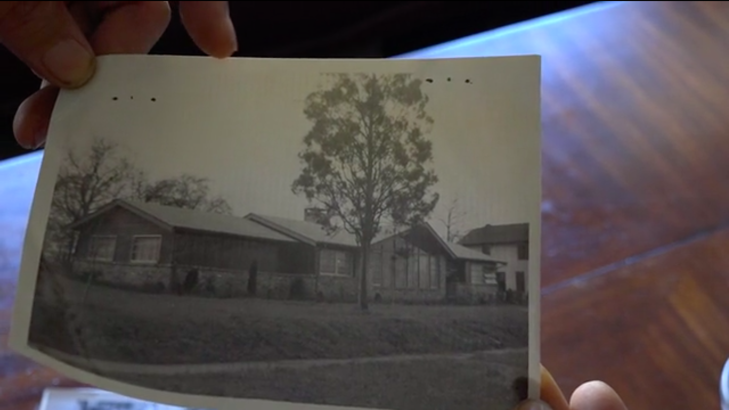
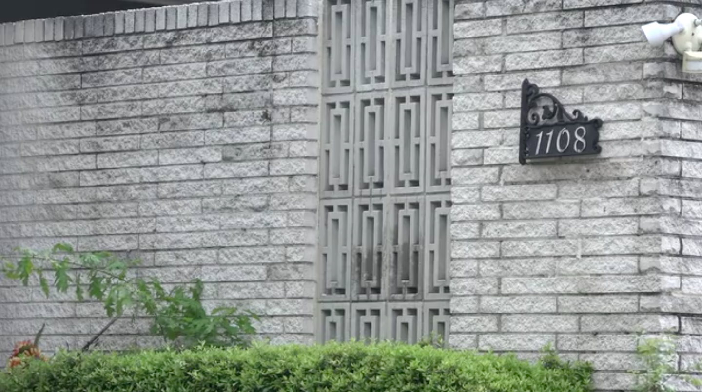
The original street-facing window of 1108 was a grand, cathedral-style frame—a colossal opening into a living room where the organizers met. Shot at and shattered countless times, the scenic window now only exists in photographs. After sustaining several bombings and much gunfire, the Drews had the home rebuilt with a new structure designed to endure bomb blasts. They constructed eight-foot tall brick walls that encased the perimeter of 1108 and reconfigured the interior so that the bedrooms were the furthest away from the street. The walls held and have endured, with the scars of attempted murders visible on the bricks.
The opportunity to hear Jeff Drew's story is a recent development. After Birmingham's 2013 commemoration, Drew told reporters that his parents asked him to never give interviews about "Uncle Mike" for fear that the white press would seek to tarnish his legacy and that of other local Black activists. With time, and the passing of many 1960s movement participants, Drew decided that he would talk more about this history. Seeing Drew outside 1108 talking to whoever will listen is as ordinary as seeing the mail being delivered. The only time he might turn down a conversation would be under similar circumstances to when he had us reschedule: he had a lunch date with childhood neighbor Angela Davis.
Acknowledgements
Special thanks to Jeff Drew for treating strangers like neighbors and taking the time to share his essential story.
About the Authors
Joseph Quintana earned his MA in Communication Studies from the University of Alabama in 2019. He recently received a screenwriting certificate from NYU Tisch School of the Arts and is currently pitching prospective screenplays and researching documentary subjects.
Mary Campbell Kitchens is a graduate from the University of Alabama and works as a secondary math special education instructor in New Orleans, Louisiana.
]]>Video and Essay
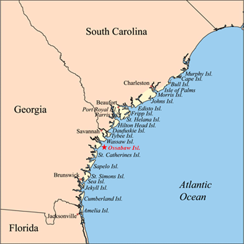
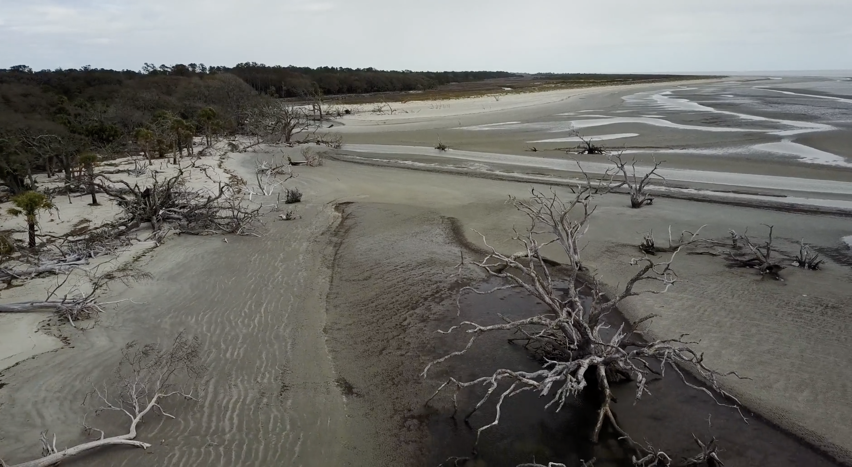
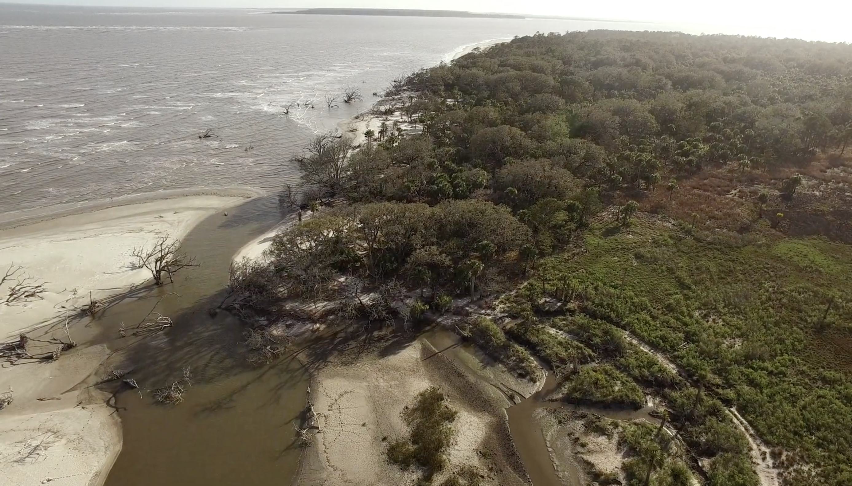
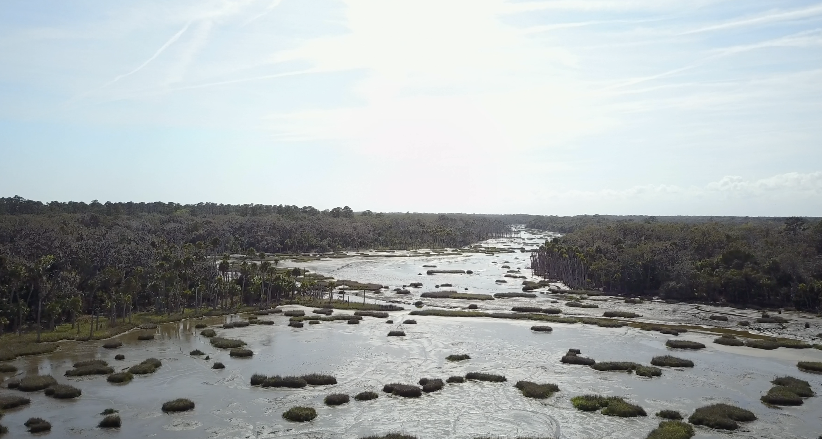
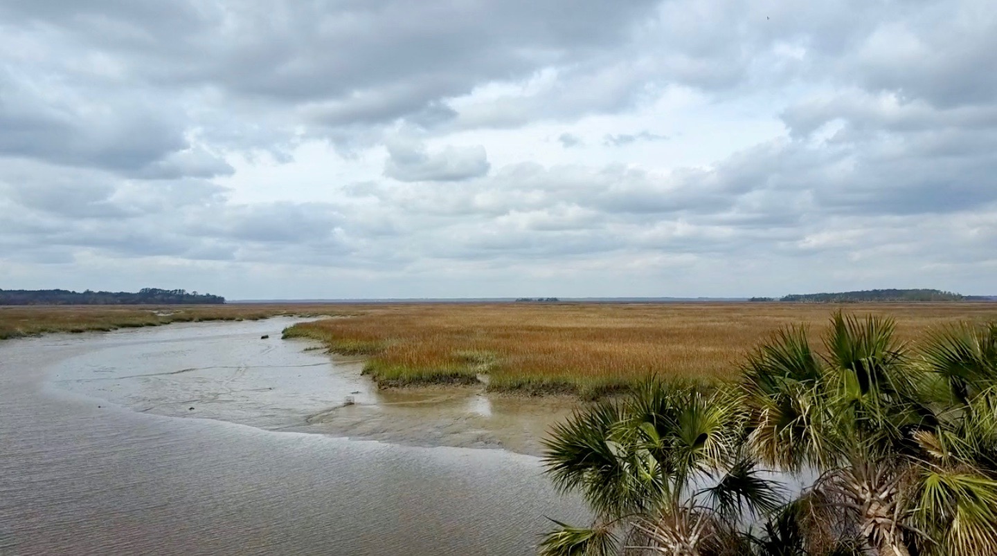
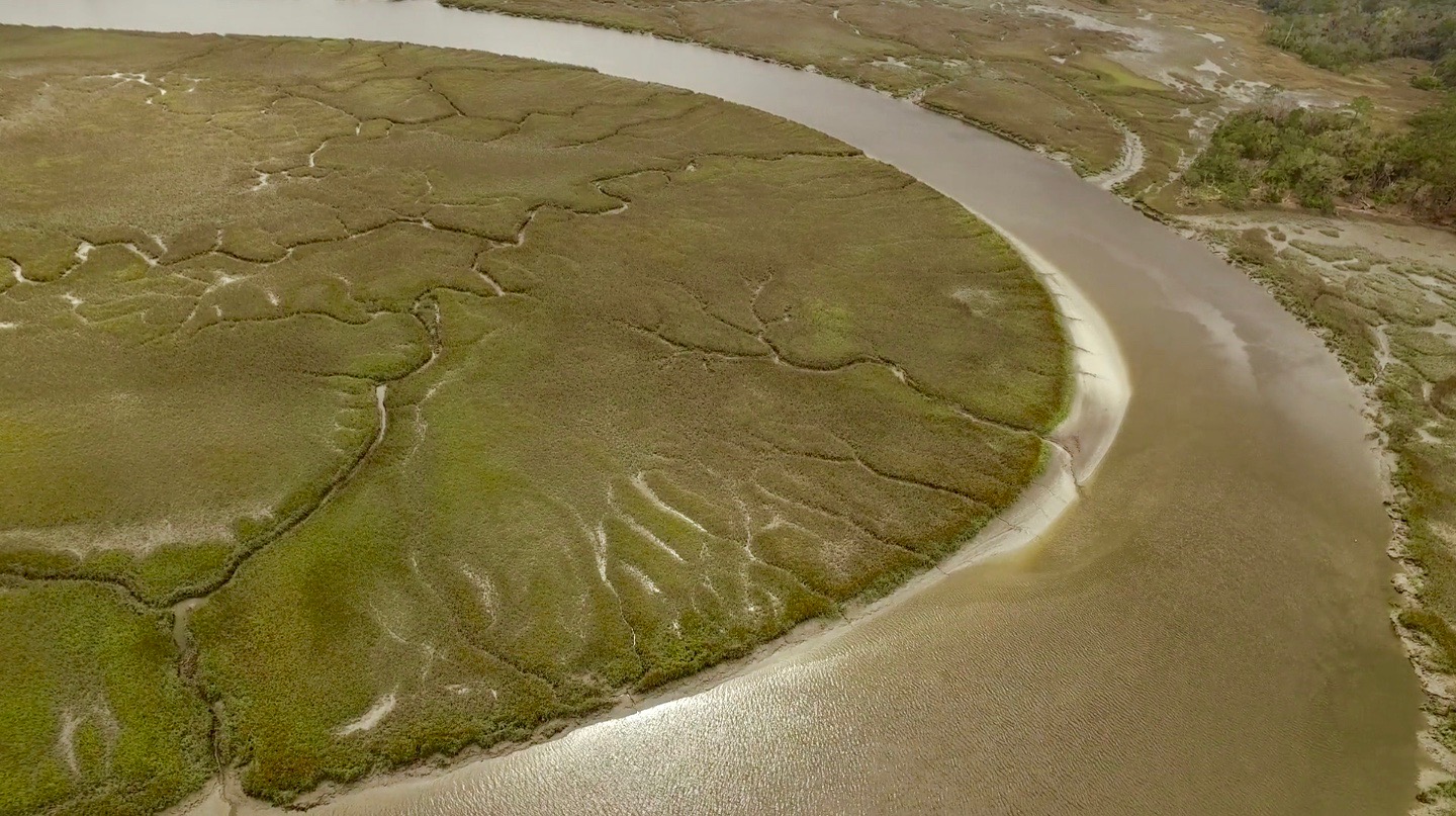
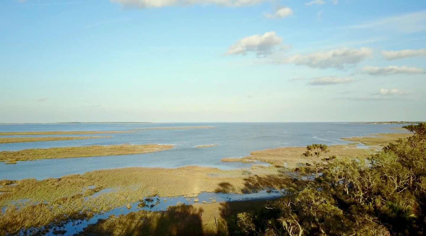
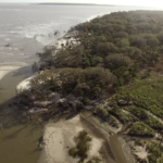
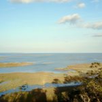
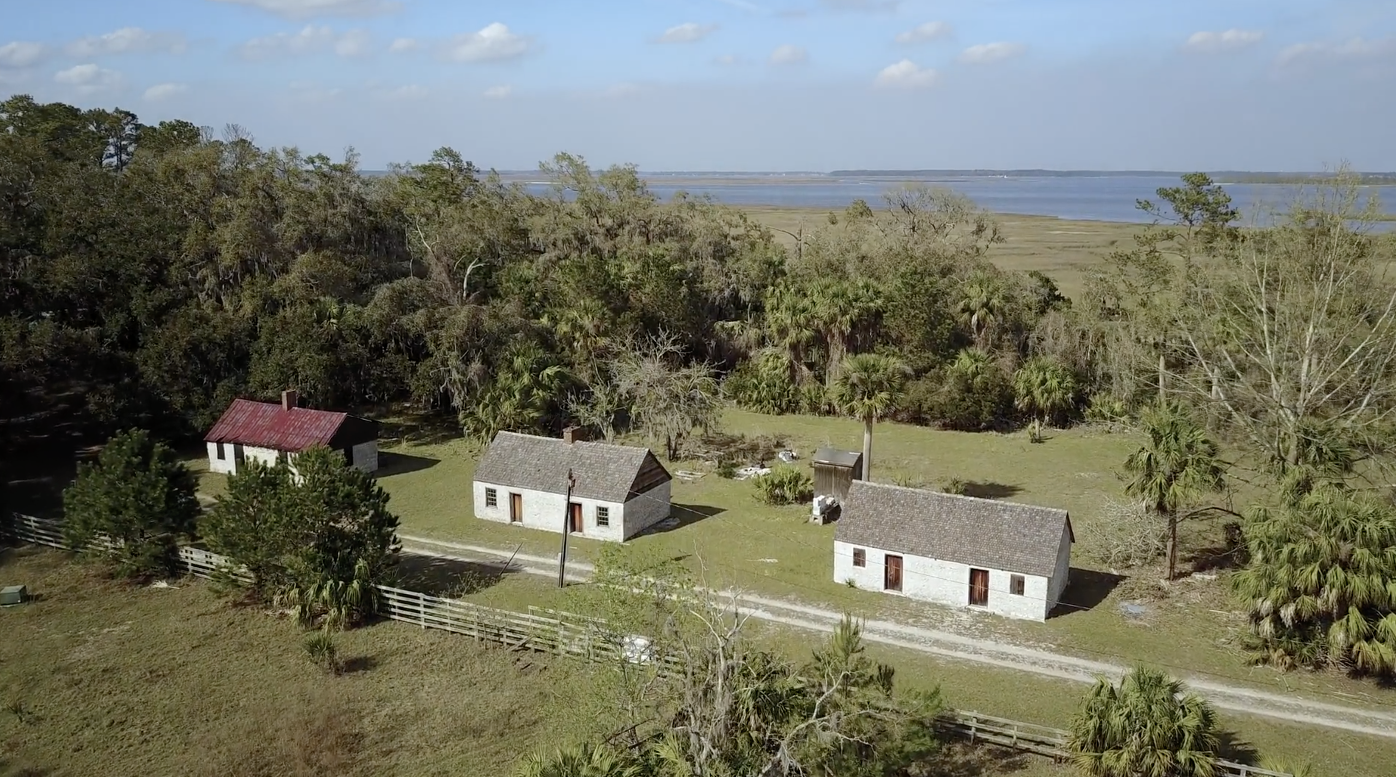
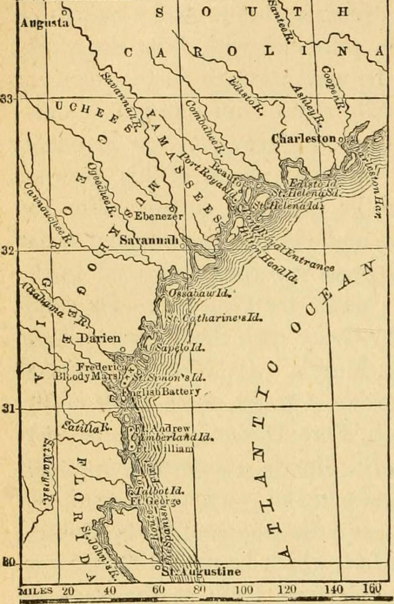
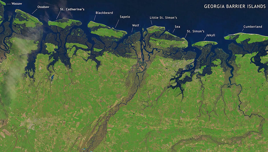
Ossabaw Island is a barrier island on the Georgia coast. The island, which trends northeast–southwest, is about 14.5 kilometers (9 miles) long and 10.5 kilometers (6.6 miles) wide. It is located between latitudes 31° 49.5' and 31° 43.2' N. Of the Georgia barrier islands, Ossabaw is the most geologically unusual. Like the major Georgia islands south of it—Cumberland, Jekyll, St. Simons, Sapelo, and St. Catherines—Ossabaw is a composite island, in which sediments from Pleistocene and Holocene shorelines are directly adjacent or superimposed. However, sediments of the Pleistocene (Silver Bluff) and Holocene shorelines on Ossabaw split near its southern portion, with the Pleistocene trending north–south and the Holocene trending northeast–southwest. The modern shoreline, which formed only in the past few thousand years, wraps around the southern and northeastern corners of the island.
Ecosystems on Ossabaw include salt marshes, maritime forests, beaches, and a few freshwater ponds. Salt marshes are widespread west of Ossabaw, but also occupy much of the middle and eastern parts of the island between sediments of the Pleistocene and Holocene shorelines, dividing its maritime forests. The climate of Ossabaw is temperate to subtropical, with temperatures ranging from an average high of 32° C (90° F) in the summer to 10° C (50° F) in the winter. Average rainfall is about 50 centimeters (20 inches) per year, with most precipitation during the hurricane season (May–September). Hurricanes have rarely affected the Georgia barrier islands until recently, when Ossabaw was hit by Hurricane Matthew (2016), then later Hurricane Irma (2017). Hurricane Matthew, in particular, uprooted many of the older live oaks on the island and otherwise dramatically altered its landscape.
Although Ossabaw is often labeled as "pristine," humans have transformed its landscapes for at least 4,000 years. Its human history is similar to that of its island neighbor, St. Catherines, beginning with Native Americans (the Guale). The Guale had occupied Ossabaw since about 2000 BCE, but European colonization began when the Spanish arrived in the late sixteenth century. A lasting remnant of Spanish colonization on Ossabaw is the presence of feral hogs, some of which are linked to Spanish stock. This relatively large population of hogs has disrupted or otherwise altered ecosystems throughout the island.
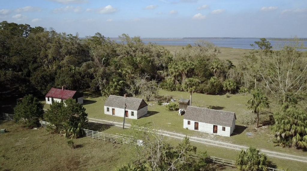
The British took control of Ossabaw in the 1730s, by which time the Guale had mostly moved inland or suffered near extinction under the pressure of colonization. Early treaties reserved Ossabaw as hunting and fishing ground for the Creek people until 1758. The British also began enslaving African people for their plantation economy, and in the late eighteenth century American settlers continued using enslaved people as laborers for growing cotton and indigo. Most inland ecosystems of Ossabaw, especially the maritime forests and salt marshes, were altered considerably by this agriculture. Following the American Civil War, a significant population of African Americans stayed on the island, but most moved to the mainland after the Sea Island Hurricane of 1893. Many of their descendants today comprise the Gullah-Geechee community in Pin Point, Georgia.
Through the early to late twentieth century, Ossabaw's ownership changed several times, but the island remained largely undeveloped and sparsely inhabited. The last private owners were members of the Torrey family, starting with Dr. Henry Norton Torrey and Nell Ford Torrey, and ending with their daughter, Eleanor Torrey ("Sandy") West. The Torreys oversaw the building of a large home for themselves, as well as hunting lodges, a beach house, and unpaved roads. In 1961, after Sandy West inherited the island, she and her husband Clifford West began the Ossabaw Island Project. This project brought luminaries of the arts and sciences to the island as a retreat center for study and discussion; notable participants included composer Aaron Copeland, writers Ralph Ellison, Margaret Atwood, and Annie Dillard, as well as ecologist Eugene Odum. This creative initiative also resulted in the Genesis Project, which focused more on the natural sciences and hosted scientists for on-site studies of and education about the archaeology, ecology, and geology of the island.
In 1978, Sandy West sold Ossabaw to the state of Georgia to establish it as the state's first heritage preserve, and it has been managed since by the Georgia Department of Natural Resources (DNR). The Ossabaw Island Foundation was established afterwards as a non-profit organization working with DNR to encourage educational, cultural, and scientific programs on the island. Sandy West continued living on the island until just recently; at the time of this writing (January 2020), she was living in nearby Savannah, Georgia, and had just celebrated her 107th birthday.
This Ossabaw flyover video provides a visual sample of the many interconnections between natural and human histories on Ossabaw. Featuring sweeping aerial views and audio annotations explaining the island's varied environmental features, this video is organized around four sequential but overlapping themes: fauna, flora, landscapes, and human structures.
Acknowledgment
Thanks to the Ossabaw Island Foundation for their support on this piece.
About the Authors
Anthony "Tony" Martin is a professor of practice in the Department of Environmental Sciences at Emory University. His publications include Life Traces of the Georgia Coast (Bloomington: Indiana University Press, 2013).
Steve Bransford is the senior video producer at the Emory Center for Digital Scholarship. His documentary feature film The Well-Placed Weed is available on the PBS website and app.
Michael Page is lecturer in Geospatial Sciences and Technology at Emory University.
Leotie Hakkila is an MPH student at the Rollins School of Public Health, Emory University.
Anandi S. Knuppel is a visiting assistant professor in the Department of Religious Studies at Lawrence University.
]]>Introduction

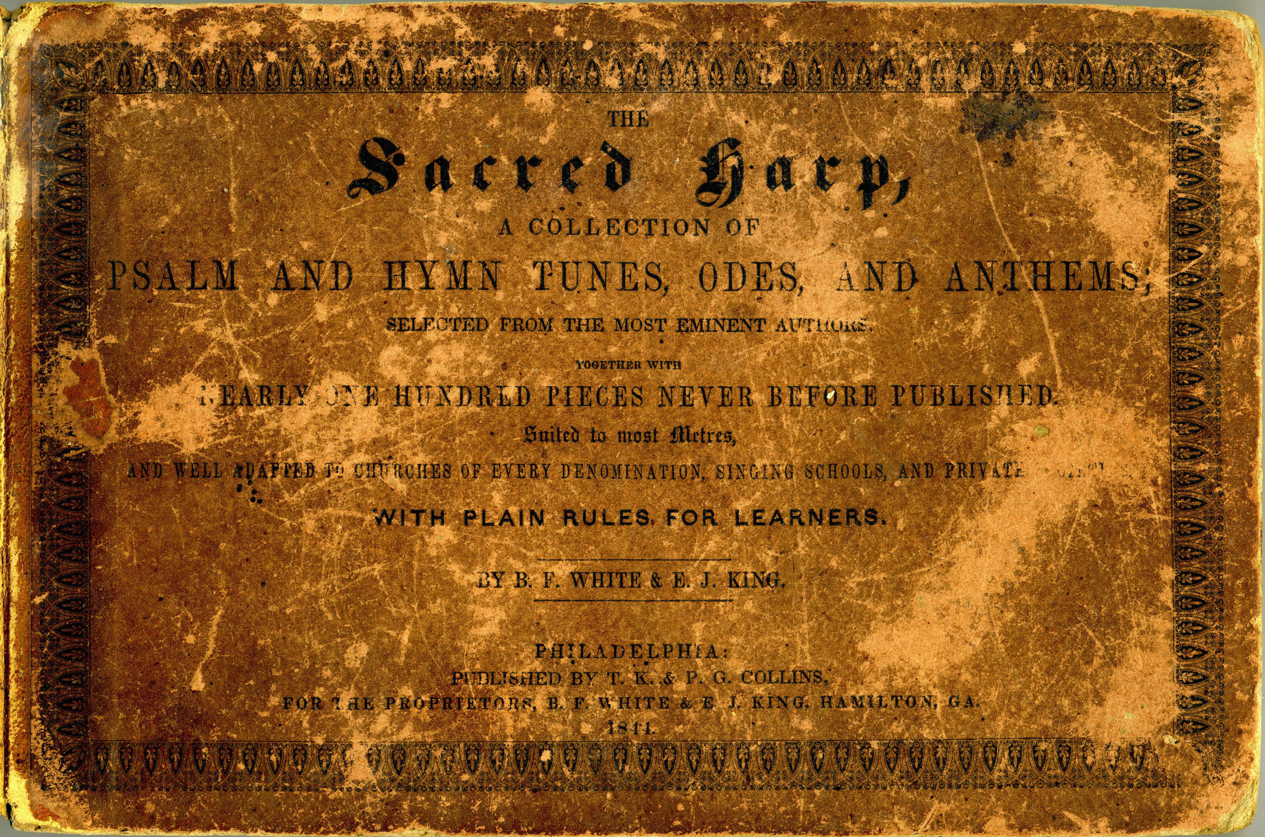
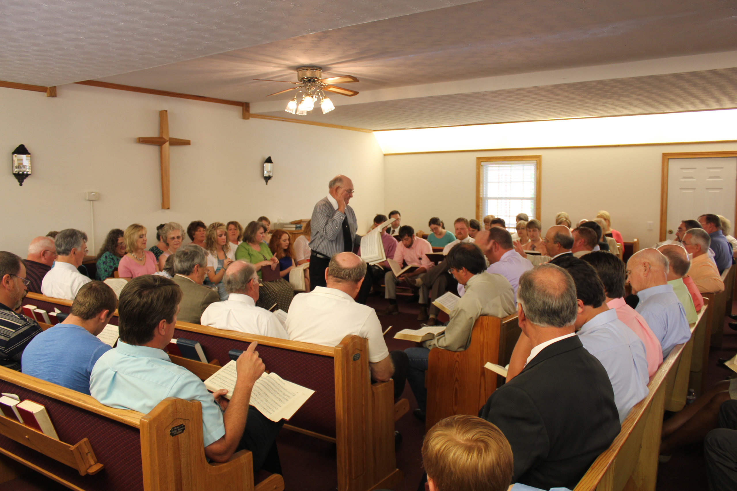
Sacred Harp singing is defined by its spatial organization as much as by its musical style. In this form of shape-note music, an assembled "class" of singers gathers at annual events called "singings"—weekend days spent in churches or community centers singing songs from The Sacred Harp, a nineteenth-century Georgia tunebook revised every generation or so. The tunebook uses a pedagogical system in which the music's note heads have four distinct shapes corresponding to their position in the scale, associated with the names "fa," "sol," "la," and "mi," which singers recite before singing a song's hymn text. Just as important as the shape-notes to the Sacred Harpers is the "hollow square" orientation in which singers sit, facing each other in rows of pews or chairs organized by voice part (bass, alto, treble, and tenor). Throughout the singing day, a procession of leaders take turns stepping into the hollow center to face the tenor or lead section that carries the melody and direct the class in a song or two of their choice from The Sacred Harp.1For more on Sacred Harp singing, see, especially, Buell E. Cobb Jr., The Sacred Harp: A Tradition and Its Music (Athens: University of Georgia Press, 1989); John Bealle, Public Worship, Private Faith: Sacred Harp and American Folksong (Athens: University of Georgia Press, 1997); Kiri Miller, Traveling Home: Sacred Harp Singing and American Pluralism (Champaign: University of Illinois Press, 2008); David Warren Steel and Richard H. Hulan, The Makers of the Sacred Harp (Champaign: University of Illinois Press, 2010).
For singers, the hollow square is both a practically necessary convention and a deeply meaningful space. Encircled by full-voiced singing to hymn texts such as Isaac Watts's "Within Thy circling pow'r I stand, On ev'ry side I find Thy hand," for singers the immersiveness of the hollow square comes to represent God's encompassing love.2"Akin," music by P. Dan Brittain (1971), words by Isaac Watts (1719), in Hugh McGraw et al., eds., The Sacred Harp: 1991 Edition (Carrollton, GA: Sacred Harp Publishing Company, 1991), 472. For composers, the spatial organization of singings, especially the separation of voice parts, is something to consider and emphasize in writing for the tradition. For singers and scholars seeking to capture the essence of Sacred Harp singings, the hollow square has been a longstanding focus, with advances in recording technology leading to new strategies. In this publication we introduce new immersive 360-degree video and audio recordings we made from within the hollow square in the summer of 2019 and offer context drawing on a larger project about the hollow square's meaning to singers and composers and the history of attempts to capture the experience of this unique sonic space.
Yi Halo and Ambeo VR at Mt. Lebanon
We used new video and audio recording technologies to capture elements of the experience of the hollow square. Our recording equipment included the Yi Halo, a device that captures video via seventeen separate cameras arranged in a circular housing. The Google platform Jump Assembler (now defunct) stitched the footage from all the cameras into a series of 360-degree videos.3Janko Roettgers, "Google Is Shutting Down Its Jump VR Video Program," Variety (blog), May 18, 2019, https://variety.com/2019/digital/news/google-jump-shutting-down-1203219306/. We used the Sennheiser Ambeo VR microphone to capture 360-degree spatial audio via four interconnected microphone capsules. Using the video editing application Adobe Premiere, we connected the 360-degree video to the spatial audio. When the user shifts the 360-degree visual field of view in the YouTube window, the audio shifts correspondingly. This spatial audio can only be experienced when wearing headphones.
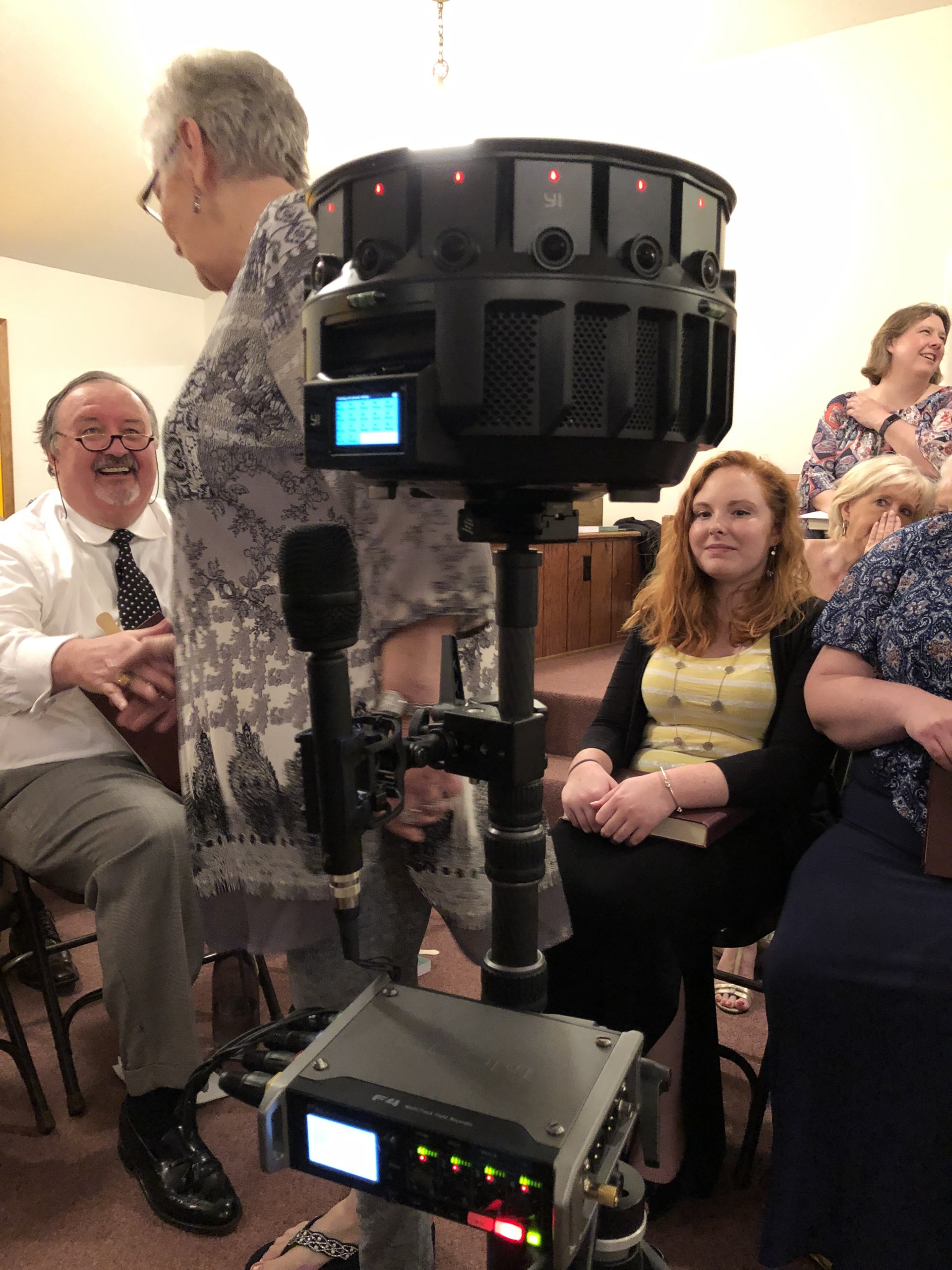
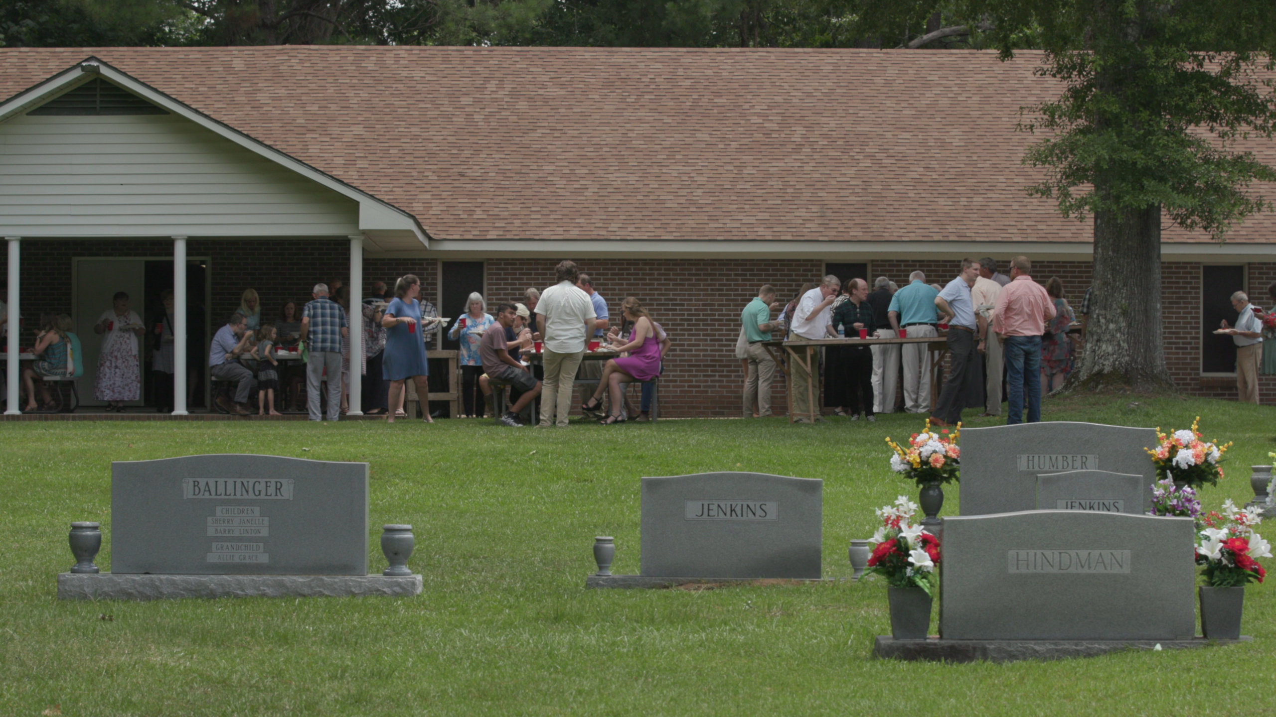
After trying out the device at a Decatur, Georgia, all-day singing, we recorded three hours of the annual singing at Mt. Lebanon Baptist Church in rural Fayette County in west Alabama. This lively, midsize singing is in an area long central to the geography of what is now an international music culture with roots in Alabama, Georgia, Mississippi, Florida, and Texas.4On Sacred Harp's shifting geography, see James B. Wallace, "Stormy Banks and Sweet Rivers: A Sacred Harp Geography," Southern Spaces, June 4, 2007, https://southernspaces.ecdsdev.org/2007/stormy-banks-and-sweet-rivers-sacred-harp-geography; Jesse P. Karlsberg, "Folklore's Filter: Race, Place, and Sacred Harp Singing" (PhD diss., Emory University, 2015), https://etd.library.emory.edu/concern/etds/n009w256n?locale=en; Jesse P. Karlsberg and Robert A. W. Dunn, "Mapping the 'Big Minutes': Visualizing Sacred Harp's Geographic Coalescence and Expansion, 1995–2014," Southern Spaces Blog (blog), January 23, 2018, https://southernspaces.ecdsdev.org/2017/mapping-big-minutes-visualizing-sacred-harps-geographic-coalescence-and-expansion-1995-2014. The Mt. Lebanon Singing also serves as this Independent Baptist church's homecoming and as a reunion for the Ballinger family, a number of whose members are active singers. Today the singing also attracts members of singing communities in northeast Alabama, metro Atlanta, and further afield: singers in 2019 had traveled from New York City and Dublin, Ireland, to Fayette County. Trying the singers' patience and good humor, we placed the cumbersome, many-eyed Yi Halo in the singing's cozy hollow square for much of the day. Song leaders stood right next to the device. Steve captured conventional "flat" video from the back of the room, behind the tenor section, while Jesse sat and sang with the tenors.
The resulting recordings, embedded in this publication and accessible through YouTube, present video and audio from the center of the hollow square. This vantage point, typically inaccessible to those who don't lead songs, is the physical and spiritual center of Sacred Harp singings.
Entering the Hollow Square
The hollow square is central to understanding the music and music culture that surrounds The Sacred Harp. Singers associate the hollow square with key values of participation and community. Sacred Harp singers often state that they are "singing for each other and for God," rather than for an audience. Though non-singers such as family members and descendants of singers, congregants at churches hosting singings, and other curious individuals do sometimes come to listen, the layout of Sacred Harp singings, in which singers face each other rather than the listeners in the back, reinforces its participatory ethos.5On how Sacred Harp's spatial organization compares to that of historically related sacred music cultures, see Paula Tadlock, "Shape-Note Singing in Mississippi," in Discourse in Ethnomusicology: Essays in Honor of George List, ed. Caroline Card et al. (Bloomington: Ethnomusicology Publications Group, Indiana University, 1978), 191–207.
The hollow square also bolsters singers' sense of Sacred Harp as a community. Eye contact across the hollow square, where trebles face basses and tenors face altos, has kindled relationships, reinforced friendships, and intensified shared emotional experiences. Sacred Harp's music culture generally discourages talking while a singing is in session. In the absence of commentary on the affective and spiritual experience of singing, nonverbal communication—during singing and between songs as leaders cycle in and out of the square—contributes to singers' understanding of their experience as shared.6On verbal and nonverbal communication, the hollow square, and affective intensity in Sacred Harp singing, see Miller, Traveling Home; Kiri Miller, "'Like Cords Around My Heart': Sacred Harp Memorial Lessons and the Transmission of Tradition," Oral Tradition 25, no. 2 (2010), http://muse.jhu.edu/journals/oral_tradition/v025/25.2.miller.html; Anne Heider and R. Stephen Warner, "Bodies in Sync: Interaction Ritual Theory Applied to Sacred Harp Singing," Sociology of Religion 71, no. 1 (2010): 76–97.
The hollow square also improves the sound of Sacred Harp singings in ways both practically and aesthetically valued by singers. Facing each other makes it easier for singers to stay together. All can see and follow the leader, who beats time, moving an arm down and up to convey tempo. Singing at each other rather than out at an audience concentrates sound, making it easier for singers to hear each other. The accumulated volume enhances the depth of the experience.
Of course, the very best sound is in the center of the hollow square. In this space, the singing is loudest and all four parts achieve their best balance. Many singers who came to Sacred Harp singing as adults remember the first time they stepped into this space as the time they knew Sacred Harp singing would become an enduring part of their lives. Over time many come to think of this locus of Sacred Harp's spatial organization as a sacred space. Singers frequently invite newcomers to join them in the center for a song, believing that this is the best vantage point from which to apprehend what makes the music culture so moving to its participants.
Composing Sacred Harp's Spatiality
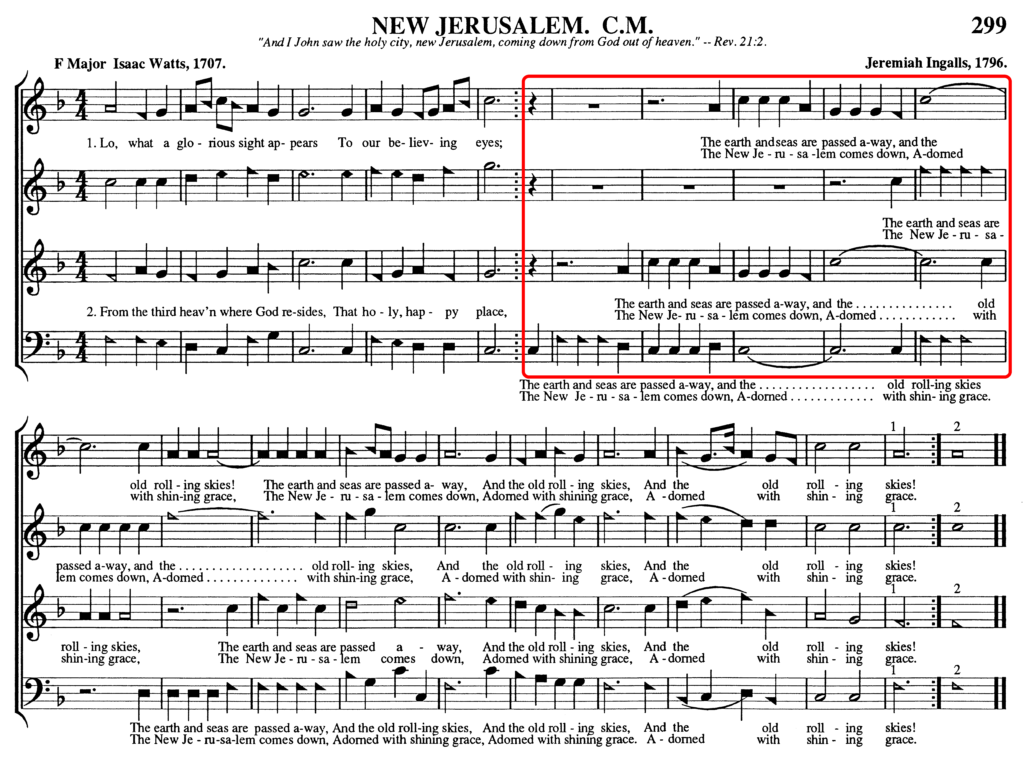
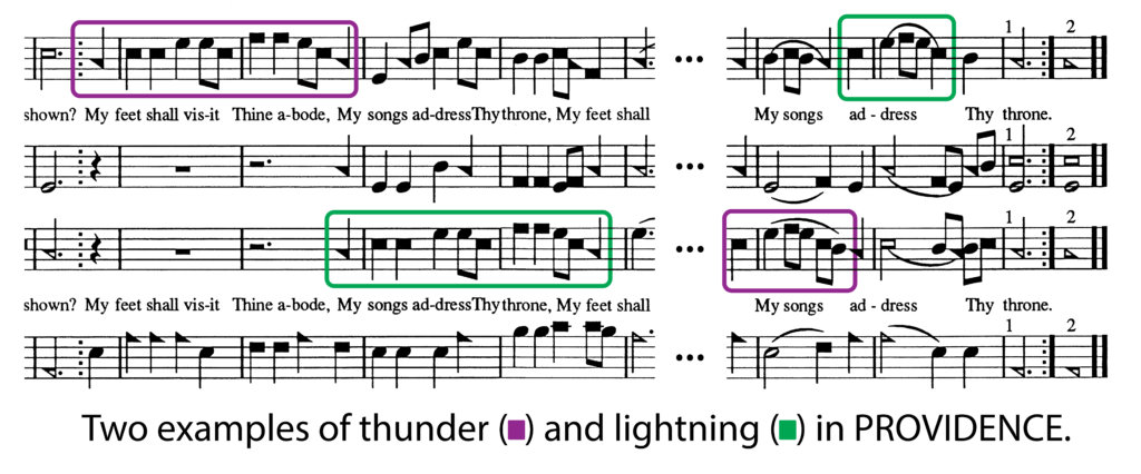
Many of the songs in The Sacred Harp leverage specific features of the hollow square for musical and emotional impact. The three immersive recordings of the Sacred Harp singing at Mt. Lebanon feature songs exemplifying two such approaches: fuging among the voice parts and traded high notes between the tenor and treble parts. Fuging tunes are among the most characteristic and popular song forms in The Sacred Harp. Typical fuging tunes begin with all the parts singing together, followed by a section in which each of the four voice parts enters in sequence, finally coming together again before the conclusion of the song.7Irving Lowens, "The Origins of the American Fuging Tune," Journal of the American Musicological Society 6, no. 1 (April 1, 1953): 46, https://doi.org/10.2307/829998. On fuging tunes, see also Karl Kroeger, American Fuging-Tunes, 1770–1820: A Descriptive Catalog (Westport, CT: Greenwood Press, 1994); Maxine Ann Fawcett-Yeske, "The Fuging Tune in America, 1770–1820: An Analytical Study" (PhD diss., University of Colorado at Boulder, 1997); Jesse P. Karlsberg, "Genre Spanning in the Close and Dispersed Harmony Shape-Note Songs of Sidney Whitfield Denson and Orin Adolphus Parris," American Music 35, no. 1 (2017): 94–132. The most common of these entrance patterns, as found in Jeremiah Ingalls's "New Jerusalem," led by Eli Hinton of Atlanta, Georgia, is propelled forward not just by the cascade of entrances and their progression from lower to higher voices, but by their spatialization. The entrance pattern proceeds counterclockwise around the hollow square, with basses followed by tenors, trebles, and altos.8"New Jerusalem," music by Jeremiah Ingalls (1796), words by Isaac Watts (1707), in McGraw et al., The Sacred Harp, 299.
Generations of composers have adopted this pattern and experimented with alternatives, frequently inspired by the arrangement of the vocal parts around the hollow square. After a short fuging section, Amos Munson's "Newburgh," led by Cheyenne Ivey, a member of a singing family from Henagar, Alabama, leverages the physical separation of the vocal parts to dramatize the celestial distance between the sun and stars. After the basses to the right of the leader enter on the phrase "Thou sun with golden beams" and all four parts sing "And moon with paler rays," the trebles, to the leader's left, reply with a shimmering "Ye starry lights, ye twinkling flames, Shine to your Maker's praise."9"Newburgh," music by Amos Munson (1798), words by Isaac Watts (1719), in McGraw et al., 182.
Composers also rely on the separation of vocal parts to create moments of power and energy by trading prominent high notes in rapid succession between the tenor and treble parts, a feature that singers often refer to as "thunder and lightning." Since these two parts are typically sung by mixed gender groups with similar vocal ranges, this trading back and forth of high notes would be undetectable without the vocal separation that the hollow square provides. In songs like C. Curtis's "Providence," led here by siblings Wanda Capps and Danny Creel from Dora and Hoover, Alabama, respectively, the traded high notes are distinct and clearly audible, contributing dynamic crackling energy to the song. "Providence" features "thunder and lightning" in multiple places. After a short opening section, the song's chorus begins with the trebles singing a musical phrase that peaks on a high note (accompanied by the basses) which is immediately echoed by the tenors. The song continues with similar exchanges, culminating in a figure ricocheting from the tenor to the treble as the song reaches its conclusion.10"Providence," music by C. Curtis (1820), words by Isaac Watts (1719), in McGraw et al., 298.
Recording the Hollow Square
For singers and scholars, Sacred Harp's spatial qualities have made recording the style appealing. Yet the results have persistently struck their makers and audiences as falling short of conveying the experience of being at a singing. The earliest field recordings, made by John W. Work III in 1938 and Alan Lomax and George Pullen Jackson in 1942, used then-available monophonic technology, collapsing the music's richly spatialized four-part harmonies to a single channel of recorded sound.
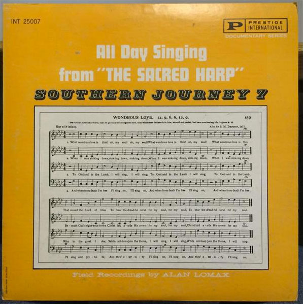
For Lomax, frustration with the result prompted him to include Sacred Harp singing in his itinerary for the "Southern Journey" field recording sessions he conducted in August through October of 1959 after he first gained access to portable stereo recording technology. The ensuing recordings, released in part as All Day Singing from "The Sacred Harp" (1961), provide considerably greater depth and intimacy than the monophonic recordings from the 1930s and 1940s, and contributed to greater public awareness of and interest in participating in Sacred Harp singing during the folk revival.11Alan Lomax and Alabama Sacred Harp Singers, All Day Singing from "The Sacred Harp," recorded 1959, 33 1/3 rpm record, Southern Journey (Bergenfield, NJ: Prestige, 1961). But Lomax's vantage point at one corner of the hollow square contributed to an imbalance among the parts that bothered contemporaneous Sacred Harp singers. The Sacred Harp Publishing Company, publisher of the most widely used tunebook at singings, responded by recording, producing, and releasing a series of LPs in the 1960s and 1970s, recorded in a studio and mastered to provide what they deemed a more satisfying balance of the parts.12Cobb, The Sacred Harp. When quadrophonic sound systems—one speaker for each Sacred Harp voice part!—proliferated in the 1970s, the same organization planned a release in this format, but the project was eventually shelved.
Conclusion
In the 2020s, as in the 1930s, there is no substitute for experiencing a Sacred Harp singing in person; singings today are held across the United States and beyond every weekend of the year. Yet we think the recordings of these three songs provide new virtual access to the experience of Sacred Harp's spatiality. We invite you to explore the activity in different parts of the singing space by shifting your perspective while navigating the video on your desktop monitor or your phone's YouTube app. If you wear headphones, you can hear the spatial audio shift along with the visual field of view. If you have access to a virtual reality headset, you can immersively experience the perspective these recordings afford. We plan to stage virtual reality viewings of these recordings at the Camp Fasola Sacred Harp singing school and at other singings in 2020. We will also make recordings of other songs accessible through the web in the coming months to expand the selection of songs and leaders captured using this technology. 
Additional Videos
- Philip Gilmore, of Oneonta, Alabama, leads Ananias Davisson's "Idumea" (p. 47b) from The Sacred Harp.
- Ewa Lichnerowicz, of Dublin, Ireland, leads S. M. Denson's "Praise God" (p. 328) from The Sacred Harp.
- Cindy Tanner, of Henagar, Alabama, leads George Coles's "Green Street" (p. 198) from The Sacred Harp.
- Beth Wallace, Eady Porter, Aubrey Zeanah, and Ridley Colvin, of Fayette, Northport, and Demopolis, Alabama, lead O. A. Parris's "My Brightest Days" (p. 546) from The Sacred Harp.
- Judy Caudle, of Eva, Alabama, leads H. S. Rees's "Sweet Morning" (p. 421) from The Sacred Harp.
About the Authors
Steve Bransford is the senior video producer at the Emory Center for Digital Scholarship. His documentary feature, The Well-Placed Weed, is available on Vimeo.
Jesse P. Karlsberg is the senior digital scholarship strategist at the Emory Center for Digital Scholarship. He is the project director and editor-in-chief of Sounding Spirit, a research lab and publishing initiative promoting collaborative engagement with historical American songbooks. Karlsberg is an internationally recognized singer, teacher, composer, and songbook editor in the Sacred Harp tradition.
]]>Video and Essay
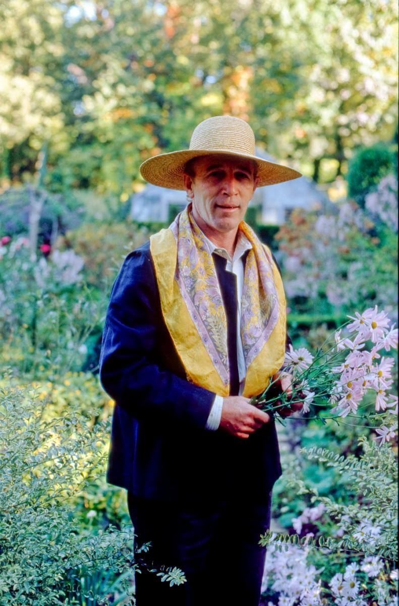
Ryan Gainey (1944–2016) grew up in the Sandhills of South Carolina in the small town of Middendorf, twelve miles north of Hartsville. Born to a working-class family, Gainey picked cotton at an early age with his brothers, sister, and cousins. Through relatives and neighbors, he developed an early love for propagating plants, rooting camellias in Mason jars underneath the eave of a barn (where they could catch the rain), and learning to grow old-fashioned varieties of petunias and roses. In the 1960s, Gainey studied horticulture at Clemson University, served in the Navy, and eventually settled in Atlanta. He opened a series of garden shops in the affluent Buckhead neighborhood that were successful in part because there were few other boutique garden shops in the area at the time. Gainey sourced many of his plants from the Holcombe Nursery in Decatur, five miles east of Atlanta. When he learned that the Holcombe family wanted to sell their property in 1980, he jumped at the chance.
Gainey envisioned a beautiful new garden in the informal cottage style, using the aged brick walls of the old Holcombe greenhouses as the boundaries for a series of "garden rooms." As his creations garnered attention, he received commissions around the city. Although not formally trained in landscape design, Gainey, through self-study and experimentation, developed a distinctive style that combined cottage garden aesthetics and classical English design with a strong reliance on native plants. By the 1990s he'd become internationally renowned, forming friendships with such English gardening notables as Rosemary Verey and Penelope Hobhouse.

Chad Stogner, founder of the garden accessory company Elegant Earth, worked with Gainey in the 1990s and noted that the designer had a way of "making things look spontaneous. . .that were planned." Most gardeners work to eliminate weeds, but Gainey would allow them to pop up in certain areas. To visitors, these would appear as happy accidents, but they were deliberate, as Gainey explained in his 1993 book The Well-Placed Weed from which our documentary takes its title. Gainey's gardens feature a fascinating give-and-take between the structured and the free-flowing.

Gainey chose many of the plants in his garden for their personal and historical connections, such as the chinaberry tree (Melia azedarach), which was a prominent feature in his childhood yard and also was, as he liked to point out, one of Thomas Jefferson's favorite plants. He discouraged gardeners from mimicking the plant choices of classical English gardens and instead championed the use of native southeastern US plants along with plants from similar latitudes in China and Japan.
In March 2016, a 140-year-old white oak tree that had served as the shady anchor of Gainey's Decatur garden fell on his house. At home at the time and miraculously uninjured, Gainey was forced to relocate to Lexington, Georgia, seventeen miles east of Athens where, in July, he died in a fire trying to save his beloved Jack Russell terriers.
We did our first video shoot with Gainey in the spring of 2010. At the outset, we didn't know what we were doing and were content to let him unspool lectures on gardening topics of his choosing: the history of tea olives or figs, blending purple and gold plant colors, and how to maintain fragrance year-round. He thought we were producing a gardening masterclass. None of us thought we were making a documentary.

We became fascinated with the funny moments just before or just after he delivered his monologues—such as when he'd yell at his dogs or tell a dirty joke or make some ridiculous boast. We were drawn to the tangents that floated above and below the persona: his humor, narcissism, and personal connections to plants.
We eventually found structure for the project by developing a series of overlapping threads: Gainey's childhood, his rise as an entrepreneur and social figure in Atlanta, and his wider reputation as garden designer. We were also drawn to his idiosyncratic personality. We witnessed him being prickly and self-absorbed, as well as generous and thoughtful.
There remain gaps in our story. Gainey acknowledged a couple of times on camera that he was gay but never discussed any of his longtime partners in any detail. We tried to steer him to fill in the biographical narrative, but became resigned that there was no directing Ryan Gainey. He served up a vast body of knowledge via his commanding and often contradictory persona. In the end, we did our best to wrangle an honest character study.


We thought we were winding down the project in early 2016 before the tree fell on his house. That event set in motion a string of calamities that culminated in his tragic death. We worked for another year and a half to tidy up the edit and flow before premiering The Well-Placed Weed: The Bountiful Life of Ryan Gainey at a festival in South Carolina in April 2018.
Ryan Gainey made and collected beautiful things. We are grateful that he shared some of these with us and that, through our documentary, we now share this with others.
Visit The Well-Placed Weed's website for more information and to view the documentary in its full length of seventy-eight minutes.
About the Directors
Steve Bransford is the senior video producer at the Emory Center for Digital Scholarship and the founder of Terminus Films. Cooper Sanchez is an artist and garden designer focused on the restoration of historic southern gardens. For ten years, Cooper has been working to rejuvenate the gardens at Historic Oakland Cemetery as well to build his own garden in Clarkston, Georgia.
]]>Video
A Reflection by Craig Womack
A friend of mine tells a story about his high school days in the greater tri-city area (Wetumka, Weleetka, and Wewoka—Creek names for water that roars, runs, and barks—for those of you from parts other than rural eastern Oklahoma). One day in his Weleetka High School class, everyone stopped paying attention to the teacher and turned their eyes from the chalkboard, and United States history, to a Kafkaesque-sized cockroach making his (or her) way leisurely across the classroom floor, giant antennae twitching as it navigated its escape from secondary education.
As all of those in our noble profession know, even the most starry-eyed believer in the power of education sometimes loses control of the classroom, and this particular teacher, upon realizing her lecture had been hijacked by a very large insect, walked over to the uninvited intruder and ground it under the heel of her shoe. Given the size of the cockroach, some cleanup was in order, so she went down the hall to get paper towels from the restroom. On the way back, she heard all kinds of cheering coming from her class. While she had been out, the cockroach had reanimated and was making a second beeline, so to speak, for the door. If not for her puzzlement over all the commotion, the teacher might have nailed it again, but the cockroach reached safety, while all the Indian kids in the class cheered it on!
I don't care to judge the historical veracity of this wonderful tale, but it seems to me the Mvskoke Creek language might have about as much chance for survival as that cockroach, and I will leave it up to the reader, and the film viewer, to interpret whether or not I am suggesting that a miracle is needed or that miracles sometimes occur.1The official name of the tribe located in present-day Oklahoma is the Muscogee Creek Nation. The word, in the language, for what Creek people speak is "Mvskoke," pronounced the same as the word for the tribe. Some Creeks prefer the name "Mvskoke" since "Creek" is a name given to the tribe by the English in the Colonial era.

For sure, the dominating force of English surrounds us. People in Creek country say there are five thousand Creek speakers left, but nobody seems to know where that number comes from, and many suggest there are only a few hundred speakers, some even far fewer. This documentary, Hearing the Call: The Cultural and Spiritual Journey of Rosemary McCombs Maxey, features a Creek community leader who is determined to speak the Creek language every day—to people, when possible, and to llamas, chickens, cats, and dogs, when not.
Four years ago, I was approached by Stefanie Pierce, at that time the administrative assistant in the Department of Environmental Sciences at Emory University, who said she was talking to people about making a documentary on Rosemary. The project immediately struck me as having merit, because women in the Creek Nation are seldom given public recognition for their knowledge and contributions, especially in the realm of language and culture where women have been both instrumental as well as often ignored. In Rosemary's case, as Hearing the Call attests, she possesses multi-generational knowledge about community genealogies predating Creek Removal from ancestral homelands in Alabama and Georgia in 1836 as well as a command of specific family histories in Oklahoma Creek churches that goes back to the 1840s, when her family first started becoming leaders in these places of worship. Add to this her history working in Indian Country outside the Creek Nation, among Lakota people in South Dakota, for example; as an advocate for Native Hawaiian prisoners incarcerated in Oklahoma and Arizona; as an interim pastor for a year at Community of Hope, Tulsa's GLBTQ church; as a pastor of various United Church of Christ congregations on the East Coast; and as a person in critical dialogue with leading feminist, race, and theological scholars in the 1970s and 1980s, and it becomes evident that the subject of our documentary has more stories than we could ever put up on the screen.

As I, along with Rosemary herself and a group of Creek language advocates, watched the story unfold when Hearing the Call premiered at Emory earlier this year, it felt like its own kind of coming out story, albeit in this case the story of a kid who, rather than announce to her parents she is gay, instead tells them she's called to be a preacher—even though no such role exists for women in the denomination she grew up in. What strikes me as an incredible act of the imagination seems like something else the way Rosemary tells it: being around preachers was the only thing she knew, so as far back as she can remember she practiced sermonizing on farm animals. I don't know if Rosemary would have ground the cockroach into oblivion, had it shown up during one of her childhood church services on back porches and in farm wagons, but, having known her for many years, I feel confident that it wouldn't have escaped without being addressed at length in the Creek language, and I don't hesitate to imagine it coming up to the altar to be saved.
What is the Creek language, anyway? Without getting too complicated, let's just say it is one of the original languages of the US Southeast, and since I am an Emory professor, I will add that it is the first and foremost language of the campus where I teach. Creek people lived at Emory's exact location prior to the 1820s, having been forced out of the area earlier before the removal of the main body of the tribe that occurred in 1836, the year of Emory's founding. When I am on campus, therefore, I simply have to look where I am stepping if I want to know where the Creek language originates.
The language was originally spoken throughout Alabama and Georgia, and in the late 1700s and into the early decades of the nineteenth century, it spread into Florida through Creek-speaking groups that migrated there and now live on the Seminole reservations and elsewhere in Florida. In 1836 when the tribe was forcibly removed from Alabama and Georgia to the present-day state of Oklahoma, the language moved into what was then known as Indian Territory, a sovereign entity set aside for the exiled tribes sent there. Today, the language is primarily spoken by Oklahoma Creeks, Oklahoma Seminoles, and Florida Seminoles.


The first university course in the Creek language took place at the University of Oklahoma in the fall of 1991. As fate would have it, I was in that course. A non-Indian graduate student in anthropology, Pam Innes, was the instructor of record, and she was working with the Creek ceremonialist Linda Alexander and her daughter, Bertha Tilkens, both active members of Greenleaf Ceremonial Ground. I remember three things very vividly from that first effort. First, a Creek/Comanche friend of mine, who sat next to me, would rail after every meeting: "How can we have this non-Indian, who doesn't speak the language, trying to teach us how to speak Creek?" I didn't feel inclined to disagree. Secondly, there was constant writing and erasing, the instructors' hands working at cross-purposes, as Pam would write down a verb she had Linda conjugate, then leave it on the board; the next time Linda conjugated the verb it would be totally different, due to the infinite contextual factors that change Creek verbs. Thirdly, though we had no cockroaches for entertainment, Linda had her own way of hijacking a classroom through hilarious and raunchy stories that I have never quite gotten over and hope I never will. I am happy to report that the collaboration between Pam, Linda, and Bertha evolved into a respectful and reciprocal alliance, a friendship I have always been grateful to have been caught up in.
Since these tenuous beginnings, when academics were speculating about how Creek language worked, often relying on the meticulous fieldwork of the linguist Mary Haas, who worked in Oklahoma in the 1930s, and basing their guesses on Mary Haas's guesses, the Creek language has come a long way in terms of formal analysis. A significant part of the progress has involved checking and analyzing this earlier linguistic work with a large cohort of contemporary Creek speakers.
.")
Pam Innes's collaboration produced a Creek grammar—Beginning Creek: Mvskoke Emponvkv (Norman: University of Oklahoma Press, 2004)—which followed a Creek-English dictionary published in 2000 by the linguist Jack Martin, who worked collaboratively for a decade with Creek elder Margaret Mauldin. By the new millennium, classes had spread from the University of Oklahoma to Oklahoma State, campuses where significant numbers of Creek students are enrolled. Martin's own work would expand tremendously with grammars, Creek-to-English translations of stories, innovative interviews of Creek elders by other Creek elders in the Creek language, videos of Creek Christians singing hymns in Creek, and much more.
While all of this has gone on at the level of formal study, the community's ability to produce young Creek language speakers is a dire situation. The tribe faces two major challenges: getting long-term immersion programs started, and the even more daunting chore of creating environments where immersed kids have some place outside the immersion classroom to practice their language skills. It is simply a fact that young kids surrounded constantly by a second language will learn it, but how do you create people for them to speak with? Can this really be done? In comparison, the cockroach might have had it easy.
Questions abound. Numerous tribes no longer have any native language speakers. Does this mean the tribe no longer has an easily definable cultural identity, or can they find new ways to identify as Indian? What, exactly, is contained in language, and to what extent do non-linguistic factors also carry culture? To what degree can English, a language spoken by almost every Indian in the United States and English-speaking Canada, also be considered an Indian language at this point? What does the Chickasaw poet Linda Hogan mean when she writes, "[b]lessed are those who listen / when no one is left to speak"?2Linda Hogan, "Blessing," in Calling Myself Home (New York: Greenfield Review Press, 1978), 27.

Rosemary McCombs Maxey still has people to talk with in Creek, farm animals who get dinner and a language lesson at the same time, Skype meetings with Creek academics in which we work together on bringing increasing levels of Creek language into our writings, and many other ongoing conversations throughout Creek country. We listen, and, since we come from a culture that prizes call and response, we hope to echo back some of what she has taught us. As for our cockroach, I don't know if it had anything akin to a language, but it did have witnesses who wanted it to survive, and we hope Hearing the Call bears witness to the power of resistance and continuance.
About the Directors
Craig Womack is an Oklahoma Creek-Cherokee Native American literary scholar, writer, and teacher, and an associate professor of English at Emory University. He is the author of Red on Red: Native American Literary Separatism (1999), Drowning in Fire (2001), and Art as Performance, Story as Criticism: Reflections on Native Literary Aesthetics (2009). He is co-author of American Indian Literary Nationalism (2006) and Reasoning Together: The Native Critics Collective (2008). He is currently working on a novel about a young musician in Northern Minnesota and his obsession with the Oklahoma folk singer Woody Guthrie. Steve Bransford is a Senior Video Producer at the Emory Center for Digital Scholarship.
]]>Video and Essay
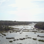
A barrier island on the Georgia coast, Sapelo has an unusually long and varied blend of natural and human history. The western half of the island is composed primarily of Pleistocene sediments deposited along a shoreline 40–50,000 years ago. Much of its eastern half is more recently formed and dynamically shifting. Modern ecosystems include extensive salt marshes with tidal creeks, beaches, maritime forests, back-dune meadows, grasslands, and a few human-made freshwater ponds. Erosion occasionally reveals sediments from older environments, such as hundreds-year-old relict marshes exposed along Cabretta Beach on Sapelo's northeastern edge.

Sapelo Island in the Sea Islands Watershed. Courtesy of Wikimedia Commons. Creative Commons license CC BY-SA 2.5.
The Sapelo climate is temperate to subtropical; temperatures range from an average high of 90°F (32° C) in summer to 50°F (10° C) in winter. Freezing is rare. Rainfall is about 50 inches (127 centimeters) a year, with the majority of precipitation during the May–September hurricane season. Despite the impact of Hurricane Matthew on October 8, 2016, hurricanes rarely affect the Georgia coast. The worst was in 1898, and directly impacted Sapelo and its companion, Blackbeard Island, to the northeast. Until the 1898 hurricane hit, Blackbeard hosted a US Marine Hospital yellow-fever quarantine station, which was damaged heavily by the storm; it reopened, only to close in 1909 with the development of yellow-fever vaccines.
A prominent and well-preserved Native American (Guale) shellring on the northwestern corner of the island gives evidence that humans have experienced Sapelo for at least 4,500 years. The arrival of the Spanish in the sixteenth century resulted in the naming of "Sapelo," an Anglicized corruption of "Zapala" from Spanish and likely a corruption of the original Guale name for the island. French and English colonization of Sapelo in the eighteenth and nineteenth centuries heavily modified the local ecosystems.
Following the American Revolution, alteration of the local environment continued throughout the early to mid-nineteenth century. Plantation agriculture depended on slave labor of people with varied languages and origins in west Africa, resulting in an enforced cultural mélange. Descendants of those enslaved people, and the only Gullah-Geechee population on any Georgia barrier island, reside today in the Hog Hammock community. Although shrinking in size, Hog Hammock retains a distinctive culture and features a revival of traditional knowledge, including handicrafts such as sweetgrass basket weaving, cultivation of unique agricultural species (e.g., Sapelo red peas), and Gullah-Geechee storytelling.


Top, the UGAMI complex on Sapelo Island, Georgia, 2015. Bottom, lighthouse on Sapelo Island, Georgia, 2015. Screenshots courtesy of Southern Spaces.
Perhaps the most scientifically significant legacy of Sapelo is its birthing of modern ecology, much of which was done at the University of Georgia (Athens) Marine Institute, or the UGAMI, founded in 1953. The UGAMI owes its existence to ecologist Eugene Odum (1913–2002) and tobacco heir/businessman R.J. Reynolds, Jr. (1906–1964). Reynolds bought most of the island in 1934, but Odum persuaded him to donate land and buildings to start the UGAMI in 1953. The Institute, located next to its study sites, has conducted world-renowned research on salt-marsh ecology and other aspects of natural communities on and around the island.
Reynolds' widow, Annemarie Reynolds, sold much of the island to the state, which the Georgia Department of Natural Resources now manages. The western edge of Sapelo is part of NOAA's National Estuarine Research Reserve system, termed the Sapelo Island National Estuarine Research Reserve. The UGAMI still serves as a thriving center for ecological research and hosts academic field trips in natural science education.
In September, November, and December 2015, we visited Sapelo Island to gather ground and aerial drone-video footage that would visually summarize its ecosystems. This footage also shows signs of human activity, such as the UGAMI complex, paved roads, a freshwater pond created by excavation, and the present-day lighthouse, still used for guiding maritime traffic in Doboy Sound.

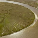
Internal Waterway, Sapelo Island, Georgia, 2015. Screenshot courtesy of Southern Spaces.
Our first trip in September 2015 also coincided with "king tides," spring tides accentuated by a relatively stronger gravitational pull associated with a "super moon." This situation caused unusually high tides to flood marshes, roads, and other low-lying places on Sapelo, a phenomenon repeated there and along the rest of the Georgia coast in late October 2015. Tidal ranges on the Georgia coast are already greater than those of most barrier island systems, typically varying from 2.5–3 meters (8.2–9.8 feet). Any addition to this already-voluminous water exchange imparts dramatic effects. Some of the drone footage showing the extent of the flooding serves as a harbinger of predicted sea-level rise on the east coast associated with climate change. We also included two snippets of time-lapse sequences of intertidal areas—Cabretta Beach, on the northeastern corner of the island, and a salt marsh in the south end—to further convey the effects of tides on island margins and interiors.
This Sapelo video encapsulates a history that forecasts the future under climate change. Among its subjects are: abrupt transitions in coastal ecosystem, from beach to back-dune meadows to maritime forests; beaches where sand is being actively eroded or deposited by longshore drift; a tree "boneyard" with dead trees on a beach signaling the former presence of a maritime forest; an artificial freshwater pond adjacent to maritime forest but with salt marshes in the background; dendritic drainage patterns of marshes at low tide, and much more. Despite its short 3:45-minute length, this video's content, combined with its brief narrated descriptions, can inspire an hour or more of classroom discussion of natural and human systems on this remarkable Georgia barrier island.
About the Authors
Anthony (Tony) Martin is a professor of practice in the Department of Environmental Sciences at Emory University. His publications include Life Traces of the Georgia Coast (Bloomington: Indiana University Press, 2013). Steve Bransford is an educational analyst for video with University Technology Services at Emory. He launched his own production company, Terminus Films, in 2001. Anandi Salinas is a PhD candidate in religion at Emory and a training specialist with the Emory Center for Digital Scholarship. Michael Page is lecturer in geospatial sciences and technology at Emory. Shannon O'Daniel is an educational analyst with Emory's Library and Information Technology Services.
]]>Video and Essay
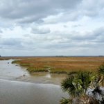
One of the barrier islands along the Georgia coast of the Atlantic Ocean, St. Catherines has an extraordinary ecological and settlement history. First inhabited more than four thousand years ago, the undeveloped island is privately owned but protected for the public good. A small network of unpaved roads connect the interior of the ten-mile long, three-mile wide island. In addition to ongoing environmental study, extensive archaeological research has occurred at St. Catherines with regard to Native American settlements, the Spanish mission of Santa Catalina de Guale, and pre-Civil War plantation sites.
 |  |
During a week-long visit to St. Catherines in March 2015, Emory University geographer Michael Page, environmental scientist Anthony (Tony) Martin, and graduate student Alison Hight flew a camera-bearing drone over nearly every type of ecosystem on the island: maritime forests, extensive beaches, back-beach meadows, salt marshes, mud flats, fresh-water ponds, and more. Along with colleagues from Georgia Southern University, Page and Martin have worked together at St. Catherines since 2011, locating, describing, mapping, and writing about alligator dens and gopher-tortoise burrows. The use of a drone enables a new way of studying the island's dynamic ecosystems and scouting locations difficult to reach on foot. During their spring 2015 trip, Page and Martin found places where alligators walk from their dens through nearby salt marshes, then return. Rather than trying to track the alligators in the marshes—a challenging, time-consuming, and risky endeavor—they sent the drone to take overhead photos at higher resolutions than currently available imagery from the US Department of Agriculture and other agencies. Page and Martin georeferenced and mosaicked the captured images for their research geodatabase. In addition to demonstrating the potential of a drone in difficult-to-access areas, Page and Martin plan to use the St. Catherines video footage to teach students how to identify and interpret the environments of a Georgia barrier island, and to conduct local-scale mapping.
From the many hours of March 2015 drone footage, documentary videographer Steve Bransford edited the short video presented here. It begins by orienting viewers to the location of St. Catherines, and then travels smoothly across the various ecosystems. The former site of the Spanish mission is visible (its footprint outlined by cabbage palms) as are alligator tracks, and alligators swimming near the video's end.
About the Authors
Steve Bransford is an educational analyst for video with University Technology Services at Emory University. He launched his own production company, Terminus Films, in 2001. Anthony (Tony) Martin is a professor of practice in the department of Environmental Sciences at Emory University. His publications include Life Traces of the Georgia Coast (Bloomington: Indiana University Press, 2013). Michael Page is lecturer in geospatial sciences and technology in the department of Environmental Sciences at Emory University.
]]>Video
Charles D. Thompson, Los Rostros del Tiempo: Faces of Time, 2014.
Reflection
My border odyssey began in 1985 on a farm near Pittsboro, North Carolina. On a hot summer afternoon I walked out of my farm field to meet five men from Mexico. They drove into my driveway in an old beat up blue Impala, got out in the bloodied knee-length white coats and black rubber boots they'd worn that day in the nearby chicken processing plant, and said they had heard I needed help harvesting blackberries on my farm. As I reached to shake their hands, I felt a powerful sense of relief wash over me. I felt like crying.
I had been successful enough with my farm marketing that there was no way I could pick everything I could sell. Orders had piled up, and the farmers' market was just a few days away. The small group of helpers I'd found for one or two days a week earlier in the summer—three high school students and occasionally one of their grandmas who drove them to the farm—had drifted away to other jobs, from fast food work to babysitting. My wife worked off the farm. My neighbors were all either too old or too busy. I had no extended family nearby. Interns hadn't yet started searching for opportunities on farms. I was doing most everything alone, and there just weren't enough hours of sunlight to get all of the two acres of ripe berries harvested. Soft small bramble fruits are especially vulnerable to heat and they weren't going to wait.
 |
I'd already known that Mexican people, men mostly, had started coming to central North Carolina. I knew many of them processed hogs or poultry, and that others worked on dairy or tobacco farms nearby. I'd even gone to Mexico once the year before. But I never dreamed when I went into small-scale organic farming that I'd ever hire laborers to help me, let alone foreign workers.
Yet, on that hot afternoon thirty years ago, I joined the thousands of farmers and other business owners who have hired people who have traveled some three thousand miles and crossed a desert or a river to save their day and ours. They would only work a few hours two or three times a week for me, but they made it possible for me to salvage my blackberry crop, some of my most important income of the year. Choosing to be paid by the flat, they earned pretty good money, too. They literally ran to the fields that day to get started filling the pints as I carried them empty flats and returned with filled ones to the cooling shed.
Over the coming weeks and months we often worked side-by-side. I took a dictionary to the field and began learning Spanish. Already a lover of stories, I wanted to know how they had traveled from their homes and what it was like to cross the border. I learned firsthand about their harrowing journeys and of the risk to provide money for their families. I also learned that every one of those five men were farmers with families still on their land trying to hold on and grow crops in their absence.
We had a love of farming in common. But it hit me hard when I realized that one huge chasm between us was my freedom to stay in place and their need to leave home to keep their farm alive. I was a beginning farmer hiring seasoned agriculturalists from another country to help make my piece of land more profitable. The disparity began to weigh on me.
 |
Thirty years later, I look back to the day the border first crossed me. That day I began to learn that I was caught up in a globalizing system of economic exchange and interdependency. That day I became part of the process too many have dismissed and not enough acknowledge. Since then, I've studied Spanish formally, gone to graduate school, engaged in fieldwork in Mexico and Central America, written about farmworkers, and made films about immigration and agriculture. The borderlands overtook me personally and professionally. I cannot escape their meaning—not just down at the southern line below the United States, but the little borders everywhere in our lives, the borders especially between the people we depend on in so many ways and the policies that vilify them. I now teach and write about all of this, traveling extensively so I can learn and teach others. My own farm is but a memory.
My latest book, entitled Border Odyssey: Travels Along the U.S./Mexico Divide, is a memoir, a travelogue, an ethnography, history, and, as one reviewer put it, a jeremiad about the border. I chronicled every mile of it from the mouth of the Rio Grande in Texas to the Pacific Coast in California. The website and book featured here are my effort to forge better understanding. And the project is also my tribute to Eusebio, Librado, Faustino, Juan, and Jesus, the five who drove in my driveway, saved my blackberry crop, and changed me forever.
About the Author
Charles D. Thompson, Jr. is Professor of the Practice of Cultural Anthropology and Documentary Studies at Duke University. An author and filmmaker, Thompson's latest works are Border Odyssey: Travels along the U.S./Mexico Divide (University of Texas Press, 2015), the films Faces of Time and Brother Towns/Pueblos Hermanos, and the book Spirits of Just Men: Mountaineers, Liquor Bosses, and Lawmen in the Moonshine Capital of the World (University of Illinois Press, 2011).
]]>