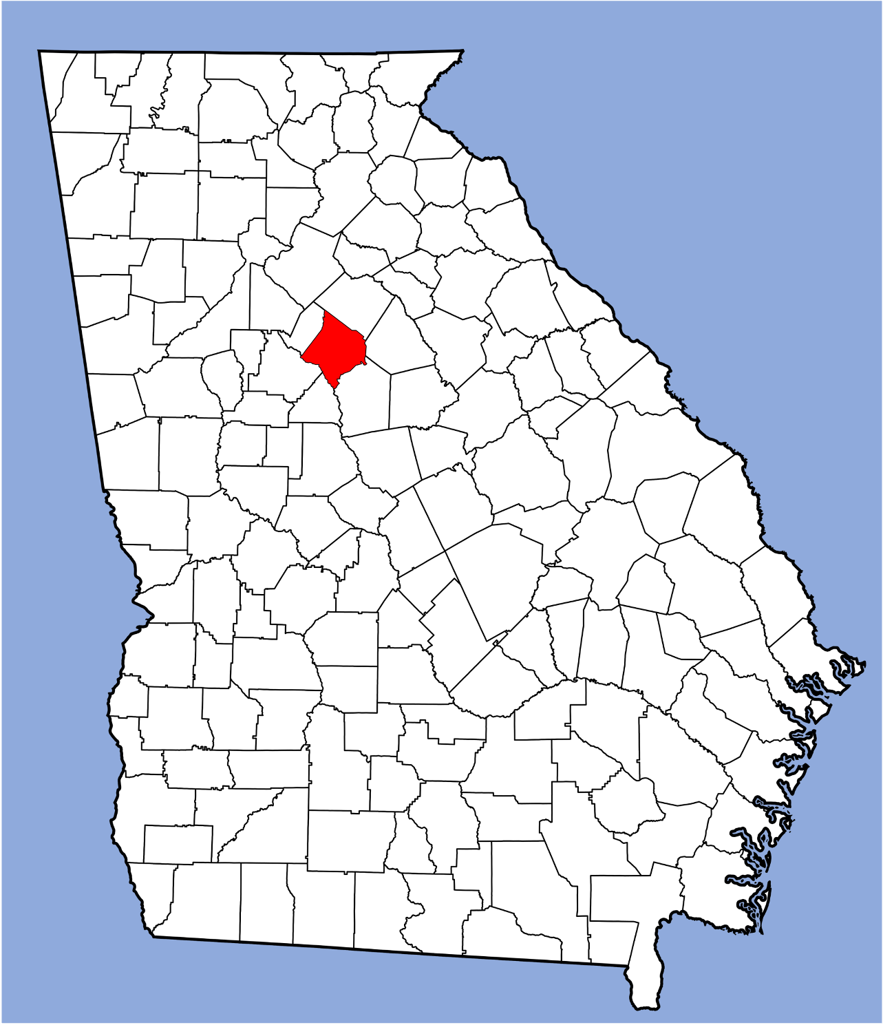
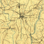
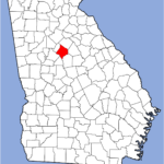
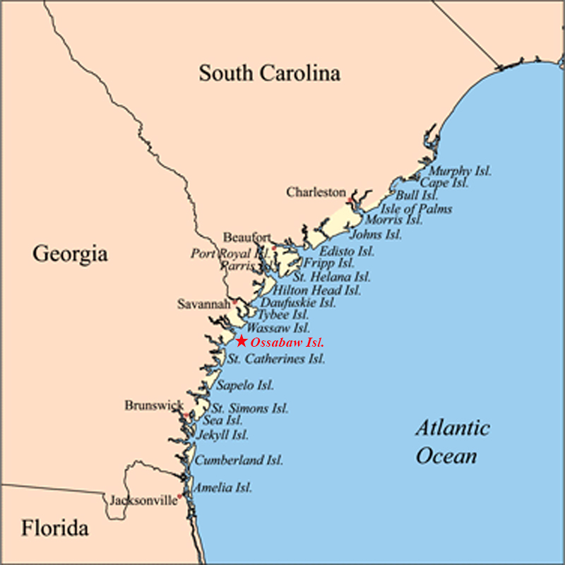
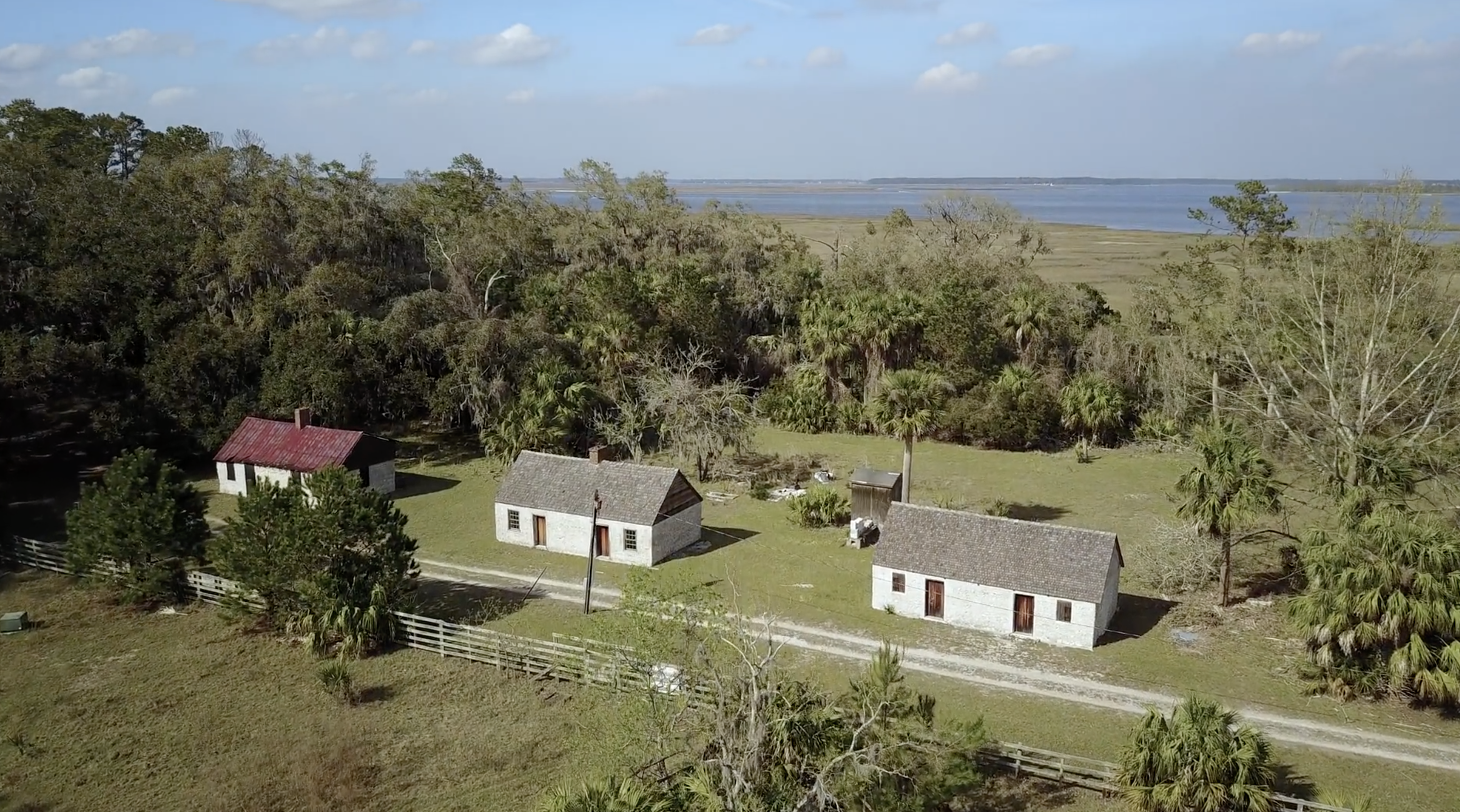
For generations, African American families in Newton County, Georgia have told a haunting story about a tributary of the Yellow River known as "Dried Indian Creek," which meanders about ten miles through the municipalities of Oxford and Covington. The creek passes about a half mile east of the original campus of Emory College—founded in 1836, now known as Oxford College of Emory University—and directly past Bethlehem Baptist Church, the county's oldest African American house of worship. For two centuries the waterway has been a significant site of fishing, trapping, hunting, gathering, reflection, baptism, and recreation for the county's Black residents.
Local Black families are well aware of the white narrative about the name of the creek, published in multiple sources across the decades: when settlers came into the lands that would become Newton County (founded in 1821), they encountered the mummified remains of an individual, whom they assumed to be Native American, and named the waterway "Dried Indian Creek." This version was often told by the segregationist sheriff of Newton County, Henry ("Junior") Odum, (1915–1976), whose grandfather had established "Avon Indian Farm" near the creek. In Sheriff Odum's telling, the mummified Indian was discovered "stretched out under a big old tree."1Odum's account is quoted in a laudatory article about the sheriff in the Atlanta Journal Constitution, 26 May 1968, p. 172.
The African American narrative is different. Elders we have known recalled that when they were children in the 1930s, their elders told them that the creek's name bore witness to a terrible crime. When whites arrived, a courageous Native American leader refused to leave the land his people had long resided on.2We assume this Indigenous leader was Muscogee, but the older African American oral accounts we heard referenced him as "Indian" or "Native American." White settlers seized, beat him, strung him up, and left his body dangling over the water, not allowing anyone to cut him down until his corpse had dried. As the story was told, this early spectacle lynching was staged as a warning to Native and enslaved Black people that any challenge to white rule would be swiftly and violently put down.
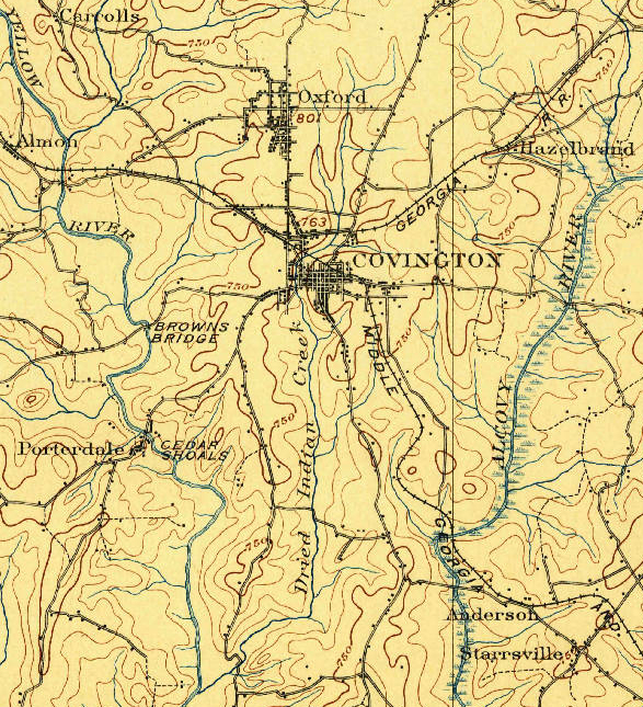
We know of only one white-authored account. The June 4, 1893, Atlanta Constitution reports that a Mr. W.D. Boggus of Covington has a number of curiosities on display in his place of business, including ". . . the leg bone of the Indian chief who was hung in 1795 and left to dry, near the old mill here in town, and from which incident Dried Indian Creek got its name."3Newspaper accounts from the following year state that Boggus wore a ring made from the "bone of an Indian warrior," exhumed from a plundered burial site near Covington (Macon Telegraph, 16 March 1894, p. 4). The individual in question, Woodson D. Boggus (c. 1868–1936), worked in the early twentieth century in Waco, Texas and in Payne, Oklahoma as an oil lease broker before returning to his home state of Georgia. (During the mid-1790s the area that is now Newton County was contested between Muscogee (Creek) inhabitants and encroaching white Georgians.) The Constitution article references the former site of Floyd's Mill, near where Bethlehem Baptist Church now stands, just north of the Clark Street bridge over the creek.
Overlapping Presences: Indigenous and Enslaved
No one we have spoken with recalls the name of this murdered Indigenous man, but the elders shared the belief he was distant kin to many African American families in Oxford. Most of these families trace their descent to two enslaved Native individuals, whom they believe to have been Muscogee (Creek). Cornelius Robinson (born c. 1836) was the enslaved valet of Alexander Means (1801–1883, Emory's professor of natural sciences, who during 1854–1855 was the College's president). Angeline Sims (born c. 1835) was enslaved with her husband George Washington Sims and their children, by Richard Sims, a founding member of Emory College's board of trustees and a founding commissioner of the town of Oxford. Angeline's daughters mainly remained in Oxford and married into local families; nearly every long-term African American family here traces descent back to one of these "Sims" women.
The elders knew that nearly all Muscogee (Creek) had been forced off the local lands around the time of the founding of Newton County, traveling to Alabama and points west, in some cases bringing with them their enslaved people of African descent. Yet they also insisted that not all "Indians" had left, that some intermarried Native and Black families had continued to live in the area.4Newton County, Georgia—created December 24, 1821, from Henry, Jasper, and Walton Counties—was based in three ceded Native territories. Under the terms of the 1805 Treaty of Washington, the 1818 Treaty at Creek Agency, and the 1821–25 Treaty of Indian Springs, all Muscogee lands in Georgia were ceded.
The late educator Emogene Williams (1931–2020), her mother "Miss B," and great-grandmother Sarah Baker Nelson recalled that there was an informal "Indian settlement" to the west of Covington, near Turner Lake, which persisted into the early twentieth century, when the Indigenous people were finally forced off the land. (As they remembered, there were also "gypsies" living in this settlement, who were also forced by whites to leave.) Local historian Johnny Johnson recalls that his grandmother Odessa Smith Gaither, born in 1885, shared stories about Native Americans who passed through Newton County when she was a girl, settling for a while and then "moving on."
A cluster of Afro-Native families continue to reside, semi-autonomously, along the Alcovy (Ulcofauhatchee) River, a couple of miles east of Oxford. (Large Creek villages are known to have been based along this watercourse in the eighteenth century.)5The 1805 Treaty of Washington between the United States and the Creek Nation references the "Ulcofauhatche" river; the term was used through the nineteenth century and was later anglicized to the "Alcovy" River. RaeLynn A. Butler, manager of the Historic and Cultural Preservation Department of the Muscogee Nation, notes that the Mvskoke spelling of the river would be: "orko ofv hvcce," meaning Pawpaw ("Orko," pronounced oth-go), river, or stream. Non-natives, she explains, must have heard "al-co" when mvskoke speakers were saying "oth-go" (RaeLynn A. Butler, personal note to author). See also Jonathan S. Tonge, Ulcofauhatchee: A Guide to Life Along the Alcovy River. Covington: Georgia Wildlife Federation, 2011. This small community of Angeline Sims's collateral descendants, her descendants recall, lived along the Alcovy upstream of the railway trestle, and defined themselves as "Indian" well into the twentieth century.
The late John Pliny ("J.P.") Godfrey, Jr. (1936–2020), great-grandson of Angeline, often visited this settlement of his kin when he was a child in the late 1930s and early 1940s. They trapped, fished, and minimized interactions with local whites. He remembered the elders would sing beautiful songs as they gazed out along the water, with words that were a mixture of English and "old Indian." The songs reminded him of "old Negro spirituals," but were somehow different. He sometimes understood them to be singing in remembrance of the ancestor, the old chief, who had been hanged by whites over the nearby stream and left to dry in the sun. Yet, he recalled, he never heard these elders express bitterness. "They just told me they were singing to help keep the waters rolling along." He smiled, "That's what they felt. Singing somehow helped the river, while the river gave them life and shelter."
Years later, J.P. and Mark walked along stretches of the river, but could find no trace of the old settlement he recalled from his childhood. "It's as if they were never here," J.P. sighed.
J.P and his cousins noted that most Black people in Oxford didn't talk much about their Indian relatives, but he did remember a story about his great aunt Minerva, Sallie's sister. "She was very strong willed. One time, she took her whole family down to live in Louisiana, in 'Ouachita' . . . She used to tell her children there was once a great city there, long before white folks ever came to America. They built pyramids there, just like the ancient pyramids." Records suggest that Minerva, her husband Tom Anderson, and their children lived in Ouachita from around 1890 to around 1908, when they returned to live in Oxford.
Years later, we read about archaeological excavations conducted in Ouachita, Louisiana, indicating that middle archaic mounds and earthworks at Watson Brake dated to at least 3400 BC. J.P. wondered just how Minerva could have known what she had known.
Founding Act of Murder
From time to time, the story of the murder at Dried Indian Creek has resurfaced in our conversations about the early history of Emory College and Oxford, where so many ancestors of local African Americans had been enslaved from 1836 until the end of the Civil War. Deacon Forrest Sawyer, Jr.—who had led the movement for desegregation in Newton County in 1970, famously defying Sheriff Junior Odum—said of Dried Indian Creek, "This county was founded with an act of murder. They were demonstrating the price that would be paid by anyone, red or black, who dared oppose white rule."
Emogene Williams, who traced her descent back to early enslaved persons and white slaveowners in Newton County (and who was the mother of this essay's co-author Rev. Avis Williams) concurred, "That is how they kept power in this county, through public demonstrations of violence, going all the way back to Dried Indian Creek. Lynchings, public executions of Black men scheduled as Black people were filing by going to church on Sunday."
J.P. Godfrey, Jr., whose grandfather Israel Godfrey had worked the land around Oxford in slavery and freedom, remarked, "I don't think it was entirely coincidental that Emory was founded right in the shadow of where that Indian chief was murdered . . . They wanted to show that they had taken hold of this land, and what would happen to anyone who opposed them."
These elders drew a direct link from the public desecration of the body of the murdered Indigenous man in the 1820s to the July 1946 mass lynching by about fifteen white Klansmen of two young African American couples at Moore's Ford on the banks of the Apalachee River in Walton County, which sent terrible shockwaves through surrounding Black communities in the early postwar period.
As Deacon Sawyer put it:
Rivers are the life blood, the arteries, of our land here. Rivers and streams were sacred for Indians, and it was those same creeks we'd steal away to, to feel the flow of the Holy Spirit—from the day we were brought to this county in chains. Of course, white folks chose to torture and kill our people along the river bank, reminding them that nothing was sacred. Any bond of family, any tie of love, could be broken in a moment. That's what white power was back then, and it still is.
Distant Kin: Black Oxford and the Creek Freedmen
These elders had long been fascinated by the stories of the Creek Freedmen, descendants of persons enslaved by Creek slaveowners, who had lived in Georgia and Alabama and then been removed to Indian Territory, later known as Oklahoma. Although there is no direct evidence of common ancestry between Oxford's present-day African American residents and the Creek Freedmen of Oklahoma, many local Oxford Black elders have felt a deep sense of moral kinship with the Freedmen. J.P. Godfrey, Jr., noted, "I know in my heart, those are our people. They were taken from these lands, suffered in ways we can't even imagine, but they endured. They're still our kin."
For J.P. and Emogene Williams, the 1979 de-citizenship of Creek Freedmen—descendants of those who had been enslaved by Creek slaveowners—was particularly painful. As J.P. remarked, "So many thousands gone from here. We had hoped our kin, though in bondage to the Creek, would have finally found a safe harbor in Oklahoma. Now we hear they were expelled, for supposedly being 'too African' . . . For our folks, you might say, the trail of tears never ended."6The precise motivations behind the 1979 changes in the Muscogee Constitution remain deeply contested. Defenders of the 1979 Constitution maintain the change in tribal citizenship was motivated by a desire to recognize only those Creek persons with sufficient Creek blood quanta as Creek citizens. Creek Freedman activists, in turn, insist the disenrollment of the Freedmen was motivated by racial animus, and illegitimately expelled many people whose ancestors had been considered Muscogee for multiple generations. Emogene observed, "I don't know how we're related, but I know from my mother and great-grandmother our people were all mixed together. It pains us to see those folks out West treated with such disrespect. Just like it was happening to us here."
Community members watch as leading figures in the Biden administration and the Congressional Black Caucus advocate for full citizenship rights being restored to all the Five Nation Freedmen. Secretary of the Interior Deb Haaland in May 2021 approved a revision in the Cherokee Nation constitution restoring citizenship status to Cherokee persons of African descent, and indicated her expectation that Muscogee (Creek), Choctaw, Chickasaw, and Seminole would recognize their "moral and legal obligations to the Freedmen."
By the Rivers of Babylon
In 2021, Emory University hosted a conference devoted to tracing the legacies of enslavement and the dispossession of Native American lands on the grounds that later became the institutions that comprise the consortium "Universities Studying Slavery," including Emory, University of Virginia, the Virginia Military Institute, Georgetown, Rutgers, UNC Chapel Hill, and Brigham Young University.7"Program Schedule." In the Wake of Slavery and Dispossession: Emory, Racism, and the Journey towards Restorative Justice. Emory Libraries. Accessed February 3, 2022. https://libraries.emory.edu/slavery-symposium/program-schedule.html. The conference opened with a painfully beautiful Muscogee hymn, "Espoketis Omes Kerreskos" ("This may be the last time, we do not know"), sung by Chebon Kernell, a mekko or ritual leader in the Muscogee (Creek) tradition, and a prayer by Rev. Avis Williams, an ordained Baptist preacher and daughter of the late Emogene Williams.8"Acknowledging the Ancestors with Readings, Music, and Prayer." Emory University. October 13, 2021. YouTube video. 1:13:29. The blessing and song by Cherbon Kernell and the blessing by Rev. Avis Williams are found at (00:00–11:30). https://www.youtube.com/watch?v=ELGjnpgdgJE&list=PLDSBylqXf9oGHja1c3mknOqz8JcVYMNfT&index=6. "Espoketis omes," which resonates with an African American spiritual, was sung along the Trail of Tears, as Muscogee families, including enslaved persons of African descent, made their way towards an uncertain future in the Indian Territory (Oklahoma).9The history of the song "Espoketis Omes Kerreskos" is explored in the 2014 film This May Be the Last Time (dir. Sterlin Harjo). More broadly, the film engages with the intertwined histories of Scottish Congregational line song, African American spirituals, and Muscogee (Creek) songs. Black spirituals and Muscogee hymns draw upon congregational line or note singing, part of a long musical and spiritual trajectory to maintain community amid wrenching dislocations.
Hearing Chebon sing, Avis was struck by the many parallels to the "sorrow songs" she grew up with in the Black Baptist tradition.10W.E.B. DuBois, "Of the Sorrow Songs," The Souls of Black Folk. Chicago: A.C. McClurg, 1903. Wikisource. https://en.wikisource.org/wiki/The_Souls_of_Black_Folk/XIV. In the first chapter of African Creeks (Norman: University of Oklahoma Press, 2007), Gary Zellar notes that early Christian missionization and evangelism in the Creek Nation in Georgia and Alabama was primarily associated with persons of African descent enslaved in Muscogee (Creek) communities. Had her ancestors and Chebon's ancestors perhaps sung together in the past, before or during the terrors of enslavement, forced removal, and land alienation? She was reminded in particular of Psalm 137: "By the rivers of Babylon we sat and wept/when we remembered Zion . . . our tormentors demanded songs of joy/they said, Sing us one of the songs of Zion!" Her ancestors, she knows, sang songs of sorrow but also of hope, in a strange land. So too, she thought, would Muscogee, including enslaved and free people of African descent, have sung these hymns, along many waterways, as they were expelled from their homelands.
On October 10, 2018, a Muscogee Methodist delegation gathered at the long-ago site of Standing Peachtree (Pakanahuili), the Muscogee (Creek) village that stood where Peachtree Creek enters the Chattahoochee River near present-day Buckhead, in north Atlanta.
They offered a prayer and hymn over the river. In a concluding commentary, Marilyn Cloud explained that in Muscogee tradition, "You add the prayer to the tobacco, because it is sacred. You put the tobacco in the flowing water. Whatever the prayer is that you make, the flowing river carries it."
Recently, we've held conversations about how these long-separated people might enter into dialogue. There are many unresolved legacies to work through, including the status of the Creek Freedmen, who are denied basic rights of tribal citizenship. Creek scholar and activist Craig Womack suggests music might be an appropriate starting point, to share and learn, and to hear voices of ancestors tied to riverscapes and landscapes that descendants consider sacred. Perhaps Muscogee and Newton County African American family members might gather along the river bank, joining in old hymns to honor the ancestor murdered long ago and left hanging over the waters, even as their voices, raised in song, help to move the river along. 
About the Authors
Rev. Avis E. Williams, a community activist based in Newton County, Georgia, holds four degrees from Emory University (AA, BA, Master of Divinity, Doctor of Ministry). She works for the Putnam County Charter Public School System, and currently serves on the Oxford, Georgia, City Council.
Mark Auslander, a former faculty member at Oxford College of Emory University, is a visiting faculty member in anthropology at Boston University and University of Massachusetts-Amherst.
Acknowledgments
We are grateful for detailed comments on earlier versions of this essay from Craig Womack, Professor Emeritus of English at Emory, RaeLynn A. Butler, Manager of the Historic and Cultural Preservation Department, The Muscogee Nation, and Allen Tullos. We have benefited from guidance on Five Nations Freedmen perspectives on this complex history from Eli Grayson and Marilyn Vann. We acknowledge the teachings of many elders from the Newton County African American community, especially the late Emogene Williams, Sarah Mitchell Wise, Sarah Francis Hardeman, Mary Gaither McClurkin, Forest Sawyer, Jr., and John Pliny (J.P.) Godfrey, Jr.
]]>Introduction
Craig Womack: Welcome, everybody, to Atlanta and to Emory University. Welcome to a place where Muscogee Creek people have had government, jurisdiction, and land tenure since time immemorial—way back before the written records. Because this is the heart and soul of where Creek people come from, we feel that this is an important place to have this discussion.
Our panelists include Andrew Adams, currently a justice on the Muscogee Creek Nation Supreme Court. At two different times he's served as chief justice of that body, and he has worked with other tribes, including seven years as chief justice for the Santee Sioux. Justice Adams has also conducted legal work for Chippewa bands in the Midwest. We're glad to have somebody who's in the trenches the way that Andrew is in terms of the matters that we're talking about today. Andrew is a full member of Tvlahasse Wvkokaye Creek Ceremonial Grounds.
The first time I can remember meeting Andrew—and please understand, at this point in my life sometimes the things that I think I remember never actually happened—but my memory of meeting him was at the old location of Tvlahasse Grounds in the mid-1990s. We were the guests of Helen Burgess and Jim Burgess at a Green Corn event that was scantly attended, as far as people in the ring. It was a baptism by fire in the sense that we got thrown into doing a bunch of stuff that a couple of newbies usually wouldn't be doing. I ended up keeping the fire in the ring that night. A year or two later, at that location or at the new grounds site, I got to meet Andrew's dad. Another fond memory.
Craig Womack: Professor Barbara Creel is a member of Jemez Pueblo. Much of the early part of her career, after graduating from the University of New Mexico School of Law in 1990, was in the Pacific Northwest, in the state of Oregon, where she spent seven years as assistant public defender. She was involved in defending reservation residents who were prosecuted under the Major Crimes Act. This is a piece of federal legislation that has a very strong bearing on the case that we're discussing today. She was also a liaison between Oregon tribes and the Army Corps of Engineers whose big water projects often have overlapping jurisdictions with tribes. Professor Creel joined the UNM law school faculty in 2007. She's the former director of the Southwest Indian Law clinic and is now directing her own project on Indigenous innocence, representing Native Americans in post-conviction appeals.
Our moderator this evening is Professor Megan O'Neil, who will be assisting with audience questions after the panel discussion. Professor O'Neil teaches here at Emory and is Faculty Curator of the Art of the Americas. She is a specialist in the ancient Maya and Mesoamerican cultures.
Sarah Deer is in the Department of Women's, Gender, and Sexuality Studies at the University of Kansas. Before this, she was a professor of law at Mitchell Hamline School of Law in the Twin Cities for almost a decade where she taught federal Indian law. She's co-authored three books on Native constitutions, tribal legal studies, and tribal criminal law. Her 2015 University of Minnesota Press book, The Beginning and End of Rape, won numerous awards. This area of inquiry is highly significant to our discussion today since the McGirt case not only has to do with tribal jurisdiction, but also with issues of sexual violence.
Professor Deer is a MacArthur Fellow and in the Muscogee Creek Nation. We're very proud of her having captured this award. She's currently the Chief Justice of the Prairie Island (Minnesota) Community Court of Appeals. She was also a judge for three years for the White Earth Chippewa nation, another Minnesota tribe. She's testified before the US House of Representatives, the United States Commission on Civil Rights, the Senate Committee on Indian Affairs, and many other federal committees and agencies. She has served multiple federal appointments, including chairing the US Attorney General's task force on sexual assault in Indian Country.
The other day I went out to my mailbox. Hope reigns eternal that someday there will be something good in there, and there was! Instead of bills, I pulled out a package from Dustin, Oklahoma. It was from a friend of mine and a friend of Sarah's, Rosemary McCombs Maxey, who's a language teacher, an activist, and a person involved in educating Creek young people. There was a note in the package—Sarah and Rosemary had sewn me a COVID mask out of Creek patchwork. I'm now convinced I have the coolest COVID mask on the planet. It's got this Creek patchwork running down the middle. Now I'm all masked up with nowhere to dance!
I'm going to say a few brief things about Creek history. I've spent a month trying to whittle my comments down to a manageable way of talking about a topic that's very difficult to contextualize in terms of this Supreme Court decision. It requires extensive historical knowledge as well as the need to describe how crimes are prosecuted on reservations. And it involves a complicated narrative about how Oklahoma tribal jurisdiction has a unique status in relationship to other Indian reservations across the United States.

When I've looked at the recent media coverage of McGirt, I've often found it disappointing, even when I read reputable papers like the New York Times. There's no way to fully cover the topics I just mentioned in newspaper articles. You would be hard pressed to cover them in a book, and there is little doubt that books will be written about this decision. My summary is too brief and reductive, but I'm going to flash forward through a huge expansive history. I'm going to skip Creeks as ancient mound builders, skip colonial history and Creek Nation relationships to the English and to the Spanish before them. I'm going to skip the early part of the nineteenth century when Creeks fought a civil war against one another in 1813 and 1814. And I'm going to skip the forcible removal of Indians in 1836 from this very area that I'm speaking from and from other parts of Georgia and Alabama.
I'm going to fast forward all the way up until the American Civil War when Creeks had barely recovered from the traumatic 1836 removal from Georgia and Alabama. They had suffered loss of life, loss of culture, loss of livelihood, businesses, and farms. They had to start all over. They had to find families to take care of all the orphans whose parents had died during the removal. During the 1860s, when the US Civil War occurred, the official Creek government headquartered in Okmulgee, Oklahoma, sided with the Confederacy. There were a disproportionate number of Creek leaders who had close ties to the Deep South: economic relationships, cultural influences, and, to some degree, plantation systems. Some leading Creek governmental figures were slaveholders. There were also those who had sympathies with the Union. Many of these Creek Union sympathizers fled to Kansas during the conflict. Many Creek men volunteered to join Union forces. The Creek leader Chitto Harjo went to Leavenworth to serve in a Union army unit.
We all know the end of this story. Fortunately, the Confederacy lost the war. Creeks were then forced to renegotiate their treaties with the federal government. They signed the Treaty of 1866, as it's come to be known, which, like most treaties, involved a land cession. One of the things that Creek people had to do was sell a big chunk of the western portion of their lands. The idea being, supposedly, that this area would be used by the United States to resettle other tribes. But the United States also wanted to open it up for eventual white settlement. In spite of having to make that land cession, this treaty made several strong guarantees about Creek sovereignty and jurisdiction into perpetuity in the territory. Because of this, many Creek leaders today regard the 1866 treaty as sort of the gold standard of Creek treaties.
The Civil War was a disaster in Creek country. It split the nation in two. Farms and mills were burned to the ground, infrastructure destroyed. A cholera epidemic ran rampant, killing many. Two decades later, when Creek people had begun to recover from this, they got hit with another disaster for Indian America across the United States. This is the Dawes Act of 1887, federal legislation that forced tribes to allot land that had previously been held in the tribal domain to individual tribal members. The "surplus land" was then opened up to white settlement. This is a main reason that reservations have a checkerboard pattern. Sometimes people think just Indians live on reservations, but because of the Dawes Act, there are also non-Indian residents there.
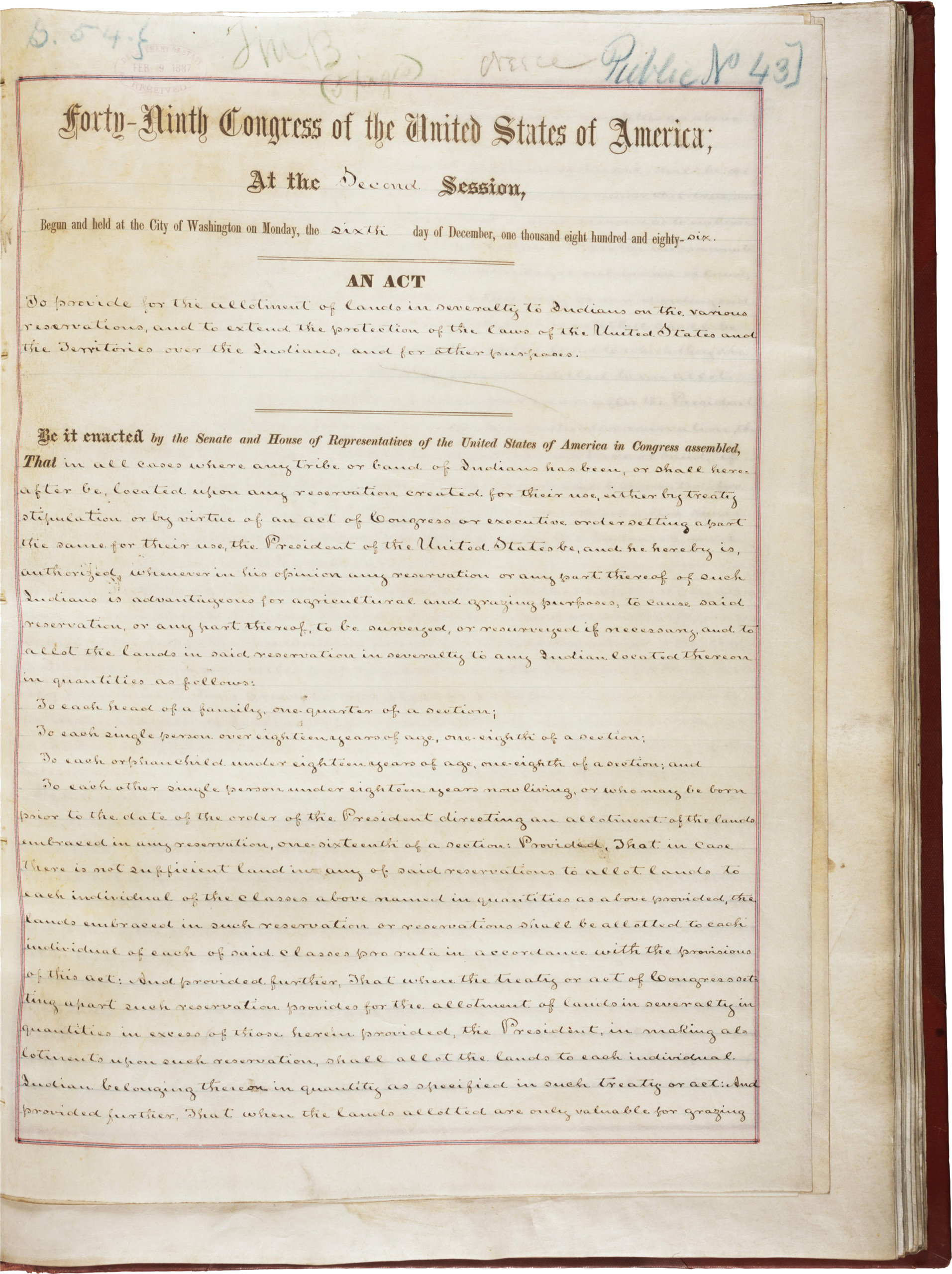
From Indian Territory's early inception, the United States government set it aside by congressional act as a place for tribes to live and govern themselves. So, the US had to approach the tribes in the Territory—in a way that they didn't have to approach tribes in the rest of the United States—to ask if they would be willing to voluntarily comply with allotment. The southeastern tribes were against allotment and especially against the dissolution of tribal government that was part of the process. The US federal policy idea behind this is that as tribal citizens accepted allotment certificates they eventually would become US citizens and have the same legal status as anybody else in the United States.
If you don't get anything else out of this talk, you can take away the "Native 101" fact that that tribal people, unlike any other minority group, ethnic group, or any other racial group, are defined differently from a legal standpoint in the United States. They constitute governmental entities that have the right to a government-to-government relationship with the United States federal government. With the passage of the Dawes Act, the United States was thinking maybe it could also work itself out of the Indian business, so to speak—which is to say work itself out of the unique status guaranteed to tribes. Sometimes people call this status a trust relationship, not because Indian tribes and the government particularly trust each other, but because of this unique legal standing that involves the right to self-government.
Congress found itself in a bind, having to ask the southeastern tribes, unlike other tribes in the US who weren't located in a special territory, if they'd allot land, if they'd give up tribal government. The tribes said no. Congress, being the entity that passes legislation in relationship to tribes, then flexed its muscles by expanding its plenary powers, the rights it has to pass regulations relevant to tribes, to the nth degree. It tried to make those powers as fulsome as possible by passing the Curtis Act of 1898 which forced the Indian Territory tribes to allot.
One of the things that's really striking about the Curtis Act, from the perspective of someone like me who's not a legal scholar, is that it legislates that the tribes can't have legal representation, can't contest the Act, can't rise to their own defense. With the tribes being forced to allot, the Curtis Act was an assault on tribal government, tribal land, and tribal culture.
After the Dawes Act was passed, then the Curtis Act in Indian Territory, of course tribes didn't disappear. They still organized themselves and formed political entities. After this, the federal government tended to recognize tribal governments on an ad hoc basis. There was a lot of inconsistency. From my perspective, it seemed to work this way: the Bureau of Indian Affairs says, "Okay, here's a tribe that's cooperative. Here's a tribe that opens up its reservation for exploitation of its resources to outsiders; that lets people come in and harvest timber, water, mineral resources, good tribal government, duly elected, we recognize this one." But then there's this other tribal government that's not so keen about letting people come in and take water, timber, and minerals. Then the BIA cries foul, claims this one as bad government they don't recognize, for any number of reasons they create. Since some tribal governments were recognized and others weren't, there was a growing web of confusion with no national template or cohesive policy.

In 1934, Franklin Roosevelt appointed John Collier to head the Bureau of Indian Affairs. Collier, a much more progressive leader than his predecessors, successfully lobbied Congress to pass the Indian Reorganization Act. This legislation, often called the "Indian New Deal," allowed tribes to form constitutions if they chose to do so, to submit them to the Bureau of Indian Affairs for approval, and, if they were approved, then they were allowed to form governments that the United States would recognize.
I'm going to leave it at that. The panel can correct my mistakes and I will not be offended. Sarah is going to describe how the status of the Creek Nation has changed since the July 9, 2020, McGirt Supreme Court ruling. Then we'll see what other panelists want to say.
Panel Discussion
Sarah Deer: Thank you, Craig, for that great introduction and thank you all for inviting me to be part of this panel. As a Creek citizen, this is a case that will have deep meaning for us for many years to come. And as a disclaimer, I'm here today in my personal and academic capacity. Because I also advise the Creek Nation, I want to clarify that I don't speak here in any official capacity, on behalf of the Nation.

I want to make sure as we discuss this case that you've got the basic facts. We're talking about two cases here, but the one that counts is McGirt v. Oklahoma, which was argued online due to COVID-19. We could all call in and hear the oral arguments—we're not used to that. Most of the time you have to go in person.
The decision was released in July on the very last day that decisions were announced. I think it's clear that this is one of Justice Ginsburg's final, if not the final, votes of her tenure on the Court. It's interesting that we focus on reservation law with this case, but actually both of the cases at issue here began as criminal cases. I'm glad that Professor Creel is on our panel because she'll have some more insight into the work of how criminal defense attorneys think about reservation issues.
But there were two cases. There was a case involving Patrick Murphy (Sharp v. Murphy), who was convicted of homicide and sentenced to death by the state of Oklahoma. And then the case's (McGirt v. Oklahoma) namesake here, Jimcy McGirt, a Seminole man who committed some heinous sexual crimes on children and received a draconian one thousand years in Oklahoma custody. So, these are two men that had very little to lose by appealing their decisions. When you're on death row, you've got attorneys who are trying any way to save their client's life. And from Mr. McGirt's standpoint, there was not a lot to lose by challenging jurisdiction. But both of these men, and even the state of Oklahoma would agree, committed their crimes within the boundaries of the 1866 reservation that Craig discussed.

From the perspective of a criminal defense, the fact is that if this is an Indian Reservation, if it still exists, then these two men were prosecuted by the wrong government. Under the Major Crimes Act, the federal government has criminal power over lands considered Indian Country and the state does not. So their argument on jurisdiction hinges on the question of whether or not the 1866 treaty is still the standard by which we assess Creek territorial jurisdiction. There were other cases that came before this, that did not have to do with the Creek Nation but answered a similar question: Is the reservation still there or not? Do the boundaries still apply or not? And the rules that the Court has created over the years require that Congress explicitly change the governing territory of the tribe. There were two other cases in the last thirty years in which the Court held that only Congress can establish a reservation and it cannot be inferred. It has to be explicit.
Attorneys for Murphy and McGirt argued that the defendants were prosecuted by the state of Oklahoma, which did not have jurisdiction over them. Now Craig did a great history here, so I don't need to go through all of this, but it was in 1866 that this treaty was signed. And really the language of the treaty that I think Justice Gorsuch focuses on in his written decision is the very clear language that this land—and again, there was half of it ceded in 1866—would be forever set apart as a home for the Creek Nation. And this is consistent with the other treaties that the Creek Nation had signed, even those prior to removal. So the language was consistent—words like "forever" and "perpetuity" are important for the contemporary interpretation.
What Justice Gorsuch did in McGirt was write the official decision on behalf of the majority. It was a five-four split. Writing for what people characterize as the liberal arm of the bench, Justice Gorsuch determined that because there had been no explicit language by Congress, despite allotment, despite demolishing tribal courts, despite all of those things which Oklahoma certainly argued, there was never a clear disestablishment of the reservation by Congress. Therefore, the 1866 reservation still exists. Therefore, McGirt and Murphy were prosecuted by the wrong government.
The Creek Nation and other amicus clients filed briefs in this case, and the ultimate outcome was one of victory—not just for these two criminal defendants, but for the Creek Nation and potentially many other nations. Justice Gorsuch writes that on the far end of the Trail of Tears was a promise, and "because Congress has not said otherwise, we hold the government to its word."
I want to share two more quotes from McGirt to emphasize how emotional this decision was for many of us. It felt like it set things right for the first time in a long time. One of the passages I so admire from this decision is that "Congress may sometimes wish an inconvenient reservation would simply disappear. But wishes don't make for laws." These kinds of principles transcend Indian law and speak to what justice really is about.
Justice Gorsuch also writes, "None of these moves by Oklahoma would be permitted in any other area of statutory interpretation and there is no reason why they should be permitted here. That would be the rule of the strong, not the rule of law." And finally: "Unlawful acts performed long enough and with sufficient vigor are never enough to amend the law. To hold otherwise would be to elevate the most brazen and longstanding injustices over the law, both rewarding wrong and failing those in the right."
Because today is Indigenous Peoples' Day, this particularly resonates with me. It isn't just about this Creek tribe and this Creek reservation. It's about a justice of the Supreme Court acknowledging the harms that were done and fighting for justice today.
So now we have a reservation. We always had one, but now it's recognized again. And what that means is that our territorial reach as a nation is far further than we have been exercising it. The Creek Nation now has full territorial reach throughout the boundaries of the 1866 reservation. Which is about a twelve to thirteen county area, including a great deal of the city of Tulsa. We are now tasked as a nation with governing that reservation and with the challenges posed by a large expansion of recognized territorial reach. But these are challenges that the Creek Nation is ready to take on.

Prior to McGirt, the Creek Nation had what we call Indian Country, a legal term of art referring to land that's been in trust or has a restricted status, owned in fee by the tribe—plots of land, whether they be former allotments or contemporary business district holdings. That was it. That was Indian Country. Once you step off that plot of land into the state of Oklahoma, then the state would no longer recognize you as being in Indian Country. But one of the definitions of Indian Country is all lands within the limits of any Indian reservation. So if the reservation still exists, our authority in terms of criminal law doesn't just rely on a particular plot of land; it's going to be anywhere within the boundaries of the reservation. This is a dramatic increase in recognized territorial authority.
Craig Womack: Professor Creel do you have anything you would like to add?
Barbara Creel: Yes, thank you for inviting me. Happy Indigenous Peoples' Day. Know that you are on Native land that was inhabited before contact, before the white settlers came. The McGirt case is one of the most important Supreme Court cases in land acknowledgement.
As far as background to McGirt, I wanted to add a couple of things. Professor Deer mentioned Sharp v. Murphy which started out in the Tenth Circuit as Murphy v. Royal and percolated up to the Supreme Court. It was argued and set for re-argument, but it was going to be a four-four split because Gorsuch had recused himself. You see, the decision was a Tenth Circuit decision from when he had been on that court. He didn't write that decision, but it wouldn't be proper for him to weigh in on it from his new position on the Supreme Court.
McGirt didn't change the status of the Creek Nation or expand tribal jurisdiction. McGirt recognized that the tribe had ancestral lands that were documented in treaties and congressional enactments. Federal criminal jurisdiction versus tribal jurisdiction versus state had been established in the 1883 case of Ex parte Crow Dog, which led to the Major Crimes Act of 1885. So, as Professor Deer said, if it was Indian Country and a murder after 1885, the case would be prosecuted in federal court.
Craig Womack: Along the lines of talking about ideas that came out of the 1883 case, I want to ask a question. And this very much comes from the perspective of someone whose head swims when hearing legal history. (Mainly I write novels and I play the fiddle.) But my question is this: since the McGirt decision recognizes Oklahoma tribes as having reservation status, does this ruling simply catch up Oklahoma tribes to the rest of Indian Country—much of which has had reservation status for a century now—or does it do something more?
Andrew Adams III: I guess I'll jump in quickly. First of all I thank Craig and Emory University and everyone that put this together. And I will give the same disclaimer that Professor Deer offered: I'm here speaking in my own personal, individual capacity. But to quickly answer your first question, Craig. I approach it from the standpoint that the status of the tribe didn't change, but the status of the law and essentially the federal government's posture and position related to the Muscogee Nation, changed.
The Muscogee Nation didn't change. But if you think about it in very practical terms, before the McGirt decision was issued, the Department of Interior didn't have to recognize or give any credence to the reservation boundaries. But after the Court issued its decision essentially reaffirming—and I say "reaffirming" because I don't like the terms "recognized" or "reestablished." Those reservation boundaries never went away. I can remember my first year of law school at the University of Tulsa in 2003 sitting in Professor Rice's office (whom I affectionately call Uncle Bill) and him saying, "Nephew, your tribe's reservation, you're sitting on it. You're living on it right now." I had always heard these stories about the reservation going away and he said don't believe any of that. "Congress is the only entity that can take away or diminish a reservation. And by golly nephew, when you moved down here from Michigan you moved onto your homeland."
And so when the decision was issued, it struck me emotionally. I already knew that Uncle Bill was one of the smartest people I'd ever met. But it just drove that belief further home that nearly twenty years ago, Uncle Bill—and not only Uncle Bill, but also one of the colleagues that I have on the Supreme Court, Justice Leah Harjo-Ware, when she was the attorney general for the Muscogee nation years ago—that nearly twenty years ago he made those same arguments.
There are a lot of Muscogee people who have walked with that belief close to their hearts and minds.
Then to answer your second question, Craig, the existence and disputes and concerns about reservation boundaries permeate across Indian Country. There are a number of tribes that either are in some type of dispute with, say, a county sheriff over who has jurisdiction over what people over what geographical area, or they could be in federal district court, or in some type of court of appeals where they're trying to press their case as to why the boundaries that are identified by the federal government or a state government or some subdivision of a state government are not correct.
I believe that what McGirt has done for Indian Country is to reaffirm all of those decisions in the past like Solem v. Bartlett and Hagen v. Utah where Congress is the only entity that can diminish or disestablish a reservation. And you actually see just in the time since McGirt was decided, a positive cascading effect on other federal courts, where they have provided some favorable decisions for tribes. As an Indian law practitioner and someone who, when I wake up in the morning, kind of feels like Luke Skywalker—that I fight for the good guys, that I represent tribes—I hope that continues. I hope that various levels of government get to the point where they do have that respect for tribal homelands.
Craig Womack: Thank you, Andrew. Do other panelists want to join in this discussion about reservations status?
Sarah Deer: There's been a lot of backlash from both state officials and the general public in Oklahoma, whom I don't think fully understand what McGirt means. No, it does not mean that five tribes own the east half of Oklahoma as it's somehow been suggested. Nothing changes the status of the land within the reservation. If you own a home in Tulsa or Glenn Pool, nobody's going to take that home away from you. If you're a private business and you have your business on the reservation, the status of the land where you run your business does not change. What it changes, though, is the extent to which the tribe's sovereignty is matched in the territory that it exercises; the Creek Nation has more options for exerting governmental power now. But in no way does it does it take somebody's land away or take their livelihood away. And I think that's been misrepresented in the press quite a bit.
Craig Womack: A lot of what we have heard and read about has focused on the tribe having increased jurisdiction over criminal cases. It's being depicted as an advantage. But we have also heard about the tribe now having more cases to take care of than ever before, and some have said, the situation may be overwhelming to the extent that there may be a need for expansion of the tribal court system. I was thinking when I listened to Professor Creel's podcast, which is really excellent, about her insights into the Major Crimes Act and how this act is still imbued with a colonial viewpoint. So are there other advantages, or any disadvantages, to be considered?
Sarah Deer: I'm going to let Professor Creel answer the crux of that, but yes, again, a lot of people don't realize that, technically, tribes retain concurrent authority over felonies on reservations. That's misunderstood when people read the Major Crimes Act as though it was a grant of exclusive jurisdiction to the federal government. Tribes in some states, not all, prosecute homicide, rape, and child sexual abuse, but by and large, when we think about those kinds of crimes on reservations, we think about them "going federal"—so the US attorney's office becomes involved. But certainly the tribe can also independently exercise that kind of criminal authority. To the extent that one would calibrate justice for victims with more tribal prosecution, the tribe is now in a position to do that on a much grander scale. But it does require additional staffing to be able to govern that big of a stretch of reservation. In terms of the criminal defense perspective, I'd like to ask Dr. Creel.

Barbara Creel: Thank you, Professor Deer. I would like to hear from the tribe about advantages and disadvantages, but I know from my criminal law teaching that sovereignty is what sovereignty does. As a sovereign, the tribes have incredible power to shape their own justice systems. I teach the differences between the American cultural and moral values and Indigenous cultural values and rely heavily on Sarah Deer and Carrie Garrow's book, Tribal Criminal Law and Procedure, in which they discuss where tribes get their inherent decision making about what wrongdoing is and how to punish it. How do sovereigns address wrongdoing in their own jurisdiction? It's powerful to think about. We could start over, right? We could be a Crow Dog nation that looks to restorative and rehabilitative justice instead of retribution.
We all know that the first thing we hear on Indigenous Peoples' Day is the parade of horrible statistics that Native Americans are subjected to. This case provides opportunity for the defendant who was a community member and the tribe to be on the same side. That does not happen in Indian Country cases. It's usually the United States acts as a punisher and the tribe acts as a punisher. But at this point, the two interests converge between the individual defendant and the tribe. I think it promotes what I teach: tribes are made up of individuals. What I was taught from my family values is that the people are the heart of the tribe. The tribe is the body and the people are the heart.
The advantage is having tribal sovereign government rethink its criminal jurisdiction and do differently than what the adversary system has imposed upon us. The disadvantages in this line of thinking are what Professor Deer mentioned: we're so far behind in resources in our own justice systems because they were taken away or encroached upon due to the Major Crimes Act.
We are impoverished in the ability to think and rethink about justice. I've taught tribes how to look into their own history to decide how to move forward. This was a foreign concept, either because the state took over after termination or because of the Major Crimes Act. But because of this rule of history that Gorsuch mentions—this is always the way we've done it, so we're going to keep doing it that way—tribes have lost their own thread of thought in how to treat wrongdoing. They've been without resources and basic governmental functions.
Andrew Adams III: When you think about federal policy related to Indian tribes over the last two hundred years, it's gone through different themes. Since the Indian Self Determination and Educational Assistance Act, the federal government has been in this mindset of self-determination—that tribes should be self-determining in expanding their sovereignty. So the biggest advantage that I see from McGirt is that the decision opens up a lot of options for the Muscogee Nation to expand and mature its jurisprudence. It expands the different types of cases that can come before the Muscogee Nation courts. I believe that the volume will increase and with that more opportunities for the courts of the nation to issue decisions that further the maturation of Muscogee case law.
Craig Womack: Thank you, Andrew. I want to ask one more question of Sarah, and of course anyone else can weigh in on this. Since McGirt has to do with tribal jurisdiction and sexual violence, can you address these two topics in relation to one another?
Sarah Deer: Certainly. What's interesting about this case is that I worked with a Cherokee attorney named Mary Kathryn Nagle, and we've been filing amicus briefs in Indian law cases for the last five or six years. We feel like the voices from Indian Country of victims of crime are not often presented to the Court. We did that in McGirt and in Murphy. Our primary client was the National Indigenous Women's Resource Center, a large national Native nonprofit that's dedicated to ending violence against Native women and children. We argued on behalf of McGirt and on the side of the tribe that these cases belong in tribal court. To the extent that we have strange bedfellows, I think it's worth noting again that this idea of sovereignty matters for victims and sovereignty matters for defendants. Tribal nations are in the best position to make decisions about how to protect people and hold people accountable. It may seem ironic that a victims' rights organization would side with somebody alleged to do some pretty horrific things, but the end goal of making sure that tribal nations are strong and capable of protecting one another is at the core of what any sovereignty battle is about—the battle to define what's right and wrong and how we resolve those questions.
Barbara Creel: That's Indian law, right? We're a unique, interesting, quirky, crazy quilt of jurisdiction. I wanted to add another point with regard to disadvantages. Tribes have the power to adjudicate criminal acts on the reservation. Because of separate sovereignty and the dual sovereignty doctrine, a Native American can be facing up to a year in jail without the benefit of counsel. Natives are the only people that that happens to in the United States. We're the only ones that can go to jail without an attorney. Natives are also subject to double jeopardy because they can be prosecuted by their own tribes and by federal court under the Major Crimes Act. The problem of over-policing and over-criminalizing and over-incarcerating Native Americans has a long legacy. In footnote six of the McGirt decision, the Court says some helpful things about land recognition and Native rights and points to the Pueblo Indians in the case of United States v. Sandoval. But that 1913 case was one in which the Supreme Court was trying to decide who was an Indian, and whether Pueblo Indians were Indian because there was no definition. What did the Court look to determine whether Natives were Indians? Behaviors and stereotypes. They decided that Pueblo Indians were dimwitted, had plural marriages, practiced non-Christian religions, and were in need of guardianship. That's the legacy that continues to thread into these 2020 cases. We're still carrying around those labels.
Craig Womack: Thank you. We're going to move to questions with the help of Dr. Megan O'Neil, assistant professor of art history at Emory University and faculty curator of the Art of the Americas at the Michael C. Carlos Museum.
Question and Answer Session

Megan O'Neil: Thank you, Craig. The audience has posted many questions, which I think speaks to how important this work is.
First I want to read a comment from an attendee, Stuart Fenton: "The language used by Justice Gorsuch was beautiful, brings tears to my eyes, even though I'm not Native. I'm a lawyer, however, and Jewish so I understand deeply the wrongs done to your people; similar wrongs have been done to mine."
How about the more general question about the implications of this decision in Indian Country outside of the Creek Nation?
Sarah Deer: I think the way in which Gorsuch challenges the other justices to confront the ugly history of federal Indian law and to look at what really happened on the ground could have impact on cases involving tribes that have related concerns about questions of self-government. His ability to look and be honest about the history is, I hope, a template for justices ruling on Indian Country cases in other contexts.
Megan O'Neil: Here's a question regarding what's written in the McGirt majority opinion, that there is no reason why Congress cannot reserve land for tribes in much the same way, allowing them to continue to exercise governmental functions over land even if they no longer own it commonly. How would such a conclusion affect the outcome of Alaska v. Native Village of Venetie Tribal Government, et al. from 1998?"
Sarah Deer: Venetie is a devastating case out of Alaska. It actually came out when I was a law student. It made me wonder why I was in law school, it was so poorly reasoned. But it's a question of tribal territory, really a different animal, because it's looking at the Alaska Native Claim Settlement Act, which is not applicable in the lower forty-eight and certainly not in Oklahoma. So, I would love to see Venetie reconsidered, but I'm not sure McGirt really changes anything as far as that decision goes.
Barbara Creel: I agree. Venetie was looking at the definition of Indian Country and deciding whether the Alaskan Native corporations fit within one of those definitions and found that they did not.
Megan O'Neil: Here's a question from Sarah Hill asking if you could comment on the response to the decision by the Cherokee Nation and the state of Oklahoma.
Sarah Deer: Well, the state of Oklahoma is pretty unhappy, and that's been expressed by a number of state officials, including the attorney general, who referred to us as "sovereignty hobbyists" in one of his disparaging comments about our efforts to expand tribal authority. I can't speak to the Cherokee's official position or not. Each tribe is unique and different.
Megan O'Neil: This next question is for Justice Adams, from Veronica Passfield: "After attending graduate school with Andrew I moved to Oklahoma City. Governor Stitt created a committee to strategize about how to adapt to McGirt. His committee included oil and gas CEOs, but no tribal leaders. I'd like to hear thoughts on McGirt backlash and how the community can advocate to help offset it."
Andrew Adams III: It's appropriate that we're having this conversation on Indigenous Peoples' Day. The parade of horribles you hear from individuals, from the state attorney general and Senator Inhofe, claims that the Supreme Court is creating an untenable situation in Oklahoma where the Muscogee Nation is going to be able to exercise "enhanced jurisdiction" or "extra jurisdiction" over its reservation. People say that the sky is going to fall if you give these Indians authority over their land again.
A lot of people, when they think about reservations and about treaties, think about the United States saying, "Okay, we're going to give you this land." But there's another way of thinking—and there's power in words—that reservations are the land that the tribes reserved for themselves. It wasn't anything that was given to the Muscogee Nation. This was land that the Muscogee Nation saved for itself as a homeland in exchange for other rights. Anyone who predicts the sky is going to fall, they are perpetuating the settler mentality imposed upon Indian peoples. The US Supreme Court did the right thing by issuing this decision. And now let the state of Oklahoma and the Muscogee Nation work as sovereigns.
Megan O'Neil: This next question is from Sarah Armstrong, a current public defender in Atlanta, a University of New Mexico alum, and a former student of Professor Creel. "What advice can you give to non-Native defenders of Indigenous rights, especially with respect to this decision?"
Barbara Creel: Every time I work with a person from a different family, a different community, a different tribe, a different government, I treat that experience as one of an ambassador. Learning about the particular tribe. I teach the way to be an ally is to promote Indigenous wisdom and Indigenous voices. Learn about the ancestral lands which you are standing on right now and elevate the voices of Native people. Educate yourself but know that each tribe is different. There is no pan-Indian way. Combat willful ignorance. Don't give up because these issues are complicated. Be willing to fight those injustices where you see them.
I appreciate the work of the Indigenous Women's Network and of all those who come to these issues with their own wisdom and with the experiences of having lived through violence or the criminal justice system or being court-involved.
Megan O'Neil: The next question is for Professor Deer, regarding sexual violence law jurisdiction in Indian Country: "How do you hope the case against McGirt and other cases of sexual violence committed in this region will be pursued? How does the Violence Against Women Act come into play, and how might the Creek and other Native nations bring Indigenous perspectives to such cases?"
Sarah Deer: Thank you for the question. Yes, Mr. Murphy and Mr. McGirt have both been indicted in federal court, which was the appropriate court that should have had their case from the beginning. While some headlines suggested that McGirt is leading to the release of dangerous persons, the reality is that McGirt and Murphy are still under the jurisdiction of the United States and are going to either plea or be prosecuted by the US attorney. So as far as they're concerned, the question might be, "Could the tribe also prosecute them under concurrent authority?" Certainly, going forward, the Creek Nation has a homicide law. It has a rape law. It has a child sexual abuse law, a child pornography law. So, the Tribal Council, the legislative branch of the tribe, has passed laws which suggest that the government would like to see authority in those cases. Only time will tell. I do think that the tribe has the potential at this point to take other kinds of crimes under tribal law. That'll be an interesting development, and as Professor Creel noted, we're not necessarily wedded to the Western law-and-order model. We can create therapeutic models of justice. Many tribes have done that. It's a very interesting time to be Creek.
Megan O'Neil: "The Supreme Court has not ruled on whether the Major Crimes Act divested tribes of jurisdiction, but it's widely accepted now that it did not. However, there's contrary language in some Supreme Court decisions. As I read the Gorsuch opinion, it doesn't have any definitive language suggesting he views the Major Crimes Act as divesting tribes of power, but there's some language that could be read as suggesting he assumes it did. Can you say anything about whether or how the opinion might affect tribal jurisdiction over major crimes or how the tribe might be approaching the question?"
Barbara Creel: That sounds like Professor Rolnick.
Sarah Deer: Thanks, Professor Rolnick, I'm sure we can write a law review article on this question at some point. I think any reference to whether the tribes retain jurisdiction or not in Gorsuch's opinion is a matter of dicta. Of course, you know, I think the reasoning that only Congress can divest tribes of jurisdiction would apply here. That the Major Crimes Act did not divest—there's no explicit language in the Major Crimes Act divesting tribes of jurisdiction. But yes, you're right. The question is not definitively answered in the Supreme Court at this time, but I feel confident that using this kind of case as a precedent will aid that if it does come before the Court at some point.
Barbara Creel: I read the opinion, too, with Gorsuch saying that the Major Crimes Act encroached upon tribal jurisdiction, but it was a limited encroachment in that it was specific enumerated crimes. It's widely accepted that there's concurrent jurisdiction because of Supreme Court decisions that say the dual sovereignty doctrine applies. I think that there have been implications that both the tribe and the feds have jurisdiction.

Megan O'Neil: Here's a general question about Muscogee Creek language: "As someone who was born and raised in Bogotá, Colombia, currently living in Massachusetts, I advocate for linguistic human rights being a native Spanish speaker. And I'm wondering if any of the scholars in the panel know about laws regarding language access or language advocacy, not just for the Muscogee language or the Creek people, but any of the hundreds of Indigenous languages in the United States."
Craig Womack: I'm not sure I can answer this question. For a long time, Sarah and I were in a group that got together to speak Creek with our mentor Rosemary McCombs. One of the things that Sarah was always interrogating was whether or not there are certain Muscogee words or ideas that had to do with legal principles. So, Sarah, did you want to say something about this? You can answer it better than I can.
Sarah Deer: I have to admit, that while I am a language learner, I don't know much about any federal or governmental policies about promoting language per se. I tend to focus my scholarship in the criminal arena, but there are people actively trying to save the Creek language today. It is an endangered language. We do have a linguist that committed himself to our language. His name is Jack Martin at the College of William and Mary. He co-authored our dictionary and grammar book. It is always an ongoing process to save an Indigenous language and our tribe does have a language department and there are a couple of colleges in Oklahoma that teach Muscogee language. But beyond that, I don't know that I have a lot of knowledge to bestow.
Craig Womack: I don't know of any state that has recognized a Native language as an official language.
Barbara Creel: New Mexico's constitution guarantees access to the courts in additional languages besides English. That means Spanish and Native languages. Because of the Major Crimes Act, Native language certifications are really important. States with large Native populations or states that care about Native citizens can pass a statute with regard to language access in the court system simply on a due process basis. The Pueblos come at it from a little bit different viewpoint in that my tribe has language immersion at Head Start. Language is spoken in the home and in intergenerational daycare. There's also a lawsuit in New Mexico suing the state department of education for lack of language access and services for Navajo and Pueblo speakers.

Andrew Adams III: I'll just quickly add that there are tribes all across the country that have passed tribal laws concerning traditional and Indigenous intellectual property protections. Often, tribes will identify their language as being part of that corpus of information that they consider that needs to be protected and archived and will actively budget funds for that protection, not looking to the state or the feds.
Barbara Creel: In my tribe, there is a rule against sharing the language because Pueblo language is not for public consumption. You don't find it taught in community colleges as you do in other tribes. It exists for internal purposes and is imbued with concepts that shouldn't be shared with others. The tribal language provides a different function than English does.
Megan O'Neil: Thank you so much. Here's a question from Ed Barker who's asking if McGirt affirms Congress's power to extinguish Indian Country. What do you all think about that question?
Andrew Adams III: From my standpoint, McGirt does essentially prop up the legal concept, the plenary power over tribes, right? That Congress, if it wants to, can pass statutes that dramatically change the legal relationship between the United States and federally recognized Indian tribes. And in this current environment, in some respects I don't mind that.
Sarah Deer: I agree, and I think that's been a big critique, especially by scholars who raise the question, "Is this really a victory if it continues to recognize Congress's plenary power?" In response to that, I'm not sure we will ever have that victory in the Supreme Court. What's important to note about this question is that tribal interests have had a much better go of things working with Congress than working with the courts. We tend to lose in the federal courts quite a bit, but yet we've managed to sustain some pretty progressive legislation in Congress. So if Congress is the place to go, I feel like the political process offers more ways to pursue tribal interests. We don't have control over the litigation that comes up about our sovereignty within the federal courts. But I don't think at this day and age, you would see a complete repudiation of Congress's plenary power, but one can always hope, I suppose.
Sarah Deer: I've written on tribal law, but primarily on violence against Native women. And because I get asked a lot, I finally made a website where you can find my writings at SarahDeer.com.
Barbara Creel: I'll also recommend the Sarah Deer, Carrie Garrow book that I mentioned before, Tribal Criminal Law, as a ready resource for people that just want to understand criminal jurisdiction in Indian Country with really good examples of Native thought in criminal law.
Conclusion
Craig Womack: This has been an amazing discussion. Not only for those of us on the panel, but for the impressive level of experience of the audience—people who went to law school with, or are former students of a panelist, academics such as Sarah Hill, who've written about southeastern people, grassroots people doing work in Creek country, law students across the country, law professors. And all the other members of the audience who have listened in. I'm excited too about the potential, as Professor Creel said, of being able to do things differently and maybe to expand into more ways of looking at restorative justice and creative approaches to governments and alternatives to punitive-based approaches to criminal justice. It's exciting to think about where this might lead us. Cehecvres, see you all again.
About the Panelists
Andrew Adams III is a citizen of the Muscogee (Creek) Nation and member of the Tvlahasse Wvkokaye Ceremonial Grounds. He currently serves as Justice of the Muscogee (Creek) Nation Supreme Court, Chief Justice on the Santee Sioux Nation of Nebraska Supreme Court, and Justice on the Gun Lake Tribal Supreme Court.
Barbara Creel, a member of the Pueblo of Jemez, is a professor of law at the University of New Mexico School of Law and former director of the Southwest Indian Law Clinic.
Sarah Deer is a citizen of the Muscogee (Creek) Nation of Oklahoma and University Distinguished Professor at the University of Kansas. She holds a joint appointment in the Department of Women's, Gender, and Sexuality Studies and the School of Public Affairs and Administration. Professor Deer is also the Chief Justice for the Prairie Island Indian Community Court of Appeals.
Craig Womack is an Oklahoma Creek-Cherokee Native American literary scholar, writer, and teacher, and an associate professor of English at Emory University.
]]>Video and Essay
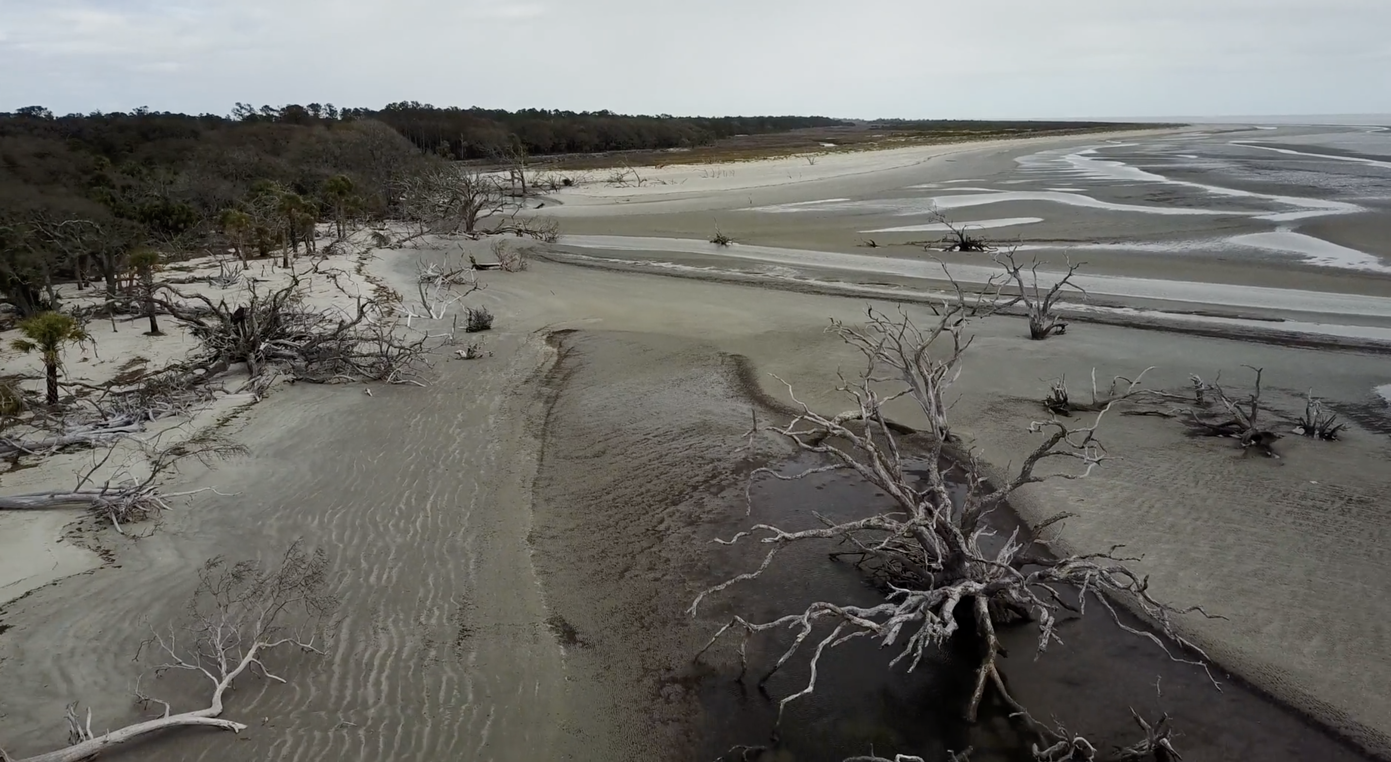
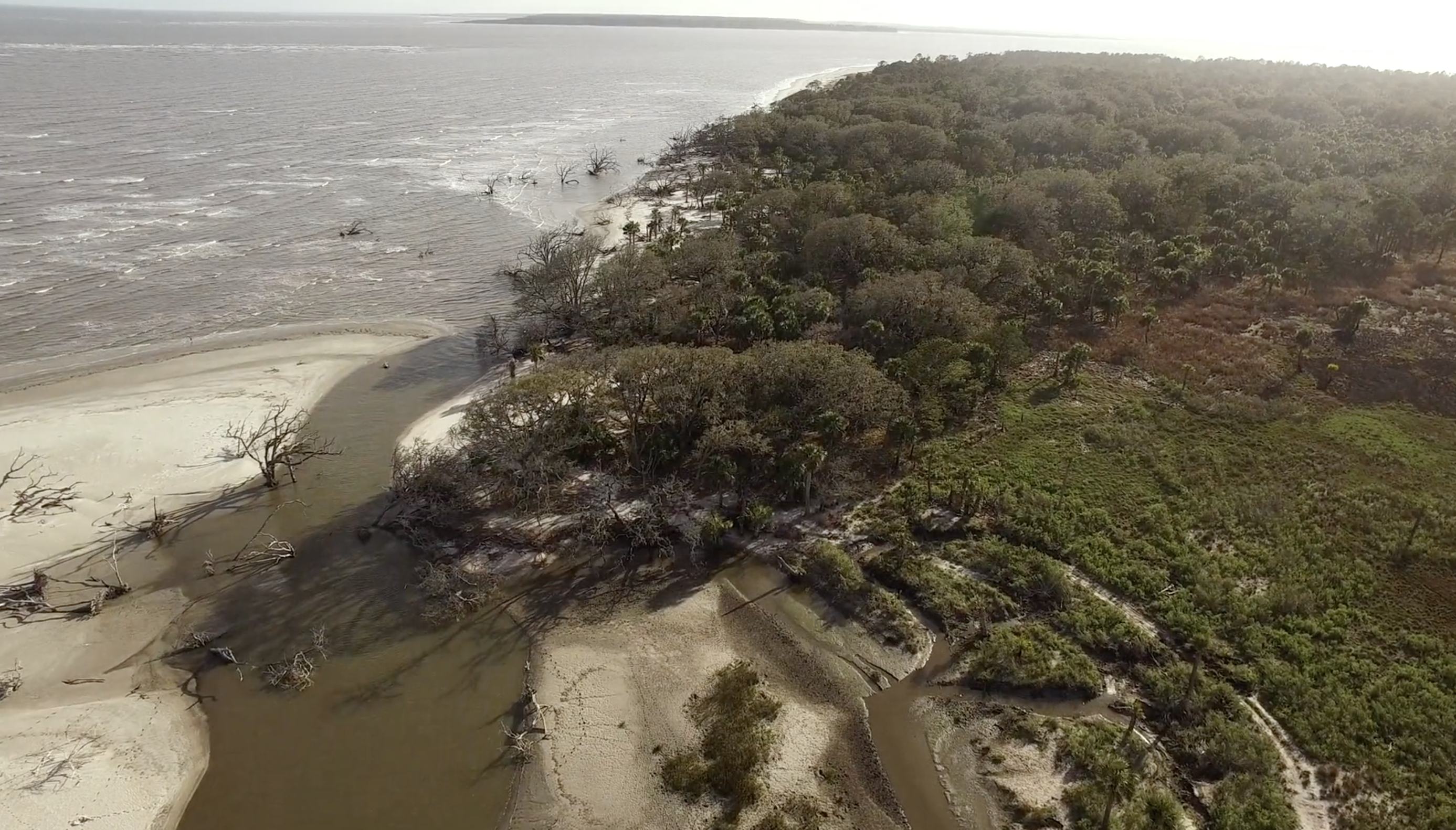
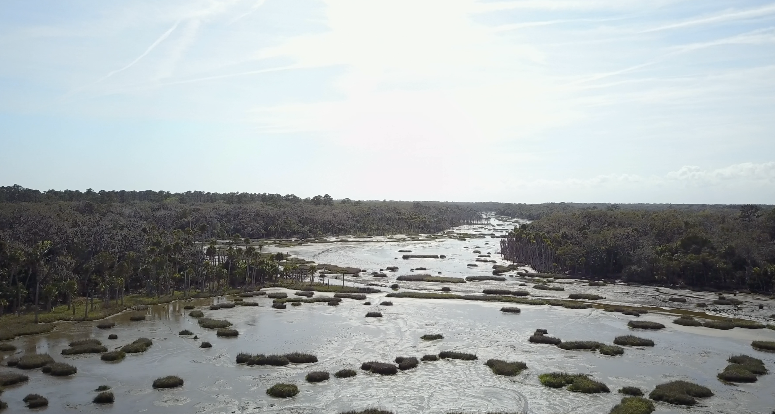
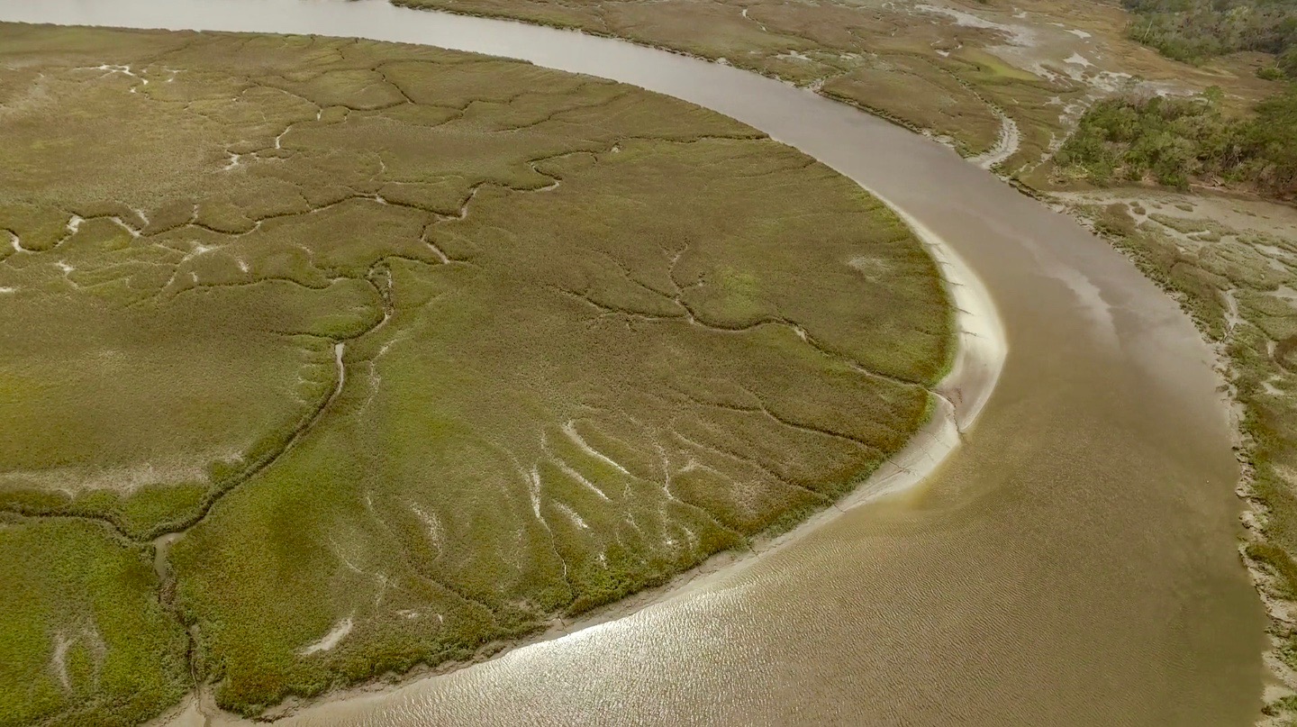
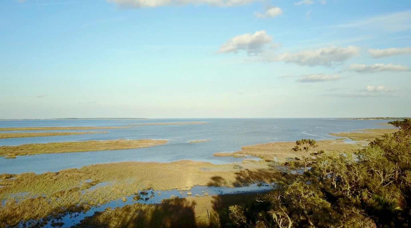
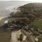
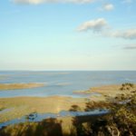
Ossabaw Island is a barrier island on the Georgia coast. The island, which trends northeast–southwest, is about 14.5 kilometers (9 miles) long and 10.5 kilometers (6.6 miles) wide. It is located between latitudes 31° 49.5' and 31° 43.2' N. Of the Georgia barrier islands, Ossabaw is the most geologically unusual. Like the major Georgia islands south of it—Cumberland, Jekyll, St. Simons, Sapelo, and St. Catherines—Ossabaw is a composite island, in which sediments from Pleistocene and Holocene shorelines are directly adjacent or superimposed. However, sediments of the Pleistocene (Silver Bluff) and Holocene shorelines on Ossabaw split near its southern portion, with the Pleistocene trending north–south and the Holocene trending northeast–southwest. The modern shoreline, which formed only in the past few thousand years, wraps around the southern and northeastern corners of the island.
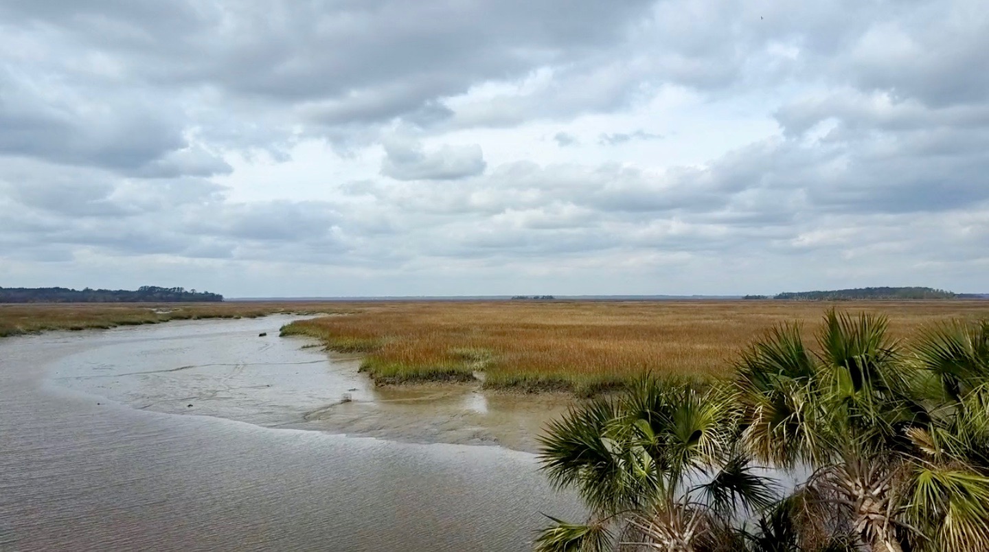
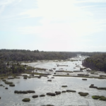
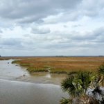
Ecosystems on Ossabaw include salt marshes, maritime forests, beaches, and a few freshwater ponds. Salt marshes are widespread west of Ossabaw, but also occupy much of the middle and eastern parts of the island between sediments of the Pleistocene and Holocene shorelines, dividing its maritime forests. The climate of Ossabaw is temperate to subtropical, with temperatures ranging from an average high of 32° C (90° F) in the summer to 10° C (50° F) in the winter. Average rainfall is about 50 centimeters (20 inches) per year, with most precipitation during the hurricane season (May–September). Hurricanes have rarely affected the Georgia barrier islands until recently, when Ossabaw was hit by Hurricane Matthew (2016), then later Hurricane Irma (2017). Hurricane Matthew, in particular, uprooted many of the older live oaks on the island and otherwise dramatically altered its landscape.
Although Ossabaw is often labeled as "pristine," humans have transformed its landscapes for at least 4,000 years. Its human history is similar to that of its island neighbor, St. Catherines, beginning with Native Americans (the Guale). The Guale had occupied Ossabaw since about 2000 BCE, but European colonization began when the Spanish arrived in the late sixteenth century. A lasting remnant of Spanish colonization on Ossabaw is the presence of feral hogs, some of which are linked to Spanish stock. This relatively large population of hogs has disrupted or otherwise altered ecosystems throughout the island.
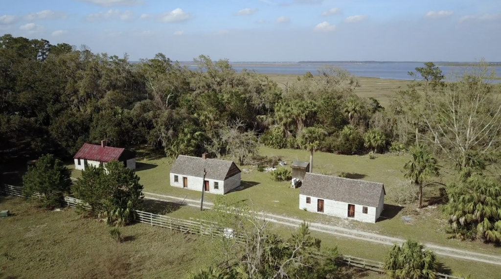
The British took control of Ossabaw in the 1730s, by which time the Guale had mostly moved inland or suffered near extinction under the pressure of colonization. Early treaties reserved Ossabaw as hunting and fishing ground for the Creek people until 1758. The British also began enslaving African people for their plantation economy, and in the late eighteenth century American settlers continued using enslaved people as laborers for growing cotton and indigo. Most inland ecosystems of Ossabaw, especially the maritime forests and salt marshes, were altered considerably by this agriculture. Following the American Civil War, a significant population of African Americans stayed on the island, but most moved to the mainland after the Sea Island Hurricane of 1893. Many of their descendants today comprise the Gullah-Geechee community in Pin Point, Georgia.
Through the early to late twentieth century, Ossabaw's ownership changed several times, but the island remained largely undeveloped and sparsely inhabited. The last private owners were members of the Torrey family, starting with Dr. Henry Norton Torrey and Nell Ford Torrey, and ending with their daughter, Eleanor Torrey ("Sandy") West. The Torreys oversaw the building of a large home for themselves, as well as hunting lodges, a beach house, and unpaved roads. In 1961, after Sandy West inherited the island, she and her husband Clifford West began the Ossabaw Island Project. This project brought luminaries of the arts and sciences to the island as a retreat center for study and discussion; notable participants included composer Aaron Copeland, writers Ralph Ellison, Margaret Atwood, and Annie Dillard, as well as ecologist Eugene Odum. This creative initiative also resulted in the Genesis Project, which focused more on the natural sciences and hosted scientists for on-site studies of and education about the archaeology, ecology, and geology of the island.


In 1978, Sandy West sold Ossabaw to the state of Georgia to establish it as the state's first heritage preserve, and it has been managed since by the Georgia Department of Natural Resources (DNR). The Ossabaw Island Foundation was established afterwards as a non-profit organization working with DNR to encourage educational, cultural, and scientific programs on the island. Sandy West continued living on the island until just recently; at the time of this writing (January 2020), she was living in nearby Savannah, Georgia, and had just celebrated her 107th birthday.
This Ossabaw flyover video provides a visual sample of the many interconnections between natural and human histories on Ossabaw. Featuring sweeping aerial views and audio annotations explaining the island's varied environmental features, this video is organized around four sequential but overlapping themes: fauna, flora, landscapes, and human structures.
Acknowledgment
Thanks to the Ossabaw Island Foundation for their support on this piece.
About the Authors
Anthony "Tony" Martin is a professor of practice in the Department of Environmental Sciences at Emory University. His publications include Life Traces of the Georgia Coast (Bloomington: Indiana University Press, 2013).
Steve Bransford is the senior video producer at the Emory Center for Digital Scholarship. His documentary feature film The Well-Placed Weed is available on the PBS website and app.
Michael Page is lecturer in Geospatial Sciences and Technology at Emory University.
Leotie Hakkila is an MPH student at the Rollins School of Public Health, Emory University.
Anandi S. Knuppel is a visiting assistant professor in the Department of Religious Studies at Lawrence University.
]]>Video
A Reflection by Craig Womack
A friend of mine tells a story about his high school days in the greater tri-city area (Wetumka, Weleetka, and Wewoka—Creek names for water that roars, runs, and barks—for those of you from parts other than rural eastern Oklahoma). One day in his Weleetka High School class, everyone stopped paying attention to the teacher and turned their eyes from the chalkboard, and United States history, to a Kafkaesque-sized cockroach making his (or her) way leisurely across the classroom floor, giant antennae twitching as it navigated its escape from secondary education.
As all of those in our noble profession know, even the most starry-eyed believer in the power of education sometimes loses control of the classroom, and this particular teacher, upon realizing her lecture had been hijacked by a very large insect, walked over to the uninvited intruder and ground it under the heel of her shoe. Given the size of the cockroach, some cleanup was in order, so she went down the hall to get paper towels from the restroom. On the way back, she heard all kinds of cheering coming from her class. While she had been out, the cockroach had reanimated and was making a second beeline, so to speak, for the door. If not for her puzzlement over all the commotion, the teacher might have nailed it again, but the cockroach reached safety, while all the Indian kids in the class cheered it on!
I don't care to judge the historical veracity of this wonderful tale, but it seems to me the Mvskoke Creek language might have about as much chance for survival as that cockroach, and I will leave it up to the reader, and the film viewer, to interpret whether or not I am suggesting that a miracle is needed or that miracles sometimes occur.1The official name of the tribe located in present-day Oklahoma is the Muscogee Creek Nation. The word, in the language, for what Creek people speak is "Mvskoke," pronounced the same as the word for the tribe. Some Creeks prefer the name "Mvskoke" since "Creek" is a name given to the tribe by the English in the Colonial era.

For sure, the dominating force of English surrounds us. People in Creek country say there are five thousand Creek speakers left, but nobody seems to know where that number comes from, and many suggest there are only a few hundred speakers, some even far fewer. This documentary, Hearing the Call: The Cultural and Spiritual Journey of Rosemary McCombs Maxey, features a Creek community leader who is determined to speak the Creek language every day—to people, when possible, and to llamas, chickens, cats, and dogs, when not.
Four years ago, I was approached by Stefanie Pierce, at that time the administrative assistant in the Department of Environmental Sciences at Emory University, who said she was talking to people about making a documentary on Rosemary. The project immediately struck me as having merit, because women in the Creek Nation are seldom given public recognition for their knowledge and contributions, especially in the realm of language and culture where women have been both instrumental as well as often ignored. In Rosemary's case, as Hearing the Call attests, she possesses multi-generational knowledge about community genealogies predating Creek Removal from ancestral homelands in Alabama and Georgia in 1836 as well as a command of specific family histories in Oklahoma Creek churches that goes back to the 1840s, when her family first started becoming leaders in these places of worship. Add to this her history working in Indian Country outside the Creek Nation, among Lakota people in South Dakota, for example; as an advocate for Native Hawaiian prisoners incarcerated in Oklahoma and Arizona; as an interim pastor for a year at Community of Hope, Tulsa's GLBTQ church; as a pastor of various United Church of Christ congregations on the East Coast; and as a person in critical dialogue with leading feminist, race, and theological scholars in the 1970s and 1980s, and it becomes evident that the subject of our documentary has more stories than we could ever put up on the screen.

As I, along with Rosemary herself and a group of Creek language advocates, watched the story unfold when Hearing the Call premiered at Emory earlier this year, it felt like its own kind of coming out story, albeit in this case the story of a kid who, rather than announce to her parents she is gay, instead tells them she's called to be a preacher—even though no such role exists for women in the denomination she grew up in. What strikes me as an incredible act of the imagination seems like something else the way Rosemary tells it: being around preachers was the only thing she knew, so as far back as she can remember she practiced sermonizing on farm animals. I don't know if Rosemary would have ground the cockroach into oblivion, had it shown up during one of her childhood church services on back porches and in farm wagons, but, having known her for many years, I feel confident that it wouldn't have escaped without being addressed at length in the Creek language, and I don't hesitate to imagine it coming up to the altar to be saved.
What is the Creek language, anyway? Without getting too complicated, let's just say it is one of the original languages of the US Southeast, and since I am an Emory professor, I will add that it is the first and foremost language of the campus where I teach. Creek people lived at Emory's exact location prior to the 1820s, having been forced out of the area earlier before the removal of the main body of the tribe that occurred in 1836, the year of Emory's founding. When I am on campus, therefore, I simply have to look where I am stepping if I want to know where the Creek language originates.
The language was originally spoken throughout Alabama and Georgia, and in the late 1700s and into the early decades of the nineteenth century, it spread into Florida through Creek-speaking groups that migrated there and now live on the Seminole reservations and elsewhere in Florida. In 1836 when the tribe was forcibly removed from Alabama and Georgia to the present-day state of Oklahoma, the language moved into what was then known as Indian Territory, a sovereign entity set aside for the exiled tribes sent there. Today, the language is primarily spoken by Oklahoma Creeks, Oklahoma Seminoles, and Florida Seminoles.


The first university course in the Creek language took place at the University of Oklahoma in the fall of 1991. As fate would have it, I was in that course. A non-Indian graduate student in anthropology, Pam Innes, was the instructor of record, and she was working with the Creek ceremonialist Linda Alexander and her daughter, Bertha Tilkens, both active members of Greenleaf Ceremonial Ground. I remember three things very vividly from that first effort. First, a Creek/Comanche friend of mine, who sat next to me, would rail after every meeting: "How can we have this non-Indian, who doesn't speak the language, trying to teach us how to speak Creek?" I didn't feel inclined to disagree. Secondly, there was constant writing and erasing, the instructors' hands working at cross-purposes, as Pam would write down a verb she had Linda conjugate, then leave it on the board; the next time Linda conjugated the verb it would be totally different, due to the infinite contextual factors that change Creek verbs. Thirdly, though we had no cockroaches for entertainment, Linda had her own way of hijacking a classroom through hilarious and raunchy stories that I have never quite gotten over and hope I never will. I am happy to report that the collaboration between Pam, Linda, and Bertha evolved into a respectful and reciprocal alliance, a friendship I have always been grateful to have been caught up in.
Since these tenuous beginnings, when academics were speculating about how Creek language worked, often relying on the meticulous fieldwork of the linguist Mary Haas, who worked in Oklahoma in the 1930s, and basing their guesses on Mary Haas's guesses, the Creek language has come a long way in terms of formal analysis. A significant part of the progress has involved checking and analyzing this earlier linguistic work with a large cohort of contemporary Creek speakers.
.")
Pam Innes's collaboration produced a Creek grammar—Beginning Creek: Mvskoke Emponvkv (Norman: University of Oklahoma Press, 2004)—which followed a Creek-English dictionary published in 2000 by the linguist Jack Martin, who worked collaboratively for a decade with Creek elder Margaret Mauldin. By the new millennium, classes had spread from the University of Oklahoma to Oklahoma State, campuses where significant numbers of Creek students are enrolled. Martin's own work would expand tremendously with grammars, Creek-to-English translations of stories, innovative interviews of Creek elders by other Creek elders in the Creek language, videos of Creek Christians singing hymns in Creek, and much more.
While all of this has gone on at the level of formal study, the community's ability to produce young Creek language speakers is a dire situation. The tribe faces two major challenges: getting long-term immersion programs started, and the even more daunting chore of creating environments where immersed kids have some place outside the immersion classroom to practice their language skills. It is simply a fact that young kids surrounded constantly by a second language will learn it, but how do you create people for them to speak with? Can this really be done? In comparison, the cockroach might have had it easy.
Questions abound. Numerous tribes no longer have any native language speakers. Does this mean the tribe no longer has an easily definable cultural identity, or can they find new ways to identify as Indian? What, exactly, is contained in language, and to what extent do non-linguistic factors also carry culture? To what degree can English, a language spoken by almost every Indian in the United States and English-speaking Canada, also be considered an Indian language at this point? What does the Chickasaw poet Linda Hogan mean when she writes, "[b]lessed are those who listen / when no one is left to speak"?2Linda Hogan, "Blessing," in Calling Myself Home (New York: Greenfield Review Press, 1978), 27.

Rosemary McCombs Maxey still has people to talk with in Creek, farm animals who get dinner and a language lesson at the same time, Skype meetings with Creek academics in which we work together on bringing increasing levels of Creek language into our writings, and many other ongoing conversations throughout Creek country. We listen, and, since we come from a culture that prizes call and response, we hope to echo back some of what she has taught us. As for our cockroach, I don't know if it had anything akin to a language, but it did have witnesses who wanted it to survive, and we hope Hearing the Call bears witness to the power of resistance and continuance.
About the Directors
Craig Womack is an Oklahoma Creek-Cherokee Native American literary scholar, writer, and teacher, and an associate professor of English at Emory University. He is the author of Red on Red: Native American Literary Separatism (1999), Drowning in Fire (2001), and Art as Performance, Story as Criticism: Reflections on Native Literary Aesthetics (2009). He is co-author of American Indian Literary Nationalism (2006) and Reasoning Together: The Native Critics Collective (2008). He is currently working on a novel about a young musician in Northern Minnesota and his obsession with the Oklahoma folk singer Woody Guthrie. Steve Bransford is a Senior Video Producer at the Emory Center for Digital Scholarship.
]]>Introduction: Unusual Sympathies

In 1811 a prominent Choctaw woman named Molly McDonald placed her eleven-year-old son in the home of Silas Dinsmoor, an unpopular US government official who had just established a sprawling plantation in her homelands in what is now the state of Mississippi. Dinsmoor—who served as federal liaison between the Choctaw Nation and the US government—was openly disdainful of Choctaw people, politics, and sovereignty, viewing his slaveholding household as superior to the household arrangements of the Choctaw communities that surrounded him. Nonetheless, he eagerly incorporated McDonald's son into his family. Why would McDonald and Dinsmoor, whose interests appeared to be at odds, share a stake in McDonald's son?
That question lies at the heart of this book. For as it turns out, the transfer of McDonald's son to Dinsmoor's care was not unique. In the decades following the US Revolution, a number of American Indian women and men and elite US whites supported the placement of Native children into "white" households throughout the existing United States. By the first decades of the nineteenth century, a small group of American Indians in the Southeast from the Choctaw, Creek, and Chickasaw Nations became particularly interested in sending their children—especially their sons—to live in slaveholding households in the US South. US slaveholders proved more than eager to oblige, enfolding Indian children into their domestic spaces and the white and black worlds that shaped them.
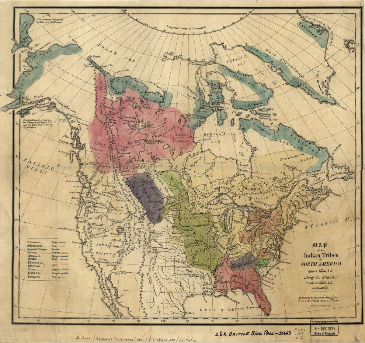
Map of the Indian tribes of North America about 1600 AD, Washington DC, 1836. Map by Albert Gallatin. Courtesy of the Library of Congress Geography and Map Division, loc.gov/resource/g3301e.ct000669/.
Most of the children who lived in US homes spent only short periods of time there, receiving educations in English language and literacy skills as well as in numeracy, literature, and Western philosophical and religious traditions. Those incorporated into US plantation households learned other lessons still as they watched white guardians try to assert mastery over the African and African American women, men, and children they enslaved. These US-educated youth then returned to their tribal nations—and their families—where many took up prominent leadership positions.
The Plumb-pudding in danger, a political cartoon depicting US and European imperialism, February 26, 1805. Cartoon etching by James Gillray. Courtesy of the Library of Congress Prints and Photographs Division, loc.gov/resource/cph.3g08791/.
Despite the brief nature of the majority of these domestic arrangements, those who housed and schooled Indian boys and girls understood their actions as a form of adoption. They saw themselves as absorbing Native children into their white families—however temporarily—and framed their actions as part of a broader initiative on the part of their new republic to assimilate Indian people into its expanding territorial borders. White adopters took their cue from some of the most influential governing officials of their day. As the United States aggressively pushed into Indian territories east of the Mississippi River between 1790 and 1830, a wide range of governing elites declared the importance of assimilating Indian people into the US body politic, which they described as a free white national family. Rather than emphasizing the various forms of violence required to dispossess Native people of their ancestral territories, government officials turned US imperialism into a family story, one supposedly capacious enough to include American Indian people—but not blacks—within "white" kinship systems, the foundational familial frameworks that shaped the rights of citizenship.1I am indebted to the work of black feminist thinkers and scholars in Native American and Indigenous studies and Queer studies in my analysis of family, race, and citizenship. See, for example, Brackette F. Williams, "The Impact of the Precepts of Nationalism on the Concept of Culture: Making Grasshoppers of Naked Apes," Cultural Critique 24 (1993): 143–91; Patricia Hill Collins, "It's All in the Family: Intersections of Gender, Race, and Nation," Hypatia 13, no. 3 (1998): 62–82; Lisa Duggan, Sapphic Slashers: Sex, Violence, and American Modernity (Durham, NC: Duke University Press, 2000); Tiya Miles, Ties That Bind: The Story of an Afro-Cherokee Family in Slavery and Freedom (Berkeley: University of California Press, 2006); Mark Rifkin, When Did Indians Become Straight?: Kinship, the History of Sexuality, and Native Sovereignty (New York: Oxford University Press, 2011). A number of established and would-be government officials themselves incorporated Indian children into their family spaces. Andrew Jackson—perhaps the most infamous figure in nineteenth-century US history for his assaults on Indian sovereignty and Indian lives—embraced the discourse of adoption as he and other US slaveholders worked to acquire Southeast Indian territories for the US plantation economy in the late eighteenth and early nineteenth centuries. After invading Creek territories in what is now Alabama in 1813 and ordering the destruction of a Creek village—and the massacre of the women, children, and men who lived there—Jackson pronounced an "unusual sympathy" for a Creek infant orphaned by his troops. The Southern general sent the child home to be adopted into his plantation household in Nashville, Tennessee.2Andrew Jackson to Rachel Jackson, November 4 and December 19 and 29, 1813, in The Papers of Andrew Jackson, ed. Harold D. Moser, Sharon Macpherson, and Charles F. Bryan Jr., vol. 2, 1804–1813 (Knoxville: University of Tennessee Press, 1985), 444, 494–95, 516; Robert Vincent Remini, Andrew Jackson and the Course of American Empire, 1767–1821 (New York: Harper & Row, 1977), 192–94; Michael Paul Rogin, Fathers and Children: Andrew Jackson and the Subjugation of the American Indian (New Brunswick: Transaction Publishers, 2006), 189.
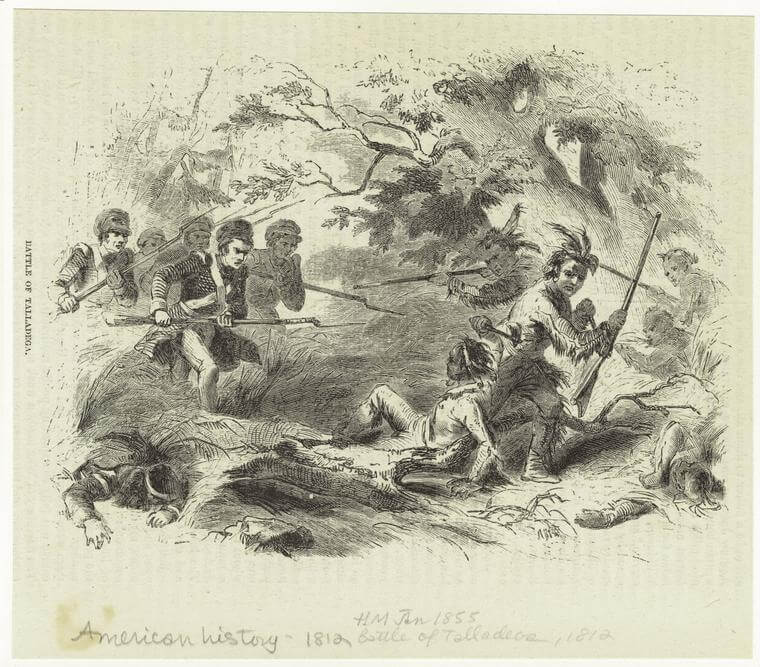
Battle of Talladega, 1855. Engraving by unknown creator. Courtesy of the New York Public Library Art and Picture Collection Division, digitalcollections.nypl.org/items/510d47e0-f6d5-a3d9-e040-e00a18064a99.
In current times, the term "adoption" relates to a specific liberal familial and reproductive arrangement whereby an individual or a two-parent couple legally asserts exclusive parentage rights over a child or children who are not immediate offspring.3The field of adoption studies has grown quite large in recent years. For both histories of adoption as a legal practice in the United States and the social and cultural parameters determining who qualifies as an adoptive parent and an adoptable child, see, for example, Jamil S. Zainaldin, "The Emergence of a Modern American Family Law: Child Custody, Adoption, and the Courts, 1796–1851," Northwestern University Law Review 73, no. 6 (1979): 1038–89; Rickie Solinger, Beggars and Choosers: How the Politics of Choice Shapes Adoption, Abortion, and Welfare in the United States (New York: Hill and Wang, 2002); Laura Briggs, Somebody's Children: The Politics of Transracial and Transnational Adoption (Durham, NC: Duke University Press, 2012); Brigitte Fielder, "'Those People Must Have Loved Her Very Dearly': Interracial Adoption and Radical Love in Antislavery Children's Literature," Early American Studies 14, no. 4 (Fall 2016): 749–80. Within this framework, adopted children are by law full members of their adoptive families, with no fewer rights than children born into these kinship units. The vast majority of the US whites incorporating American Indian children into their homes during the late eighteenth or early nineteenth centuries did not see their roles in these legalistic terms, nor is there any evidence that the Indian children living within these domestic spaces believed themselves to be similar in status to the household's white children. Further, not all white guardians used the term "adoption" per se when it came to defining their relationships with the Indian children in their care. At this time, adoption had not yet been formally codified in the United States. Up until the mid-nineteenth century, in fact, adoption was a rather unpopular practice among US whites due to common beliefs that only "blood" relations should inherit family property as well as to the continued availability of other forms of voluntary and involuntary child transfer, such as wardship and indenture. These prevailing guardianship practices at times left both birth parents and surrogate caretakers with some form of legal authority over the children in question, which could lead to conflicts over parental rights and responsibilities. Those who did formally adopt children during this era typically legitimated their parental status and their adopted children's inheritance rights through specific legislative acts.4Michael Grossberg, Governing the Hearth: Law and the Family in Nineteenth-Century America (Chapel Hill: University of North Carolina Press, 1985), 268–69. Massachusetts would pass "the first modern adoption law in history" in 1851, setting a precedent for, in the words of legal historian Jamil S. Zainaldin, "the judicially monitored transfer of rights with due regard for the welfare of the child and the parental qualifications of the adopters."5Zainaldin, "The Emergence of a Modern American Family Law," 1042–43, emphases in original. See also Grossberg, Governing the Hearth, 269–80.
This book's use of the term "adoption" more flexibly denotes an array of practices focused on the assimilation of Indian youths that were held together by declared desires on the part of US whites to situate Indian people as members of the US body politic. Within this framework, Indian people were supposed to enjoy liberty in the United States, but were also to remain socially and politically subservient to US whites. Unlike people of African descent, whose identities became synonymous with slavery—a status that denied black people the very rights or recognition of kinship—Indians were described as free people who could potentially be incorporated into the US national family, a process that in turn mandated that Indians adopt the social, economic, and familial values associated with white US society.6 On enslaved families' lack of legal rights, see Peter W. Bardaglio, Reconstructing the Household: Families, Sex, and the Law in the Nineteenth-Century South (Chapel Hill: University of North Carolina Press, 1998), 31. On antebellum white society's reluctance to adopt African American children—or to even recognize their status as young people in need of actual protection and care—see Fielder, "'Those People Must Have Loved Her Very Dearly.'" Desires to adopt Indians into the United States reflected ambitions to position Indian people as at once on an equal footing to whites yet simultaneously pliable to white demands. Indians were to be assimilated as free children within the white national family, yet they were also supposed to remain permanent youth whose social, political, and intellectual maturity was constantly deferred.
Those who believed they could incorporate Indian people into the United States on their own terms quickly came to confront Native resistance strategies that they had not expected. A number of American Indian communities saw significant utility in placing their children among US whites for schooling. In the North, those whose lands stood in close proximity to US settlements were especially keen on acquiring for both young girls and boys English language and literacy skills as well as a facility in technical arts— particularly spinning, for women—in order to better position themselves economically and politically with respect to their acquisitive white neighbors. Native families' placement of young children within US homes was not a sign of their subservience to the United States but quite the opposite. The forms of knowledge their children could obtain in the midst of empire would better allow these youths and their extended families to oppose it.
American Indian nations throughout North America had their own indigenous definitions of captivity, slavery, and adoption, ones that evolved over time and, particularly in the Southeast, took on increasingly racialized characteristics in concert with European and US colonial invasions into their homelands.7For examinations of these changing histories, see, for example, Miles, Ties That Bind; Christina Snyder, Slavery in Indian Country: The Changing Face of Captivity in Early America (Cambridge, MA: Harvard University Press, 2010). These shifting understandings of warfare, race, labor, and kinship directly shaped Native decisions to place their children in US homes. Among the Southeast Indians who sent their children away, most appear to have at least entertained ambitions to hold people of African descent as slaves, if they were not already engaging in the practice of racial slavery. Rather than viewing white guardians as the permanent adoptive parents of their children, most of these families sent their children to live in US households with the full expectation that their youth would return home and use the skills they had acquired in US homes in the service of self-determination. And their children did return. Although Andrew Jackson's adopted son—who came to be called Lyncoya—was an exception, many of the Southeast Indian men schooled within the United States used their educations in dramatically different ways than their adopters intended. After learning the ideas and practices forwarded by their US mentors—including those revolving around antiblack racism and plantation slavery—they drew upon their knowledge and experiences to oppose US Southerners seeking to dispossess tribal nations of their homelands.
While the number of Indian children living in US households was relatively small, the study of their lives and their migrations is illuminating.8 It is impossible to fully assess the numbers of Native children "adopted" by US whites during this period of study due to uneven record keeping on the part of US educational institutions and missionary organizations, the transient nature of many of these "adoptions," and the fact that many records have simply not survived into the present. This book accounts for small numbers (fewer than thirty). However, all told, there were an additional forty-two Indian children living in Cornwall, Connecticut, over the course of the 1810s and 1820s, as well as fluctuating numbers of Native youth at a residential school called Choctaw Academy in Blue Springs, Kentucky, opened in 1825. In addition, in 1824 the US House Committee on Indian Affairs estimated that over eight hundred Indian children had attended mission schools within Indian territories. See Francis Paul Prucha, The Great Father: The United States Government and the American Indians (Lincoln: University of Nebraska Press, 1984), 152. For scholarly accounts regarding the numbers of children at Cornwall mission school and Choctaw Academy, see John Demos, The Heathen School: A Story of Hope and Betrayal in the Age of the Early Republic (New York: Knopf, 2014), 231; Carolyn Thomas Foreman, "The Choctaw Academy," Chronicles of Oklahoma 6, no. 4 (1928): 453–80. The political and familial commitments of white adopters, American Indian parents, and adopted Indian children offer a unique vantage point into eighteenth- and nineteenth-century nation building on the part of the early US republic and those American Indian nations forced to contend with it. The expansionist visions of US settlers and the complex forms of resistance engaged in by American Indian women and men in the decades before the forced relocation of tens of thousands of Indian people living east of the Mississippi River to the trans-Mississippi West reveal how a subset of whites and Southeast Indians used adoption, kinship, and slavery to impose and resist US imperial rule. For white adopters, incorporating Indian children into their homes supported US settler expansion. For the select group of American Indian women and men who placed their girls and boys in US homes, acquiring the forms of knowledge valued within the settler societies in their midst was a crucial step in assuring political, economic, and territorial sovereignty.
By the early 1800s a small but powerful class of Southeast Indian elites saw white slaveholders' interest in incorporating Native children into their plantation homes as particularly useful. With US planters invading the Southeast at unprecedented rates, these Choctaw, Creek, Cherokee, and Chickasaw women and men sent sons to acquire the racialized educations that increasingly supported political and economic authority in the slaveholding South. US expansionists would come head-to-head with these Native strategists in the 1820s. Through their selective engagement with some of the colonial logics and practices that drove US settler expansion in general, and the plantation economy in particular, adopted Southeast Indian sons effectively thwarted state and federal claims to their lands, so much so that Southern slaveholders advocated for the forced removal of Southeast Indian nations west of the Mississippi River in 1830.9As scholar Alexandra Harmon argues, "the banishment of Cherokees, Choctaws, Chickasaws, and Creeks was a response to competition between peoples with comparable agendas and comparable enterprising classes." Alexandra Harmon, Rich Indians: Native People and the Problem of Wealth in American History (Chapel Hill: University of North Carolina Press, 2010), 93. Indians' access to US domestic regimes proved more threatening than most US imperialists had anticipated. Instead of being solely an imperial practice of assimilation, adoption proved a Native-driven strategy of infiltration, allowing elite Indian men privileged access to and knowledge about powerful and influential spaces within an expanding US empire.

The transfer of American Indian children into foreign homes and institutions during the post-Revolutionary period reflects both a continuity in European and Euro-American relationships with Indian people and a distinct moment in North American history. On the one hand, the practice existed prior to the formation of the United States and would endure long after the forcible relocation of American Indian nations during the 1830s. Well before Molly McDonald sent her son to live in a Mississippi plantation household or Andrew Jackson raided the Creek Nation, American Indian people found themselves living in European and Euro-American homes. Christopher Columbus enslaved Native people from the Caribbean after his first voyages to the Americas, inaugurating a practice that persisted among the French, Spanish, and British empires and within some US settlements well into the eighteenth and nineteenth centuries.10Samuel Eliot Morison, The European Discovery of America: The Northern Voyages, A.D. 500–1600 (New York: Oxford University Press, 1971), 105; Andrés Reséndez, The Other Slavery: The Uncovered Story of Indian Enslavement in America (Boston: Houghton Mifflin Harcourt, 2016), esp. 13–45. A number of recent monographs and edited volumes have documented British, French, Spanish, and US participation in the enslavement of American Indians. See, for example, ibid.; Alan Gallay, ed., Indian Slavery in Colonial America (Lincoln: University of Nebraska Press, 2010); Alan Gallay, The Indian Slave Trade: The Rise of the English Empire in the American South, 1670–1717 (New Haven, CT: Yale University Press, 2002); James F. Brooks, Captives and Cousins: Slavery, Kinship, and Community in the Southwest Borderlands (Chapel Hill: University of North Carolina Press, 2002); Ned Blackhawk, Violence over the Land: Indians and Empires in the Early American West (Cambridge, MA: Harvard University Press, 2008); Brett Rushforth, Bonds of Alliance: Indigenous and Atlantic Slaveries in New France (Chapel Hill: University of North Carolina Press, 2012). In 1561 Spanish adventurers took a young man—who some believe was probably a member of the Chiskiak tribe—from the Chesapeake region. Dubbed Don Luis de Velasco, he was trained in the Spanish language and Christian religion in Mexico and then sailed back to the Chesapeake on two Spanish colonization expeditions to serve as a guide and interpreter. (Much to Spanish dismay, Don Luis apparently sabotaged both expeditions, eventually returning to his people in 1570).11Camilla Townsend, Pocahontas and the Powhatan Dilemma, American Portraits (New York: Hill and Wang, 2005), 7–9. In 1584 English explorers attempting to establish their empire's first colonies in North America carried two Algonquian-speaking Indians from the Chesapeake region back with them to England. One was Manteo, the son of the leader of the Croatoan polity, and the other was Wanchese, who hailed from the Secotans. These young men's voyage appears to have been more voluntary than those migrations previously orchestrated by the Spanish, as the English left two of their own men in exchange for their Native travelers. Manteo and Wanchese, however, would develop very different impressions of their European hosts during their stay in London, which would influence their relationships with British colonists upon their later return to their homelands in what would become known as Virginia. Manteo declared himself fairly treated and developed a lasting alliance with British colonists, one that he undoubtedly hoped would better conditions for his own people. Wanchese, on the other hand, did not trust the British empire and, once back in his own community, worked to unseat the unwelcome settlers who proved to be disloyal and treacherous in their treatments of Indian people.12James Horn, A Kingdom Strange: The Brief and Tragic History of the Lost Colony of Roanoke (New York: Basic Books, 2010), 55, 60–61, 81–82, 92, 155, 157–60.
The Roanoke settlement that threatened Wanchese's community disappeared within a matter of years. However, the Jamestown settlement that would arise in its wake also circulated Indian people through the British metropole, most famously in the case of Amonute, who would become known to the British by her nickname, Pocahontas.13Townsend, Pocahontas and the Powhatan Dilemma, 13–14. Initially held hostage by Jamestown settlers, Amonute eventually married into the British community and traveled to London with her husband and their infant son. Like Manteo, she made the journey to improve conditions for her Native polity— in this case the powerful confederacy built up by her father, Powhatan—as the English took more and more territory by force. Her death in London from illness cut short her attempts at diplomacy and the promotion of coexistence between the two polities.14 Ibid., esp. 85–158. During the seventeenth and eighteenth centuries, as British colonists claimed territories in what would become known as New England, as well as in the mid-Atlantic and in the South, other Indian people would choose to enter into English households—and, later, into English-run schools—in order to learn the English language and understand the spiritual beliefs that they believed might help them to better navigate British settlement and the devastation it wrought.15 Jean M. O'Brien, Dispossession by Degrees: Indian Land and Identity in Natick, Massachusetts, 1650–1790 (Lincoln: University of Nebraska Press, 2003), 54; Jill Lepore, The Name of War: King Philip's War and the Origins of American Identity (New York: Vintage Books, 1999), 30–39. For a useful overview of Indian schooling by European-descended settlers, see Margaret Connell Szasz, Indian Education in the American Colonies, 1607–1783 (Lincoln: University of Nebraska Press, 1988). Others still found themselves held in colonial households by force. Indeed, European settlers' desires for Indian slaves and indentured servants put countless Indian people—particularly women and children—in Euro-American homes, dramatically reshaping Native politics, communities, and even nations in the process.16Gallay, Indian Slave Trade; Robbie Ethridge and Sheri M. Shuck-Hall, eds., Mapping the Mississippian Shatter Zone: The Colonial Indian Slave Trade and Regional Instability in the American South (Lincoln: University of Nebraska Press, 2009); Gallay, Indian Slavery in Colonial America; Ruth Wallis Herndon and Ella Wilcox Sekatau, "The Right to a Name: The Narragansett People and Rhode Island Officials in the Revolutionary Era," in After King Philip's War: Presence and Persistence in Indian New England (Hanover: University Press of New England, 1997), 115, 121–24, 127.
Jumping forward to the close of the nineteenth and first decades of the twentieth century, the US federal government endorsed the forced relocation of American Indian children into boarding schools, hoping to erase a new generation's indigenous cultural and kinship ties and, by extension, their claims to their homelands.17David Wallace Adams, Education for Extinction: American Indians and the Boarding School Experience, 1875–1928 (Lawrence: University Press of Kansas, 1997). For how Native parents and children navigated the trauma of this history, see Brenda J. Child, Boarding School Seasons: American Indian Families, 1900–1940 (Lincoln: University of Nebraska Press, 2000). Here, too, Indian children went into the households of US whites as families "adopted out" from boarding schools, a practice that often translated into the indenture of Indian girls and boys as laborers on US farms and in white homes.18See Sarah Deer, The Beginning and End of Rape: Confronting Sexual Violence in Native America (Minneapolis: University of Minnesota Press, 2015), 71. For a compelling memoir of one man's experiences of being put in a residential school and then placed in an abusive white family in the 1940s, see Peter Razor, While the Locust Slept: A Memoir (St. Paul: Minnesota Historical Society Press, 2002). Leslie Marmon Silko provides a powerful novel that engages with the history of this practice. See Leslie Marmon Silko, Garden in the Dunes: A Novel (New York: Simon & Schuster, 2000). Throughout the twentieth and into the present century, American Indian families have faced ongoing struggles to protect their children from US adoption and fostering practices. State and federal agencies and private adoption services continue to undermine both the familial and national rights of indigenous people by transferring children away from their Native kin and tribal communities to wealthier—and most often white—families, despite existing laws aimed to protect Indian families and nations from precisely these kinds of predatory processes. In the words of Muscogee legal scholar Sarah Deer, such ongoing forms of child removal have "sent a variety of messages to tribal communities, particularly to mothers. The dominant society disapproved of the way Native people parented."19Deer, The Beginning and End of Rape, 85. See also Briggs, Somebody's Children, 59–93; Laura Briggs, "Why Feminists Should Care about the Baby Veronica Case," Indian Country Today Media Network, August 16, 2013, http://indiancountrytodaymedianetwork.com/2013/08/16/why-feminists-should-care-about-baby-veronica-case-150894; Laura Sullivan and Amy Walters, "Native Foster Care: Lost Children, Shattered Families," NPR News, October 25, 2011, http://www.npr.org/2011/10/25/141672992/native-foster-care-lost-children-shattered-families.
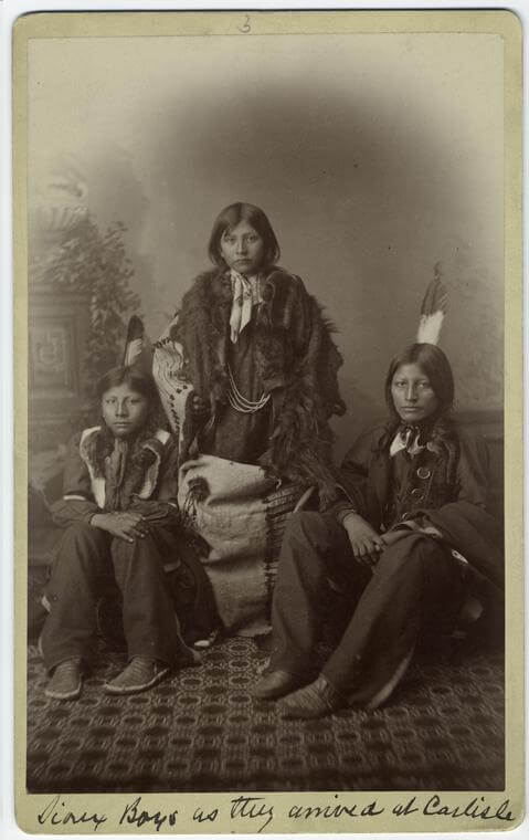
Sioux boys as they arrived at Carlisle, Pennsylvania, ca. 1892. Photograph by unknown creator. Courtesy of New York Public Library Art and Picture Collection Division, digitalcollections.nypl.org/items/510d47e1-1b90-a3d9-e040-e00a18064a99.
Like their predecessors and their later counterparts, white adopters in the Revolutionary and early national period believed themselves to be superior to American Indian people and drew upon this sense of entitlement as they encouraged the separation of Native children from their families and into white-controlled spaces. They believed the right to have children and to control the upbringing of young people was the privilege of white settlers and not of those whose lands they invaded. Settler colonialism revolves around the foreign settlement of indigenous land and the subsequent declaration on the part of colonists of their own nativity to indigenous space, a move that correspondingly defines indigenous people as foreigners in, or alien to, their own homelands.20See, for example, Jean M. O'Brien, Firsting and Lasting: Writing Indians out of Existence in New England (Minneapolis: University of Minnesota Press, 2010); Patrick Wolfe, "Settler Colonialism and the Elimination of the Native," Journal of Genocide Research 8, no. 4 (December 2006): 387–409; J. Kēhaulani Kauanui and Patrick Wolfe, "Settler Colonialism Then and Now: A Conversation," in special issue, ed. Michele Spanò, Politica & Società (June 2012): 235–58. Within this formulation, indigenous people are not only positioned as unworthy of reproducing their own communities as they see fit but are actively prevented from doing so. The goal of settlers is to circumscribe or eliminate both the power and the populations of indigenous people so as to make lands and resources available to colonizers.21Wolfe, "Settler Colonialism and the Elimination of the Native." Within the context of British and US settlement of North America, when settlers encouraged—or even demanded—the migration of American Indian children into their homes, they were hoping to erase or severely limit autonomous Native futures outside of the purview of the British colonies or the United States.
During the early national period, US officials were formulating expansionist policies oriented around the geopolitics of racial slavery and in direct response to specific American Indian resistance strategies developed to thwart US imperial ambitions. In this particular historical moment, the politics of adoption took on singular importance, becoming a means to define citizenship within a slaveholding republic and to undermine indigenous resistance struggles based upon pan-Indian unity movements and transatlantic commercial, trade, and military alliances with European empires. Adoption signaled who could be incorporated into a free white national family—and who could not—and structured imperial policies aimed at assimilating American Indian people and the nations to which they belonged into a US "domestic" economy. As Indians' powerful international connections began to crumble in the face of US policies and shifting European geopolitical interests by the first decades of the nineteenth century, however, adoption also became a way for Native people to defend themselves against exploitative US international agendas and economic systems, especially as the possibilities for military defense evaporated.
Racial slavery—and the ideas about "blackness," "whiteness," and "Indianness" it helped to engender—sat at the heart of US contests over human beings and territory. It determined who would—or could—occupy specific household and territorial spaces, shaped economic relationships and political governance across US settlements, and calibrated the kinship systems informing how individual women, children, and men were able to labor, live, and love. With plantation slavery directly driving US colonization of the Southeast—the region that would become known as the "Deep South"—and a small but influential group of Southeast Indian women and men themselves beginning to hold black people as property, chattel slavery came to shape decisions by a number of mothers, fathers, uncles, and aunts to send children to live in the United States. The women and men who placed their children within US slaveholding households acted in ways to better position themselves—and often their tribal nations more broadly—within rapidly changing imperial worlds. Yet they also subjugated people of African descent, a move that distinguished them from the vast majority of the individuals living within their Native nations, not to mention in American Indian nations across the continent.22For histories of slavery in Indian country, see, for example, James Taylor Carson, Searching for the Bright Path: The Mississippi Choctaws from Prehistory to Removal (Lincoln: University of Nebraska Press, 1999), 80; Miles, Ties That Bind, 75; Celia E. Naylor, African Cherokees in Indian Territory: From Chattel to Citizens (Chapel Hill: University of North Carolina Press, 2009), 17; Theda Perdue, Slavery and the Evolution of Cherokee Society, 1540–1866 (Knoxville: University of Tennessee Press, 1979); Snyder, Slavery in Indian Country. It lent them their own unusual sympathies with the very slaveholders who sought to dispossess them of their homelands.
By following a series of families and the ways in which the lives of the individuals who composed them intersected across nations and empires, the stories told in the following chapters seek to provide an intimate glimpse into the history of nation building—and of attempts to destroy indigenous nations—in post-Revolutionary North America.23Drawing on the work of sociologist Patricia Hill Collins, historian Tiya Miles argues that the "family can . . . be read as a barometer for . . . society, tracing and reflecting the atmospherics of social life and social change." Ties That Bind, 3. For compelling studies on the intersections of family relationships and Euro-American imperialism, see ibid.; Susan Sleeper-Smith, Indian Women and French Men: Rethinking Cultural Encounter in the Western Great Lakes (Amherst: University of Massachusetts Press, 2001); Juliana Barr, Peace Came in the Form of a Woman: Indians and Spaniards in the Texas Borderlands (Chapel Hill: University of North Carolina Press, 2007); Tiya Miles, The House on Diamond Hill: A Cherokee Plantation Story (Chapel Hill: University of North Carolina Press, 2010); Anne F. Hyde, Empires, Nations, and Families: A New History of the North American West, 1800–1860 (New York: Ecco, 2012); Emma Rothschild, The Inner Life of Empires: An Eighteenth-Century History (Princeton, NJ: Princeton University Press, 2012). Adoption, expansion, and slavery would serve as important and intertwined practices in these familial, national, and imperial stories, shaping the daily lives of people of American Indian, African, and European descent and influencing US and Southeast Indian political governance. Ideas about kinship and race became central in competing claims to land, labor, and citizenship in the post-Revolutionary era. They directly informed imperial policy decisions and articulations of self-determination, structuring a diverse range of struggles for individual and collective sovereignty and freedom in the process.
Acknowledgments
Southern Spaces thanks Harvard University Press for their permission to reprint this excerpt from the introduction of Indians in the Family: Adoption and the Politics of Antebellum Expansion.
About the Author
Dawn Peterson is an assistant professor of early North American and US history at Emory University. In her research, she considers the roles of race, gender, and kinship in the history of US capitalism, settler colonialism, and slavery, particularly in the post-Revolutionary period. Her book Indians in the Family: Adoption and the Politics of Antebellum Expansion (Cambridge, MA: Harvard University Press, 2017) looks at a group of white slaveholders who adopted Southeast Indian boys (Choctaw, Creek, and Chickasaw) into their plantation households in the decades following the US Revolution. While these adoptions might seem novel at first glance, they in fact reveal how the plantation household—and the racialized kinship structures that underpin it—increasingly came to shape human life for American Indians, African Americans, and Euro-Americans after the emergence of the United States. Peterson has received fellowships to support this work from the American Antiquarian Society, Harvard University, the Library Company of Philadelphia, the Huntington Library, the McNeil Center for Early American Studies at the University of Pennsylvania, and the Newberry Library.
]]>Review

The thirst for information and the power of lies is "a very old problem," writes Alejandra Dubcovsky, yet Informed Power: Communication in the Early American South is more than a lament (215). By examining networks that included colonists from Spain, France, and England as well as American Indians and enslaved Africans, she excavates an "early South" characterized by messiness, complexity, and indigenous power rather than the inexorable westward march of European domination. For Dubcovsky this early South—"the composite societies who came to inhabit the colonies of South Carolina, Georgia, Florida, and parts of Louisiana"—is a "socio-cultural model" that allows her to explore the historical complexities of an increasingly multiethnic space and not "some projection backward in time of what would later become the Confederacy" (4).
In addition to traditional colonial sources, Dubcovsky delves into material culture, oral traditions, linguistics, and iconography to reveal how, from the pre-Columbian era to the middle of the eighteenth century, a diversity of peoples in what the Spanish called la tierra adentro—literally "the land inside"—communicated and mis-communicated with each other. Informed Power's insufficient spatial theorization becomes most apparent where Dubcovsky vacillates between the historiographically loaded term—the “South”—and la tierra adentro. Dubcovsky devotes only a paragraph to explicating the decision to use "early South" to designate a "region" where this term had little contemporary meaning.

Map identifying Spanish treasure fleets, ca. 1720. Map by Emanuel Bowen. Courtesy of the Library of Congress Geography and Map Division, loc.gov/resource/g4390.ct002233.
Organized chronologically and thematically, Informed Power begins in a North America without Europeans and ends just as the English solidify their hold in Carolina and Georgia. Dubcovsky, an assistant professor of history at the University of California–Riverside, divides the book into three parts. The first—"What"—concerns the sort of information European settlers most desired: gold. Upon hearing from an Indian that a captured Spaniard named Juan Ortiz was nearby, Juan de Añasco "stopped listening and began celebrating certain that he had found oro (gold)" (31). Even when Europeans received useful information, "they did not know how to evaluate it properly," and evidently misunderstood it as relevant to the discovery of mineral wealth (32).
In "Who," Dubcovsky outlines who "acquired and spread" information as a way to come to terms with this volatile and disorderly geography (7). As a means to maximize his personal power and the safety of his Florida town, Apalachicole, an Indian named Pentocolo, for example, operated simultaneously as a "Spanish ally and an English sympathizer" (143).

And in the final section—"How"—Dubcovsky examines the Yamasee War to articulate how communication networks operated (and didn't). As the war progressed, the Spanish began "investing in particular Indians" because they began to treat "information as a commodity that could be purchased" (201). What, though, about "why"? "This absence is deliberate," writes Dubcovsky, "because the answer is clear: power." The entire book offers an answer to why. Although the connection between information and power might seem relatively facile, Informed Power reveals it to be "anything but simple and obvious" (8).

Three examples of Mississippian culture avian themed repoussé copper plates, April 20, 2012. Image by Herb Roe. Courtesy of Wikimedia Commons. Creative Commons license CC BY-SA 3.0.
Dubcovsky begins her analysis in a place characterized by the colonizing power of Cahokia, a pre-Columbian urban center and chiefdom at the confluences of the Mississippi, Illinois, and Missouri Rivers (3). As she demonstrates in discussing the Commerce Map—a rock drawing (located about 150 miles south of present-day St. Louis) that is the oldest known cartographic representation in eastern North America—communication networks connected a wide geography well before Europeans arrived. The territory, however, looked dramatically different from that encountered by Europeans. Rather than power being diffuse, communication networks were centered at Cahokia (represented by a large falcon glyph). By dissecting the relationship between communication and power in a North America without Europeans, Dubcovsky demonstrates that exchange and control of information was central to the way American Indians organized their worlds. While much would change with the arrival of Europeans, the foundations for early colonial relations were established earlier. Rather than looking forward to an antebellum, plantation South, Dubcovsky persistently qualifies and enhances her arguments about indigenous power by gesturing towards the pre-Columbian past.
. Courtesy of the Library of Congress Prints and Photographs Division, loc.gov/resource/cph.3c04322/.")

Top: De Soto and Vitachuco, 1898. Image by George Gibbs. Originally published in Grace King's De Soto and his Men in the Land of Florida (The Macmilliam Company, 1898). Courtesy of the Library of Congress Prints and Photographs Division, loc.gov/resource/cph.3c04322/.
Bottom: Timucua men meeting settlers, ca. 1562. Lithograph. Courtesy of Wikimedia Commons. Image is in the public domain.
Informed Power's early chapters reveal the power held by Indians in cross-cultural communication. Once Cahokia collapsed—before European arrival—a new social geography emerged, still defined by chiefdoms, but where power was more diffuse and communication primarily oral. In this space, as distinct from urban centers such as Cahokia, trails were of the utmost importance, and for much of the colonial period Indians controlled them. "These paths," writes Dubcovsky, "bound distant Indian nations together, even as they pitted them against each other" (21). When de Soto traveled in the mid-sixteenth century, he was at the mercy of Indians. And once the Spanish, French, and eventually English established permanent settlements, they relied on Indians to glean information about the strategies of their European rivals. No matter what sort of grand plan imperial officials hatched across the Atlantic, the constraints imposed by Indian power mattered more. The malleability of information is especially clear in Dubcovsky's treatment of the 1656 Timucua Rebellion. La Florida's governor, Franciscan missionaries, and Timicua Indians each worked to channel the flow of information and shape it to their particular narrative. The governor blamed the Franciscans for causing unrest. The Franciscans gestured towards the abusive policies of the colonial government. And the Timicuas highlighted their dissatisfaction with "having to serve as cargadores," carrying food and supplies across La Florida for the Spanish. Using two visual representations of information networks to augment her analysis (83, 94), Dubcovsky argues that "The different versions of the uprising expose the multiple ways that information was gathered, interpreted, and networked in the early South" (96).
In most instances of cross-cultural communication, the who mattered just as much (if not more) than the what. By examining a large cast of historical actors, Dubcovsky illuminates the motivations of those establishing and disrupting connections. In a geography shattered by disease, slavery, and violence, varying motivations colored information exchange. It obscures complexity to talk only about the Spanish or the English or Indians—or even Yamasees or Timucuas or Cherokees. Individual motivations are not easily mapped onto an entire people. Pamini, for example, was a female Yspo leader who lived near Santa Catalina in the early 1670s. We know very little about the Yspo—they were probably a group of Muskogean-speaking refugees who had coalesced as a way to deal with slave raids. After a meeting with the Spanish captain Argüelles near Port Royal, in which Pamini provided him with news that the English in Charles Town were relatively weak—contradicting the information of other Indian informants, Argüelles began to trust her.
Over the next three years Pamini told the Spanish much about the English. She also told the English much about the Spanish. Whether true or not, Pamini's information provided a means to an end: she able to secure trade with the Spanish and English while protecting her people from enslavement. "News was a powerful weapon," Dubcovsky concludes, "it was both the sword Pamini used to defend her authority and the shield she wielded to protect her town" (109). Sowing confusion was integral to Pamini's power. By identifying who transmitted information and mis-information, Dubcovsky provides a schematic of layered, messy, and constantly shifting networks.
Information connecting the peoples of this this colonial landscape also pushed them apart—most apparently when the tenuous networks broke down. As the Yamasee War exposed factions, the English could no longer rely on their old networks. Working to refashion their information-gathering, they began to "dictate, not negotiate, the terms of exchange" (191). The Spanish were also forced to adapt to a changing social geography. As the Yamasee War progressed they began to privilege information from select Indian leaders, not from just anyone who would talk to them. What emerged were "bitter, competing," and "coexisting articulations of power" (214).
While Dubcovsky does an excellent job of weaving disparate strands of evidence in Spanish, English, French, and indigenous language sources into a larger tapestry characterized by the irony of communication, she leaves a number of loose ends. Mentioning the power of rumors and the struggle colonial actors had identifying them, she doesn't examine this expressive form nor cite Gregory Evans Dowd's Groundless, a study of rumor in early America. Lies receive similar short shrift, without mention of Joshua Piker's The Four Deaths of Acorn Whistler.
Informed Power's blurring of distinctions between "space" and "place" sometimes obscures the book's arguments. Writing that the "early South's" communication networks connected "discrete places" and that these networks were crucial to the "creation, development, and growth of colonial spaces,'" Dubcovsky doesn't examine how local places (and abstract spaces) would mean something different to indigeneous groups than to colonizing powers (4). Citing Keith Basso's Wisdom Sits in Places—a favorite among historians of American Indians—she agrees that "Indian place names offer perhaps the most enduring clue to how Indians conceived their world" (45). Yet, without citing an example, Dubcovsky concludes that the "Indian place names of La Florida show an ethnocentrism that was supported not by isolation but rather was fostered by a deep awareness of others" (45).
Informed Power is, however, a remarkable achievement. Not only does Dubcovsky illuminate the significance of communication networks to the emergence of an early South, she does so in a way that highlights indigenous power where it is often ignored—powerful Indians were not only denizens of the American West.
About the Author
Nathaniel Holly is a PhD student at the College of William and Mary. His research interests focus on the intersections of urban, colonial, and indigenous histories in the early American southeast. His recent work includes book reviews in Historical Geography, Chronicles of Oklahoma, the South Carolina Historical Magazine, and H-Net, as well as articles, such as "'Living Memorials to the Past': The Preservation of Nikwasi and the 'Disappearance' of North Carolina's Cherokees," in the North Carolina Historical Review (July 2015) and "Transatlantic Indians in the Early Modern Era," in History Compass (Oct. 2016).
]]>
Whenever the concepts of diaspora and indigeneity come together, scholars tend to ascribe oppositional power to them. Diaspora implies transnational if not global movement, displacement, and attenuation while indigeneity connotes originality, belonging, and rootedness. In drawing together diaspora and indigeneity to compass the complexities and ambiguities of indigenous peoples' lives, scholars of indigenous diasporas have closed the gap between the two concepts. They suggest that in spite of diasporic indigenous persons' relationships to multiple places—a lost homeland, a current abode, a far-away site of work—and to multiple identities—clan, tribal, historical, racial, and political—diasporic indigenous peoples can and do remain rooted in common memories, traditions, and pasts.1William Safran, "Diasporas in Modern Societies: Myths of Homeland and Return," Diaspora 1 (July 1991): 83–99; Michele Reis, "Theorizing Diaspora: Perspectives on 'Classical' and 'Contemporary' Diaspora," International Migration 42 (June 2004): 41–60; Robin Cohen, Global Diasporas: An Introduction (Seattle: University of Washington Press, 1997); Rogers Brubaker, "The 'Diaspora' Diaspora," Ethnic and Racial Studies 28 (January 2005): 1–19; Paul Burke, "Indigenous Diaspora and the Prospect for Cosmopolitan 'Orbiting': The Warlpiri Case," Asia Pacific Journal of Anthropology 14 (August 2013): 304–7; James Clifford, "Indigenous Articulations," Contemporary Pacific 13 (Fall 2001): 470–72, 478–79; Robin Delugan, "Indigeneity across Borders: Hemispheric Migrations and Cosmopolitan Encounters," American Ethnologist 37 (February 2010): 41–2.
Gregory D. Smithers's The Cherokee Diaspora offers one of the first diasporic studies of Native North America. The idea of diaspora allows Smithers to remove Cherokee history from the usual linear settler/colonial paradigm that frames the subject and to instead address long and recurring cycles of Cherokee dislocation, movement, and coalescence. The problems that beset any diasporic people—a sense of belonging, of identity, and of home—have confronted Cherokees for centuries. How they responded to such challenges has varied over time as sense of self and place shifted from the sacred fires that centered each town in the eighteenth century to engagement with the federal government's so-called "civilization" policy in the early nineteenth century, to the valorization of blood quantum later in the nineteenth century, to federal law and competing indigenous notions of what it means to be Cherokee today. While such different formations enabled Cherokees to maintain a sense of peoplehood, there was often little agreement over who counted across time and space as a Cherokee. Contests over Cherokee identity became an insistent theme, but, Smithers concludes, one basic determinant above all others has defined being Cherokee since the 1830s: their shared history of expulsion from an ancestral homeland and their arduous and deadly forced march to the West along what is known as the Trail of Tears.
Scholars have wrestled with how to interpret and depict the cyclical unity of time, space, and place that gives indigenous peoples powerful identities and senses of place.2William Cronon, Changes in the Land: Indians, Colonists and the Ecology of New England (New York: Hill and Wang, 1983); Keith H. Basso, Wisdom Sits in Places: Landscape and Language Among the Western Apache (Albuquerque: University of New Mexico Press, 1996); James Taylor Carson, "Ethnogeography and the Native American Past," Ethnohistory 49 (Fall 2002): 765–784; Robbie Ethridge, Creek Country: The Creek Indians and Their World (Chapel Hill: University of North Carolina Press, 2003). Smithers makes a promising start when he grounds his study in two Cherokee sensibilities, tohi and osi, which embody notions of flow, equanimity, and power. An individual's actions always implicate him or her in the flow of the world, posing a constant challenge to remain balanced and to flow well (53–4). By setting in motion a space where people flow, where rivers and mountains are alive, where the East is associated with the beginning of life and the West with its inevitable end, Smithers embeds Cherokees within a cosmological space that holds great promise as an interpretive entry into their past.


Such an auspicious spatial framing wanes over the course of The Cherokee Diaspora. As Smithers' explication of diaspora and modern identity becomes unmoored from the senses of space and place that tied them with great depth and specificity to their ancestral homeland, what remains is a fairly conventional narrative of post-removal Cherokee history. Cherokees, however, had emerged from the earth, their mother. What we gloss as trees, rocks, mountains, springs, streams, animals, and plants knit the Cherokees' knowledge of the world and its origins into a tight narrative that informed everything: how a child should behave, how to make a medicine, how to achieve peace. They were not people who inhabited a natural world; instead, the Cherokees were so implicated within the workings of the world that their lives played out in a complex mixture of time, space, and place that can be neither imagined nor perceived when disaggregated. The text also neglects a register of the profound, unexplored impact of losing their homeland. Loss of place often triggers drastic transformations in a sense of past, self, and future. Reconstituting themselves in Indian Territory was not just a struggle to resettle, build new homes, plant new gardens, and learn about new weather patterns. It demanded a reimagination of who the Cherokee were, how they connected to the world, and how they connected to their former ancestral home—all processes that lie at the core of the diasporic experience and demand closer attention.3Andrea L. Smith and Anna Eisenstein, Rebuilding Shattered Worlds: Creating Community by Voicing the Past (Lincoln: University of Nebraska Press, 2016), 3–4, 11–13.
In a longer history, Cherokees arrived in the southern Appalachians about four-thousand years ago, having left their Iroquoian homeland, which itself was once a place of arrival for ancestors thousands of years before. The Cherokee diaspora that concerns Smithers began at the end of the American Revolution when a handful of prescient leaders in mountain towns of what is today Tennessee, Georgia, and North Carolina ascertained that the long knife republic was not going to abide by borders negotiated by the crown they had just overthrown. In anticipation of this invasion, Cherokees began to head west in search of places to ensure that they could remain in flow and balance. Over the following decades many more followed while others headed for the Mexican province of Texas in search of respite from Anglo-American encroachments. By 1830, Texas Cherokees numbered several hundred while around five thousand western Cherokees settled in present-day western Arkansas and eastern Oklahoma. Many of the 16,500 who still inhabited their ancestral homeland in the states of Georgia, Tennessee, and North Carolina regarded their far-flung kin as either outsiders or as rivals who had abandoned them in their fight against the federal and state governments and who had turned their backs on the adoption of Anglo-American cultural norms. But when in 1838 and 1839 the US army expelled the remaining eastern Cherokees from Tennessee, with the exception of a few hundred who remained in western North Carolina, the relocation of the nation to what became known as Indian Territory was complete.


The land once home to a few thousand western Cherokees (what is today southeastern Oklahoma) transformed in the early 1840s into the site of a new nation that had to remake itself out of a population segmented by different histories of movement, identity, and resistance. In the wake of assassinations and bitter civil strife, the former leader of the eastern Cherokees, John Ross, forged a coalition in defense of their new homeland, a renewed sovereignty, and a proactive adaptation to life in Anglo-America. Over time the people who remained in North Carolina found themselves estranged from their western kin and increasingly excluded from the new nation's exclusive claims to Cherokee identity.
Two subsequent events, abolition and allotment, undermined the Cherokee identity fashioned in Indian Territory. Emancipation at the end of the Civil War created a new set of Cherokees out of the nation's enslaved population whose skin color made them anathema to most other Cherokees. The freed peoples' claims to certain legal rights and benefits hastened the nation's embrace of US racial norms and laws in order to exclude freed people from the census rolls that determined membership in the nation. Then, in the early 1900s, the federal government allotted most of the Cherokees' western land for sale to speculators and homesteaders. Allotment transformed the nation from a place that could be mapped on the ground to a space of the mind and heart that could only be felt and enacted through cultural rites, church services, and social gatherings. How Cherokees remained conscious of themselves as a people and how they reformulated a sense of self after allotment demands a deeper investigation than Smithers offers. It is unclear whether and how a sense of spatiality informed debates over who belonged and who did not. In eliminating formerly enslaved men, women, and children from the nation's rolls, Cherokees undertook a purging of collective genealogy and a restructuring of the spaces they inhabited. A different kind of removal required the political and racial separation of neighbors and kin.


Two world wars and the Great Depression further disrupted Cherokee life. Poverty, urban opportunities, and service overseas pushed and pulled Cherokees across the country as they sought belonging and work in US cities. By the 1970s, most still called Oklahoma home but thousands had sought better opportunities in California and other states. Some made it as far as Hawaii and a few even lodged applications with the Australian government. Meanwhile, the Cherokees in North Carolina had rebuilt their land base as the Qualla reserve and gained separate federal recognition to set themselves up as a second Cherokee nation.
In spite of confusing and complicated histories of dislocation, violence, and rivalry, Smithers argues that there is still a Cherokee people whose identity transcends a myriad of political, racial, and geographical divisions. Cherokees are, Smithers argues, defined by their shared diasporic experiences of the Trail of Tears. His inability to anchor consistently his interpretation in indigenous concepts of flow and propriety fails to clarify how understanding their expulsion can be usefully explored as a diaspora. At the heart of the story of the Cherokee diaspora sit the brute facts that they lost most of their ancestral homeland, were driven by force of arms from their homes, reconstituted themselves in a new homeland which they subsequently lost, and then underwent bitter struggles over who counted as a member of the nation and who did not. When held apart from specific ethnogeographic considerations, such a narrative comports well with other such studies. If, however, Smithers had probed more deeply the interdependence of peoplehood, place, and memory, and pushed his analysis back to the much earlier migration that brought the Cherokees to their southern homeland, he might have better represented the pain of expulsion from not just an ancestral homeland but from a living being that had borne and nurtured the Cherokees for millennia.
Consider the Cherokee dead, the ghosts that haunt TVA reservoirs, inhabitants of ancient cemeteries that lie beneath economic development projects, and occupants of forlorn mounds—the beings who tie the living to the past and to the land. They have stories to tell. According to notions of tohi and osi the dead are never really dead but cohabit with the living and the unborn. When real estate development and other forms of excavation disturb or destroy the Cherokee dead, Cherokee life is imperiled. The life that Cherokee ghosts enact draws time, space, and self into one conceptual and existential field, making stories about survival, endurance, hope, and belonging possible. They ensure that life continues to flow well and that Cherokees remain Cherokees and, above all else, grounded.4James Taylor Carson, "Cherokee Ghostings and the Haunted South," The Native South: New Histories and Enduring Legacies, eds. Tim Alan Garrison and Greg O'Brien (Lincoln: University of Nebraska Press, 2017), 238–62.

It is not, in the end, altogether clear how the concept of diaspora reframes the standard story of Cherokee dispossession. Lacking a deeper exploration of place and space, Smithers' interpretive angle never closes on the emotional depth and psychic pain of removal and allotment, nor does it open a view into the transformative creativity needed to remake a homeland, both real and remembered, over and over. Nevertheless, Smithers has tried something new, seeking to set the history of Native North America on a different footing that engages with broader inquiry into transnational themes of identity, memory, and history. He demonstrates that the trauma of ethnic cleansing remains today in Cherokee minds and memories and at the core of their collective identity. That such trauma reaches out across almost two centuries indicates the need to find ways to open the past so that well-worn narratives can recover some of their original power to provoke and to disturb.
About the Author
James Taylor Carson is head of the school of Humanities, Languages and Social Science at Griffith University, Brisbaine, Australia. His research and writing has focused largely on issues related to contact between European invaders and first peoples in North America. His books include Making an Atlantic World: Circles, Paths, and Stories from the Colonial South (Knoxville: University of Tennessee Press, 2007).
]]>
Georgia, 1831. Map by Young & Delleker, Sc. Published by A. Finley. Courtesy of the Historic Maps collection, Georgia Archives, University System of Georgia.
Georgia led the United States in the expulsion of the Cherokee Nation from its homeland. In the spring of 1838 more than two thousand soldiers arrested some nine thousand Georgia Cherokees, confined them briefly, then marched them to holding camps in east Tennessee to await their miserable trek to Indian Territory eight hundred miles away. Removed from Georgia in June, the last detachment of Cherokees left the Tennessee camps in November. Images of grieving Natives stumbling westward seized the popular imagination, throwing into shadow the record of how, why, when, and where the expulsion began. In succeeding years, the emphasis on suffering reduced the Cherokees to anonymous victims and obscured the activities of those who enabled and enforced their expulsion. The missing accounts of Cherokee removal emerge most vividly in the stories of each removal site. As the home of the Cherokee Nation's most prominent leaders and the location of two military removal stations, Rome, Georgia has much to teach.
Measuring Chains and Axes

Detail of "Doodle" Plat showing a drawing of land surveyors, from a plat of Georgia land granted to William Few, ca. 1784. Courtesy of the Ad Hoc collection, Georgia Archives, University System of Georgia.
An early history of Rome1George Magruder Battey, Jr., A History of Rome and Floyd County, State of Georgia, United States, Including Numerous Incidents of More Than Local Interest, 1540–1922 (Atlanta, GA: The Webb and Vary Co., 1922), 33–4; Jerry R. Desmond, Georgia's Rome: A Brief History (Charleston, SC: The History Press, 2008), 28–30. Author of the popular history of the city and county, Battey was the son-in-law of founder William Smith. On Dec. 21, 1833, the Georgia General Assembly incorporated Livingston as a town and designated it the county seat of recently-formed Floyd County: Acts of the General Assembly of the State of Georgia, 1833 (Milledgeville: Polhill and Fort, 1834), 321–22 (hereafter Ga. Acts). describes the city's founding as an inspiration that sprang from the chance encounter of enterprising lawyers with a gracious planter. According to the idyll, attorneys Colonel Daniel Randolph Mitchell and Colonel Zachariah Branscomb Hargrove were traveling by horseback in the spring of 1834 to the Floyd County courthouse in Livingston. The men "hauled up at a small spring" and dismounted to slake their thirst. As they relaxed under a willow tree, they gazed across the small peninsula lying at the convergence of two rivers. On one side of the peninsula, the Etowah River meandered eastward more than one hundred sixty miles to merge with the Oostanaula River that ran some fifty miles from the north and east. The two waterways joined at the peninsula's tip to form the Coosa River that flowed west into the Alabama River and marked the western boundary of Georgia.
Eyeing the landscape, Hargrove exclaimed, "This would make a splendid site for a town!" An approaching stranger, Major Philip Walker Hemphill, overheard Hargrove and joined in agreement, "having been convinced for some time" the site offered "exceptional opportunities for building the largest and most prosperous" city in the region. Continuing their conversation, the three journeyed some two miles south along the Cave Spring Road to Hemphill's "comfortable plantation home," the Alhambra, and began planning a city. The major's cousin, General James Hemphill, was entering the legislature the next session and could be relied on to relocate the county seat from Livingston to the proposed site. After including Colonel William Thornton Smith in their initiative, the foursome would need to acquire "all available land" and procure rights to the ferries essential for crossing the three rivers. Smith agreed to join the coalition and the four men signed "a contract along these lines" in the Floyd County Inferior Court. They left details to their friend, attorney John H. Lumpkin, who had recently resigned as secretary to his uncle, Governor Wilson Lumpkin.2Battey, History of Rome, 33–4. The rest, some say, is history. But it is not the whole story.


, 1825. Portrait by Charles Bird King (1785–1862). Courtesy of Wikimedia Commons. Image is in public domain.")
Top, John Ross, A Cherokee Chief, Philadelphia, Pennsylvania, 1843. Hand-colored lithograph on paper by Alfred M. Hoffy. Courtesy of the National Portrait Gallery, Smithsonian Institution. Middle, Major Ridge, a Cherokee Chief, Washington, D.C., 1838. Hand-colored lithograph by John T. Bowen. Courtesy of Library of Congress Prints and Photographs Division, loc.gov/resource/ppmsca.24339. Bottom, John Ridge (ca. 1802 – June 22, 1839), 1825. Portrait by Charles Bird King. Courtesy of Wikimedia Commons. Image is in public domain.
Other histories course beneath the soothing narrative of Rome's founding. When the visionaries began planning, some nine hundred Cherokees lived along the Etowah, Oostanaula, and Coosa Rivers and tributaries, including Principal Chief John Ross and Cherokee Nation leaders Major Ridge and his son, John. The site chosen for the city was the heart of the Cherokee Nation that had been gradually reduced to contiguous portions of four southeastern states. Events in Georgia portended even greater change. Between 1830 and 1838, Cherokees struggled to retain their homes, farms, and freedom while Georgia, followed by other states, asserted sovereignty over them and claimed rights to their land. In December 1831, the state legislature identified the Cherokee Nation in Georgia as Cherokee County. A bill the following year subdivided Cherokee County into nine additional counties. Approximately five hundred square miles of land bordering Alabama was designated as Floyd County in honor of Creek Indian fighter and state militia commander General John Floyd. Determined to force the federal government to fulfill its unique agreement to eliminate Indian land title, Georgia authorized a survey of Cherokee land within the state's purported boundaries and ordered a lottery for its distribution. On May 24, 1832, John Harvey completed his survey of Floyd County, having marked the property of all resident Cherokees including John Ross, Major Ridge, and John Ridge.3Ga. Acts, Dec. 26, 1831 (Milledgeville, GA: Prince and Ragland, 1832), 74–6. The state added portions of Habersham and Hall counties, which had been acquired from the Cherokees in the Treaties of 1817 and 1819, to Cherokee County and then subdivided the entire area into nine additional counties: Historical Atlas of Georgia Counties, http://georgiainfo.galileo.usg.edu/histcountymaps/index.htm; Ga. Acts, Dec. 3, 1832, http://neptune3.galib.uga.edu; Daniel Haskel and J. Calvin Smith, A Complete Descriptive and Statistical Gazetteer of the United States of America (New Haven: Hitchcock and Stafford, 1843), 216; Ga. Acts, Dec. 21, 1830 (Milledgeville: Camak and Ragland, 1830), 127–145; Field Notebooks, Survey Records, Cherokee County, Georgia Surveyor General, RG 3-3-3, Georgia Archives, Morrow, GA.
While surveyors such as Harvey carted measuring chains and axes across the farms and fields of the Cherokees, Georgians registered for the October lotteries that would distribute their land to so-called fortunate drawers. Anticipation ran high. Georgia was the only state in the nation that dispensed Native land by public lottery. The purpose of the policy was to attract white settlement, avoid concentrations of land-based wealth, and provide credibility to the legislators who wrote the land laws.4The legislature introduced the lottery system following the infamous Yazoo frauds of the 1780s and 90s in which General Assembly members sold millions of acres of Georgia's western lands to speculating companies. The 1795 sale included bribes to legislators, state officials, and other prominent Georgians. See C. Peter Magrath, Yazoo: Law and Politics in the New Republic (Providence, RI: Brown University Press, 1966); George R. Lamplugh, "Yazoo Land Fraud," New Georgia Encyclopedia, Sept. 14, 2015. Inevitably, the procedure spurred white resentment toward Native Americans who resisted appropriation of their land and toward the federal government that was supposed to protect and negotiate with Indians. Between 1805 and 1827, the state held five lotteries to give away land that had belonged to the Muscogee Creek Indians. After the Creeks were expelled from the state in 1826, Cherokees remained the only obstacle to Georgia's expansion. Their lands were the last that would be offered in the state's public lotteries.

A map of that part of Georgia occupied by the Cherokee Indians, 1831. Map by John Bethune. Courtesy of Library of Congress Geography and Map Division, lccn.loc.gov/2004633028.
Georgia Lotteries and Native Lands
Responding to dwindling opportunities, 85,000 white Georgians registered for the first of two Cherokee lotteries held in 1832. When the lottery drums stopped turning, more than eighteen thousand land parcels of 160 acres each had been awarded to fortunate drawers.5Among the winners were Philip W. Hemphill, then of Jackson County, who won a lot on the Oostanaula River in what became Murray County, and William Smith, possibly the same as the fourth founder, who won a lot on the same river in the same county: James F. Smith, The Cherokee Land Lottery (New York: Harper and Brothers, 1838), 245, 257; Farris W. Cadle, Georgia Land Surveying History and Law (Athens: University of Georgia Press, 1991), 278; Hoyt Bleakley and Joseph P. Ferrie, "Up From Poverty? The 1832 Cherokee Land Lottery and the Long-run Distribution of Wealth," National Bureau of Economic Research working paper 19175, June 2013, http://www.nber.org/papers/w19175. There were no gold lots in Floyd County. The second (and concomitant) lottery, which offered forty-acre parcels in the Cherokee gold belt, attracted 133,000 additional Georgians and dispensed 35,000 more land prizes. The numbers reveal a dimension of the challenge facing Cherokees: in a one-year period, nearly 219,500 Georgians enrolled in lotteries to sate a land hunger the lottery system fueled.

Advertisement for Gold and Land Lotteries. Published in the Southern Banner, August 17, 1832, p. 3. Athens Historic Newspapers Archive, Digital Library of Georgia.
The drums turned from late October 1832 through April 1833. Publications broadcast the names, counties, and lot numbers of winners, sparking a rush of land speculation.6Gold & Land Lottery Register (Milledgeville, GA: Grieve and Orme, 1833); Prizes Drawn in the Cherokee Gold Lottery of the 1st, 2nd, and 3rd Quality, with their Improvements and Drawer's Name and Residence (Milledgeville, GA: M. D. J. Slade, 1833); Robert S. Davis, Jr., The 1833 Land Lottery of Georgia and Other Missing Names of Winners in the Georgia Land Lotteries (Greenville, SC: Southern Historical Press, 1991). In December 1833, the state held a final lottery to finish dismantling the Cherokee Nation in Georgia. Some fifteen hundred remaining parcels and fractional parcels were awarded to Georgians. Month after month, Cherokee delegations lobbied Congress for redress while President Andrew Jackson sustained state initiatives and Georgians grew impatient for possession. As rising tension elevated the potential for violence, numbers increasingly favored the Georgians. Fewer than nine thousand Cherokees lived on land sought by nearly 220,000 Georgians and awarded to 54,500 winners.7The 1835 Cherokee census, undertaken by the federal government in anticipation of removal, enumerated 8,945 Cherokees in Georgia. Inaccuracies and contradictions derived from the refusal of some Cherokees to participate, the movement of families across state lines to avoid conflict or persecution, voluntary emigration after the census but prior to the expulsion, and deaths: "The 1835 Cherokee Census," Monograph Two, Oklahoma Chapter Trail of Tears Association (Park Hill, OK: 2002), 66. Lottery winners exceeded the total number of Cherokees in Georgia by a ratio greater than six to one. The Georgians' avidity for land, the president's refusal to intervene, and the state's oppression of Cherokees provided Rome's founders with "exceptional opportunities for building the largest and most prosperous city" in the area.8Battey, History of Rome, 33–4.
Impatience for Cherokee land and expulsion swept the state. Although state laws barred whites from taking property still occupied by Cherokees, Georgians easily ignored the sanctions. The Cherokee newspaper, The Phoenix, protested in 1832 that "fortunate drawers (so called) of our land have been passing and repassing single and in companies" across inhabited lots. Unconcerned with restrictions, Georgians roved "in search of the splendid lots which the rolling wheel had pictured to their imaginations," cheerfully asking resident Cherokees which parcels they occupied.9The Cherokee Phoenix, Nov. 24, 1832, reprinted in "From the Cherokees," The Pittsburgh Weekly Gazette, Jan. 11, 1833, 2, http://www.newspapers.com; The Cherokee Intelligencer, Feb. 23, 1833, 1, March 9, 1833, 4, and May 11, 1833, 1, Grisham-Magruder Newspaper Collection, Unprocessed Manuscript Collection Number 2001, 57, Kenan Research Center, Atlanta History Center, Atlanta (hereafter G-M Collection, AHC). In the winter of 1833, newspapers advertised maps of the Cherokee counties with "all Mountains, Rivers, Creeks, Branches, Roads, ferries, etc. delineated correctly and faithfully." The maps were atlases of opportunity for speculators and entrepreneurs. Enterprising Georgians promoted themselves as land appraisers, guides, innkeepers, attorneys, and merchandizers in the new counties.10Among many, see William J. Tarvin's offer to supply surveyors at New Echota, April 3, 1832, 3, John Dawson's advertisement for his inn at the house known as Cherokee Sally Hughes's place, Sept. 14, 1832, 4, John Powell's offer to test gold lots for lottery winners, Nov. 24, 1832, 3, and James Nisbet's announcement of his law practice in Vann's Valley, Floyd County, April 20, 1833, 3, all in The Southern Banner, http://athnewspapers.galileo.usg.edu. As the year closed, Governor Lumpkin informed the General Assembly that the state now had "settled freeholders across land hitherto the abode of people wholly unqualified to enjoy the blessings of wise self government."11"Message of the Governor to the General Assembly, Nov. 5, 1833," in The Western Herald, Nov. 16, 1833, 4, G-M Collection, AHC.
Cherokee Ruptures and Realignments

Detail of Treaty regarding Georgia's Western Lands, 1802. Courtesy of the Ad Hoc collection, Georgia Archives, University System of Georgia.
From the earliest days of the American republic, federal regulations had guarded Cherokee interests but such protection vanished under Jackson. Encouraging the state's policies as "rights" superior to federal law, he refused to enforce the Supreme Court's 1832 decision that condemned Georgia's sanctions and affirmed Cherokee sovereignty.12The 1802 Compact between the federal government and the state of Georgia provided for federal extinction of Indian land title in exchange for state relinquishment of its western lands. No other state had such a compact. Chief Justice John Marshall handed down the Worcester v Georgia landmark decision on March 3, 1832. Condemning Georgia's laws as "repugnant to the Constitution, laws, and treaties of the United States," the decision confirmed the independent political status of Indian nations, which made their consent to land cessions a legal imperative. For a useful discussion, see Jill Norgren, The Cherokee Cases: The Confrontation of Law and Politics (New York: McGraw-Hill, 1996). In the context of Jackson's defiance, opposing strategies for survival emerged among Cherokee leaders. They could continue seeking Congressional intervention until Jackson's term expired, abandon resistance and emigrate voluntarily, or negotiate in the usual treaty process that cloaked the federal government with a mantle of legality. In the spring of 1833, Cherokee leadership fractured as John and Major Ridge openly abandoned the established policy of refusing removal agreements. Forming alliances with Georgia Governor Lumpkin and federal officials, the Ridges began to seek a treaty.13See, for example, John Ridge to Wilson Lumpkin, Sept. 22, 1833, http://neptune3.galib.uga.edu. Ridge's letter was "of course, not for publication."

Andrew Jackson, ca. 1825–1837. Portrait by Ralph Eleaser Whiteside Earl. Courtesy of Wikimedia Commons. Image is in public domain.
The rupture among the Nation's leaders altered the Cherokee political and cultural landscape. John Ridge's Floyd County home at Running Waters became the setting for meetings with his followers and federal agents to negotiate a treaty and removal.14Justice John McLean met with John Ridge to inform him that Jackson would ignore the decision: see John Ross to William Wirt, June 8, 1832, The Papers of John Ross, Vol. 1, 1807–1839, ed. Gary E. Moulton (Norman: University of Oklahoma Press, 1985), 244–45 (hereafter Moulton, ed., Ross Papers); "Memorial of a Council held at Running Waters, Nov. 28, 1834, 23rd Cong., 2nd Sess., Doc. 91, 1–19. Major Ridge, the wealthy proprietor of an Oostanaula River ferry and store five miles from Running Waters, shared treaty party leadership with his son. Just two miles south of Major Ridge's, Ross directed the Nation's adamant refusal to cede land, negotiate treaties, or emigrate west. Commanding loyalty from the majority of Cherokees, Ross led the Nation from his plantation at Head of Coosa, organizing resistance long after Georgia prohibited the operations of his government.
The Ross-Ridge conflict destabilized the Nation. Advocacy of either side led to accusations of treachery and bribery, hardening the leaders' positions and scattering violence among their partisans. Although the three men maintained civility, their supporters demonstrated considerably less restraint. In July 1833, a fight between Ross and Ridge adherents turned Major Ridge's store into a scene of havoc. Beating and knifing one another senseless, the adversaries exemplified the rage felt on each side of the divide.15The Cherokee Intelligencer, July 20, 1833, 3, G-M Collection, AHC; Thurman Wilkins, Cherokee Tragedy: The Story of the Ridge Family and of the Decimation of a People (New York: Macmillan Co., 1970), 246–47. Wilkins points out that federal agents arrested Ross's supporters who started the attack, binding them over to the Floyd County court. While the injured survived and a few were arrested, the opposing strategies could not be reconciled, nor could those who advocated them. A few months later, treaty party adherent Eli Hicks was murdered near Rome by two Ross supporters, Duck and Swimmer, stirring the legislature to offer a reward for their capture.16See, among many other reports of threats, Z. B. Hargrove to Wilson Lumpkin, June 19, 1835, Louise Frederick Hays, comp., Cherokee Letters, Talks, and Treaties (Typescript, Georgia Archives: 1941), 303 (hereafter Hays, comp., Cherokee Letters, GA); Ga. Acts, 1834 (Milledgeville, GA: P. L. and B. H. Robinson, Printers, 1834), 294. In the fall of 1835, the two were killed, allegedly while trying to escape the local guards who arrested them.17Reported in Columbus Enquirer, Oct. 23, 1835, 3, http://enquirer.galileo.usg.edu. An 1835 letter from founder Hargrove to the governor conveyed William Smith's report of "the savage fury of the Ross party" that attacked "a friendly Indian" (that is, friendly to Georgia and John Ridge). The following year sheriff William Williamson hanged Cherokees Barney Swimmer and Terrapin in Rome's first execution.18Z. B. Hargrove to Governor Lumpkin, June 19, 1835, in Hays, comp., Cherokee Letters, GAs, 303–04; Battey, History of Rome, 211, 248 (Battey attributes the hanging to William Smith whose term as sheriff had recently expired); John Ridge to Eliza Northrup, Nov. 1, 1836, American Board of Commissioners, 18.3.1, v. 7, Item 116, in Paul Kutsche, Guide to Cherokee Documents in the Northeastern United States (Metuchen, N. J.: Scarecrow Press, 1986), No. 3137, 238. Although most of these victims cannot be identified with certainty, the 1835 Cherokee census includes an individual named Swimmer on the Etowah River and on nearby Shoal Creek a man named Tarrapin: "Cherokee Census," 37. Rather than the tranquil countryside implied in local accounts, Floyd County was home ground for the intensely partisan and sometimes brutal struggle for the Cherokee Nation's survival. Rome's founders played a part in the contest as they established a town in the midst of the Nation.
The Collapse of Law

Vann Cherokee Cabin, Cave Spring, Georgia, October 2, 2016. Photo by unknown creator. Courtesy of Cave Spring Historical Society.
While the tenuous hold on their lands exacerbated tensions among Cherokees, Floyd County beckoned white Georgians. Some, like founder James Hemphill, took possession of property abandoned by the original Cherokee owners but still occupied by their descendants.19Before emigrating in 1829, Ave Vann received payment from the government for his property, which his son Charles continued to occupy. The same year, the state rented Vann's possessions to James Hemphill, who displaced Charles: Cherokee Valuations, Georgia, RG 75, T496, Reel 28, 40, GAs. See also Jeff Bishop, "The Vann Cherokee Cabin" in "Georgia Cherokee Structures," unpublished manuscript for the National Park Service, 15–16. Others pushed across the Georgia line into the Nation, sometimes naively, with scarce understanding of the confusing laws regarding Cherokee property. In June 1833, Indian agent William Cleghorn wrote Governor Lumpkin for instructions regarding Floyd County intruders who said, "they did not know it was against the law and begs me to let them gather their crops."20William H. Cleghorn to Wilson Lumpkin, June 25, 1833, TCC857, http://metis.galib.uga.edu. Cleghorn earned $124 for 31 days service as Indian agent: Ga. Acts, 1834 (Milledgeville, GA: P. L. and B. H. Robinson, Printers, 1834), 22. No response to Cleghorn's inquiry has been located. Responsible for putting qualified Georgians in possession of abandoned Cherokee holdings, agents like Cleghorn had to determine whether a site was actually abandoned and, if not, prohibit white appropriation. The work proved challenging from nearly every perspective.
Agents followed a moving target as successive legislation added restrictions and deadlines to Cherokee occupancy, which encouraged greater confusion and more intrusion. The laws of 1833 restricted Cherokee residency to 160 acres, facilitating the partial expropriation of Native farms and enhancing the obvious advantages for land-hungry Georgians. Legislation passed in 1835 withdrew all Cherokee rights of occupancy after November 1836. "Their habits and ferocious customs," the law scolded, "make them insensible to the effects of penal sanctions thereby placing our citizens, their wives and children, and all that is dear to them, at the mercy of the savage, stimulated by his vindictive passions."21"An Act to Provide for the Government and Protection of the Cherokee Indians," Georgia Acts, Dec. 20, 1833 and "An Act to Authorize the Issuing of Grants," Dec. 21, 1835, both in Digest of the Laws of the State of Georgia, comp. Oliver Hillhouse Prince (Athens, GA: Published by the Author, 1837), 154, 283 (hereafter Prince, comp., Georgia Digest). Contributing immeasurably to the collapse of law in the Cherokee counties, the rhetoric of state leaders and the press justified and encouraged the seizure of Cherokee land by Georgia citizens.
As the white population of Floyd County expanded numerically and geographically, "the mercy of the savage" was not the problem. Unlike whites, Cherokees struggled to avoid theft, arrests, beatings, and widespread dispossession. Their claims for compensation from the federal government number in the thousands, challenging the assertion that Cherokees posed a threat to whites and suggesting instead that the reverse was true. While the legitimacy of the claims can never be fully verified, their quantity, similarity, and specificity point to patterns of abuse etched in government records and Native memory. Among the records of loss, two point to the founders of Rome. From the rising hill north of Rome called Turnip Mountain, Tekalesahtuhskee reported that "a white man by the name of Hemphill" had forced him "to abandon a ferry and ferry boat on the Coosa River." The two Cherokees who corroborated the claim, under oath, contributed their own recollections that the dispossession occurred in 1830 or 1831, the year James Hemphill moved to Floyd County and displaced a resident Cherokee named Charles Vann.22Tekahlesahtuhskee Claim 29, Penelope Johnson Allen Collection, University of Tennessee Libraries, Special Collection, MS. 2033, M 4, Nashville; Cherokee Valuations, Georgia, RG 75, T496, Reel 28, 41, GAs., 41, GAs. I am grateful to Michael Wren for providing the claim from the Allen Collection as well as additional archival data relating to Cherokee history.
. Print of a woodcut by unknown creator. Courtesy of the Penelope Johnson Allen Brainerd Mission Correspondence and Photographs collection, University of Tennessee at Chattanooga.")
Brainerd: A Missionary Station Among the Cherokees (in Tennessee). Print of a woodcut by unknown creator. Courtesy of the Penelope Johnson Allen Brainerd Mission Correspondence and Photographs collection, University of Tennessee at Chattanooga.
Fear accompanied the erosion of rights for Cherokees like Alley Rain Crow, who couldn't retrieve the livestock that disappeared from her Cedar Creek home. Her family members "were afraid to go back there and look for them," she recalled, the Georgians having been "so troublesome we could not live there any longer." At Head of Coosa, where the founders imagined a city, a notorious rustler named Philpot stole Kolkahlosky's horses but "I did not go after them as I was afraid." Eagle Buffalofish lost his horses, cattle, and hogs to "outrages of the whites" along the Etowah River. White intruders took over Jinny Smith's ten acres of cultivated fields, peach trees, and a corncrib on the Coosa River near the Haweis Missionary Station. The resident missionaries had already been arrested, released, and dispossessed, and had fled to Tennessee. A "white man" stole a slave from Teyane and another took money from her Cedar Bluff home. When Clay's horses disappeared along the Oostanaula River, he "knew the property to be in the possession of whites" but state law obstructed him from regaining anything. "An Indian had no chance in Georgia," he lamented, "as an Indian was not allowed to swear under the laws of that state."23Claims of Alley Raincrow and Kolkahlosky, Marybelle W. Chase, comp., 1842 Cherokee Claims, Skin Bayou District (1988): 173–74, 81; Claims of Eagle Buffalofish and Clay, ibid., 1842 Cherokee Claims, Saline District, Vol. 2 (1992), 156–61 and 302–04; Claim of Teyane (a Creek woman), ibid., 1842 Cherokee Claims, Going Snake District (1989), 317–18; Mission to the Cherokees Annual Report, American Board of Commissioners for Foreign Missions, Vols. 23–26, 103; Evaluation of Cabbin Smith's widow Jinny, Nov. 18, 1836, RG 75, Cherokee Valuations, Georgia, T496, Reel 28, 83–4, GAs. The litany of complaints filled volumes in federal records but few were heard in Georgia courts. The extension of state law invalidated Cherokee testimony against whites.
Along with economic injury, physical threats menaced Floyd County Cherokees. "The usual scenes which our afflicted people experience are dreadfully increased," John Ridge wrote Ross in early 1833. "They are robbed and whipped by the whites almost every day."24John Ridge to John Ross, Feb. 2, 1833, in Moulton, ed., Ross Papers, Vol. 1, 259–60. Alex Tutt moved from the Etowah River into Tennessee, citing "abuse of himself and wife for cruel punishment inflicted upon them by the citizens of the state of Georgia in Floyd County."25Claim of Alex Tull, Chase, comp., Cherokee Claims, Saline District, Vol. 1, 207. According to Indian agent Cornelius Terhune, Georgians Joshua Keys and Jackson Morrison whipped Tutt, Benjamin Dikes stole his cotton and corn, and a man named Henderson appropriated his fields.26Cornelius Terhune, July 8, 1837, personal notes in possession of Donna Baldwin. I am grateful to Donna Baldwin for providing a copy of Terhune's notes from her family records. The white business partner of Major Ridge, George M. Lavender, thought his neighbor Knitts was wrongfully accused of stealing bacon from a storehouse. "I believe he will be proven innocent," Lavender wrote John Ridge, but Knitts was punished with 120 lashes, released, and then arrested again, which impelled him to emigrate. In his claim, Knitts declared, "I would never have left the land of my forefathers as it was dear to me and the land that I loved and I would never have left." He abandoned his home on the Oostanaula River "to be out of their reach."27George N. Lavender to John Ridge, May 3, 1836, in Battey, History of Rome, 212; Big Nitts Claim, Chase, comp., 1842 Cherokee Claims, Flint District, Vol. 1 (1991), 114–17. The suffering reported in Cherokee claims could not have escaped the attention of at least one of Rome's founders. In January 1834, founder William Smith became Floyd County sheriff with responsibility for property advertisements, land sales, lot possession, and maintaining peace and order.28Sec. of State Commission Book 277/34, p. 128, in "History," Floyd County Sheriff's Office, http://www.floydsheriff.com.

Cherokee County, Section 3, District 23, 1832. Map by surveyor John Harvey. Courtesy of the District Plats of Survey collection, Georgia Archives, University System of Georgia.
"Exceptional Opportunities" for the Founders
In addition to nurturing the intimidation of Cherokees, the confusion of squatters, the plethora of laws, and the ambition of men like Rome's founders, Georgia's unique policy of land distribution also succeeded in promoting white settlement. More than two thousand Floyd County lots were awarded to white Georgians, including veterans, widows of veterans, guardians of orphans, and individual household heads. The lottery guaranteed the mobility and speculation that ensured Cherokee displacement. Prize winners sold their winning tickets, purchased ownership grants from the state, sought buyers for their new land, or arrived by the wagonload at their designated property.29A review of lottery maps indicates a total of 2,100 Floyd County lots: Smith, Cherokee Lottery, 274–96. Local newspapers carried columns of advertisements for lots that became available for purchase in the Cherokee counties. Citizens with adequate funds, such as the founders, did not have to wait long for what they wanted.


Top, Cherokee County plat and land grant issued to Stephen Carter, 1834. Courtesy of the Ad Hoc collection, Georgia Archives, University System of Georgia. Bottom, John Ross House, Rossville, Georgia, 1952. Courtesy of the National Park Service.
The lottery wheel had been turning for two months when some of the property the founders desired became available. On January 18, 1833, the sixty-first day of the lottery, Stephen Carter of Fayette County won the lot where John Ross and his family lived.30Lot 244 in the 3rd Section of the 21st District: Gold and Land Lottery Register, 250. Ross's Head of Coosa possessions included his two-story house, sixty-five acres of cultivated fields, a kitchen, work house, smoke house, blacksmith shop, wagon house, stables, slave quarters, corn cribs, orchards, and a Coosa River ferry and landing.31Indian agent William Springer notified the governor in 1834 that Ross's improvements extended onto Lots 237 and 243 as well as across the Coosa River. His home was located in Lot 244: William G. Springer to Governor Lumpkin, Feb. 5, 1834, Hays, comp., Cherokee Letters, GAs, 264–65; Moulton, ed., Ross Papers, Vol. 1, 130. Estimates of the property's value exceeded $6,000 while the ferry was appraised separately at $10,000.32Cherokee Register of Valuations, RG 75, M 574, Reel 8, File 5, 501–02, National Archives. As his winning ticket increased in value, Carter waited to take possession of the Ross home. The ferry, however, was a more pressing matter, at least for Rome's founders. While Ross remained in residence, Philip Hemphill gained partial ownership of his ferry and landings, filing deeds in the Floyd County courthouse where he served as Inferior Court clerk. Hemphill subsequently sold a portion of his interest to Hargrove who, in turn, entered into partnership with William Smith to control the ferry's operations.33Roger Aycock, "Control of Floyd Ferries," Rome News Tribune, Nov. 28, 1971, 9.
The founders' acquisitions exemplify the economic and political interconnections that displaced Cherokees. Capitalizing on the opportunities provided by the lotteries, they also took advantage of state laws that targeted Cherokee occupation and created land markets for dexterous white Georgians. Long after Rome was settled, Wesley Shropshire recalled his 1834 visit to the town. "William Smith owned most of the land about Rome," Shropshire remembered, and "rode with me several days to buy land." When they found someone with three lots to sell, Smith "sent for Phillip Hemphill, thought he would take one, which he did," leaving the remaining two for Shropshire. The other founders were equally busy. According to Shropshire, Hargrove "owned the ferry landing" and Mitchell "owned the Ross place and land and sold it to Smith."34Wesley Shropshire to Editor, Dec. 1, 1891, reprinted in Roger D. Aycock, All Roads to Rome (Roswell, GA: W. H. Wolfe, 1981), 46. Shropshire was elected sheriff in 1838: Sec. of State Commission Book 277/34, in "History," Floyd County Sheriff's Office, http://www.floydsheriff.com. For such men, personal wealth facilitated the exploitation of the lottery system and the accumulation of Native possessions; state policy encouraged their ambition, supporting the establishment of homes, businesses, and even a city without concern for federal sanctions or Native residents. It was a combination that was disastrous for the Cherokees of Georgia.

Copy of Sketch for the Layout of Rome, Georgia, 1834. Drawing by Daniel R. Mitchell. Courtesy of Rome Area History Museum.
Day after day the lottery's whirling chits gave Cherokee land to acquisitive citizens. On February 8, 1833, another prize spun out to fan the ambitions rising among Rome's founders. Major Pierce (Pearce) of Hancock County won Lot 245, a property conforming to the idyllic tale of Hargrove and Mitchell's chance meeting with Hemphill. Bordering the Etowah River where its convergence with the Oostanaula formed the Coosa, the lot lay directly across the Oostanaula from Ross's home.35Pierce won Lot 245 in the 3rd Section of the 21st District on the 79th day of the drawing, Feb. 8, 1833: Gold and Land Lottery Register, 343. When the founders acquired Pearce's property, they designated it as the city center and set aside a portion of Ross's land across the river for future expansion. Mitchell sketched a plan for town streets and residential lots, leaving an unmapped area fronting the Etowah River for William Smith's eagerly anticipated racetrack.36Desmond, Georgia's Rome, 32. The Ross family lived less than a mile away.
"Ridding Georgia of this troublesome population"
As white Georgians mapped and planned and purchased, Cherokees found ways to resist state policy and citizen aggression. Ross maintained a strategy of challenging Georgia's belligerence through the courts. In August 1834, he informed the Nation's attorney, William H. Underwood of Rome, of threats to his residency. "The town lots on my premises," he wrote, "are advertised to be offered at public sale on the 26th." Lawyers had advised him "to apply for a Bill to enjoin these offenders" and "restrain further trespass."37John Ross to William H. Underwood, Aug. 12, 1834, in Moulton, ed., Ross Papers, Vol. 1, 300–01; Mary Young, "The Exercise of Sovereignty in Cherokee Georgia," Journal of the Early Republic 10, no. 1 (Spring 1990): 43–63. State newspapers of 1834 and 1835 carried numerous articles about the conflict between Cherokee Circuit Judge John W. Hooper and Lumpkin. Seeking an injunction to protect his property, Ross brought suit against founders Smith, Hargrove, Mitchell, Philip Hemphill, and John Lumpkin.38John Ross and Family v. Philip W. Hemphill, William Smith, Zachariah B. Hargrove, Daniel R. Mitchell, Terrell Mayo, and John H. Lumpkin, October, 1834, in Moulton, ed., Ross Papers, Vol. 1, 313. Roger Aycock states the suit was brought Aug. 16, 1834: Aycock, "Floyd Ferries," Rome News Tribune, Nov. 28, 1971. The suits were dismissed: Barron and Irwin, Attorneys' Claims, RG 75, E 235, 1834, National Archives. He emphasized to Underwood that such lawsuits "must go on with energy and earnestness" to assert the legitimacy of Cherokee rights.39Judge Hooper issued numerous injunctions on behalf of Cherokees. See Lumpkin, "Annual Message 1834," and Lumpkin to William N. Bishop, Dec. 23, 1834, Wilson Lumpkin, The Removal of the Cherokee Indians From Georgia, Vol. 1 (New York: Dodd, Mead and Co., 1907), 145–50, 271–3 (hereafter Lumpkin, Removal). The cases charted Ross's resistance as a political strategy. Although lawsuits faced near-certain dismissal, the use of judicial systems temporarily snarled the efforts of Georgians to appropriate properties, publicized the sophistication of the so-called savages, and created an enduring record of the Nation's struggle against Georgia's oppression.

Wilson Lumpkin, Governor of Georgia, ca 1838. Print by unknown artist. Courtesy of the Library of Congress Prints and Photographs Division, loc.gov/pictures/resource/cph.3a17596/.
Outraged by judicial delays to his removal goal, Governor Lumpkin tried to block the injunctions, seeking their reversal and launching an investigation into the activities of the Superior Court judge who authorized them.40Founder Z. B. Hargrove represented the state in its investigation. House Resolution, Ga. Acts, 1834, 338–39; "The Hooper Case," The Southern Banner, May 20, 1835, 1–2, http://athnewspapers.galileo.usg.edu. Lumpkin's address to the legislature regarding Judge Hooper is reported in The Southern Banner Nov. 8, 1834, 2–3, http://athnewspapers.galileo.usg.edu. Hooper's term expired before the report, which supported his rulings, was released. In December 1834, he intensified pressure on resident Cherokees. To accelerate their dispossession, he appointed his aide, William N. Bishop, as Cherokee agent. Bishop commanded the Georgia Guard, which the state had established and armed in 1830 to maintain its sovereignty inside the Cherokee Nation. Consisting of about forty men from the Cherokee counties who ardently supported Lumpkin's policies, the Guard had appropriated a mission site for headquarters, established a crude jail, operated with no legal restraint, and reported directly to the governor. Since 1833, they had spied on Ross and his associates, arrested and dispossessed errant or vulnerable Cherokees, and protected treaty party members and their property from dispossession. "I am happy to learn your intention," Bishop had written Lumpkin in 1833, "of ridding Georgia of this troublesome population."41John Ridge asked the governor to exempt the property of treaty party members until they had emigrated: John Ridge to Wilson Lumpkin, Sept. 22, 1833, http://neptune3.galib.uga.edu; William Bishop to Wilson Lumpkin, Sept. 16, 1833, http://www.rootsweb.ancestry.com/~gachatto/corr/cherokee.htm.
In a "private and confidential" letter enclosed with Bishop's appointment, Lumpkin denounced the "reprehensible" judicial challenges to state authority. He acknowledged that the language of the state's Cherokee legislation seemed "vague and ambiguous" but insisted its purpose remained obvious. The legislature and "our people," he argued, intend that "the rightful owners" be given "immediate possession" of Cherokee premises. Regardless of the "artifice of lawyers or the embecility [sic] of judges," Lumpkin welcomed responsibility for "discharging this duty."42Wilson Lumpkin to William N. Bishop, Dec. 23, 1834, in Lumpkin, Removal, Vol. 1, 272–73. Like Andrew Jackson, he denied the authority of the national and state judiciary, including jurists elected to office by Georgians. As Lumpkin realized, the elimination of legal redress left Cherokees with few options.

Claim by William N. Bishop for Land Owned by Chief John Ross, March 17, 1835. Courtesy of the Gilcrease Museum, Tulsa, Oklahoma.
On March 17, 1835, Bishop recorded his execution of Lumpkin's "duty" in Rome. "As agent for the state of Georgia," he announced, "I have this day put the Legal claimant of Lot of Land No. 244 in the 23rd District of the 3rd Section in full and entire possession of the Same of which John Ross was the Indian occupant." The notice stated Ross had "forfeited his right of occupancy under the Existing Laws of this state."43William N. Bishop, March 17, 1835, in Moulton, ed., Ross Papers, Vol. 1, 333. Bishop's assertion alluded to legislation that transferred to lottery winners all lots in the possession of Cherokees who had agreed in 1819 to become private landowners and state citizens where their lots lay. John Ross had made such an agreement for a tract in Tennessee he never occupied. Like most who entered the 1819 agreement, he sold his reserved lot for a profit and moved elsewhere in the Cherokee Nation.

A witness recalled later that Ross was out of town when Bishop and Hargrove summoned William Smith, John Lumpkin, and others "to go over the Oostanaula River and put Mitchell in possession" of Ross's house. Ross's wife, Quatie, initially "refused to give possession" to the Georgians, but Bishop "ordered a bureau thrown outdoors." His tactics of intimidation prevailed. As "four men took hold of it," Quatie Ross relented, turned over the second floor of her home, and signed a pledge "to give the house up in ten days."44Shropshire to Editor, Aycock, All Roads, 45–6. She gathered her children and left for Cherokee Nation land in Tennessee. When Ross returned from Washington later in the month, he found his home occupied by Georgians who adhered to "the Existing Laws of this state," but not to those of the United States.
Across the landscape, Cherokees and whites could watch Georgia's uneven application of justice. Just north of Ross's, Major Ridge continued living in his Oostanaula River home for two more years, earning proceeds from his store and ferry until he chose to emigrate with his family and possessions. To the northeast, John Ridge remained at his Running Waters home for the same period, benefitting from plantation and Coosa River (Alabama) ferry income until shortly before his voluntary departure.45In a June 17, 1835 letter to Bishop, Lumpkin directed him to "be vigilant in protecting and defending John Ridge and his friends" and to arrest Ross if anyone could be found to "sign an oath against him": Lumpkin, Removal, Vol. 1, 356. After passage of the New Echota Treaty, federal officers also issued instructions to protect the Ridge properties. Ultimately, however, even the Ridges were dispossessed: see testimony of General John E. Wool, Sept. 4, 1837, reported in The Burlington Weekly Free Press, Feb. 9, 1838, 1, http://www.newspapers.com/image/76504046/?terms=Coosa. The governor instructed the Georgia Guard to hold in abeyance the winners of the Ridges' properties while ensuring the dispossession of Ross and his advocates. Such selective application of law marked the memories of the Cherokees expelled from Georgia. John Ross, leaving the gravesites of his father and infant child, and his "houses, farms, public ferries and other property," followed his family to Tennessee.46Ross's own account is in his "Memorial to the Senate and House of Representatives, June 21, 1836," Moulton, ed., Ross Papers, Vol. 1, 427–444, account of dispossession on 432–33. The exiled leader continued to govern the Nation, proclaim the Cherokee position in the national press, and lead embassies to Congress to seek relief from Georgia aggression. Meanwhile, Head of Coosa became available for the "splendid new city" of Rome.

Detail of Map of Floyd County, 1871. Map published by William Philllips. Courtesy of County Maps collection, Georgia Archives, University System of Georgia.
The Treaty of New Echota
Soon after the Ross dispossession, a Floyd County meeting served as a turning point in the removal crisis. In July 1835, John Ridge and federal agents called for a grand council of the Cherokee Nation at Running Waters, purportedly to determine the procedures for distributing federal annuities. The presence of enrolling agent Benjamin Curry and treaty commissioner John Schermerhorn, however, exposed its true purpose as presenting a removal treaty to as many Cherokees as possible. Summoned by Ross because of the vote on annuities, approximately four thousand men, women, and children from four states converged on John Ridge's expansive property. While waiting for the meeting to begin, they made camp, set up areas "for wrestling and other athletic exertions," and honed their stickball skills. In an atmosphere of civility strained by heavy rains and inadequate provisions, the treaty party assembled alongside Ross and the Cherokee National Council, agent Curry, commissioner Schermerhorn, US Army officers, translators, a recording secretary, and a few Georgians. Drumming their arrival, the Georgia Guard stationed themselves in two camps, one less than a mile away to the north and the other southward at Major Ridge's where the treaty commissioner was staying.47"Journals of Return John Meigs While Secretary to the Commissioners Authorized to Negotiate with the Eastern Cherokees, 1835," trans. Alice H. Meigs, John Meigs Collection, no. 83.01, Oklahoma City Historical Society Research Center, Oklahoma City, Ok (hereafter OCHS). The federal records pertinent to the Running Waters Council are in 25th Cong., 2nd Sess., Doc. 120, 396–447. The sights and sounds, crowded roadways, masses of people, smoke from fires, and odors of cooking must have drawn the notice of even the most preoccupied Floyd County citizens.

New Echota: Cherokee National Capital, Calhoun, Georgia, June 19, 2008. Photograph by Flickr user Ashe. Creative Commons license CC BY-NC-ND-2.0.
For three days the assembly listened to speeches by Schermerhorn, Curry, John and Major Ridge, and Ross. Schermerhorn read Jackson's letter to the Cherokee Nation, which John Ridge had suggested, promoting removal and promising its benefits. The commissioner next introduced a provisional removal treaty and explained each section to the hushed assembly. Finally, the annuity alternatives were presented. John Ridge sought a per capita distribution of the annuities while John Ross favored the custom of depositing the money into the national treasury. Signifying far more than an opportunity to express preferences regarding the distribution of money, the annuity question provided a public referendum on the two opposing leaders and their policies. Of the more than 2,553 men who voted, 114 endorsed Ridge's annuity proposal and the remaining 2,439 sided with Ross.48"Meigs Journals," OCHS. As a measure of each leader's strength, the meeting orchestrated by the Ridges and government agents had backfired. The annuity vote publicly confirmed the weakness of Ridge and his coalition and, instead, underscored the commitment of Cherokees to Ross and the National Council. To obtain a treaty, the state and federal governments would have to proceed without the Cherokee government and the majority of Cherokee citizens.
The Running Waters council was the last official gathering of the Cherokee Nation in Georgia. In December 1835, Major Ridge and treaty party members traveled to New Echota for a summit with Schermerhorn and removal operatives. Without the participation of any representatives of the Cherokee government, they signed the agreement ceding all southeastern Cherokee land and committing the Nation to removal within two years. John Ridge, absent from the meeting for a conference in Washington, added his signature as soon as Major Ridge presented the document to him.49Major Ridge headed the delegation that took the signed treaty to Washington, where his son John added his signature on Feb. 3, 1836: Wilkins, Cherokee Tragedy, 277–78. On May 23, 1836, Congress ratified the treaty, which Jackson promptly signed. The treaty gave Cherokees two years to emigrate voluntarily. After the deadline, forced removal would begin.

In this letter to Governor Lumpkin, John Ridge sought protection for the property of Major Ridge and treaty advocate Alexander McCoy two years before signing the Treaty of New Echota. Courtesy of the Georgia's Virtual Vault website, Georgia Archives, University System of Georgia.
While Ross vigorously condemned the agreement, a new wave of Georgians caught the scent of removal. Less than a month after ratification, John and Major Ridge implored "our friend" the president for protection from Georgians. "We are not safe in our homes," they grieved, "the lowest classes of the white people are flogging the Cherokees with cowhides, hickories, and clubs." As the majority of Cherokees had long experienced, the treaty party now "found our plantations either taken in whole or in part" regardless of "protestations of innocence and peace." Their persecutors extended beyond "the rabble" and included "even parties of the peace and constables," a condemnation of former allies like William Smith and Colonel Bishop. Beseeching Jackson to "write to the Governor of Georgia," the Ridges pleaded, "above all send us regular troops to protect us from these lawless assaults."50John Ridge and Major Ridge to Andrew Jackson, June 30, 1836, RG 75, M 234, Reel 80, frames 0488–89, National Archives. The treaty provision that guaranteed protection of the Cherokees until their departure had little effect on Georgians who welcomed another opportunity to disregard federal imperatives.
Agents of Expulsion
As conditions deteriorated among Cherokees, the federal government began preparing for their removal. General John E. Wool assumed operational command with headquarters near the Cherokee Agency in Tennessee, designating New Echota as the center for removal in Georgia. Sharing the goal of Cherokee expulsion, soldiers and civilians moved to the former Cherokee capital. Two Georgia militia companies mustered into federal service and erected barracks and stables out of wood from the Cherokee Council House. Having completed his final term as governor, Wilson Lumpkin found housing as one of two commissioners empowered to accept or reject Cherokee evaluations and spoilation claims. Rome citizen James Liddell replaced Lumpkin when he resigned to take a US Senate seat. As commissioners reviewed thousands of petitions for property compensation, Cherokees lined up for the rations and clothing the treaty provided the indigent. John Ridge took up temporary residence as chair of the Cherokee committee advising the commissioners about claims, endorsing or denying their validity, and identifying individuals capable of removing themselves without supervision. Disbursing officers traveled back and forth with bank funds, including a loan of $10,000 from Rome's new Western Bank of Georgia that was governed, in part, by the city's founders.51Sarah H. Hill, "Cherokee Removal Scenes: Ellijay, Georgia, 1838," Southern Spaces, https://southernspaces.ecdsdev.org/2012/cherokee-removal-scenes-ellijay-georgia-1838; Lumpkin, Removal, Vol. 2, 85; "An Act to Incorporate the Western Bank of Georgia," Prince, comp., Georgia Digest, 123; Senate Report 277, 23rd Cong., 2nd Sess. (Washington, D.C.: Blair and Rivers, 1839), 94–6. The Western Bank's directors included Z. B. Hargrove, Philip W. Hemphill, and Daniel Mitchell: The Southern Banner, Aug. 19, 1837, 3, http://athnewspapers.galileo.usg.edu. With the collaboration of Georgians and the treaty party, the business of removal began.


Top, Cherokee moccasin, ca. 1830. Courtesy of Chieftains Museum/Major Ridge Home. Image provided by Sarah H. Hill. Bottom, Cherokee purse, pre-1840, made by a student at the Moravian Mission School, James Vann plantation, Georgia. Courtesy of the Georgia Department of Natural Resources, Chief Vann House Historic Site.
Floyd County citizens became appraising agents, carrying pens and notebooks from one house to another to assess properties Cherokees would be forced to abandon. Philip Hemphill and James Liddell began work in their assigned section on September 1, 1836, filling more than forty pages with notes of Cherokee possession and loss. Among prosperous households such as those of Ross and the Ridges, they examined dwelling houses, spring houses, stables, shops, kitchens, slave cabins, hen houses, fish traps, fenced lots, mills, orchards, and smoke houses. Their work took them to John Fields's inn, "a good stand at the forks of the road leading to Ross and Ridges homes" and Yonah Killer's ferry on the Oostanaula, the apple trees of Brush in the Water, Little Nelly's cook house, the garden lot of Susan Peacock, and Tarloke's loom house.52Cherokee Valuations, Georgia, RG 75, T496, Reel 28, frames 10, 20, 23, 31, 46, 55, GAs. From Vann's Valley past Head of Coosa and Running Waters, Dirt Town to Raccoon Town and Armuchee, and through Chattooga and Spicewood valleys, the agents eyed fields, farms, and homes, placing a value of eighty cents on each good peach tree and three dollars on every cleared acre of good land. They estimated most cabins at four dollars unless they had plank floors, shingle roofs, or brick chimneys that added a half dollar or more to the value. Earning four dollars a day as federal employees, Floyd County denizens moved from lot to lot assessing Cherokee economic worth.
In the adjacent section of Floyd County, Joseph Watters and Samuel Burns recorded more than one hundred additional pages of possession and loss. They repeatedly noted Cherokees had been divested of fields, homes, ferries, mills, livestock, money—everything they had built or cultivated. Dispossessions had begun soon after the extension of Georgia laws in 1830 and accelerated each year, becoming particularly widespread in 1836. It is little wonder the appraisers occasionally encountered resistance to their prying. On the Etowah River, Watters and Burns reported Chunahyahee or John Longfoot "refused to show his improvement, does not believe he will be paid for it." Nearby, Chuqualalagee, his mother, and brother "all refused to show any part of their improvements or give the number of their families." Their neighbors on either side had already been dispossessed. When the Floyd County evaluators finished their work in December, they turned over their records to James Hemphill, who delivered them to commissioner Lumpkin at New Echota.53Ibid., 66–7; Wilson Lumpkin and J. M. Kennedy to Benjamin F. Curry, Dec. 14, 1836, Lumpkin, Removal, Vol. 2, 77–8.
Regardless of evidence of the state's victory over the Cherokees—a ratified treaty, appraisal agents, Native dispossession, abandoned mission stations and schools, an expanding white population, the Georgia Guard, and federalized troops—many Georgians became more fearful, a reaction aggravated by the behavior and rhetoric of their leaders and an irresponsible press. "The Cherokees," warned the Macon Telegraph, "only wait a good opportunity to break out into open hostilities." According to the paper's unnamed sources, Cherokees were "abandoning their cornfields and cabins and making other movements plainly indicating sinister designs."54Reprinted in The Federal Union, June 2, 1836, 2, G-M Collection, AHC The Columbus Herald of August 2, 1836, passed along the fiction "the Ross party had risen in their wrath and were destroying all before them." Georgians, the paper threatened, should anticipate "a new scene of savage depredation" comparable to the Seminole and Creek removal wars.55Reprinted from The Columbus Herald in The Savannah Republican, Aug. 8, 1836, 3, http://savnewspapers.galileo.usg.edu. See also Sarah H. Hill, "To Overawe the Indians and Give Confidence to the Whites: Preparations for the Removal of the Cherokee Indians from Georgia," The Georgia Historical Quarterly 95, no. 4 (2011): 465–97. Knowing the treaty had been obtained from a dissident faction over the objections of the Cherokee government, many Georgians assumed the worst. Afraid of those they lived among and vastly outnumbered, they demanded armed intervention.
Fear and Force
, 29. Image provided by Sarah H. Hill.")
Photograph of Daniel R. Mitchell, ca. 1830. Courtesy of Rome Area History Museum.
Introduced first in Floyd County, the militarization of the Cherokee homeland began in the two-year term of Governor William Schley soon after treaty ratification. Schley sent weapons to Floyd County in response to correspondence from James Hemphill. Persuaded by "several resolutions of the citizens of Floyd" conveyed by Hemphill, the governor believed "there was more danger to be apprehended" in Floyd and Walker counties "than any other part of the Cherokee Circuit." Schley took the additional step of ordering Hemphill to raise and station a battalion in Floyd County to prevent Creeks from entering the state and to "keep the Cherokees in check." The founders quickly joined the military initiative. Daniel Mitchell assembled a cavalry that included William Smith, Philip Hemphill, James Liddell, and Joseph Watters (who replaced Mitchell as captain in August). John Lumpkin became captain of one of Rome's new militia companies. By July, 200 men had set up headquarters on the Coosa River 18 miles from Rome. From the post they named Camp Scott (in honor of Creek removal commander Winfield Scott), the companies patrolled the Cherokee counties, expelled a few Creek refugees, and mistakenly arrested, then released, some resident Cherokees.56William J. W. Wellborn to William Schley, June 19, 1836, http://neptune3.galib.uga.edu; "Governor's Message," Nov. 8, 1836, in The Southern Banner, Nov. 19, 1836, 1–2, http://athnewspapers.galileo.usg.edu; James Hemphill to D. R. Mitchell, June 18, 1836, Copies 1, 2, 3, and 4, Louise Frederick Hays, comp., Georgia Military Affairs (1941), GAs, 123–24 (hereafter Hays, comp., GMA); Floyd County company elections May 28 and June 10, 1836, Vertical Files, Military, Floyd County, GAs; Gordon Burns Smith, History of the Georgia Militia, 1783–1861, Vol. 2 (Milledgeville, GA: 2000), 337.
Abandoned three months later, the ephemeral Camp Scott signifies the link Georgians made between fear and force in the removal era. Cherokees, by all reports, remained peaceful, continued to plant and build, and waited for Ross's instructions. Informants repeatedly told Governor Schley and his successor, George R. Gilmer, that Cherokees manifested no hostility. Nevertheless, from the executive office to individual households, Georgians feared a Cherokee uprising and demanded preemptive action. They sought weapons and arms for themselves and objected to the use of outside troops. As incoming federal troops enforced their responsibility to protect Cherokees until the removal deadline, Georgians became suspicious of the soldiers' loyalties. Commissioner Lumpkin insisted to the president, the enrolling agent, Wool, Schley, and Secretary of War Poinsett that removal forces in the state consist only of Georgians. The attitudes of federalized Tennessee troops and US Army officers, he wrote, insulted "every man who feels the true spirit of a Georgian."57Wilson Lumpkin to William Schley, Sept. 24, 1836, Lumpkin, Removal, Vol. 2, 49–50. Mistrust of outsiders spread through the Cherokee counties where federal troops were expected to serve. A Floyd County citizen complained to the governor that soldiers who were not Georgians "have become decidedly the Indians friend when ever they have entered the nation or they all come prejudiced against Georgia."58John T. Storey to George R. Gilmer, January 25, 1838, RG 4-2-46, File II Names, Folder 148, GAs. No other state suffered so much suspicion; no other state made such a demand. The months between ratification and removal were rank with tension between Cherokees and Georgians, and between Georgians and everyone else.
In the fall of 1837, Schley again militarized the Cherokee counties, calling for militia companies in each. He notified the new president, Martin Van Buren, that he intended to raise two regiments of Georgia troops who could "take the field at a moment's notice" and impress on "that savage and deluded people" the certainty of their expulsion. "I have deemed it my duty," he informed the president, "to protect from murder and rapine the unoffending citizens" of Georgia. Like Lumpkin, Schley argued for state militia rather than "any other species of troops" because their "wives, children, and property are the stake." Raising militia five months before the deadline, arming citizens who were already hostile to the Cherokees, and establishing a military force independent of federal authority did not diminish the anti-Indian rhetoric of the press, state leaders, or fearful citizens, and alarmed the federal administration. Secretary Poinsett lectured Schley that the president could not "perceive the propriety of sanctioning the measure at this time." Just as federal law failed to deter Lumpkin, however, the administration's objections did not dissuade Schley.59William Schley to J. R. Poinsett, Sept. 9, 1837, RG 107, M221, Reel 118, frame 875, National Archives; Poinsett to Schley, Sept. 20 and Oct. 11, 1837, 25th Cong., 2nd Sess., Doc. 120, 317–18, 328–29; "Cherokee Troops," The Southern Banner, Sept. 30, 1837, 2, http://athnewspapers.galileo.usg.edu.
Floyd County and its leaders played central roles in the revived military presence. The leader of the new militia regiment was Colonel Samuel Stewart of Rome, who raised ten volunteer companies "for the protection of the citizens of the Cherokee Country, and for the removal of Cherokee and Creek Indians."60"An Act to Provide for Protection and Removal," Prince, comp., Georgia Digest, 154–55. John Lumpkin distributed weapons to the Rome companies, collecting the arms left at Camp Scott the previous year.61Robert Ware to George Gilmer, Jan. 7, 1838, and W[illiam] F. Lewis to George R. Gilmer, Feb. 25, 1838, both in Hays, comp., GMA, Vol. 9, 5, 29. Documenting the county's increase in population and its enthusiasm for military action, Joseph Watters wrote from his home (named The Hermitage, honoring Andrew Jackson) that the Floyd County militias included five hundred officers and privates "lyable to bear arms."62Joseph Watters to George R. Gilmer, ibid., March 5, 1838, 69; Watters to Miller Grieve, May 23, 1838, in Hays, comp., Cherokee Letters, 723–24. The possibilities of combat tantalized men like Captain William F. Lewis, who informed the governor that his Floyd County company was impatient to "be in survis in order to keep down hostilities" and objected to orders "to hold our selvs in redenes" with "no prospect of survis." Additionally, suspicion of outsiders continued to taint perceptions of reality. Lewis told the governor his men found it "wors then all we ar to have other troops sent in to introod on our rights." Regardless of their eagerness or their presumed rights, the ten volunteer companies activated in April 1838 did not participate in Cherokee expulsion but instead "investigated all rumors of danger" identified in the "frequent petitions" received from Georgians in "different parts of the [Cherokee] Nation."63William F. Lewis to George R. Gilmer, March 26, 1838, in Hays, comp., GMA, Vol. 9, 84; Samuel Stewart to Charles J. McDonald, Feb. 26, 1841, http://neptune3.galib.uga.edu; Orders to Colonel Samuel Stewart, April 5, 1838, printed in The Western Georgian, April 21, 1838, 2, G-M Collection, AHC.

Lost property claim of Nah 'ny of Running Waters identifying the white man who stole her livestock, Georgia, 1837. Cherokee Indians Relocation Papers, MS 0927, Georgia Historical Society. Image provided by Sarah H. Hill.
While Schley was running (unsuccessfully) for reelection and promising to defend Georgians from Cherokee depredations, the treaty party emigrated. In March 1837, Major Ridge joined a departing group and left with his family, slaves, household goods, clothing, appraisal money, and, perhaps, a portion of "the prudent advances" commissioner Lumpkin made "to the wealthy and intelligent" in order to "remove opposition to the treaty among the most influential."64Wilson Lumpkin to C. A. Harris, March 22, 1837, Lumpkin, Removal, Vol. 2, 103–05. Ridge's lucrative store in Rome where Cherokees and Georgians had visited, traded, and fought in previous years remained in the possession of his white partners George Lavender and founder Daniel Mitchell. After completing advisory work at New Echota in late summer, John Ridge also emigrated, traveling first to Wills Valley, Alabama to settle business affairs. In addition to his slaves and two other families, Ridge's entourage consisted of his wife and their six children born in Rome, including two-year-old Andrew Jackson Ridge. From Alabama, the Ridge contingent detoured to Nashville to pay their respects to the former president, who had retired to The Hermitage. John Ridge's group arrived in Indian Territory in late November 1837 to find that "perfect friendship and contentedness prevail."65Wilkins, Cherokee Tragedy, 292–97, quotation on 298. If so, their new homeland presented a contrast to the one they had left in Floyd County. The Rome militia companies were trying to muster every week and federal troops were on the way.66Captain Lewis complained to Governor Gilmer about the requirement to muster every week: Lewis to Gilmer, March 26, 1838, in Hays, comp., GMA, Vol. 9, 84.
Erasing Cherokee Identity
The task of removing thousands of Cherokees from their homes while preventing their escape or revolt required a build-up of military and citizen support that began soon after ratification and continued past the removal deadline. Month by month, troops cleared woodland, muddied streams, rutted roads, and filled the air with sound and smoke. Ambitious Georgians set up stores and grog shops, rented rooms in their homes and oxen from their fields, drove wagons, shoed horses, ferried passengers, sold supplies, and worked as physicians and matrons. The work of removal interlaced the lives of local civilians and the hundreds of soldiers in their midst. When arrests began in late May 1838, more than two thousand men in twenty-nine Georgia companies had been mustered into federal service and stationed at fourteen posts. In accord with the demands of citizens such as Wilson Lumpkin, almost all the removal troops in the state were Georgians and under the direction of the state militia commander rather than a federal officer. In a nod to US concerns about local prejudices, however, all but two companies came from beyond the Cherokee periphery.67Hill, "Cherokee Removal Scenes," Southern Spaces. Contrary to state and federal policy, Captain Samuel Farris of Walker County commanded the companies in his own county; as removal began, Captain H. I. Dodson commanded a Tennessee company at Fort Hetzel in Ellijay. Farris's work is examined in Stephen Neal Dennis, A Proud Little Town: LaFayette, Georgia 1835–1885 (LaFayette, GA: Walker County Governing Authority, 2011).

Letter from John Means to George Gilmer, March 6, 1838. Courtesy of File II Names collection, Georgia Archives, University System of Georgia.
The first of two military stations in Floyd County was established in April 1838 in response to a local suggestion. Replying to Governor Gilmer's February inquiries, the Cherokee Nation's former attorney, Judge William H. Underwood, reported that he saw "no appearances or an intention on the part of the Indians to commence hostilities." Nonetheless, the judge thought it wise "to keep up a show of force" to intimidate the Cherokees. He advised Gilmer to "station one company on the line between Floyd and Cass Counties near General Miller on the Etowah River," a location not far from Underwood's home.68George R. Gilmer to James Gamble, Thomas McFarland, William Smith, James Hemphill, William H Underwood, and others, Feb. 13, 1838, RG 1-1-1, Governor's Letter Books, M240, Reel 35, frames 129–31, GA; William H. Underwood to George R Gilmer, Feb. 28, 1838, in Hays, comp., Cherokee Letters, 672–73. In early March, Gilmer ordered into service Captain John S. Means of Walton County, who received instructions to "take post in Floyd County near the dividing line between it and Cass County, and also near the Hightower [Etowah] River."69George R. Gilmer to William Lindsay, March 14, 1838, RG 1-1-1, Series 1, Governor's Letter Books, Box 13, 197, GAs; James Mackay to A. R. Hetzel, April 2, 1838, RG 92, Entry 357, Misc. Corr., Box 6, National Archives. Soon after, Means mustered in at New Echota with a company of sixty-five privates, three officers, and four servants (likely slaves), then advanced to a site on the Etowah River as Underwood had suggested. By April 15, soldiers were at work constructing a fort one mile east of General Andrew Miller's between the Etowah River and the nearly parallel Etowah road.70John H. Means to George R. Gilmer, April 15, 1838, Hays, comp., GMA, Vol. 9, 94. The fort site has been identified by the Georgia chapter of the National Trail of Tears Association through the meticulous work of former chapter president Jeff Bishop. Cherokees and Georgians lived nearby, scattered along the river and its tributaries.
Over the next month, company privates earned fifteen cents a day in extra-duty pay felling trees, clearing brush, digging trenches, making and installing pickets, and building store houses, a block house, stables, and a hospital. Almost all their tools—axes, ropes, chains, mattocks, shovels, hatchets, hammers, nails, files, and more—came by wagon over pitted roads from Tennessee headquarters eighty-eight miles away. In addition to the transport of construction materials, wagons creaked and groaned to the fort loaded with 200-pound barrels packed with thousands of pounds of bacon, salt, coffee, beans, soap, vinegar, candles, and flour.71See, for example, A. R. Hetzel to A. Cox, April 4, 1838, RG 350, Box 2, Vol. 2, National Archives; Hill, "Cherokee Removal Scenes," Southern Spaces. The supplies could hardly keep pace with the fort's increasing population. Dr. Eldridge W. Allen of Franklin County, who had just completed medical training, arrived to serve as post physician and on May 24, Captain Frederick W. Cook marched in with his Oglethorpe County infantry company, increasing the number of soldiers to 155 men. With removal just two days away, the privates in Means's company must have been relieved to see Cook's troops. They needed help finishing the blockhouse and the fort's entry gate.72Allen graduated from Transylvania University in 1837–38: Medical Thesis on "Acute Rheumatism," libguides.transy.edu/content.php?pid=522103&sid=4295169; RG 92, Entry 9, M745, Reel 13, Vol. 18, 254 and Vol. 26, 377, National Archives; RG 393, M 1475, Reel 1, frames 0319–22, National Archives and Records Administration (hereafter NARA).

William Graham voucher 139 payment for ferriage to William T. Price, May 29, 1838. RG 217, Entry 712, Box 1819, National Archives. Image provided by Sarah H. Hill.
Post quartermaster William Graham worked with Floyd County citizens as he built, supplied, and sustained the fort. To make flooring, he purchased thousands of feet of plank from John Johnston, one of the men who evicted Quatie Ross in 1835.73Shropshire to Editor, Aycock, All Roads, 45–6. From his home a mile from the post, John Miller sold Graham hardware for doors and gates and writing materials for keeping quartermaster records. Andrew Miller supplied oxen to haul logs and install the palisade walls. William T. Price, who owned two nearby lots, and Joseph Watters some ten miles away were among those selling thousands of bushels of corn and bundles of fodder for company horses as well as the horses, mules, and oxen that pulled wagons. Price crossed the Etowah River more than sixty times ferrying soldiers, horses, baggage, and wagons. Wilson R. Young allocated a room in his house for a sick soldier and Henry Frick sold the quartermaster a table and a desk, almost the only furniture in the simple fort. The names of numerous other Floyd County residents—James Hilton, Benjamin Penn, Stephenson Johnston, Benjamin Dykes, Samuel Morgan, Ezekial Graham, Nathanial Burge, and Zachariah Aycock—entered military records as citizens who made removal from Fort Means possible.74A. Cox Settled Account 4849, Box 1218, Entry 712, Abstract A, Sub Abstract 9, Subvouchers 1–15, and Voucher 143, Subvoucher 13; A. R. Hetzel Settled Account 6814, Box 1263, Vouchers 39 (April 16, 1838), 61 (April 21, 1838), 68 (April 25, 1838), and 6 (May 28, 1838), both Settled Accounts in Records of the Accounting Office, Treasury Department, Third Auditors Settled Accounts and Claims, March 10, 1836–April 21, 1845, National Archives. Profiting financially from the expulsion of Cherokees, Floyd County citizens sanctioned Georgia's policies.
A few days before the treaty deadline, post commanders estimated the number of Cherokees in a fifteen-mile radius of their position. Noting that he saw "no sign of hostility," Captain Means presented his survey on May 22 in terms that illuminate the reversal of Cherokee life in less than a decade. Rather than identifying Cherokees by name or even age and sex, he simply provided the total number of people for each cabin he saw. Additionally, he listed Cherokees as occupants of land belonging to white citizens rather than the reverse. Beginning with eight cabins and fifty unnamed Cherokees on "Mr. Putnam's plantation," Means noted thirty in four cabins on Mr. Williams's property and twelve in two cabins at Mr. Mann's. Crisscrossing the Etowah River, he reckoned Natives on the land of Fagin, Price, Lampkin, Wooly, Burgess, and Judge Underwood. He estimated those along the Oostanaula River on Joseph Watters's property and at George Lavender's. The landowners, "who are acquainted with them," assisted Means in his enumeration of the frightened obdurate Cherokees.75John S. Means to William Lindsay, May 22, 1838, RG 393, M1475, Reel 1, frames 0819–22, NARA. More than a military accounting, the survey provides a symbol of removal from Georgia. It consigned the land where Cherokees lived to the Georgians who acquired it and, in the process, erased Cherokee identity.
While Means prepared his fort and men, plans emerged for an additional post near Rome. Assuming the likelihood of "some very unpleasant occurrences," James Gamble had advised the governor to station soldiers in the Chattooga Valley "near the dividing line between Walker and Floyd [counties]." Thomas G. McFarland echoed Gamble's suggestion, adding that there was "a considerable number of Cherokees in that neighborhood and some of them very vicious."76Gamble and McFarland were among the men Gilmer consulted about the number of companies and their placement. James Gamble to George R. Gilmer, March 16, 1838, "Cherokee Removal Letters," www.rootsweb.ancestry.com/~gachatto/corr/cherokee.htm; Thomas G. MacFarland to George R. Gilmer, April 2, 1838, in Edward Cashin, ed., A Wilderness Still the Cradle of Nature: Frontier Georgia (Savannah, GA: Beehive Press, 1994), 232. Nothing developed until the second week of May when hundreds of men mustered into federal service at New Echota and learned their assignments. Captain Stephen Malone, arriving with his "servant" Arram and a drafted company from Henry County, was promoted to colonel and ordered to set up the post that became known as Camp Malone.77Compiled Service Records, RG 94, Entry 57, Box 210, (Stephen Malone), National Archives. It seems probable he selected a site north of Rome and perhaps in the area recommended by Gamble and McFarland.78The northern site may also have been Georgia's 15th proposed post planned for Dade County "near Perkins" but never fully manned or utilized.

View of Posts & Distances in the Cherokee nation, to illustrate Maj. General Scott's operations, December 15, 1838. Map by Lt. Erasmus Darwin Keyes, approximating the locations of and distances between removal posts in the Cherokee Nation. Courtesy of the U.S. National Archives and Records Administration.
Unlike fortified posts with assorted buildings inside stockade walls, camps consisted almost entirely of rows of tents pitched by the soldiers. The absence of structures, however, did not eliminate the camp's environmental and economic impact. Two companies with some 156 soldiers and various "servants" required a flat, cleared area for tents and another for horses. Camp physician Thomas Roberts may have needed a separate space for medical tents and bedding.79Thomas H. Roberts to Surgeon General, June 26, 1838, RG 112, Entry 10, Vol. 4, and Entry 12, Box 79, National Archives. As part of their brief, disruptive camp life, the two companies assigned to Malone modified and adapted the encampment area. Captain Charles E. F. W. Campbell's Newton County volunteers with sixty horses and Captain Edward M. Story's infantry company from Coweta County had to establish suitable camp quarters close to water and near adequate roads. Wagons added to the noisy, pungent impact as they lumbered in with military baggage and animal forage. With little time to supply the post, quartermaster Thomas Hughey found local purveyors for bacon, corn meal, and basic necessities, renting a storehouse from W. S. Lovil to secure them. Whether fort or camp, and whether for two years or two months, each post temporarily shaped the land and altered the activities and economies of participating citizens.80Compiled Service Records, RG 94, Entry 57, Box 208 (Campbell), Box 211 (Story), National Archives; Thomas Hughey payment to W. S. Lovil, June 15, 1838, Voucher 141, Subvoucher 12, Abraham Cox Settled Account 4849, Box 1219; Thomas Hughey payment to R. H. Lin, Edw. Adams, and Tuggle Wallace Co., June 6, 1838, Voucher 141, Subvouchers 1 (Lin), 2 (Adams), and 3 (Tuggle Wallace Co.), Box 1218; Thomas Hughey payment to Peter B. Terrill, May 28, 1838, Voucher 72, J. H. Deaderick Settled Account 8480, Box 1320, all in RG 217, Entry 712, Records of the Accounting Office, Treasury Department, Third Auditors Settled Accounts and Claims, March 10, 1836–April 21, 1845, National Archives. I am grateful to Stephen Neal Dennis for his guidance in accessing records and providing copies of his own research.

Charles Rinaldo Floyd. Courtesy of Hargrett Rare Book and Manuscript Library, University of Georgia Libraries.
On May 24, recently appointed removal commander General Winfield Scott arrived at New Echota, now called Fort Wool in honor of General John Wool. Scott met with state militia commander General Charles Floyd (whose father had given name to Floyd County) to assign him responsibility for most of the Georgia troops. Instructing the companies, Scott ordered each to surround and arrest "as many Indians the nearest to his fort or station as he thinks he can secure at once," leave them under guard, then march out again to capture more. "These operations will be again and again repeated," Scott directed, until "the whole of the Indians" were prisoners. The following day, more than three hundred federalized Georgians at two Floyd County sites prepared to wrest 789 Cherokees from their homes. The ratio of one (adult) soldier for every 2.5 Cherokees (including women, children, and elders) did not include the local militia eager for engagement. Home guards Samuel Stewart and John T. Story had just volunteered their service to Scott and been rebuffed. In a terse note, the commander informed them he had received more than a hundred such "irregular applications."81Winfield Scott, May 24, 1838, Order No. 34, http://metis.galib.uga.edu; Winfield Scott to Colonel S. Stewart and Lieutenant Colonel Story, May 23, 1838, RG 94, M567, Reel 75, National Archives. When Scott and Floyd finally initiated the removal process, Floyd County was well armed and more than ready.
The Cleansing of Floyd County
On Sunday morning, May 26, detachments set out from Fort Means and Camp Malone. Soldiers from the fort swept across the countryside and through the cabins Means had scanned two days earlier. When they reached an Etowah River crossing, William Price ferried "a detachment of Capt. Means company, 12 men, 7 Indians and horses and 2 of Capt. Cook's infantry crossing and recrossing," and then again, "2 of Capt. Cook's infantry and 6 Indian prisoners, crossing and recrossing." Solomon Lovelady performed the same service, ferrying four prisoners, then forty-three, and then twenty-five, all under military guard. Household by household, the numbers increased. On May 30, General Floyd received a report of 260 prisoners at Fort Means, a number that included 85 men, 85 women, and 83 children along with "7 negroes."82William Graham payment to William T. Price, May 29, 1838, Voucher 3, Subvoucher 139, Sub subvouchers 2 and 3, and Graham to Solomon Lovelady, June 16, 1838, Voucher 143, Subvoucher 2, all in Abraham Cox Settled Account 4849, RG 217, Entry 712, Box 1219, National Archives; General Floyd's Report on Indian Prisoners, May 30, 1838, and Floyd to Winfield Scott, June 9, 1838, Reel 1, frames 0455–57 and 0577–83, NARA.

Site of Fort Cummings Indian Stockade, LaFayette, Georgia. Postcard by unknown creator. Courtesy of the Historic Postcards collection, Georgia Archives, University System of Georgia.
Two days after the roundup, tragedy struck the fort. On May 28, a private in Cook's company killed a Cherokee prisoner. According to General Floyd's explanation, an unarmed captive "attempted to escape with some indications of hostility," which provoked Private Frances M. Cuthbert to shoot him. The prisoner, a deaf man, could not hear Cuthbert's order to stop. As the Savannah Republican succinctly summarized, "he could neither understand nor be understood by the troops" and was "unfortunately shot dead in the act of running."83The Savannah Republican, June 22, 1838, 2, http://savnewspapers.galileo.usg.edu. Captains Means and Cook immediately notified Floyd, who pronounced Cuthbert's actions justifiable. The general did, however, remind all posts "we are not in a state of war with the Cherokee Indians" and ordered troops to refrain from using their weapons unless they were under attack.84Charles R. Floyd Order 16, RG 393, M1475, Reel 1, frames 0475–77, NARA. News of the incident spread rapidly among anxious Georgians while memories of the soldier's violence rooted deeply among Cherokees as an archetype of their treatment by Georgians.
In contrast to the sober report from the Savannah press, James Hemphill's Rome newspaper, the Western Georgian, celebrated the removal process and all its participants. A May 30 article announced to readers, "the militia companies stationed at this place and in this vicinity" began their work "with praiseworthy dispatch." Recognizing their duty, the Georgia soldiers "cheerfully performed it." The editorial ignored Cuthbert's homicide and instead described the genial agreement of Cherokees to abandon their homes. "The Indians were at home and cheerfully obeyed the orders of the officers," the article alleged, and "prepared at once to take up their residence at Ft. Means." Other Cherokees, "finding that their time had arrived for removal," voluntarily hastened to the post "in large numbers." As night fell, "two hundred and fifty Indians slept quietly in the fort." In a brightly optimistic flourish, the article closed, "the war with the Cherokees—which the government has been anxiously providing against for months past—has been concluded in a single day."85The Western Georgian, May 29, 1838, 2, G-M Collection, AHC. According to McDill McCown Gassman, James Hemphill and Samuel S. Jack founded the newspaper: Gassman, "Rome: Georgia's "City of Seven Hills," Georgia Review 5(3) (Fall 1951): 369–77, 371. In fact, the removal of Cherokees was never a war and its conclusion had not been reached.

Winfield Scott, West Point, New York, June 10, 1862. Portrait by Charles D. Fredricks & Company. Courtesy of Wikimedia Commons. Image is in public domain.
As soldiers followed Scott's orders to go out "again and again," the number of prisoners at Fort Means surpassed five hundred Cherokees. In early June, Means's company marched the captives to New Echota. Soon after arriving, according to General Floyd, one of the prisoners "struck without any provocation one of the soldiers with a rock." The feeble act of resistance constituted "the one instance of manifest hostility" General Floyd claimed to have seen. Although comparable incidents occurred at a few other posts, the infrequency of Cherokee resistance testifies to the impact of the process on its victims, their adherence to Ross's instructions to avoid confrontation, and the certainty of reprisals. Floyd "immediately had the Indian seized and chained in the blockhouse" in company with an unidentified sheriff and two constables who had been "seizing Indian prisoners and property." On June 9, Captain Means conducted his prisoners across the Oostanaula River on W. J. Tarvin's ferry, then up the Federal Road to Ross's Landing (Tennessee) to await deportation. With 460 captives under Means's command and an additional 44 under Lieutenant James J. Selman, there were 73 "Indian poneys," and 15 wagons loaded with the elderly, ill, youngest children, and baggage.86Charles R. Floyd to Winfield Scott, June 9, 1838, Reel 1, frames 0577–83, NARA; William Graham payment to Thomas Leak, Thomas E. Buchannon, Hampton Bradley, and Samuel T. King, June 19, 1838, Voucher 143, Subvouchers 5 (Leak), 6 (Buchannon), 7 (Bradley), and 9 (King); Graham to Aaron Burriss, June 20, 1838, Voucher 143, Subvoucher 10; Graham to Ezekial Millsaps, June 23, 1838, Voucher 143, Subvoucher 12; Graham to A. Miller, June 24, 1838, Voucher 143, Subvoucher 15; Graham to A. T. Woolley, July 17, 1838, Voucher 143, Subvoucher 18, all in Abraham Cox Settled Account 7697, RG 217, Entry 712, Box 1294, National Archives; Graham to Robert Peare, June 19, 1838, Voucher 143, Subvoucher 8; Graham to Samuel Thornton, June 20, 1838, Voucher 143, Subvoucher 11; Graham to John C. Miller, July 16, 1838, Voucher 143, Subvoucher 19; J. H. Deaderick to W. J. Tarvin, July 30, 1838, Voucher 147, Subvoucher 27, all in Abraham Cox Settled Account 4849, RG 217, Entry 712, Box 1219, National Archives.
The baggage hauled to the emigration depots in Tennessee and Alabama constituted all the possessions Cherokees were able to gather as they were captured. Although Scott had ordered post commanders to let prisoners "collect and take with them" their "bedding and light cooking utensils" and "all other light articles of property," the haste of the removal negated the order. Whether Captain Means sent soldiers back to Cherokee homes to retrieve essential belongings remains unknown but the swift roundup was a final dispossession for most Cherokees. "All this I am sorry for," Scott reported, but contended the troops could not avoid the losses. He was "persuaded the fault was mainly in the Indians themselves" for failing to emigrate voluntarily and choosing instead to wait for instructions from John Ross. Having done "every thing in my power to save the unfortunate Indians from loss and distress," Scott directed emigration officer Nathanial Smith to arrange the collection and sale of "abandoned" belongings to remunerate the captives.87Winfield Scott Orders, No. 34, May 24, 1838, and Winfield Scott to N[athaniel] Smith, June 8, 1838, 25th Cong., 2nd Sess., Doc. 453, 14–15, 25–6.


Top and Bottom, Pages from Inventory and Sale of property belonging to the Indians in Floyd County, 1838. Record by Harvey Dan Abrams. Courtesy of the Digital Library of Georgia, Georgia Historical Society.
While soldiers were still scouring the countryside for refugees, special agents returned to emptied cabins to gather Cherokee belongings for sale to Georgians. James Hemphill and Joseph Watters began on May 30 "to collect and sell the property of emigrating Cherokees in the County of Floyd." For twenty-one days they stripped homes and fields of farm tools and livestock, baskets and dinner plates, fiddles and books, trunks and beds, canoes, churns, bee gums and more, all the evidence remaining of Cherokee life in Georgia. Their notes identify the captives whose property they sold, suggesting they knew those who had disappeared from their Floyd County homes—Buffalo Fish, John Longfoot, Sawney Vann, Waterhunter, Ben, Bread Cutter, Young Turkey, and many more. Itemizing the belongings of Nichatie, they added the miserable identification, "an old woman, the deaf and dumb man's mother." They sold her "cain baskets," crockery bowls, "water vessels," and assorted other household goods for $36.25.88Floyd Book, Cherokee Indian Relocation Papers, MS 927, Georgia Historical Society, Savannah, Georgia, Nichatie on 17–18.
Meanwhile, the second removal initiative took place on the north side of Rome. Although they scarcely had time to pitch their tents, soldiers from Camp Malone also set out to seize Cherokees. In the only recovered account of their arrests, Captain Campbell reported the capture of seventy prisoners on May 27, the day after removal began.89Charles R. Floyd to Winfield Scott, May 27, 1838, RG 393, M1475, Reel 1, frames 0405–0407, NARA. For the next several days, ferrymen moved troops, horses, wagons, and Cherokees back and forth across the Oostanaula River but the number of captives never increased. Camp Malone soldiers outnumbered their prisoners by more than two to one, a greater disproportion than at any other post. After nearly two weeks with no additional arrests, Campbell's company marched the seventy captives directly to Ross's Landing, the smallest number sent from any station in Georgia. On June 9, General Floyd wrote Scott that he had ordered the Camp Malone detachments back to New Echota, "all the Indians having been removed from that neighborhood."90Thomas Hughey payment to J. Rogers, June 6, 1838, Voucher 141, Subvoucher 2, and A. Cox payment to Joseph Howell, June 20, 1838, Voucher 51, both in Abraham Cox Settled Account 4849, RG 217, Entry 712, Box 1219, National Archives; Charles R. Floyd to Winfield Scott, June 9, 1838, Reel 1, frames 0574–76, NARA.

Detail of Map of the former territorial limits of the Cherokee "Nation of" Indians, 1884. Map by Charles C. Royce. Published by Smithsonian Institution Bureau of Ethnology. Courtesy of the North Carolina Maps collection, Carolina Digital Library and Archives, University of North Carolina at Chapel Hill. Red stars added to highlight locations of Rome and New Echota.
The brief existence of Camp Malone, however, was more eventful than its limited size and record suggest. The camp's inadequate organization resulted in a series of unique reimbursement vouchers that point to unusually harsh procedures. John Cathy supplied six mounted soldiers "overnight and morning" with food and shelter because they were "on forced march to collect Indians," Thomas F. Jones covered "overnight expenses" for a lieutenant and seven privates on "a force march to collect Indians at a remote distance from the camp," and Thomas Treadway furnished food, forage, and housing for five men and five horses "in consequence of force marching at a remote distance from the camp." Captain Malone justified an expense as "necessarily made in forwarding the views of the Government in a force march to collect Indians at a remote distance from the camp."91Thomas Hughey payment to Hugh Quin, June 5, to J. Cathey and Thomas F. Jones, June 6, and to Thomas Treadaway, June 3, 1838, Voucher 141, Subvouchers 1(Quin), 4 (Cathey), and 5 (Jones), Abraham Cox Settled Account 4849, RG 217, Entry 712, Box 1219, National Archives. No other post referred to forced marches. Additionally, several soldiers from Camp Malone became too ill to continue service. Francis Burk boarded four men "sent to my house from Capt. Story's company" because of "having no hospital," Jesse Lambert rented his entire house "for a hospital," and A. B. Reece provided "quarters and attendance to two sick soldiers" from Campbell's company, one of whom subsequently died.92Thomas Hughey payment to Francis Burke, June 6, to Jesse Lambert, June 13, and to A. B. Reece, June 16, 1838, Voucher 141, Subvouchers 7 (Burke), 11 (Lambert), and 13 (Reece), Abraham Cox Settled Account 4849, RG 217, Entry 712, Box 1219, NA. Every reference to forced marches and sick soldiers implies comparable hardships for the captives, but no one recorded their experiences.
The problems of camp leadership became official when Floyd ordered Malone to New Echota for trial. Having sent an officer to the post on June 10 to assess its discipline and order, Floyd quickly empaneled seven officers, including Captain Means, to try Malone "and such prisoners as may be brought before it." The officers arrived at New Echota from seven different forts and remained nearly two weeks to investigate charges for which no record exists. Sitting in judgment from June 12 to 25, the panel summoned four witnesses who were Rome citizens and members of the home guard. Gregory Hudgens, M. M. Liddle, Peter Reagin, and battalion commander Samuel Stewart had apparently seen or experienced something they considered improper, but whether the offense was against Cherokee prisoners, Georgia soldiers, Floyd County citizens, or military regulations remains unknown. No documentation has emerged to explain the proceedings, but their results are clear. The court martial resulted in the discharge of Colonel Stephen Malone from service.93Charles R. Floyd to Levi S. D'Lyon, undated, and Floyd Order 20, June 12, 1838, A. Cox to Levi D'Lyon, July 6, 1838, Voucher 94, Abraham Cox Settled Account 4849, Box 1219, National Archives; A. Cox payment to Gregory Hudgins, to M. M. Liddle, to Peter Reagin, and to Samuel Stewart, June 20, 1838, Vouchers 46 (Hudgens), 47 (Liddle), 48 (Reagin), and 49 (Stewart), Abraham Cox Settled Account 4849, Box 1241, National Archives; Thomas Hughey Abstract L, June 30, 1838, Abraham Cox Settled Account 4849, RG 217, Entry 712, Box 1218, National Archives. As with many other aspects of Floyd County removal, Malone's dismissal remains unique. No other Georgia commander was dismissed from removal service.
While Captain Means remained at New Echota for Malone's trial, his post experienced another shock. On June 16, after the last of the baggage wagons departed from the fort, a private in Means's company drowned in the Etowah River. The body of John Malcom was discovered the following day, recovered, and interred "with honors of war." No honors accrued to Nichatie's son, the deaf man who could not hear the soldier's order, and whose burial lay nearby.94"Obituary," The Western Georgian, June 19, 1838, 3, G-M Collection, AHC. Archaeological investigations conducted under the auspices of the Georgia chapter of the National Trail of Tears Association identified two burials at the fort site.

Cherokee Nation Supreme Court Building, Calhoun, Georgia, November, 20, 2009. Photograph by Flickr user J. Stephen Conn. Creative Commons license CC BY-NC-2.0.
Three weeks after Floyd County troops began arresting Cherokees, General Floyd informed Scott "there are now but few Indians in this district to remove." He cautioned Scott to prohibit prisoners from returning to settle affairs or collect belongings because "the inhabitants of Georgia are so exasperated" by rumors of delays "that no Indian will be safe who returns."95Charles R. Floyd to Winfield Scott, June 15, 1838, RG 393, M1475, Reel 1, frames 0622–23, NARA. The impatient citizens need not have worried. Having begun in Georgia, Cherokee removal was completed in the state before federal troops started work elsewhere. Accordingly, the prisoners who were already crowding onto unsteady steamships on the Tennessee River or setting out on foot under the watchful eyes of soldiers were those from Georgia, and they would not be able to return. Floyd County citizens read in the Western Georgian, "The savage Indian [emphasis in the original] no longer roams untrammeled over our forest" and none remain "in our soil to harass our citizens and retard the growth of our country."96"Cherokee Emigration," The Western Georgian June 5, 1838, 2, G-M Collection, AHC.
While quartermasters prepared to close their posts and auction off the remaining supplies, Georgia troops returned to New Echota. The two Camp Malone companies commanded by E.M. Story and C.E.F.W. Campbell mustered out of service on June 23, followed by Cook's company from Fort Means the next day. Two weeks later Captain Means's company completed a final assignment to capture and deliver a small group of refugees hiding in the mountains south of Rome. Returning to New Echota on July 6, the company mustered out on July 7 and returned to Walton County. By mid-July, the Floyd County military installations were abandoned. Time erased the evidence of Fort Means and Camp Malone so completely that in a matter of a few years no one knew where they were, who was posted there, the identities of Cherokees arrested, or the unusual and terrible events that occurred in the few weeks of their existence.
Facing the History of Cherokee Removal
Within a few miles of one another, John Ross, Major Ridge, and John Ridge shared the formation of the Cherokee Nation as a republic pursuing stability through forms modeled on those of the United States. Their homes at Head of Coosa, Running Waters, and the Oostanaula River became geographical landmarks and cultural markers of the Cherokee response to American challenges. In singular ways, events at the three sites represent the struggles that concluded with the expulsion of the Cherokee Nation. Beyond the political contests signified by the leaders and their personal geographies, the experiences of the majority of Floyd County Cherokees lay bare the absence of restraint among Georgians who responded with violence to the inflammatory rhetoric of the press and, often, the irresponsible leadership of the state. In microcosm, Floyd County brutality illustrates the repressive effects of the state's determination to supplant federal law and process with its own edicts and enforcement.

Trail of Tears Georgia Map and Guide, ca. 2013. Detail of map by National Park Service. Courtesy of the National Park Service Trail of Tears website.
The two military installations in Floyd County sketch particular images of the flawed removal process: homicide, accidental drowning, a futile moment of resistance, a mysterious court martial, and forced marches. The events unsettle the notion of an efficient and humane removal process and reveal the dangerously inadequate organization, training, and leadership of the Georgia men who rounded up and expelled Cherokees as rapidly as possible. While A. H. Kenan, aide de camp to Winfield Scott, reported to Governor Gilmer on June 21 that "the captures were made with the utmost kindness and humanity, and free from every stain of violence," events at the Floyd County posts contradict such fictions.97A. H. Kenan to George R. Gilmer, June 21, 1838, Macon Georgia Telegraph, June 11, 1838, 2, http://telegraph.galileo.usg.edu.
The absence of detailed accounts of Cherokee removal has limited historical understanding of the state's unprecedented activities and what roles Georgians filled in Cherokee dispossession and expulsion. Sunny narratives of Georgia progress have supported and endorsed policies of land distribution and Native dispossession. Evidence of the extent of violence emerges in the dispossession claims of displaced Cherokees, in newspaper accounts of regrettable mishaps, court records of dismissed cases, military references to disciplinary problems, land laws and legislative acts, executive appointments and correspondence, and in the hurriedly scratched notes of surveyors, appraisers, purveyors, and auctioneers. The history of Cherokee removal from Rome details the way the state's land policies unleashed aggression against Natives that leaders could not and would not contain. The process engaged elite Georgians as beneficiaries of property laws and land swaps, and lawless members of the hungry white majority as illegal squatters, thieves, and murderers. State leaders cast Cherokees as the cause of lost opportunities, diverted resources and public attention to the goal of expulsion, and instituted laws to destroy the economic and political development of a minority population. Supported by the press and intensified by political ambitions, Georgia leaders' destructive behavior threatened the rule of law, the balance of power, and the state and national judiciary.
The behavior illuminated by the Rome removal confirms General Floyd's assertion to Governor Gilmer: "Georgia is ultimately in possession of her rights in the Cherokee country—and her citizens unanimously concur with your Excellency in the determination to defend them."98Charles Floyd to George R. Gilmer, June 18, 1838, Savannah Daily Georgian, June 29, 1838, 2, http://savnewspapers.galileo.usg.edu. By strategically defining Cherokee removal as the execution of the state's rights, white Georgians could perceive every step of dispossession as a necessity and a right. In the aftermath, the victors selected which memories to share and which history to tell.
About the Author
Sarah H. Hill earned her doctorate in American Studies at Emory University and is author of the award-winning Weaving New Worlds: Southeastern Cherokee Women and Their Basketry (Chapel Hill: University of North Carolina Press, 1997). Dr. Hill is an independent scholar living in Atlanta, Georgia.
]]>Review

From colonial founders' initial resistance to slavery to antebellum whites' embrace of it, Watson W. Jennison's Cultivating Race charts the first hundred years of Georgia's Anglo, African, and Native American shared experience. Beginning with the successes and struggles of Austin Dabney—a Revolutionary War hero of mixed ethnicity—Jennison draws readers into the complex world of early Georgia. Like other forgotten Georgians of color, Dabney exemplified the nexus of race and class in early America and epitomizes "the trajectory of blacks in Georgia" (2). For Jennison, a bifurcated society of white versus black, or trifurcated white–black–red, did not emerge as definitively or as early as previous scholars (chiefly Edmund S. Morgan) have suggested. It was the rising Cotton Kingdom's market forces—after Native American removal—that fueled a rigid racial order amid changing class alliances. For Jennison, the slide toward the sectional South of white rule, black oppression, and red removal was not inevitable but resulted from an "ideological struggle over the meaning of citizenship and race that played out between the founding of the nation and the rise of the Confederacy" (3).
Top, General Oglethorpe Statue in Chippewa Square, Savannah, Georgia, May 22, 2014. Photograph by Flickr user BEV Norton. Creative Commons license CC BY-NC-ND 2.0.
Bottom, Detail of General Oglethorpe Statue, Savannah, Georgia, February 12, 2010. Photograph by Flickr user Jennifer Morrow. Creative Commons license CC BY 2.0.
Reconsidering Georgia's racial dynamics between 1732 and 1803, Jennison depicts the English colony as a place shaped by class, and later, spatial contestations. From the utopian dreams of trustee founder James Edward Oglethorpe, he reasons that Georgia was of imperial as well as philanthropic designs. The prohibition of slavery motivated Oglethorpe and his fellow trustees to create a refuge for the common man, namely white, yeoman farmers. The ban on slave importation did not evince anti-slavery persuasion; rather, the founders of Georgia wished to create an environment conducive to the social-mobility of status-seeking, white Englishmen. By 1751, however, this stance eroded under market pressures and the desire of vocal South Carolinian rice planters for a slave-based plantation economy. Jennison unpacks Georgia's slave codes from 1755, 1765, and 1770 to demonstrate how a Savannah-based, Lowcountry elite eventually seized power. Jennison cautions, however, against allowing the presumed simplicity of white freedom versus black slavery to obscure the "murkiness of race and class relations in colonial Georgia" (39–40).
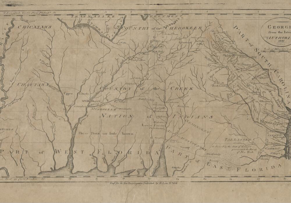
The age of revolutions abroad as well as internal migrations in the United States would continue to fragment and frustrate the settling of Georgia's backcountry and residents' sense of self and citizenship. In contrast to historian Gary Nash's assertion that American independence should be understood as individual and collective acts of resistance crisscrossing racial, ethnic, class, and gender lines, Jennison remains focused on the experience of white Georgia elites. This narrow frame draws on the legacy of Gordon Wood's 1991 magnum opus, The Radicalism of the American Revolution, that similarly omitted women and nonwhites from the record. Regardless of his singular focus, Jennison makes clear that by 1800, Georgia's conservative revolutionaries could broaden their perspective when confronted by the distressing message, reach, and potential consequences of the sweeping revolutions in France and nearby Haiti.
, page 19. Image uploaded by Flickr user Internet Archive Book Images. Image is in public domain.")
Meeting of White Men and Indians, General Oglethorpe meeting Creek Nation. Print originally published in John Lossing's An Outline History of the United States (Sheldon & Co, 1881), p. 19. Image uploaded by Flickr user Internet Archive Book Images. Image is in public domain.
In the second half of Cultivating Race, Jennison shares some of his most insightful findings. Using evocative stories of runaway slaves and the betrayal and murders of allied and non-allied Native Americans, he contends that the conflicts that wracked the Georgia frontier throughout the 1810s were "the products of tensions created by continued American expansion, which repeatedly erupted into violence" (158). With few slave rebellions, early race relations in Georgia were dominated by white paranoia and stories of runaway slaves taking up arms with Native Americans, Spaniards and Britons in Florida. As cotton replaced rice as Georgia's staple crop and carried settlers deeper into the upcountry, tensions between whites and blacks spread. Following the removal of Creek and Cherokee nations by 1838, white Georgians spread white supremacy throughout the state.
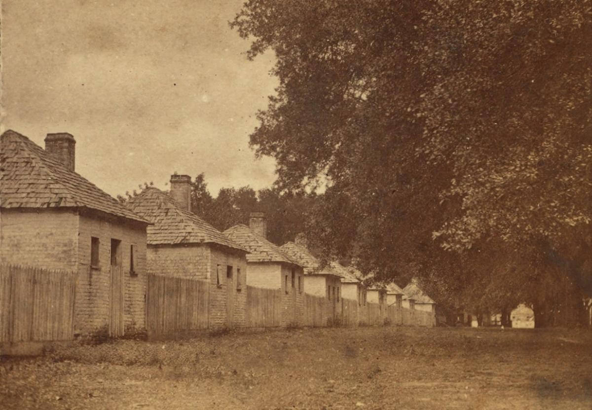
Slavery's development in Georgia made planters richer than they had ever imagined. Planters' economic and ideological legitimacy drew on South Carolinian James Henry Hammond's mudsill theory of racial divisions: convincing poor whites that enslaving African Americans was in their best interests. Jennison surveys white Georgians' opinions on racial and class divisions to great effect, mining the 1852 and 1853 tours of Frederick Law Olmsted, demographic and migratory data, as well as regional comparisons of slave experiences in Savannah as contrasted with the Georgia upcountry.
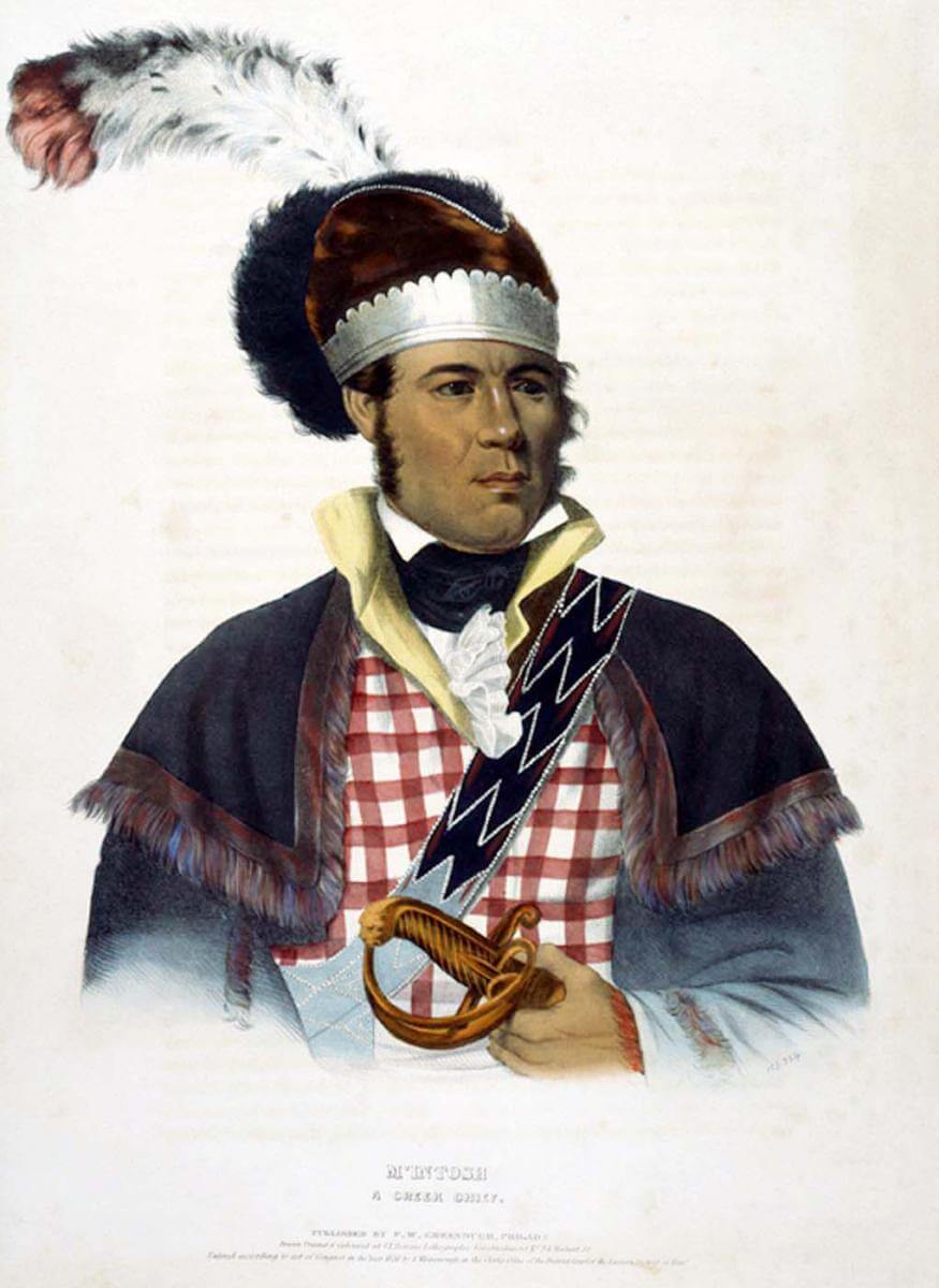
McIntosh: A Creek Chief, 1838. Painting by Charles Bird King. Courtesy of Wikimedia Commons. Image is in public domain.
Jennison's closing chapter revisits Georgia's nineteenth-century historians—mostly politicians, judges, and a cadre of proslavery intellectuals—who competed to write Georgia history and legitimize their own contributions to the state. Exploring the cultural politics of Native removal, Jennison compares the works of writers like George White in the 1850s—who produced mostly popular works and "collections" on Alexander McGillivray and William McIntosh—with the sanitized reflections of Governors George Gilmer and Wilson Lumpkin. Each writer asserted his own "version of the past," hoping to claim admiration and votes.
Cultivating Race ends abruptly but significantly, analyzing legal cases and opinions of the influential, mid-nineteenth century Georgia Supreme Court justice Joseph H. Lumpkin, who, along with his protégé Thomas R. R. Cobb, did more than most other Georgians to shape how whites understood the design and purposes of the color line. From "the vanguard of the southern movement promoting proslavery ideology in the legal realm," Lumpkin and Cobb "legitimated the institution in Georgia so that the laws reflected the racial views dominant in the cotton kingdom" (290, 298). By defining all African Americans, enslaved and freed, as non-citizens, their work effected an oppressive legacy in law and in the writing of history. Watson Jennison's corrective helps readers trace the tangled roots of American apartheid to the beginnings of the last colonial venture in British North America.
About the Author
Thomas Chase Hagood is assistant director for faculty development and recognition at The University of Georgia's Center for Teaching and Learning and is co-director of UGA's Reacting to the Past program. His research interests include the cultural and intellectual history of the nineteenth-century US South, frontier migration, and pedagogical innovation in higher education.
]]>Presentation
About the Speaker
Claudio Saunt is Richard B. Russell professor of American History, co-director of the Center for Visual History, and associate director of the Center for Native American Studies at the University of Georgia. He is currently working on a book on Indian removal. Previous books include West of the Revolution: An Uncommon History of 1776 (New York: W.W. Norton, 2014), A New Order of Things: Property, Power, and the Transformation of the Creek Indians, 1733–1816 (Cambridge: Cambridge University Press, 1999), and Black, White, and Indian: Race and the Unmaking of an American Family (Oxford: Oxford University Press, 2005).
]]>